
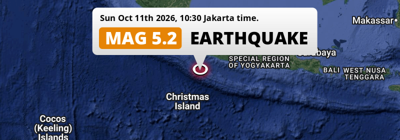
A shallow and significant Magnitude 5.2 earthquake struck in the Indian Ocean 223 kilometer from Bandung, Indonesia in the morning of Sunday October 11th, 2026. Christmas Island is also near its epicenter.
Felt the earthquake? Share this article: 


Earthquake Summary
This earthquake hit under water in the Indian Ocean, 133 kilometers (83 mi) off the coast of Indonesia, 223 kilometer southwest of Bandung in West Java. The center of this earthquake had a very shallow depth of 10 km. Shallow earthquakes usually have a larger impact than earthquakes deep in the earth.
| Date and Time: | Oct 11, 2026 10:30 (Jakarta Time) - Oct 11, 2026 03:30 Universal Time. |
|---|---|
| Location: | 223 km SW of Bandung, West Java, Indonesia. Coordinates 8°36'58"S 106°31'34"E. |
| Map: | 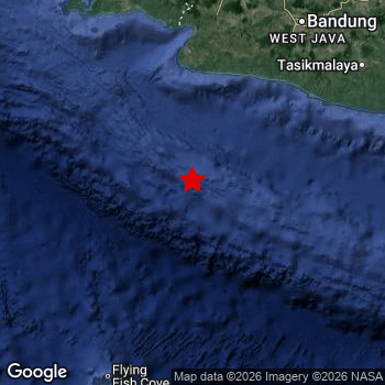 Map of area around epicenter. Click to open in Google Maps. |
| Magnitude: | MAG 5.2 Detected by 90 stations. Maximum Error Range ±0.061 . |
| Depth: | 10 km (6 mi) A very shallow depth. |
| Tsunami Risk: | Low tsunami risk Earthquakes under MAG-6.5 do not usually cause tsunami's. Always stay cautious - More info here. |
Nearby towns and cities
This earthquake struck within proximity of multiple countries. Indonesia and Christmas Island are both within 300km distance of its epicenter.
Located 181 kilometer (112 mi) south of the epicenter of this earthquake, Pelabuhanratu (West Java, Indonesia) is the nearest significant population center.
Multiple major population centers exist within 300km of the earthquake that struck today. Jakarta is located 269 km to the north. Bandung is located 223 km to the north-east. Bekasi is located 270 km to the north.
An overview of nearby towns and cities is available in the overview below.
Overview of nearby places
| Distance | Place |
|---|---|
| 181 km (112 mi) N from epicenter |
Pelabuhanratu West Java, Indonesia. |
| 187 km (116 mi) NE from epicenter |
Banjar West Java, Indonesia. |
| 194 km (121 mi) N from epicenter |
Sukabumi West Java, Indonesia. |
| 206 km (128 mi) N from epicenter |
Cicurug West Java, Indonesia. |
| 207 km (129 mi) NE from epicenter |
Soreang West Java, Indonesia. |
| 210 km (130 mi) NE from epicenter |
Banjaran West Java, Indonesia. |
| 214 km (133 mi) NE from epicenter |
Pameungpeuk West Java, Indonesia. |
| 215 km (134 mi) N from epicenter |
Ciranjang-hilir West Java, Indonesia. |
| 215 km (134 mi) N from epicenter |
Caringin West Java, Indonesia. |
| 216 km (134 mi) NE from epicenter |
Margahayukencana West Java, Indonesia. |
| 217 km (135 mi) NE from epicenter |
Paseh West Java, Indonesia. |
| 221 km (137 mi) SW from epicenter |
Flying Fish Cove All regions, Christmas Island. |
| 223 km (139 mi) NE from epicenter |
Bandung West Java, Indonesia. |
| 224 km (139 mi) NE from epicenter |
Padalarang West Java, Indonesia. |
| 224 km (139 mi) NE from epicenter |
Cimahi West Java, Indonesia. |
| 227 km (141 mi) N from epicenter |
Bogor West Java, Indonesia. |
| 230 km (143 mi) NE from epicenter |
Cileunyi West Java, Indonesia. |
| 230 km (143 mi) N from epicenter |
Ciampea West Java, Indonesia. |
| 234 km (145 mi) NE from epicenter |
Lembang West Java, Indonesia. |
| 235 km (146 mi) NE from epicenter |
Tasikmalaya West Java, Indonesia. |
| 240 km (149 mi) N from epicenter |
Cibinong West Java, Indonesia. |
| 240 km (149 mi) N from epicenter |
Citeureup West Java, Indonesia. |
| 245 km (152 mi) N from epicenter |
Parung West Java, Indonesia. |
| 247 km (153 mi) NE from epicenter |
Ciamis West Java, Indonesia. |
| 248 km (154 mi) NE from epicenter |
Sumedang West Java, Indonesia. |
| 248 km (154 mi) N from epicenter |
Sawangan West Java, Indonesia. |
| 249 km (155 mi) N from epicenter |
Depok West Java, Indonesia. |
| 249 km (155 mi) NE from epicenter |
Sumedang Utara West Java, Indonesia. |
| 250 km (155 mi) NE from epicenter |
Purwakarta West Java, Indonesia. |
| 252 km (157 mi) N from epicenter |
Cileungsir West Java, Indonesia. |
| 253 km (157 mi) N from epicenter |
Rangkasbitung Banten, Indonesia. |
| 254 km (158 mi) N from epicenter |
Pamulang West Java, Indonesia. |
| 256 km (159 mi) N from epicenter |
Serpong West Java, Indonesia. |
| 260 km (162 mi) N from epicenter |
South Tangerang Banten, Indonesia. |
| 261 km (162 mi) N from epicenter |
Pandeglang Banten, Indonesia. |
| 261 km (162 mi) N from epicenter |
Curug Banten, Indonesia. |
| 265 km (165 mi) N from epicenter |
Ciputat West Java, Indonesia. |
| 265 km (165 mi) N from epicenter |
Cikampek West Java, Indonesia. |
| 265 km (165 mi) N from epicenter |
Cikupa West Java, Indonesia. |
| 269 km (167 mi) N from epicenter |
Jakarta Jakarta, Indonesia. |
| 270 km (168 mi) N from epicenter |
Bekasi West Java, Indonesia. |
| 271 km (168 mi) N from epicenter |
Tangerang Banten, Indonesia. |
| 271 km (168 mi) N from epicenter |
Cikarang West Java, Indonesia. |
| 272 km (169 mi) N from epicenter |
Pasarkemis West Java, Indonesia. |
| 273 km (170 mi) NE from epicenter |
Majalengka West Java, Indonesia. |
| 277 km (172 mi) N from epicenter |
Kresek West Java, Indonesia. |
| 278 km (173 mi) N from epicenter |
Sepatan West Java, Indonesia. |
| 280 km (174 mi) N from epicenter |
Teluknaga West Java, Indonesia. |
| 281 km (175 mi) N from epicenter |
Serang Banten, Indonesia. |
| 286 km (178 mi) N from epicenter |
Rengasdengklok West Java, Indonesia. |
| 287 km (178 mi) NE from epicenter |
Majenang Central Java, Indonesia. |
| 295 km (183 mi) NE from epicenter |
Pamanukan West Java, Indonesia. |
| 298 km (185 mi) NE from epicenter |
Sumber West Java, Indonesia. |
Shaking reported by 1 person
People that feel an earthquake may report their experience to the US Geographic Survey. Currently, 1 person has reported shaking in one place in Indonesia.We keep updating this article as more ground reports become available. You may report that you felt this earthquake here.
Places with most reports:
- Karawang, Jawa Barat, Indonesia: 1 person.
Aftershocks detected
This main shock was prefaced by 1 smaller foreshock. A 3.2 magnitude earthquake hit 2 days earlier nearby.
Overview of foreshocks and aftershocks
| Classification | Magnitude | When | Where |
|---|---|---|---|
| Foreshock | M 3.2 |
2 days earlier Oct 9, 2026 02:11 (Jakarta Time) | 49 km (31 mi) NE from Main Shock. |
| Main Shock This Earthquake |
M 5.2 |
Oct 11, 2026 10:30 (Jakarta Time) | - |
More earthquakes coming?
Aftershocks are usually at least 1 order of magnitude less strong than main shocks. The more time passes, the smaller the chance and likely strength of any potential aftershocks.
The chance that a significant earthquake like this one is followed by an even larger earthquake is not so large. On average, scientists estimate a 94% chance that a major earthquake will not be followed by an even larger one. It is still adviced to be aware of this risk
Read: How to Stay Safe during an Earthquake (cdc.gov).Earthquakes like this happen often in the region
Earthquakes of this strength are very common in the region. This is the strongest earthquake to hit since September 14th, 2026, when a 5.3 magnitude earthquake hit 89 km (55 mi) further west. An even stronger magnitude 6.9 earthquake struck on August 2nd, 2019.
In total, 24 earthquakes with a magnitude of 5.2 or higher have been registered within 300km (186 mi) of this epicenter in the past 10 years. This comes down to an average of once every 5 months.
Low tsunami risk
Based on early data it appears this earthquake was not strong enough (lower than MAG-6.5) to be likely to cause destructive tsunami's. However this earthquake appeared to have hit at a shallow depth under sea, so stay cautious and monitor advice from local authorities.
Tsunami Risk Factors
| Factor | Under Sea? | MAG-6.5 or stronger? | Shallow depth? |
|---|---|---|---|
| Explanation | Almost all tsunami's are caused by earthquakes with their epicenter under sea or very near the sea. However stay cautious in coastal areas as earthquakes on land may cause landslides into sea, potentially still causing a local tsunami. | Under MAG 6.5: Very unlikely to cause a tsunami. MAG 6.5 to 7.5: Destructive tsunami's do occur, but are uncommon. Likely to observe small sea level changes. MAG 7.6+: Earthquakes with these magnitudes might produce destructive tsunami's. |
Most destructive tsunami's are caused by shallow earthquakes with a depth between 0 and 100km under the surface of the earth. Deeper tsunami's are unlikely to displace to ocean floor. |
| This Earthquake | This earthquake appears to have struck under the sea. | Not this earthquake. This earthquake had a magnitude of 5.2. Earthquakes of this strength are unlikely to trigger a tsunami. |
This earthquake occurred at a depth of of 10 km (6 mi). Earthquakes this shallow could trigger a tsunami. |
Sources
Last updated 11/10/26 07:08 (). This article is automatically generated based on available data. We keep checking multiple sources for additional information. This article gets updated as new details on this earthquake become available.
- US Geographic Society (USGS): Earthquake us6000u1i6
- European-Mediterranean Seismological Centre (EMSC): Earthquake 20261011_0000061
- Geonames.org: World Cities Database
- Google Maps: Static API
- Earthquakelist.org: Historic Earthquakes Database
Share this article:
