Latest earthquakes near East Kalimantan, Indonesia today
Complete overview of the latest earthquakes near East Kalimantan, Indonesia, updated every minute. Did you feel an earthquake today in East Kalimantan? If an earthquake is happening right now near East Kalimantan (also known as Kalimantan Timur), it will show up within minutes.
Recent East Kalimantan Earthquake News
These are the latest articles published related to earthquakes occurring near East Kalimantan. Check our Earthquake News section for a complete overview of articles written on earthquakes near East Kalimantan and elsewhere.
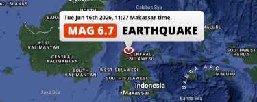 Jun 16, 2026 11:27AM
Shallow M6.7 Earthquake struck on Tuesday Morning near Palu in Indonesia.
Jun 16, 2026 11:27AM
Shallow M6.7 Earthquake struck on Tuesday Morning near Palu in Indonesia.
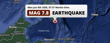 Jun 8, 2026 07:37AM
On Monday Morning a DAMAGING M7.8 Earthquake struck in the Sulawesi Sea near General Santos (The Philippines).
Jun 8, 2026 07:37AM
On Monday Morning a DAMAGING M7.8 Earthquake struck in the Sulawesi Sea near General Santos (The Philippines).
East Kalimantan Earthquake Statistics
Average
A total of 205 earthquakes with a magnitude of four or above have struck within 300 km (186 mi) of East Kalimantan, Indonesia in the past 10 years. This comes down to a yearly average of 20 earthquakes per year, or 1 per month. On average an earthquake will hit near East Kalimantan roughly every 17 days.
A relatively large number of earthquakes occurred near East Kalimantan in 2018. A total of 77 earthquakes (mag 4+) were detected within 300 km of East Kalimantan that year. The strongest had a 6.1 magnitude.

Magnitude Distribution
The table below visualizes the distribution of all earthquakes that occurred within 300km of East Kalimantan in the past 10 years. No earthquakes with a magnitude of 7 or above have occurred near East Kalimantan during this time. Usually, higher magnitudes are less common than lower magnitudes. Small earthquakes with a magnitude below 4 on the Richter scale have been omitted from this overview.
| Magnitude | Earthquakes | Percentage |
|---|---|---|
| Mag. 4 | 182 | 88.78% |
| Mag. 5 | 20 | 9.76% |
| Mag. 6 | 3 | 1.46% |
| Mag. 7 | 0 | 0.0% |
| Mag. 8 | 0 | 0.0% |
| Mag. 9 | 0 | 0.0% |
| Mag. 10 | 0 | 0.0% |
Strongest earthquakes near East Kalimantan
The strongest recent earthquake of the past 10 years near East Kalimantan occurred on Jan 15, 2021 02:28 local time (Asia/Makassar timezone). It had a magnitude of 6.2 and struck 297 kilometers (185 mi) south-east of Balikpapan, at a depth of 18 km. Discover more strong earthquakes near East Kalimantan in the list below.
A longer time ago, a MAG-7.9 earthquake struck on Jan 1, 1996 16:05, 280 kilometers (174 mi) south-east of Bontang. It is the strongest earthquake near East Kalimantan in the past 126 years (Our data goes back to January 1st, 1900).
In the table below you will find the strongest earthquakes that occurred near East Kalimantan, Indonesia in the past 10 years. You can use the tabs to find the heaviest historic earthquakes since the year 1900 or within a specific year or distance from East Kalimantan.
Earthquakes by city in East Kalimantan
Click the links below for earthquake reports for major places in East Kalimantan, Indonesia.
Frequently Asked Questions
These questions are commonly asked in relation to earthquakes occurring near East Kalimantan.
When was the last earthquake in East Kalimantan, Indonesia?
A 3.2 magnitude earthquake hit near East Kalimantan on the evening of July 18, 2026 at 23:42 local time (Asia/Makassar). The center of this earthquake was located 195km north of Bontang at a depth of 57km under water in the Sulawesi Sea. Check the list on our website for any earthquakes occurring near East Kalimantan, Indonesia in the past hours.
What was the strongest earthquake near East Kalimantan, Indonesia?
A 7.9 magnitude earthquake hit near East Kalimantan on the afternoon of January 1, 1996 at 16:05 local time (Asia/Makassar). The center of this earthquake was located 280km east-northeast of Bontang at a depth of 24km under water in the Makassar Strait. This is the strongest earthquake that occurred near East Kalimantan since the year 1900.
How often do earthquakes occur near East Kalimantan, Indonesia?
In the past 10 years, 205 earthquakes with a magnitude of four or higher occurred within a 300 kilometer range from East Kalimantan. This averages to 21 earthquakes yearly, or one earthquake every 18 days.
