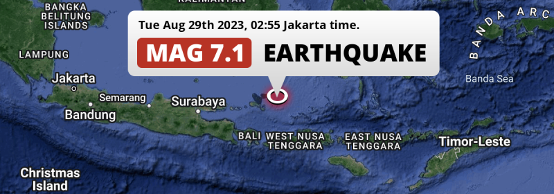
An unusually powerful M7.1 earthquake struck in the Java Sea 252 kilometer from Denpasar, Indonesia deep in the night of Tuesday August 29th, 2023. The USGS has indicated there is a potential risk at tsunami's following this earthquake.
Felt the earthquake? Share this article: 


Earthquake Summary
This earthquake hit under water in the Java Sea, 107 kilometers (66 mi) off the coast of Indonesia, 252 kilometer north-east of Denpasar in Bali. The center of this earthquake had a deep depth of 500 km.
| Date and Time: | Aug 29, 2023 03:55 (Makassar Time) - Aug 28, 2023 19:55 Universal Time. |
|---|---|
| Location: | 252 km NE of Denpasar, Bali, Indonesia. Coordinates 6°47'20"S 116°31'16"E. |
| Map: | 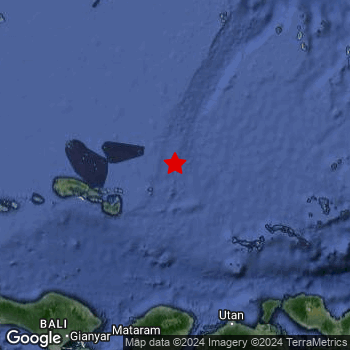 Map of area around epicenter. Click to open in Google Maps. |
| Magnitude: | MAG 7.1 Detected by 15 stations. Maximum Error Range ±0.037 . |
| Depth: | 500 km (311 mi) A deep depth. |
| Max. Intensity: | IV
Light On the Modified Mercalli Scale. |
| Tsunami Risk: | Potential tsunami risk The USGS has indicated there is a potential risk at tsunami's following this earthquake. Always stay cautious - More info here. |
Potential tsunami risk
There is a potential tsunami risk in the aftermath of this earthquake, immediately evacuate to higher grounds away from coastal areas and monitor advice from local authorities. The US Geographic Survey organization has indicated a potential risk for tsunami's following this earthquake.
Tsunami Risk Factors
| Factor | Under Sea? | MAG-6.5 or stronger? | Shallow depth? |
|---|---|---|---|
| Explanation | Almost all tsunami's are caused by earthquakes with their epicenter under sea or very near the sea. However stay cautious in coastal areas as earthquakes on land may cause landslides into sea, potentially still causing a local tsunami. | Under MAG 6.5: Very unlikely to cause a tsunami. MAG 6.5 to 7.5: Destructive tsunami's do occur, but are uncommon. Likely to observe small sea level changes. MAG 7.6+: Earthquakes with these magnitudes might produce destructive tsunami's. |
Most destructive tsunami's are caused by shallow earthquakes with a depth between 0 and 100km under the surface of the earth. Deeper tsunami's are unlikely to displace to ocean floor. |
| This Earthquake | This earthquake appears to have struck under the sea. | This earthquake had a magnitude of 7.1. Earthquakes of this strength could trigger a tsunami. | Not this earthquake. This earthquake occurred at a depth of 500 km (311 mi). Earthquakes this deep in the earth are unlikely to trigger a tsunami. |
Minimal impact predicted
Based on scientific estimates by the US Geographic Survey (USGS), the risk of high fatalities for this earthquake is classified at level GREEN (low). They expect an 65% likelyhood of between 0 and 1 fatalities, and a 96% chance that the number of fatalities falls no higher than 10.
The USGS classifies the economic impact of this earthquake at level GREEN (low). They expect an 65% likelyhood of between 0 and 1 million US Dollars in economic damage and impact, and a 96% chance that the economic impact of this earthquake falls no higher than 10 million USD.
Roughly 4.2 million people exposed to shaking
This earthquake may have been felt by around 4.2 million people. That is the expected population size of the area exposed to a level of shaking of II or higher on the Modified Mercalli scale according to the USGS.
Light shaking and likely no damage may have been experienced by an estimated 857,600 people. At IV, it is the highest MMI level this earthquake has caused. Intensity level III was experienced by the majority of people (around 3.3 million). In their region, weak shaking and probably no damage can be expected. All exposure to shaking was within the borders of Indonesia .
| People | MMI Level | Shaking | Damage |
|---|---|---|---|
| 0 | I |
Not noticable | None |
| 0 | II |
Very weak | None |
| 3,325,000 | III |
Weak | Probably none |
| 857,600 | IV |
Light | Likely none |
| 0 | V |
Moderate | Very light |
| 0 | VI |
Strong | Light |
| 0 | VII |
Very Strong | Moderate |
| 0 | VIII |
Severe | Moderate to heavy |
| 0 | IX |
Violent | Heavy |
| 0 | X |
Extreme | Very heavy |
Nearby towns and cities
This earthquake may have been felt in Indonesia . Mataram in West Nusa Tenggara, Indonesia is the nearest significant place from the epicenter. The earthquake occurred 204 kilometer (127 mi) north-northeast of Mataram.
Multiple major population centers exist within 300km of the earthquake that struck today. Surabaya is located 419 km to the west (intensity unknown, possibly low). Makassar is located 370 km to the east-northeast (intensity unknown, possibly low). Denpasar is located 252 km to the southwest (intensity unknown, possibly low).
A complete list of nearby places is included below. Estimated intensity data (MMI) sourced from a shake-map published by the US Geographic Survey is shown where available (cities without data probably experienced little impact).
Overview of nearby places
| Distance | Place | Intensity (MMI) |
|---|---|---|
| 204 km (127 mi) SSW from epicenter |
Mataram West Nusa Tenggara, Indonesia. |
|
| 210 km (130 mi) SSW from epicenter |
Amlapura city Bali, Indonesia. |
III
Weak |
| 210 km (130 mi) SSW from epicenter |
Amlapura Bali, Indonesia. |
III
Weak |
| 211 km (131 mi) SSW from epicenter |
Bedugul Bali, Indonesia. |
III
Weak |
| 214 km (133 mi) SSE from epicenter |
Sumbawa Besar West Nusa Tenggara, Indonesia. |
III
Weak |
| 215 km (134 mi) S from epicenter |
Praya West Nusa Tenggara, Indonesia. |
|
| 216 km (134 mi) SW from epicenter |
Singaraja Bali, Indonesia. |
III
Weak |
| 230 km (143 mi) SSW from epicenter |
Klungkung Bali, Indonesia. |
IV
Light |
| 232 km (144 mi) SW from epicenter |
Banjar Bali, Indonesia. |
III
Weak |
| 234 km (145 mi) SW from epicenter |
Seririt Bali, Indonesia. |
III
Weak |
| 236 km (147 mi) SW from epicenter |
Ubud Bali, Indonesia. |
IV
Light |
| 248 km (154 mi) SW from epicenter |
Tabanan Bali, Indonesia. |
IV
Light |
| 252 km (157 mi) SW from epicenter |
Denpasar Bali, Indonesia. |
|
| 261 km (162 mi) SW from epicenter |
Kuta Bali, Indonesia. |
|
| 269 km (167 mi) WSW from epicenter |
Wongsorejo East Java, Indonesia. |
|
| 273 km (170 mi) SW from epicenter |
Negara Bali, Indonesia. |
|
| 286 km (178 mi) W from epicenter |
Kalianget East Java, Indonesia. |
|
| 287 km (178 mi) SW from epicenter |
Banyuwangi East Java, Indonesia. |
|
| 287 km (178 mi) WSW from epicenter |
Panji East Java, Indonesia. |
|
| 289 km (180 mi) SE from epicenter |
Dompu West Nusa Tenggara, Indonesia. |
|
| 295 km (183 mi) W from epicenter |
Sumenep East Java, Indonesia. |
|
| 295 km (183 mi) WSW from epicenter |
Situbondo East Java, Indonesia. |
|
| 303 km (188 mi) SW from epicenter |
Muncar East Java, Indonesia. |
|
| 304 km (189 mi) SW from epicenter |
Singojuruh East Java, Indonesia. |
|
| 305 km (190 mi) WSW from epicenter |
Panarukan East Java, Indonesia. |
|
| 306 km (190 mi) SW from epicenter |
Srono East Java, Indonesia. |
|
| 306 km (190 mi) WSW from epicenter |
Balung East Java, Indonesia. |
|
| 306 km (190 mi) SE from epicenter |
Bima West Nusa Tenggara, Indonesia. |
|
| 315 km (196 mi) SW from epicenter |
Genteng East Java, Indonesia. |
|
| 323 km (201 mi) WSW from epicenter |
Bondowoso East Java, Indonesia. |
|
| 329 km (204 mi) WSW from epicenter |
Besuki East Java, Indonesia. |
|
| 339 km (211 mi) W from epicenter |
Pamekasan East Java, Indonesia. |
|
| 347 km (216 mi) WSW from epicenter |
Jember East Java, Indonesia. |
|
| 355 km (221 mi) ENE from epicenter |
Galesong South Sulawesi, Indonesia. |
|
| 365 km (227 mi) W from epicenter |
Sampang East Java, Indonesia. |
|
| 370 km (230 mi) ENE from epicenter |
Makassar South Sulawesi, Indonesia. |
|
| 380 km (236 mi) WSW from epicenter |
Probolinggo East Java, Indonesia. |
|
| 385 km (239 mi) WSW from epicenter |
Kencong East Java, Indonesia. |
|
| 393 km (244 mi) WSW from epicenter |
Lumajang East Java, Indonesia. |
|
| 410 km (255 mi) WSW from epicenter |
Pasuruan East Java, Indonesia. |
|
| 417 km (259 mi) ESE from epicenter |
Labuan Bajo East Nusa Tenggara, Indonesia. |
|
| 418 km (260 mi) NNW from epicenter |
Martapura South Kalimantan, Indonesia. |
|
| 418 km (260 mi) WSW from epicenter |
Bangil East Java, Indonesia. |
|
| 419 km (260 mi) W from epicenter |
Surabaya East Java, Indonesia. |
|
| 426 km (265 mi) W from epicenter |
Sidoarjo East Java, Indonesia. |
|
| 438 km (272 mi) WSW from epicenter |
Lawang East Java, Indonesia. |
|
| 441 km (274 mi) NNW from epicenter |
Banjarmasin South Kalimantan, Indonesia. |
|
| 449 km (279 mi) WSW from epicenter |
Malang East Java, Indonesia. |
|
| 457 km (284 mi) W from epicenter |
Mojokerto East Java, Indonesia. |
|
| 462 km (287 mi) NE from epicenter |
Parepare South Sulawesi, Indonesia. |
|
| 481 km (299 mi) W from epicenter |
Jombang East Java, Indonesia. |
|
| 482 km (300 mi) NNW from epicenter |
Kualakapuas Central Kalimantan, Indonesia. |
|
| 487 km (303 mi) NE from epicenter |
Polewali Provinsi Sulawesi Barat, Indonesia. |
Earthquake Intensity Map
The intensity in shaking and damage by this earthquake is illustrated through the map below. The highest intensity measured for this earthquake is IV.

Shaking reported by 389 people
People that feel an earthquake may report their experience to the US Geographic Survey. Currently, 389 people have reported shaking in 38 places, all within Indonesia.We keep updating this article as more ground reports become available. You may report that you felt this earthquake here.
Places with most reports:
- Kuta, Bali, Indonesia: 173 people.
- Ubud, Bali, Indonesia: 62 people.
- Denpasar, Bali, Indonesia: 48 people.
- Mataram, Nusa Tenggara Barat, Indonesia: 20 people.
- Praya, Nusa Tenggara Barat, Indonesia: 15 people.
- Klungkung, Bali, Indonesia: 14 people.
- Tabanan, Bali, Indonesia: 10 people.
- Karangasem, Bali, Indonesia: 9 people.
- Singaraja, Bali, Indonesia: 4 people.
- Banyuwangi, Jawa Timur, Indonesia: 3 people.
4 Aftershocks detected
This main shock was followed by 4 smaller aftershocks. At a distance of 81 km (50 mi) east-southeast of this earthquake, an aftershock struck 13 mins later. It measured a magnitude of 5.7
Overview of foreshocks and aftershocks
| Classification | Magnitude | When | Where |
|---|---|---|---|
| Main Shock This Earthquake |
M 7.1 |
Aug 29, 2023 03:55 (Makassar Time) | - |
| Aftershock | M 5.5 |
11 mins later Aug 29, 2023 04:06 (Makassar Time) | 11 km (7 mi) ESE from Main Shock. |
| Aftershock | M 5.7 |
13 mins later Aug 29, 2023 04:08 (Makassar Time) | 81 km (50 mi) ESE from Main Shock. |
| Aftershock | M 3.1 |
1 hr later Aug 29, 2023 05:24 (Makassar Time) | 45 km (28 mi) S from Main Shock. |
| Aftershock | M 3.4 |
5 hrs later Aug 29, 2023 08:53 (Makassar Time) | 21 km (13 mi) SSW from Main Shock. |
More earthquakes coming?
The risk of aftershocks decreases rapidly over time. Usually, aftershocks are at least one order of magnitude lower than a main shock.
It's always adviced to be cautious of the risk of a larger shock following any significant earthquake, however this risk is fairly small. There is a roughly 94 percent change that no larger main shock will follow in the days following this earthquake.
Read: How to Stay Safe during an Earthquake (cdc.gov).This is an unusually powerful earthquake
No earthquake of this strength has struck this region for a long time. Our data goes back 10 years, and no earthquakes measuring a magnitude of 7.1 or higher have been detected within 300 km (186 mi) of this epicenter.
Sources
Last updated 27/10/23 15:48 (). This article is automatically generated based on available data. We keep checking multiple sources for additional information. This article gets updated as new details on this earthquake become available.
- US Geographic Society (USGS): Earthquake us7000krjx
- European-Mediterranean Seismological Centre (EMSC): Earthquake 20230828_0000197
- Geonames.org: World Cities Database
- Google Maps: Static API
- Earthquakelist.org: Historic Earthquakes Database
Share this article:
