
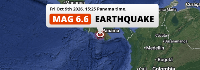
A shallow and strong Magnitude 6.6 aftershock struck under land 68 kilometer from Santiago de Veraguas in Panama in the afternoon of Friday October 9th, 2026. The USGS has indicated there is a potential risk at tsunami's following this earthquake. Another nearby country is Costa Rica.
Felt the earthquake? Share this article: 


Earthquake Summary
The earthquake struck on land in Panama, 68 kilometer (42 mi) southwest of Santiago de Veraguas in Veraguas. The center of this earthquake had a very shallow depth of 10 km. Shallow earthquakes usually have a larger impact than earthquakes deep in the earth.
| Date and Time: | Oct 9, 2026 03:25PM (Panama Time) - Oct 9, 2026 20:25 Universal Time. |
|---|---|
| Location: | 68 km SW of Santiago de Veraguas, Veraguas, Panama. Coordinates 7°43'3"N 81°28'7"W. |
| Map: | 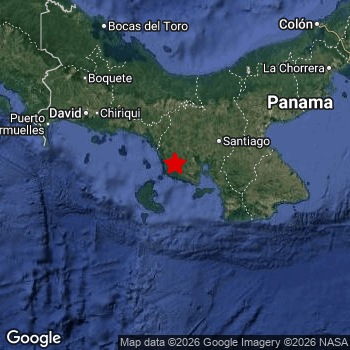 Map of area around epicenter. Click to open in Google Maps. |
| Magnitude: | MAG 6.6 Detected by 199 stations. Maximum Error Range ±0.062 . |
| Depth: | 10 km (6 mi) A very shallow depth. |
| Max. Intensity: | IX
Violent On the Modified Mercalli Scale. |
| Tsunami Risk: | Potential tsunami risk The USGS has indicated there is a potential risk at tsunami's following this earthquake. Always stay cautious - More info here. |
Potential tsunami risk
There is a potential tsunami risk in the aftermath of this earthquake, immediately evacuate to higher grounds away from coastal areas and monitor advice from local authorities. The US Geographic Survey organization has indicated a potential risk for tsunami's following this earthquake.
Tsunami Risk Factors
| Factor | Under Sea? | MAG-6.5 or stronger? | Shallow depth? |
|---|---|---|---|
| Explanation | Almost all tsunami's are caused by earthquakes with their epicenter under sea or very near the sea. However stay cautious in coastal areas as earthquakes on land may cause landslides into sea, potentially still causing a local tsunami. | Under MAG 6.5: Very unlikely to cause a tsunami. MAG 6.5 to 7.5: Destructive tsunami's do occur, but are uncommon. Likely to observe small sea level changes. MAG 7.6+: Earthquakes with these magnitudes might produce destructive tsunami's. |
Most destructive tsunami's are caused by shallow earthquakes with a depth between 0 and 100km under the surface of the earth. Deeper tsunami's are unlikely to displace to ocean floor. |
| This Earthquake | This earthquake appears to have struck on land near a coastal area (2 km from the sea). | This earthquake had a magnitude of 6.6. Earthquakes of this strength could trigger a tsunami. | This earthquake occurred at a depth of of 10 km (6 mi). Earthquakes this shallow could trigger a tsunami. |
Significant impact predicted
Based on scientific estimates by the US Geographic Survey (USGS), the risk of high fatalities for this earthquake is classified at level YELLOW (significant). They expect an 50% likelyhood of between 0 and 1 fatalities, and a 99% chance that the number of fatalities falls no higher than 100.
The USGS classifies the economic impact of this earthquake at level YELLOW (significant). They expect an 38% likelyhood of between 10 and 100 million US Dollars in economic damage and impact, and a 95% chance that the economic impact of this earthquake falls no higher than 1,000 million USD.
Roughly 1.4 million people exposed to shaking
This earthquake may have been felt by around 1.4 million people. That is the expected population size of the area exposed to a level of shaking of II or higher on the Modified Mercalli scale according to the USGS.
Severe shaking and likely moderate to heavy damage may have been experienced by an estimated 410 people. At VIII, it is the highest MMI level this earthquake has caused. The majority of people (roughly 0.8 million) live in an area exposed to level IV, where light shaking and likely no damage is expected. All exposure to shaking was within the borders of Panama .
| People | MMI Level | Shaking | Damage |
|---|---|---|---|
| 0 | I |
Not noticable | None |
| 0 | II |
Very weak | None |
| 0 | III |
Weak | Probably none |
| 801,300 | IV |
Light | Likely none |
| 555,100 | V |
Moderate | Very light |
| 59,470 | VI |
Strong | Light |
| 11,080 | VII |
Very Strong | Moderate |
| 410 | VIII |
Severe | Moderate to heavy |
| 0 | IX |
Violent | Heavy |
| 0 | X |
Extreme | Very heavy |
Nearby towns and cities
This earthquake struck within proximity of multiple countries. Panama and Costa Rica are both within 300km distance of its epicenter.
Santiago de Veraguas in Veraguas, Panama is the nearest significant place from the epicenter. The earthquake occurred 68 kilometer (42 mi) southwest of Santiago de Veraguas. The intensity of shaking and damage in Santiago de Veraguas is estimated to be around level V on the Modified Mercalli Intensity scale (moderate shaking, very light damage).
Multiple major population centers exist within 300km of the earthquake that struck today. Panamá is located 257 km to the north-east (intensity unknown, possibly low). San Miguelito is located 265 km to the north-east (intensity unknown, possibly low). San José is located 378 km to the northwest (intensity unknown, possibly low).
A complete list of nearby places is included below. Estimated intensity data (MMI) sourced from a shake-map published by the US Geographic Survey is shown where available (cities without data probably experienced little impact).
Overview of nearby places
| Distance | Place | Intensity (MMI) |
|---|---|---|
| 68 km (42 mi) NE from epicenter |
Santiago de Veraguas Veraguas, Panama. |
V
Moderate |
| 129 km (80 mi) NW from epicenter |
Pedregal Chiriquí, Panama. |
V
Moderate |
| 132 km (82 mi) NW from epicenter |
David Chiriquí, Panama. |
IV
Light |
| 151 km (94 mi) NE from epicenter |
Penonomé Coclé, Panama. |
IV
Light |
| 155 km (96 mi) NW from epicenter |
La Concepción Chiriquí, Panama. |
IV
Light |
| 223 km (139 mi) NW from epicenter |
Changuinola Bocas del Toro, Panama. |
|
| 226 km (140 mi) NE from epicenter |
La Chorrera Panamá Oeste, Panama. |
|
| 241 km (150 mi) NE from epicenter |
Veracruz Panamá Oeste, Panama. |
|
| 243 km (151 mi) NE from epicenter |
Arraiján Panamá Oeste, Panama. |
|
| 251 km (156 mi) NE from epicenter |
Colón Colón, Panama. |
|
| 252 km (157 mi) NE from epicenter |
Ancón Panamá, Panama. |
|
| 252 km (157 mi) NE from epicenter |
El Chorrillo Panamá, Panama. |
|
| 253 km (157 mi) NE from epicenter |
Curundú Panamá, Panama. |
|
| 257 km (160 mi) NE from epicenter |
Sabanitas Colón, Panama. |
|
| 257 km (160 mi) NE from epicenter |
Panamá Panamá, Panama. |
|
| 257 km (160 mi) NE from epicenter |
Cativá Colón, Panama. |
|
| 259 km (161 mi) NE from epicenter |
Chilibre Panamá, Panama. |
|
| 261 km (162 mi) NE from epicenter |
Río Abajo Panamá, Panama. |
|
| 262 km (163 mi) NE from epicenter |
Las Cumbres Panamá, Panama. |
|
| 262 km (163 mi) NE from epicenter |
Alcalde Díaz Panamá, Panama. |
|
| 263 km (163 mi) NE from epicenter |
Parque Lefevre Panamá, Panama. |
|
| 264 km (164 mi) NE from epicenter |
La Cabima Panamá, Panama. |
|
| 265 km (165 mi) NE from epicenter |
San Miguelito Panamá, Panama. |
|
| 267 km (166 mi) NE from epicenter |
Juan Díaz Panamá, Panama. |
|
| 270 km (168 mi) NE from epicenter |
Pedregal Panamá, Panama. |
|
| 275 km (171 mi) NE from epicenter |
Nuevo Belén Panamá, Panama. |
|
| 275 km (171 mi) NE from epicenter |
Tocumen Panamá, Panama. |
|
| 306 km (190 mi) NW from epicenter |
San Isidro San José, Costa Rica. |
|
| 306 km (190 mi) NW from epicenter |
Limón Limón, Costa Rica. |
|
| 344 km (214 mi) NW from epicenter |
Turrialba Cartago, Costa Rica. |
|
| 354 km (220 mi) NW from epicenter |
Paraíso Cartago, Costa Rica. |
|
| 360 km (224 mi) NW from epicenter |
Cartago Cartago, Costa Rica. |
|
| 371 km (231 mi) NW from epicenter |
Patarrá San José, Costa Rica. |
|
| 372 km (231 mi) NW from epicenter |
San Miguel San José, Costa Rica. |
|
| 373 km (232 mi) NW from epicenter |
Curridabat San José, Costa Rica. |
|
| 374 km (232 mi) NW from epicenter |
Aserrí San José, Costa Rica. |
|
| 375 km (233 mi) NW from epicenter |
Ipís San José, Costa Rica. |
|
| 375 km (233 mi) NW from epicenter |
San Pedro San José, Costa Rica. |
|
| 376 km (234 mi) NW from epicenter |
Purral San José, Costa Rica. |
|
| 377 km (234 mi) NW from epicenter |
Guadalupe San José, Costa Rica. |
|
| 378 km (235 mi) NW from epicenter |
San Vicente San José, Costa Rica. |
|
| 378 km (235 mi) NW from epicenter |
San Vicente de Moravia San José, Costa Rica. |
|
| 378 km (235 mi) NW from epicenter |
San Felipe San José, Costa Rica. |
|
| 378 km (235 mi) NW from epicenter |
San José San José, Costa Rica. |
|
| 378 km (235 mi) NW from epicenter |
Tejar San José, Costa Rica. |
|
| 380 km (236 mi) NW from epicenter |
San Juan San José, Costa Rica. |
|
| 382 km (237 mi) NW from epicenter |
San Rafael San José, Costa Rica. |
|
| 386 km (240 mi) NW from epicenter |
San Francisco Heredia, Costa Rica. |
|
| 388 km (241 mi) NW from epicenter |
Mercedes Norte Heredia, Costa Rica. |
|
| 389 km (242 mi) NW from epicenter |
San Rafael Abajo San José, Costa Rica. |
|
| 395 km (245 mi) NW from epicenter |
Alajuela Alajuela, Costa Rica. |
|
| 447 km (278 mi) NW from epicenter |
Puntarenas Puntarenas, Costa Rica. |
|
| 500 km (311 mi) NW from epicenter |
Cañas Guanacaste, Costa Rica. |
Earthquake Intensity Map
The graph below overlays a map of the region around the epicenter with earthquake intensity data provided by the US Geographic Survey. The highest intensity level detected for this earthquake is VIII.
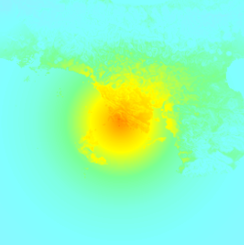
Shaking reported by 25 people in 2 countries
People that feel an earthquake may report their experience to the US Geographic Survey. Currently, 25 people have reported shaking in 21 places in 2 countries (Panama, Costa Rica).We keep updating this article as more ground reports become available. You may report that you felt this earthquake here.
Places with most reports:
- Panamá, Panamá, Panama: 3 people.
- Almirante, Bocas del Toro, Panama: 2 people.
- San Miguelito, Panamá, Panama: 2 people.
- Soná, Veraguas, Panama: 1 person.
- San José, San José, Costa Rica: 1 person.
- Tocumen, Panamá, Panama: 1 person.
- San Vicente, San José, Costa Rica: 1 person.
- Ancón, Panamá, Panama: 1 person.
- San Isidro (San Isidro de El General), San José, Costa Rica: 1 person.
- San Pedro, San José, Costa Rica: 1 person.
This is likely an aftershock
Approximately 2 hrs before this earthquake hit, a larger 7.7 magnitude earthquake struck 78 km (49 mi) east of this one. For that reason, we classify the Mag. 6.6 earthquake as an aftershock.
Overview of foreshocks and aftershocks
| Classification | Magnitude | When | Where |
|---|---|---|---|
| Foreshock | M 2.6 |
12 hrs earlier Oct 9, 2026 12:53AM (Panama Time) | 5 km (2.9 mi) SE from Main Shock. |
| Main Shock | M 7.7 |
Oct 9, 2026 12:56PM (Panama Time) | - |
| Aftershock | M 3.4 |
19 mins later Oct 9, 2026 01:15PM (Panama Time) | 7 km (4 mi) W from Main Shock. |
| Aftershock | M 5.5 |
26 mins later Oct 9, 2026 01:22PM (Panama Time) | 53 km (33 mi) E from Main Shock. |
| Aftershock | M 3.9 |
35 mins later Oct 9, 2026 01:30PM (Panama Time) | 66 km (41 mi) W from Main Shock. |
| Aftershock | M 5.8 |
42 mins later Oct 9, 2026 01:37PM (Panama Time) | 44 km (27 mi) E from Main Shock. |
| Aftershock | M 5.0 |
51 mins later Oct 9, 2026 01:47PM (Panama Time) | 36 km (22 mi) W from Main Shock. |
| Aftershock | M 5.0 |
54 mins later Oct 9, 2026 01:50PM (Panama Time) | 77 km (48 mi) E from Main Shock. |
| Aftershock | M 5.0 |
1 hr later Oct 9, 2026 02:04PM (Panama Time) | 53 km (33 mi) W from Main Shock. |
| Aftershock | M 4.8 |
1 hr later Oct 9, 2026 02:17PM (Panama Time) | 30 km (19 mi) W from Main Shock. |
| Aftershock | M 4.6 |
1 hr later Oct 9, 2026 02:25PM (Panama Time) | 61 km (38 mi) NW from Main Shock. |
| Aftershock | M 3.8 |
2 hrs later Oct 9, 2026 02:27PM (Panama Time) | 33 km (21 mi) W from Main Shock. |
| Aftershock | M 4.7 |
2 hrs later Oct 9, 2026 02:32PM (Panama Time) | 21 km (13 mi) E from Main Shock. |
| Aftershock | M 4.4 |
2 hrs later Oct 9, 2026 02:41PM (Panama Time) | 36 km (22 mi) SW from Main Shock. |
| Aftershock | M 4.5 |
2 hrs later Oct 9, 2026 02:42PM (Panama Time) | 61 km (38 mi) E from Main Shock. |
| Aftershock | M 4.8 |
2 hrs later Oct 9, 2026 02:45PM (Panama Time) | 70 km (44 mi) E from Main Shock. |
| Aftershock | M 5.2 |
2 hrs later Oct 9, 2026 02:48PM (Panama Time) | 55 km (34 mi) W from Main Shock. |
| Aftershock | M 4.9 |
2 hrs later Oct 9, 2026 03:20PM (Panama Time) | 29 km (18 mi) W from Main Shock. |
| Aftershock | M 5.0 |
2 hrs later Oct 9, 2026 03:21PM (Panama Time) | 27 km (17 mi) SE from Main Shock. |
| Aftershock This Earthquake |
M 6.6 |
2 hrs later Oct 9, 2026 03:25PM (Panama Time) | 79 km (49 mi) W from Main Shock. |
| Aftershock | M 4.9 |
3 hrs later Oct 9, 2026 03:41PM (Panama Time) | 37 km (23 mi) W from Main Shock. |
| Aftershock | M 5.0 |
3 hrs later Oct 9, 2026 03:42PM (Panama Time) | 78 km (48 mi) W from Main Shock. |
| Aftershock | M 4.9 |
3 hrs later Oct 9, 2026 03:54PM (Panama Time) | 82 km (51 mi) W from Main Shock. |
| Aftershock | M 4.9 |
3 hrs later Oct 9, 2026 04:05PM (Panama Time) | 77 km (48 mi) W from Main Shock. |
| Aftershock | M 4.2 |
4 hrs later Oct 9, 2026 04:30PM (Panama Time) | 91 km (57 mi) W from Main Shock. |
| Aftershock | M 4.6 |
4 hrs later Oct 9, 2026 04:47PM (Panama Time) | 63 km (39 mi) W from Main Shock. |
| Aftershock | M 4.3 |
4 hrs later Oct 9, 2026 05:13PM (Panama Time) | 74 km (46 mi) W from Main Shock. |
| Aftershock | M 4.4 |
5 hrs later Oct 9, 2026 05:41PM (Panama Time) | 79 km (49 mi) E from Main Shock. |
| Aftershock | M 4.3 |
5 hrs later Oct 9, 2026 05:45PM (Panama Time) | 10 km (6 mi) N from Main Shock. |
| Aftershock | M 4.1 |
5 hrs later Oct 9, 2026 05:54PM (Panama Time) | 13 km (8 mi) E from Main Shock. |
| Aftershock | M 4.3 |
5 hrs later Oct 9, 2026 06:06PM (Panama Time) | 72 km (44 mi) W from Main Shock. |
| Aftershock | M 5.0 |
5 hrs later Oct 9, 2026 06:10PM (Panama Time) | 34 km (21 mi) SE from Main Shock. |
| Aftershock | M 5.0 |
5 hrs later Oct 9, 2026 06:10PM (Panama Time) | 34 km (21 mi) SE from Main Shock. |
| Aftershock | M 5.4 |
5 hrs later Oct 9, 2026 06:12PM (Panama Time) | 76 km (47 mi) E from Main Shock. |
| Aftershock | M 5.4 |
5 hrs later Oct 9, 2026 06:12PM (Panama Time) | 76 km (47 mi) E from Main Shock. |
| Aftershock | M 4.9 |
5 hrs later Oct 9, 2026 06:23PM (Panama Time) | 70 km (44 mi) W from Main Shock. |
| Aftershock | M 3.9 |
6 hrs later Oct 9, 2026 06:35PM (Panama Time) | 85 km (53 mi) W from Main Shock. |
| Aftershock | M 4.7 |
6 hrs later Oct 9, 2026 06:57PM (Panama Time) | 78 km (48 mi) W from Main Shock. |
| Aftershock | M 4.6 |
6 hrs later Oct 9, 2026 07:00PM (Panama Time) | 7 km (5 mi) NE from Main Shock. |
| Aftershock | M 4.8 |
6 hrs later Oct 9, 2026 07:03PM (Panama Time) | 56 km (35 mi) E from Main Shock. |
| Aftershock | M 4.8 |
6 hrs later Oct 9, 2026 07:03PM (Panama Time) | 56 km (35 mi) E from Main Shock. |
| Aftershock | M 4.5 |
6 hrs later Oct 9, 2026 07:10PM (Panama Time) | 28 km (17 mi) S from Main Shock. |
| Aftershock | M 4.3 |
6 hrs later Oct 9, 2026 07:13PM (Panama Time) | 75 km (47 mi) W from Main Shock. |
| Aftershock | M 4.1 |
6 hrs later Oct 9, 2026 07:22PM (Panama Time) | 86 km (53 mi) W from Main Shock. |
| Aftershock | M 4.7 |
7 hrs later Oct 9, 2026 08:11PM (Panama Time) | 21 km (13 mi) E from Main Shock. |
| Aftershock | M 4.2 |
7 hrs later Oct 9, 2026 08:23PM (Panama Time) | 51 km (32 mi) E from Main Shock. |
| Aftershock | M 4.6 |
8 hrs later Oct 9, 2026 08:35PM (Panama Time) | 61 km (38 mi) W from Main Shock. |
| Aftershock | M 4.3 |
8 hrs later Oct 9, 2026 08:47PM (Panama Time) | 86 km (54 mi) W from Main Shock. |
| Aftershock | M 4.3 |
8 hrs later Oct 9, 2026 09:07PM (Panama Time) | 80 km (50 mi) W from Main Shock. |
| Aftershock | M 4.3 |
8 hrs later Oct 9, 2026 09:13PM (Panama Time) | 93 km (58 mi) W from Main Shock. |
| Aftershock | M 4.4 |
8 hrs later Oct 9, 2026 09:20PM (Panama Time) | 71 km (44 mi) W from Main Shock. |
| Aftershock | M 5.1 |
9 hrs later Oct 9, 2026 09:26PM (Panama Time) | 37 km (23 mi) E from Main Shock. |
More earthquakes coming?
The risk of aftershocks decreases rapidly over time. Usually, aftershocks are at least one order of magnitude lower than a main shock.
In only six percent of cases, significant earthquakes are followed by a larger main shock, making the current earthquake a foreshock. While the chance of this happening is not so large, it is adviced to maintain cautiousness in the hours and days following a major earthquake.
Read: How to Stay Safe during an Earthquake (cdc.gov).Earthquakes like this are common in the region
Earthquakes of this strength occur quite regularly in the region. In total, 3 earthquakes with a magnitude of 6.6 or higher have been registered within 300km (186 mi) of this epicenter in the past 10 years. This comes down to an average of once every 3 years.
Sources
Last updated 10/10/26 02:38 (). As more information on this earthquake becomes available this article will be updated. This article is automatically composed based on data originating from multiple sources.
- US Geographic Society (USGS): Earthquake us6000u19w
- European-Mediterranean Seismological Centre (EMSC): Earthquake 20261009_0000316
- Geonames.org: World Cities Database
- Google Maps: Static API
- Earthquakelist.org: Historic Earthquakes Database
Share this article:
