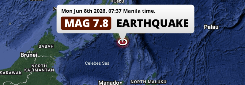
In the Sulawesi Sea 59 kilometer from General Santos, The Philippines, a DAMAGING and very strong M7.8 earthquake occurred in the morning of Monday June 8th, 2026. Mag 6.5+ earthquakes at shallow depth under sea have the potential to cause tsunami's. Another nearby country is Indonesia.
Felt the earthquake? Share this article: 


Earthquake Summary
This earthquake hit under water in the Sulawesi Sea, 24 kilometers (15 mi) off the coast of The Philippines, 59 kilometer south of General Santos in Soccsksargen. The center of this earthquake had a quite shallow depth of 57 km. Shallow earthquakes usually have a larger impact than earthquakes deep in the earth.
| Date and Time: | Jun 8, 2026 07:37AM (Manila Time) - Jun 7, 2026 23:37 Universal Time. |
|---|---|
| Location: | 59 km south of General Santos, Soccsksargen, The Philippines. Coordinates 5°35'58"N 125°3'22"E. |
| Map: | 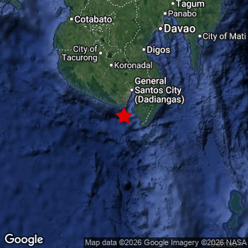 Map of area around epicenter. Click to open in Google Maps. |
| Magnitude: | MAG 7.8 Detected by 125 stations. Maximum Error Range ±0.028 . |
| Depth: | 57 km (35 mi) A quite shallow depth. |
| Max. Intensity: | IX
Violent On the Modified Mercalli Scale. |
| Tsunami Risk: | Potential Tsunami Risk Mag 6.5+ earthquakes at shallow depth under sea have the potential to cause tsunami's. Always stay cautious - More info here. |
Potential Tsunami Risk
There is a potential tsunami risk in the aftermath of this earthquake, immediately evacuate to higher grounds away from coastal areas and monitor advice from local authorities. This earthquake checks all the likely tsunami risk factors: under sea, at a magnitude of MAG-6.5+ and at a shallow depth.
Tsunami Risk Factors
| Factor | Under Sea? | MAG-6.5 or stronger? | Shallow depth? |
|---|---|---|---|
| Explanation | Almost all tsunami's are caused by earthquakes with their epicenter under sea or very near the sea. However stay cautious in coastal areas as earthquakes on land may cause landslides into sea, potentially still causing a local tsunami. | Under MAG 6.5: Very unlikely to cause a tsunami. MAG 6.5 to 7.5: Destructive tsunami's do occur, but are uncommon. Likely to observe small sea level changes. MAG 7.6+: Earthquakes with these magnitudes might produce destructive tsunami's. |
Most destructive tsunami's are caused by shallow earthquakes with a depth between 0 and 100km under the surface of the earth. Deeper tsunami's are unlikely to displace to ocean floor. |
| This Earthquake | This earthquake appears to have struck under the sea. | This earthquake had a magnitude of 7.8. Earthquakes of this strength could trigger a tsunami. | This earthquake occurred at a depth of of 57 km (35 mi). Earthquakes this shallow could trigger a tsunami. |
Significant impact predicted
The US Geographic Survey (USGS) describes the impact of this earthquake as follows:
At least 71 people killed, 1,236 injured and 7 missing; 13,075 houses destroyed and 84,188 damaged; 783 critical infrastructure, 15 roads, 8 bridges and 2 seaports damaged, including the closure of General Santos City Airport; communication, power and water outages occurred; 35 landslides occurred in SOCCSKSARGEN, including the worst affected areas of General Santos, Sarangani and South Cotabato. At least 21 people killed, 79 injured and 13 missing; 5,272 houses destroyed and 10,690 damaged; 751 critical infrastructure damaged; power and water outages occurred; 35 landslides and 7 ground cracks occurred in Davao Region. At least one person injured, 6 houses destroyed and 40 damaged; 4 critical infrastructure damaged in Bangsamoro Autonomous Region in Muslim Mindanao. At least six houses destroyed and one house and one critical infrastructure damaged in Zamboanga Peninsula. Maximum intensity IX. Uplift of 2 m occurred along the coastline of southern Mindanao from Glan to Jose Abad Santos exposing coral reefs and other previously submerged areas. At least one person killed, four injured and 100 homes and some buildings damaged in Kabupaten Kepulauan Sangihe and Kabupaten Kepulauan Talaud, Indonesia. A tsunami was generated with the largest maximum wave height listed in meters based on location: 1.48 at Kiamba, Philippines; .83 on Pulau Sangihe, Indonesia; .3 at Miyazaki Ko, Japan; .03 on Malakal, Palau; .02 at Pago Bay, Guam, U. S. Territory.
Based on scientific estimates by the USGS, the risk of high fatalities for this earthquake is classified at level ORANGE (orange). They expect an 38% likelyhood of between 100 and 1,000 fatalities, and a 98% chance that the number of fatalities falls between 1 and 10,000.
The USGS classifies the economic impact of this earthquake at level ORANGE (orange). They expect an 35% likelyhood of between 100 and 1,000 million US Dollars in economic damage and impact, and a 92% chance that the economic impact of this earthquake falls between 10 and 100,000 million USD.
Roughly 29 million people exposed to shaking
The USGS has published a report estimating the number of people exposed to this earthquake. Acoording to their analysis, roughly 29 million have been exposed to shaking at an MMI level of II or higher.
The highest earthquake impact level for this earthquake is IX, which corresponds with violent shaking and likely heavy damage. Roughly 9,620 people are expected to be exposed to this level. Intensity level IV was experienced by a large group of people (around 11 million). In their region, light shaking and likely no damage can be expected.
People in 2 countries have been exposed to shaking. In The Philippines , around 28 million people, with impact levels up to IX (violent shaking, likely heavy damage). In Indonesia, shaking was experienced too.
| People | MMI Level | Shaking | Damage |
|---|---|---|---|
| 0 | I |
Not noticable | None |
| 0 | II |
Very weak | None |
| 64,970 | III |
Weak | Probably none |
| 11,100,000 | IV |
Light | Likely none |
| 7,179,000 | V |
Moderate | Very light |
| 5,930,000 | VI |
Strong | Light |
| 2,919,000 | VII |
Very Strong | Moderate |
| 1,405,000 | VIII |
Severe | Moderate to heavy |
| 9,620 | IX |
Violent | Heavy |
| 0 | X |
Extreme | Very heavy |
Nearby towns and cities
The Philippines and Indonesia are both located within 300km distance of the epicenter of the earthquake. Futher away, this earthquake may also have been felt in Malaysia, Palau and Brunei.
Glan in Soccsksargen, The Philippines is the nearest significant place from the epicenter. The earthquake occurred 30 kilometer (19 mi) southwest of Glan. The intensity of shaking and damage in Glan is estimated to be around level VIII on the Modified Mercalli Intensity scale (severe shaking, likely moderate to heavy damage).
Multiple large cities are in proximity of today's earthquake. General Santos is located 59 km to the north and experienced an intensity of VIII (severe shaking, likely moderate to heavy damage). Davao is located 175 km to the north and experienced an intensity of VI (strong shaking, probably light damage). Budta is located 191 km to the north and experienced an intensity of VI (strong shaking, probably light damage).
A complete list of nearby places is included below. Estimated intensity data (MMI) sourced from a shake-map published by the US Geographic Survey is shown where available (cities without data probably experienced little impact).
Overview of nearby places
| Distance | Place | Intensity (MMI) |
|---|---|---|
| 30 km (19 mi) NE from epicenter |
Glan Soccsksargen, The Philippines. |
VIII
Severe |
| 49 km (30 mi) NE from epicenter |
Malapatan Soccsksargen, The Philippines. |
VIII
Severe |
| 59 km (37 mi) N from epicenter |
General Santos Soccsksargen, The Philippines. |
VIII
Severe |
| 62 km (39 mi) NE from epicenter |
Alabel Soccsksargen, The Philippines. |
VIII
Severe |
| 69 km (43 mi) N from epicenter |
Polomolok Soccsksargen, The Philippines. |
VII
Very Strong |
| 79 km (49 mi) NW from epicenter |
Lake Sebu Soccsksargen, The Philippines. |
VIII
Severe |
| 80 km (50 mi) N from epicenter |
Maluñgun Soccsksargen, The Philippines. |
VII
Very Strong |
| 83 km (52 mi) N from epicenter |
Tupi Soccsksargen, The Philippines. |
VII
Very Strong |
| 93 km (58 mi) N from epicenter |
Surallah Soccsksargen, The Philippines. |
VIII
Severe |
| 97 km (60 mi) N from epicenter |
Bañga Soccsksargen, The Philippines. |
VII
Very Strong |
| 103 km (64 mi) N from epicenter |
Koronadal Soccsksargen, The Philippines. |
VII
Very Strong |
| 110 km (68 mi) NE from epicenter |
Malita Davao, The Philippines. |
VII
Very Strong |
| 116 km (72 mi) NE from epicenter |
Santa Maria Davao, The Philippines. |
VII
Very Strong |
| 125 km (78 mi) NW from epicenter |
Isulan Soccsksargen, The Philippines. |
VII
Very Strong |
| 128 km (80 mi) N from epicenter |
Buluan Rehiyong Autonomo sa Muslim na Mindanao, The Philippines. |
VII
Very Strong |
| 129 km (80 mi) N from epicenter |
Tacurong Soccsksargen, The Philippines. |
VII
Very Strong |
| 131 km (81 mi) N from epicenter |
Magsaysay Davao, The Philippines. |
VII
Very Strong |
| 132 km (82 mi) N from epicenter |
Digos Davao, The Philippines. |
VII
Very Strong |
| 133 km (83 mi) NW from epicenter |
Laguilayan Soccsksargen, The Philippines. |
VII
Very Strong |
| 133 km (83 mi) N from epicenter |
Bansalan Davao, The Philippines. |
VI
Strong |
| 156 km (97 mi) NW from epicenter |
Maganoy Rehiyong Autonomo sa Muslim na Mindanao, The Philippines. |
VI
Strong |
| 157 km (98 mi) N from epicenter |
Kidapawan Soccsksargen, The Philippines. |
VI
Strong |
| 169 km (105 mi) N from epicenter |
Kabacan Soccsksargen, The Philippines. |
VI
Strong |
| 175 km (109 mi) N from epicenter |
Davao Davao, The Philippines. |
VI
Strong |
| 179 km (111 mi) NE from epicenter |
Samal Davao, The Philippines. |
VI
Strong |
| 179 km (111 mi) NE from epicenter |
Lupon Davao, The Philippines. |
VI
Strong |
| 185 km (115 mi) N from epicenter |
Malingao Soccsksargen, The Philippines. |
VI
Strong |
| 186 km (116 mi) N from epicenter |
Midsayap Soccsksargen, The Philippines. |
VI
Strong |
| 187 km (116 mi) NW from epicenter |
Pagaluñgan Rehiyong Autonomo sa Muslim na Mindanao, The Philippines. |
VI
Strong |
| 191 km (119 mi) N from epicenter |
Budta Rehiyong Autonomo sa Muslim na Mindanao, The Philippines. |
VI
Strong |
| 198 km (123 mi) NE from epicenter |
Mati Davao, The Philippines. |
V
Moderate |
| 202 km (126 mi) NW from epicenter |
Cotabato Rehiyong Autonomo sa Muslim na Mindanao, The Philippines. |
VI
Strong |
| 202 km (126 mi) N from epicenter |
Panabo Davao, The Philippines. |
VI
Strong |
| 215 km (134 mi) NW from epicenter |
Parang Rehiyong Autonomo sa Muslim na Mindanao, The Philippines. |
V
Moderate |
| 222 km (138 mi) N from epicenter |
Magugpo Poblacion Davao, The Philippines. |
VI
Strong |
| 257 km (160 mi) N from epicenter |
NIA Valencia Northern Mindanao, The Philippines. |
V
Moderate |
| 257 km (160 mi) NE from epicenter |
Compostela Davao, The Philippines. |
V
Moderate |
| 270 km (168 mi) NE from epicenter |
Monkayo Davao, The Philippines. |
V
Moderate |
| 281 km (175 mi) N from epicenter |
Marawi City Rehiyong Autonomo sa Muslim na Mindanao, The Philippines. |
V
Moderate |
| 285 km (177 mi) N from epicenter |
Malaybalay Northern Mindanao, The Philippines. |
V
Moderate |
| 300 km (186 mi) N from epicenter |
Mantampay Northern Mindanao, The Philippines. |
|
| 303 km (188 mi) NW from epicenter |
Muricay Zamboanga Peninsula, The Philippines. |
|
| 303 km (188 mi) N from epicenter |
Iligan City Soccsksargen, The Philippines. |
|
| 305 km (190 mi) NW from epicenter |
Pagadian Zamboanga Peninsula, The Philippines. |
|
| 306 km (190 mi) N from epicenter |
Iligan Northern Mindanao, The Philippines. |
|
| 324 km (201 mi) N from epicenter |
Cagayan de Oro Northern Mindanao, The Philippines. |
|
| 360 km (224 mi) NW from epicenter |
Zamboanga Zamboanga Peninsula, The Philippines. |
|
| 375 km (233 mi) N from epicenter |
Libertad Caraga, The Philippines. |
|
| 376 km (234 mi) N from epicenter |
Butuan Caraga, The Philippines. |
|
| 458 km (285 mi) S from epicenter |
Manado North Sulawesi, Indonesia. |
|
| 540 km (336 mi) N from epicenter |
Cebu City Central Visayas, The Philippines. |
|
| 594 km (369 mi) SE from epicenter |
Ternate North Maluku, Indonesia. |
|
| 604 km (375 mi) NW from epicenter |
Mansilingan Western Visayas, The Philippines. |
|
| 605 km (376 mi) S from epicenter |
Gorontalo Gorontalo, Indonesia. |
|
| 628 km (390 mi) N from epicenter |
Tacloban Eastern Visayas, The Philippines. |
|
| 768 km (477 mi) W from epicenter |
Sandakan Sabah, Malaysia. |
|
| 835 km (519 mi) NW from epicenter |
Puerto Princesa Mimaropa, The Philippines. |
|
| 851 km (529 mi) N from epicenter |
Legaspi Bicol, The Philippines. |
|
| 866 km (538 mi) W from epicenter |
Tarakan North Kalimantan, Indonesia. |
|
| 925 km (575 mi) SW from epicenter |
Palu Central Sulawesi, Indonesia. |
|
| 997 km (620 mi) SE from epicenter |
Sorong West Papua, Indonesia. |
|
| 1078 km (670 mi) E from epicenter |
Ngerulmud Melekeok, Palau. |
|
| 1086 km (675 mi) W from epicenter |
Labuan Labuan, Malaysia. |
|
| 1090 km (677 mi) S from epicenter |
Ambon Maluku, Indonesia. |
|
| 1092 km (679 mi) NW from epicenter |
Antipolo Calabarzon, The Philippines. |
|
| 1096 km (681 mi) NW from epicenter |
Manila National Capital Region, The Philippines. |
|
| 1097 km (682 mi) SW from epicenter |
Palopo South Sulawesi, Indonesia. |
|
| 1102 km (685 mi) S from epicenter |
Kendari Southeast Sulawesi, Indonesia. |
|
| 1114 km (692 mi) NW from epicenter |
San Jose del Monte Central Luzon, The Philippines. |
|
| 1123 km (698 mi) W from epicenter |
Bandar Seri Begawan Brunei-Muara District, Brunei. |
|
| 1156 km (718 mi) W from epicenter |
Tutong Tutong, Brunei. |
|
| 1188 km (738 mi) SW from epicenter |
Polewali Provinsi Sulawesi Barat, Indonesia. |
|
| 1191 km (740 mi) SW from epicenter |
Balikpapan East Kalimantan, Indonesia. |
|
| 1194 km (742 mi) W from epicenter |
Seria Belait, Brunei. |
|
| 1233 km (766 mi) W from epicenter |
Miri Sarawak, Malaysia. |
|
| 1242 km (772 mi) NW from epicenter |
Bayambang Ilocos, The Philippines. |
Earthquake Intensity Map
The graph below overlays a map of the region around the epicenter with earthquake intensity data provided by the US Geographic Survey. The highest intensity level detected for this earthquake is IX.

Shaking reported by 343 people in 5 countries
People that feel an earthquake may report their experience to the US Geographic Survey. Currently, 343 people have reported shaking in 100 places in 5 countries (Philippines, Indonesia, Malaysia, Japan, Taiwan).We keep updating this article as more ground reports become available. You may report that you felt this earthquake here.
Places with most reports:
- Manado, Sulawesi Utara, Indonesia: 75 people.
- Davao, Southern Mindanao, Philippines: 43 people.
- Buayan, Southern Mindanao, Philippines: 20 people.
- Katangawan, Southern Mindanao, Philippines: 16 people.
- San Jose (General Santos City, South Cotabato), Southern Mindanao, Philippines: 14 people.
- Bitung, Sulawesi Utara, Indonesia: 10 people.
- Lun, Southern Mindanao, Philippines: 7 people.
- Polomolok, Southern Mindanao, Philippines: 6 people.
- Malapatan, Southern Mindanao, Philippines: 5 people.
- Tondano, Sulawesi Utara, Indonesia: 5 people.
375 Aftershocks detected
After this earthquake struck, 375 smaller aftershocks occurred. A 6.5 magnitude earthquake hit 1 hr later 23 km (14 mi) south-east of this earthquake.
This main shock was prefaced by 3 smaller foreshocks. A 4.5 magnitude earthquake hit 2 days earlier nearby.
Overview of foreshocks and aftershocks
| Classification | Magnitude | When | Where |
|---|---|---|---|
| Foreshock | M 4.5 |
2 days earlier Jun 5, 2026 10:47PM (Manila Time) | 99 km (62 mi) E from Main Shock. |
| Foreshock | M 4.4 |
2 days earlier Jun 6, 2026 12:48AM (Manila Time) | 94 km (58 mi) S from Main Shock. |
| Foreshock | M 4.3 |
2 days earlier Jun 6, 2026 07:19AM (Manila Time) | 91 km (57 mi) E from Main Shock. |
| Main Shock This Earthquake |
M 7.8 |
Jun 8, 2026 07:37AM (Manila Time) | - |
| Aftershock | M 6.1 |
10 mins later Jun 8, 2026 07:48AM (Manila Time) | 24 km (15 mi) SE from Main Shock. |
| Aftershock | M 5.9 |
12 mins later Jun 8, 2026 07:49AM (Manila Time) | 28 km (17 mi) E from Main Shock. |
| Aftershock | M 5.7 |
14 mins later Jun 8, 2026 07:51AM (Manila Time) | 40 km (25 mi) E from Main Shock. |
| Aftershock | M 4.8 |
30 mins later Jun 8, 2026 08:07AM (Manila Time) | 54 km (34 mi) W from Main Shock. |
| Aftershock | M 5.2 |
33 mins later Jun 8, 2026 08:11AM (Manila Time) | 19 km (12 mi) SE from Main Shock. |
| Aftershock | M 4.7 |
35 mins later Jun 8, 2026 08:12AM (Manila Time) | 38 km (23 mi) SE from Main Shock. |
| Aftershock | M 4.7 |
35 mins later Jun 8, 2026 08:12AM (Manila Time) | 38 km (23 mi) SE from Main Shock. |
| Aftershock | M 5.2 |
41 mins later Jun 8, 2026 08:18AM (Manila Time) | 38 km (23 mi) SE from Main Shock. |
| Aftershock | M 4.4 |
46 mins later Jun 8, 2026 08:23AM (Manila Time) | 12 km (8 mi) S from Main Shock. |
| Aftershock | M 4.4 |
55 mins later Jun 8, 2026 08:32AM (Manila Time) | 61 km (38 mi) W from Main Shock. |
| Aftershock | M 4.5 |
57 mins later Jun 8, 2026 08:35AM (Manila Time) | 48 km (30 mi) E from Main Shock. |
| Aftershock | M 4.8 |
1 hr later Jun 8, 2026 08:42AM (Manila Time) | 30 km (19 mi) E from Main Shock. |
| Aftershock | M 4.5 |
1 hr later Jun 8, 2026 08:44AM (Manila Time) | 86 km (53 mi) W from Main Shock. |
| Aftershock | M 4.9 |
1 hr later Jun 8, 2026 08:48AM (Manila Time) | 24 km (15 mi) E from Main Shock. |
| Aftershock | M 4.4 |
1 hr later Jun 8, 2026 08:52AM (Manila Time) | 87 km (54 mi) S from Main Shock. |
| Aftershock | M 5.0 |
1 hr later Jun 8, 2026 08:53AM (Manila Time) | 46 km (29 mi) S from Main Shock. |
| Aftershock | M 6.5 |
1 hr later Jun 8, 2026 08:55AM (Manila Time) | 23 km (14 mi) SE from Main Shock. |
| Aftershock | M 5.8 |
1 hr later Jun 8, 2026 08:58AM (Manila Time) | 83 km (52 mi) SE from Main Shock. |
| Aftershock | M 4.9 |
1 hr later Jun 8, 2026 09:05AM (Manila Time) | 47 km (29 mi) S from Main Shock. |
| Aftershock | M 5.1 |
2 hrs later Jun 8, 2026 09:11AM (Manila Time) | 87 km (54 mi) S from Main Shock. |
| Aftershock | M 4.8 |
2 hrs later Jun 8, 2026 09:16AM (Manila Time) | 54 km (33 mi) SE from Main Shock. |
| Aftershock | M 4.7 |
2 hrs later Jun 8, 2026 09:17AM (Manila Time) | 85 km (53 mi) SE from Main Shock. |
| Aftershock | M 4.3 |
2 hrs later Jun 8, 2026 09:19AM (Manila Time) | 46 km (28 mi) E from Main Shock. |
| Aftershock | M 4.6 |
2 hrs later Jun 8, 2026 09:27AM (Manila Time) | 62 km (39 mi) SE from Main Shock. |
| Aftershock | M 4.6 |
2 hrs later Jun 8, 2026 09:32AM (Manila Time) | 80 km (50 mi) S from Main Shock. |
| Aftershock | M 4.9 |
2 hrs later Jun 8, 2026 09:35AM (Manila Time) | 23 km (14 mi) SE from Main Shock. |
| Aftershock | M 4.4 |
2 hrs later Jun 8, 2026 09:38AM (Manila Time) | 26 km (16 mi) SE from Main Shock. |
| Aftershock | M 4.4 |
2 hrs later Jun 8, 2026 09:40AM (Manila Time) | 37 km (23 mi) S from Main Shock. |
| Aftershock | M 4.4 |
2 hrs later Jun 8, 2026 09:40AM (Manila Time) | 37 km (23 mi) S from Main Shock. |
| Aftershock | M 4.6 |
2 hrs later Jun 8, 2026 09:41AM (Manila Time) | 29 km (18 mi) E from Main Shock. |
| Aftershock | M 4.6 |
2 hrs later Jun 8, 2026 09:46AM (Manila Time) | 73 km (46 mi) SE from Main Shock. |
| Aftershock | M 4.4 |
2 hrs later Jun 8, 2026 09:57AM (Manila Time) | 16 km (10 mi) E from Main Shock. |
| Aftershock | M 4.3 |
2 hrs later Jun 8, 2026 10:03AM (Manila Time) | 36 km (23 mi) S from Main Shock. |
| Aftershock | M 4.3 |
2 hrs later Jun 8, 2026 10:04AM (Manila Time) | 32 km (20 mi) S from Main Shock. |
| Aftershock | M 4.3 |
2 hrs later Jun 8, 2026 10:04AM (Manila Time) | 32 km (20 mi) S from Main Shock. |
| Aftershock | M 4.3 |
2 hrs later Jun 8, 2026 10:07AM (Manila Time) | 45 km (28 mi) S from Main Shock. |
| Aftershock | M 4.4 |
3 hrs later Jun 8, 2026 10:11AM (Manila Time) | 70 km (43 mi) SE from Main Shock. |
| Aftershock | M 4.8 |
3 hrs later Jun 8, 2026 10:12AM (Manila Time) | 19 km (12 mi) NE from Main Shock. |
| Aftershock | M 3.3 |
3 hrs later Jun 8, 2026 10:21AM (Manila Time) | 43 km (26 mi) E from Main Shock. |
| Aftershock | M 3.0 |
3 hrs later Jun 8, 2026 10:31AM (Manila Time) | 45 km (28 mi) SE from Main Shock. |
| Aftershock | M 4.4 |
3 hrs later Jun 8, 2026 10:34AM (Manila Time) | 19 km (12 mi) E from Main Shock. |
| Aftershock | M 4.6 |
3 hrs later Jun 8, 2026 10:38AM (Manila Time) | 61 km (38 mi) S from Main Shock. |
| Aftershock | M 4.1 |
3 hrs later Jun 8, 2026 10:44AM (Manila Time) | 86 km (54 mi) SE from Main Shock. |
| Aftershock | M 4.5 |
3 hrs later Jun 8, 2026 10:44AM (Manila Time) | 78 km (49 mi) S from Main Shock. |
| Aftershock | M 3.9 |
3 hrs later Jun 8, 2026 10:51AM (Manila Time) | 38 km (24 mi) SE from Main Shock. |
| Aftershock | M 4.6 |
3 hrs later Jun 8, 2026 10:56AM (Manila Time) | 67 km (42 mi) SE from Main Shock. |
| Aftershock | M 4.4 |
3 hrs later Jun 8, 2026 10:59AM (Manila Time) | 90 km (56 mi) S from Main Shock. |
| Aftershock | M 4.7 |
3 hrs later Jun 8, 2026 11:06AM (Manila Time) | 89 km (55 mi) S from Main Shock. |
| Aftershock | M 4.0 |
4 hrs later Jun 8, 2026 11:15AM (Manila Time) | 52 km (33 mi) SE from Main Shock. |
| Aftershock | M 4.3 |
4 hrs later Jun 8, 2026 11:20AM (Manila Time) | 41 km (25 mi) E from Main Shock. |
| Aftershock | M 4.4 |
4 hrs later Jun 8, 2026 11:20AM (Manila Time) | 47 km (29 mi) SW from Main Shock. |
| Aftershock | M 3.9 |
4 hrs later Jun 8, 2026 11:23AM (Manila Time) | 43 km (26 mi) E from Main Shock. |
| Aftershock | M 4.9 |
4 hrs later Jun 8, 2026 11:26AM (Manila Time) | 40 km (25 mi) S from Main Shock. |
| Aftershock | M 4.5 |
4 hrs later Jun 8, 2026 11:29AM (Manila Time) | 59 km (37 mi) S from Main Shock. |
| Aftershock | M 4.4 |
4 hrs later Jun 8, 2026 11:47AM (Manila Time) | 93 km (58 mi) E from Main Shock. |
| Aftershock | M 4.4 |
4 hrs later Jun 8, 2026 11:47AM (Manila Time) | 47 km (29 mi) S from Main Shock. |
| Aftershock | M 4.0 |
4 hrs later Jun 8, 2026 11:49AM (Manila Time) | 46 km (29 mi) E from Main Shock. |
| Aftershock | M 4.4 |
4 hrs later Jun 8, 2026 11:49AM (Manila Time) | 21 km (13 mi) E from Main Shock. |
| Aftershock | M 4.5 |
4 hrs later Jun 8, 2026 11:52AM (Manila Time) | 47 km (29 mi) S from Main Shock. |
| Aftershock | M 4.3 |
4 hrs later Jun 8, 2026 12:04PM (Manila Time) | 39 km (24 mi) S from Main Shock. |
| Aftershock | M 4.3 |
5 hrs later Jun 8, 2026 12:07PM (Manila Time) | 87 km (54 mi) SE from Main Shock. |
| Aftershock | M 4.5 |
5 hrs later Jun 8, 2026 12:07PM (Manila Time) | 91 km (57 mi) S from Main Shock. |
| Aftershock | M 4.0 |
5 hrs later Jun 8, 2026 12:17PM (Manila Time) | 44 km (27 mi) SE from Main Shock. |
| Aftershock | M 4.2 |
5 hrs later Jun 8, 2026 12:30PM (Manila Time) | 47 km (29 mi) E from Main Shock. |
| Aftershock | M 4.1 |
5 hrs later Jun 8, 2026 12:36PM (Manila Time) | 56 km (35 mi) S from Main Shock. |
| Aftershock | M 4.9 |
5 hrs later Jun 8, 2026 12:43PM (Manila Time) | 45 km (28 mi) S from Main Shock. |
| Aftershock | M 5.2 |
5 hrs later Jun 8, 2026 12:44PM (Manila Time) | 93 km (57 mi) S from Main Shock. |
| Aftershock | M 5.6 |
5 hrs later Jun 8, 2026 12:46PM (Manila Time) | 70 km (44 mi) S from Main Shock. |
| Aftershock | M 5.2 |
5 hrs later Jun 8, 2026 12:50PM (Manila Time) | 81 km (50 mi) S from Main Shock. |
| Aftershock | M 4.8 |
5 hrs later Jun 8, 2026 12:51PM (Manila Time) | 85 km (53 mi) S from Main Shock. |
| Aftershock | M 4.4 |
5 hrs later Jun 8, 2026 12:57PM (Manila Time) | 36 km (22 mi) SE from Main Shock. |
| Aftershock | M 4.5 |
5 hrs later Jun 8, 2026 01:03PM (Manila Time) | 34 km (21 mi) S from Main Shock. |
| Aftershock | M 5.5 |
6 hrs later Jun 8, 2026 01:12PM (Manila Time) | 52 km (32 mi) SE from Main Shock. |
| Aftershock | M 5.1 |
6 hrs later Jun 8, 2026 01:13PM (Manila Time) | 40 km (25 mi) SE from Main Shock. |
| Aftershock | M 4.3 |
6 hrs later Jun 8, 2026 01:19PM (Manila Time) | 46 km (28 mi) S from Main Shock. |
| Aftershock | M 4.0 |
6 hrs later Jun 8, 2026 01:27PM (Manila Time) | 75 km (47 mi) SE from Main Shock. |
| Aftershock | M 4.6 |
6 hrs later Jun 8, 2026 01:36PM (Manila Time) | 58 km (36 mi) S from Main Shock. |
| Aftershock | M 4.7 |
6 hrs later Jun 8, 2026 01:38PM (Manila Time) | 96 km (60 mi) E from Main Shock. |
| Aftershock | M 4.5 |
6 hrs later Jun 8, 2026 01:41PM (Manila Time) | 48 km (30 mi) SE from Main Shock. |
| Aftershock | M 5.0 |
6 hrs later Jun 8, 2026 01:58PM (Manila Time) | 65 km (41 mi) S from Main Shock. |
| Aftershock | M 4.7 |
6 hrs later Jun 8, 2026 02:07PM (Manila Time) | 68 km (42 mi) SE from Main Shock. |
| Aftershock | M 4.6 |
7 hrs later Jun 8, 2026 02:08PM (Manila Time) | 37 km (23 mi) SE from Main Shock. |
| Aftershock | M 4.0 |
7 hrs later Jun 8, 2026 02:14PM (Manila Time) | 32 km (20 mi) E from Main Shock. |
| Aftershock | M 5.3 |
7 hrs later Jun 8, 2026 02:21PM (Manila Time) | 91 km (56 mi) S from Main Shock. |
| Aftershock | M 4.3 |
7 hrs later Jun 8, 2026 02:24PM (Manila Time) | 82 km (51 mi) SE from Main Shock. |
| Aftershock | M 4.5 |
7 hrs later Jun 8, 2026 02:28PM (Manila Time) | 73 km (46 mi) SE from Main Shock. |
| Aftershock | M 4.5 |
7 hrs later Jun 8, 2026 02:28PM (Manila Time) | 73 km (46 mi) SE from Main Shock. |
| Aftershock | M 4.6 |
7 hrs later Jun 8, 2026 02:33PM (Manila Time) | 74 km (46 mi) SE from Main Shock. |
| Aftershock | M 4.5 |
7 hrs later Jun 8, 2026 02:47PM (Manila Time) | 10 km (6 mi) SW from Main Shock. |
| Aftershock | M 4.6 |
7 hrs later Jun 8, 2026 02:58PM (Manila Time) | 26 km (16 mi) SE from Main Shock. |
| Aftershock | M 5.0 |
7 hrs later Jun 8, 2026 03:00PM (Manila Time) | 11 km (7 mi) S from Main Shock. |
| Aftershock | M 3.2 |
7 hrs later Jun 8, 2026 03:07PM (Manila Time) | 21 km (13 mi) S from Main Shock. |
| Aftershock | M 4.6 |
8 hrs later Jun 8, 2026 03:10PM (Manila Time) | 77 km (48 mi) S from Main Shock. |
| Aftershock | M 4.6 |
8 hrs later Jun 8, 2026 03:15PM (Manila Time) | 75 km (46 mi) S from Main Shock. |
| Aftershock | M 4.3 |
8 hrs later Jun 8, 2026 03:23PM (Manila Time) | 31 km (19 mi) NE from Main Shock. |
| Aftershock | M 4.1 |
8 hrs later Jun 8, 2026 03:44PM (Manila Time) | 55 km (34 mi) SE from Main Shock. |
| Aftershock | M 3.7 |
8 hrs later Jun 8, 2026 03:47PM (Manila Time) | 60 km (37 mi) E from Main Shock. |
| Aftershock | M 4.2 |
8 hrs later Jun 8, 2026 03:51PM (Manila Time) | 40 km (25 mi) E from Main Shock. |
| Aftershock | M 4.8 |
9 hrs later Jun 8, 2026 04:08PM (Manila Time) | 81 km (50 mi) S from Main Shock. |
| Aftershock | M 5.2 |
9 hrs later Jun 8, 2026 04:13PM (Manila Time) | 23 km (15 mi) S from Main Shock. |
| Aftershock | M 4.7 |
9 hrs later Jun 8, 2026 04:17PM (Manila Time) | 65 km (41 mi) S from Main Shock. |
| Aftershock | M 4.6 |
9 hrs later Jun 8, 2026 04:23PM (Manila Time) | 24 km (15 mi) S from Main Shock. |
| Aftershock | M 4.4 |
9 hrs later Jun 8, 2026 04:23PM (Manila Time) | 60 km (37 mi) SE from Main Shock. |
| Aftershock | M 4.4 |
9 hrs later Jun 8, 2026 04:35PM (Manila Time) | 25 km (15 mi) SE from Main Shock. |
| Aftershock | M 3.8 |
9 hrs later Jun 8, 2026 04:35PM (Manila Time) | 75 km (46 mi) E from Main Shock. |
| Aftershock | M 4.0 |
9 hrs later Jun 8, 2026 04:40PM (Manila Time) | 66 km (41 mi) E from Main Shock. |
| Aftershock | M 4.4 |
9 hrs later Jun 8, 2026 04:40PM (Manila Time) | 23 km (14 mi) S from Main Shock. |
| Aftershock | M 3.0 |
9 hrs later Jun 8, 2026 04:43PM (Manila Time) | 37 km (23 mi) E from Main Shock. |
| Aftershock | M 4.6 |
9 hrs later Jun 8, 2026 04:45PM (Manila Time) | 51 km (32 mi) S from Main Shock. |
| Aftershock | M 4.4 |
9 hrs later Jun 8, 2026 04:50PM (Manila Time) | 41 km (25 mi) S from Main Shock. |
| Aftershock | M 3.8 |
9 hrs later Jun 8, 2026 04:50PM (Manila Time) | 98 km (61 mi) SE from Main Shock. |
| Aftershock | M 4.4 |
9 hrs later Jun 8, 2026 05:04PM (Manila Time) | 51 km (32 mi) SW from Main Shock. |
| Aftershock | M 4.7 |
10 hrs later Jun 8, 2026 05:16PM (Manila Time) | 77 km (48 mi) SE from Main Shock. |
| Aftershock | M 5.6 |
10 hrs later Jun 8, 2026 05:17PM (Manila Time) | 84 km (52 mi) S from Main Shock. |
| Aftershock | M 3.0 |
10 hrs later Jun 8, 2026 05:23PM (Manila Time) | 16 km (10 mi) S from Main Shock. |
| Aftershock | M 5.2 |
10 hrs later Jun 8, 2026 05:28PM (Manila Time) | 95 km (59 mi) SE from Main Shock. |
| Aftershock | M 4.6 |
10 hrs later Jun 8, 2026 06:04PM (Manila Time) | 42 km (26 mi) SE from Main Shock. |
| Aftershock | M 4.3 |
11 hrs later Jun 8, 2026 06:16PM (Manila Time) | 88 km (55 mi) E from Main Shock. |
| Aftershock | M 4.4 |
11 hrs later Jun 8, 2026 06:26PM (Manila Time) | 29 km (18 mi) E from Main Shock. |
| Aftershock | M 3.4 |
11 hrs later Jun 8, 2026 06:37PM (Manila Time) | 46 km (28 mi) S from Main Shock. |
| Aftershock | M 4.4 |
11 hrs later Jun 8, 2026 06:46PM (Manila Time) | 22 km (13 mi) E from Main Shock. |
| Aftershock | M 3.9 |
11 hrs later Jun 8, 2026 07:01PM (Manila Time) | 48 km (30 mi) SE from Main Shock. |
| Aftershock | M 4.2 |
11 hrs later Jun 8, 2026 07:01PM (Manila Time) | 26 km (16 mi) S from Main Shock. |
| Aftershock | M 4.4 |
12 hrs later Jun 8, 2026 07:12PM (Manila Time) | 77 km (48 mi) E from Main Shock. |
| Aftershock | M 4.4 |
12 hrs later Jun 8, 2026 07:12PM (Manila Time) | 21 km (13 mi) E from Main Shock. |
| Aftershock | M 3.9 |
12 hrs later Jun 8, 2026 07:19PM (Manila Time) | 61 km (38 mi) SE from Main Shock. |
| Aftershock | M 5.5 |
12 hrs later Jun 8, 2026 07:22PM (Manila Time) | 17 km (10 mi) E from Main Shock. |
| Aftershock | M 4.3 |
12 hrs later Jun 8, 2026 07:37PM (Manila Time) | 27 km (17 mi) E from Main Shock. |
| Aftershock | M 3.2 |
12 hrs later Jun 8, 2026 07:45PM (Manila Time) | 51 km (32 mi) E from Main Shock. |
| Aftershock | M 4.1 |
12 hrs later Jun 8, 2026 07:50PM (Manila Time) | 65 km (40 mi) SE from Main Shock. |
| Aftershock | M 4.2 |
12 hrs later Jun 8, 2026 07:50PM (Manila Time) | 32 km (20 mi) SE from Main Shock. |
| Aftershock | M 4.4 |
12 hrs later Jun 8, 2026 07:54PM (Manila Time) | 99 km (61 mi) SE from Main Shock. |
| Aftershock | M 4.5 |
12 hrs later Jun 8, 2026 07:55PM (Manila Time) | 59 km (36 mi) S from Main Shock. |
| Aftershock | M 4.4 |
12 hrs later Jun 8, 2026 07:55PM (Manila Time) | 50 km (31 mi) S from Main Shock. |
| Aftershock | M 4.4 |
12 hrs later Jun 8, 2026 07:59PM (Manila Time) | 53 km (33 mi) SE from Main Shock. |
| Aftershock | M 4.3 |
12 hrs later Jun 8, 2026 07:59PM (Manila Time) | 33 km (20 mi) E from Main Shock. |
| Aftershock | M 4.2 |
13 hrs later Jun 8, 2026 08:10PM (Manila Time) | 43 km (27 mi) SE from Main Shock. |
| Aftershock | M 4.0 |
13 hrs later Jun 8, 2026 08:10PM (Manila Time) | 14 km (9 mi) E from Main Shock. |
| Aftershock | M 3.2 |
13 hrs later Jun 8, 2026 08:21PM (Manila Time) | 31 km (19 mi) E from Main Shock. |
| Aftershock | M 3.6 |
13 hrs later Jun 8, 2026 08:27PM (Manila Time) | 35 km (22 mi) SE from Main Shock. |
| Aftershock | M 4.1 |
13 hrs later Jun 8, 2026 08:41PM (Manila Time) | 50 km (31 mi) NE from Main Shock. |
| Aftershock | M 4.4 |
13 hrs later Jun 8, 2026 08:44PM (Manila Time) | 27 km (17 mi) SE from Main Shock. |
| Aftershock | M 4.2 |
13 hrs later Jun 8, 2026 08:45PM (Manila Time) | 87 km (54 mi) SE from Main Shock. |
| Aftershock | M 3.2 |
13 hrs later Jun 8, 2026 08:48PM (Manila Time) | 42 km (26 mi) NE from Main Shock. |
| Aftershock | M 4.3 |
13 hrs later Jun 8, 2026 08:52PM (Manila Time) | 37 km (23 mi) S from Main Shock. |
| Aftershock | M 4.1 |
13 hrs later Jun 8, 2026 08:52PM (Manila Time) | 67 km (42 mi) SE from Main Shock. |
| Aftershock | M 4.2 |
13 hrs later Jun 8, 2026 08:56PM (Manila Time) | 39 km (24 mi) SE from Main Shock. |
| Aftershock | M 3.2 |
14 hrs later Jun 8, 2026 09:09PM (Manila Time) | 30 km (19 mi) S from Main Shock. |
| Aftershock | M 3.8 |
14 hrs later Jun 8, 2026 09:14PM (Manila Time) | 84 km (52 mi) SE from Main Shock. |
| Aftershock | M 3.3 |
14 hrs later Jun 8, 2026 09:33PM (Manila Time) | 19 km (12 mi) S from Main Shock. |
| Aftershock | M 5.2 |
14 hrs later Jun 8, 2026 09:37PM (Manila Time) | 68 km (42 mi) S from Main Shock. |
| Aftershock | M 3.0 |
14 hrs later Jun 8, 2026 09:42PM (Manila Time) | 35 km (22 mi) S from Main Shock. |
| Aftershock | M 4.2 |
14 hrs later Jun 8, 2026 09:46PM (Manila Time) | 72 km (44 mi) S from Main Shock. |
| Aftershock | M 4.2 |
14 hrs later Jun 8, 2026 10:03PM (Manila Time) | 95 km (59 mi) SE from Main Shock. |
| Aftershock | M 4.2 |
14 hrs later Jun 8, 2026 10:04PM (Manila Time) | 85 km (53 mi) SE from Main Shock. |
| Aftershock | M 3.0 |
15 hrs later Jun 8, 2026 10:13PM (Manila Time) | 65 km (40 mi) E from Main Shock. |
| Aftershock | M 3.3 |
15 hrs later Jun 8, 2026 10:15PM (Manila Time) | 94 km (58 mi) SE from Main Shock. |
| Aftershock | M 4.8 |
15 hrs later Jun 8, 2026 10:37PM (Manila Time) | 94 km (59 mi) SE from Main Shock. |
| Aftershock | M 5.2 |
15 hrs later Jun 8, 2026 10:53PM (Manila Time) | 27 km (17 mi) NW from Main Shock. |
| Aftershock | M 3.1 |
15 hrs later Jun 8, 2026 10:58PM (Manila Time) | 19 km (12 mi) NW from Main Shock. |
| Aftershock | M 4.2 |
15 hrs later Jun 8, 2026 11:01PM (Manila Time) | 18 km (11 mi) NW from Main Shock. |
| Aftershock | M 4.2 |
15 hrs later Jun 8, 2026 11:03PM (Manila Time) | 57 km (36 mi) S from Main Shock. |
| Aftershock | M 4.2 |
16 hrs later Jun 8, 2026 11:09PM (Manila Time) | 24 km (15 mi) SW from Main Shock. |
| Aftershock | M 4.3 |
16 hrs later Jun 8, 2026 11:09PM (Manila Time) | 21 km (13 mi) NW from Main Shock. |
| Aftershock | M 4.3 |
16 hrs later Jun 8, 2026 11:14PM (Manila Time) | 38 km (23 mi) W from Main Shock. |
| Aftershock | M 4.4 |
16 hrs later Jun 8, 2026 11:19PM (Manila Time) | 43 km (26 mi) E from Main Shock. |
| Aftershock | M 3.2 |
16 hrs later Jun 8, 2026 11:23PM (Manila Time) | 18 km (11 mi) W from Main Shock. |
| Aftershock | M 3.4 |
16 hrs later Jun 8, 2026 11:26PM (Manila Time) | 44 km (27 mi) S from Main Shock. |
| Aftershock | M 4.1 |
16 hrs later Jun 8, 2026 11:32PM (Manila Time) | 25 km (16 mi) SW from Main Shock. |
| Aftershock | M 4.6 |
16 hrs later Jun 8, 2026 11:39PM (Manila Time) | 73 km (45 mi) SE from Main Shock. |
| Aftershock | M 4.2 |
16 hrs later Jun 8, 2026 11:49PM (Manila Time) | 5 km (2.8 mi) SE from Main Shock. |
| Aftershock | M 4.1 |
16 hrs later Jun 9, 2026 12:00AM (Manila Time) | 93 km (58 mi) E from Main Shock. |
| Aftershock | M 3.2 |
17 hrs later Jun 9, 2026 12:09AM (Manila Time) | 30 km (19 mi) E from Main Shock. |
| Aftershock | M 4.5 |
17 hrs later Jun 9, 2026 12:16AM (Manila Time) | 67 km (42 mi) S from Main Shock. |
| Aftershock | M 3.6 |
17 hrs later Jun 9, 2026 12:25AM (Manila Time) | 72 km (45 mi) E from Main Shock. |
| Aftershock | M 4.4 |
17 hrs later Jun 9, 2026 12:25AM (Manila Time) | 56 km (34 mi) SE from Main Shock. |
| Aftershock | M 4.1 |
17 hrs later Jun 9, 2026 12:59AM (Manila Time) | 40 km (25 mi) SE from Main Shock. |
| Aftershock | M 3.3 |
18 hrs later Jun 9, 2026 01:45AM (Manila Time) | 56 km (35 mi) SE from Main Shock. |
| Aftershock | M 5.1 |
19 hrs later Jun 9, 2026 02:29AM (Manila Time) | 86 km (54 mi) SE from Main Shock. |
| Aftershock | M 3.3 |
19 hrs later Jun 9, 2026 02:32AM (Manila Time) | 20 km (12 mi) SE from Main Shock. |
| Aftershock | M 4.3 |
19 hrs later Jun 9, 2026 02:58AM (Manila Time) | 90 km (56 mi) SE from Main Shock. |
| Aftershock | M 3.1 |
20 hrs later Jun 9, 2026 03:10AM (Manila Time) | 34 km (21 mi) S from Main Shock. |
| Aftershock | M 4.4 |
20 hrs later Jun 9, 2026 03:18AM (Manila Time) | 68 km (42 mi) S from Main Shock. |
| Aftershock | M 4.6 |
20 hrs later Jun 9, 2026 03:19AM (Manila Time) | 54 km (34 mi) SE from Main Shock. |
| Aftershock | M 4.8 |
20 hrs later Jun 9, 2026 03:24AM (Manila Time) | 72 km (44 mi) SW from Main Shock. |
| Aftershock | M 3.9 |
20 hrs later Jun 9, 2026 03:46AM (Manila Time) | 92 km (57 mi) S from Main Shock. |
| Aftershock | M 4.1 |
21 hrs later Jun 9, 2026 04:30AM (Manila Time) | 46 km (29 mi) SE from Main Shock. |
| Aftershock | M 3.7 |
21 hrs later Jun 9, 2026 04:39AM (Manila Time) | 80 km (50 mi) SE from Main Shock. |
| Aftershock | M 3.9 |
21 hrs later Jun 9, 2026 04:46AM (Manila Time) | 42 km (26 mi) SE from Main Shock. |
| Aftershock | M 3.9 |
21 hrs later Jun 9, 2026 04:49AM (Manila Time) | 18 km (11 mi) W from Main Shock. |
| Aftershock | M 4.3 |
21 hrs later Jun 9, 2026 04:55AM (Manila Time) | 44 km (27 mi) SE from Main Shock. |
| Aftershock | M 3.7 |
22 hrs later Jun 9, 2026 05:37AM (Manila Time) | 90 km (56 mi) SE from Main Shock. |
| Aftershock | M 4.3 |
22 hrs later Jun 9, 2026 05:45AM (Manila Time) | 62 km (39 mi) NW from Main Shock. |
| Aftershock | M 4.4 |
22 hrs later Jun 9, 2026 05:58AM (Manila Time) | 32 km (20 mi) W from Main Shock. |
| Aftershock | M 4.3 |
23 hrs later Jun 9, 2026 06:17AM (Manila Time) | 62 km (39 mi) SE from Main Shock. |
| Aftershock | M 4.5 |
23 hrs later Jun 9, 2026 06:17AM (Manila Time) | 61 km (38 mi) S from Main Shock. |
| Aftershock | M 4.4 |
23 hrs later Jun 9, 2026 06:20AM (Manila Time) | 55 km (34 mi) SE from Main Shock. |
| Aftershock | M 4.3 |
23 hrs later Jun 9, 2026 06:30AM (Manila Time) | 31 km (20 mi) S from Main Shock. |
| Aftershock | M 4.9 |
23 hrs later Jun 9, 2026 06:38AM (Manila Time) | 29 km (18 mi) SE from Main Shock. |
| Aftershock | M 3.0 |
23 hrs later Jun 9, 2026 06:43AM (Manila Time) | 21 km (13 mi) SE from Main Shock. |
| Aftershock | M 3.8 |
23 hrs later Jun 9, 2026 07:00AM (Manila Time) | 95 km (59 mi) SE from Main Shock. |
| Aftershock | M 4.4 |
24 hrs later Jun 9, 2026 07:14AM (Manila Time) | 78 km (49 mi) SE from Main Shock. |
| Aftershock | M 4.7 |
24 hrs later Jun 9, 2026 07:21AM (Manila Time) | 16 km (10 mi) E from Main Shock. |
| Aftershock | M 4.3 |
1 day later Jun 9, 2026 07:38AM (Manila Time) | 27 km (17 mi) SE from Main Shock. |
| Aftershock | M 5.0 |
1 day later Jun 9, 2026 07:38AM (Manila Time) | 45 km (28 mi) E from Main Shock. |
| Aftershock | M 4.0 |
1 day later Jun 9, 2026 07:51AM (Manila Time) | 93 km (58 mi) SE from Main Shock. |
| Aftershock | M 3.8 |
1 day later Jun 9, 2026 08:41AM (Manila Time) | 6 km (3 mi) N from Main Shock. |
| Aftershock | M 4.5 |
1 day later Jun 9, 2026 09:05AM (Manila Time) | 96 km (60 mi) S from Main Shock. |
| Aftershock | M 4.3 |
1 day later Jun 9, 2026 09:06AM (Manila Time) | 13 km (8 mi) SW from Main Shock. |
| Aftershock | M 4.6 |
1 day later Jun 9, 2026 09:18AM (Manila Time) | 21 km (13 mi) E from Main Shock. |
| Aftershock | M 4.2 |
1 day later Jun 9, 2026 09:32AM (Manila Time) | 20 km (12 mi) W from Main Shock. |
| Aftershock | M 4.4 |
1 day later Jun 9, 2026 09:44AM (Manila Time) | 45 km (28 mi) SE from Main Shock. |
| Aftershock | M 4.2 |
1 day later Jun 9, 2026 09:45AM (Manila Time) | 17 km (10 mi) NE from Main Shock. |
| Aftershock | M 4.1 |
1 day later Jun 9, 2026 10:21AM (Manila Time) | 25 km (16 mi) NW from Main Shock. |
| Aftershock | M 3.7 |
1 day later Jun 9, 2026 10:31AM (Manila Time) | 53 km (33 mi) E from Main Shock. |
| Aftershock | M 4.4 |
1 day later Jun 9, 2026 10:46AM (Manila Time) | 53 km (33 mi) S from Main Shock. |
| Aftershock | M 4.4 |
1 day later Jun 9, 2026 11:01AM (Manila Time) | 96 km (59 mi) SE from Main Shock. |
| Aftershock | M 4.2 |
1 day later Jun 9, 2026 11:21AM (Manila Time) | 54 km (33 mi) SE from Main Shock. |
| Aftershock | M 4.0 |
1 day later Jun 9, 2026 12:11PM (Manila Time) | 55 km (34 mi) E from Main Shock. |
| Aftershock | M 3.8 |
1 day later Jun 9, 2026 12:35PM (Manila Time) | 87 km (54 mi) SE from Main Shock. |
| Aftershock | M 3.3 |
1 day later Jun 9, 2026 12:39PM (Manila Time) | 52 km (32 mi) E from Main Shock. |
| Aftershock | M 4.0 |
1 day later Jun 9, 2026 01:40PM (Manila Time) | 64 km (40 mi) E from Main Shock. |
| Aftershock | M 3.8 |
1 day later Jun 9, 2026 01:49PM (Manila Time) | 67 km (42 mi) E from Main Shock. |
| Aftershock | M 4.3 |
1 day later Jun 9, 2026 01:49PM (Manila Time) | 31 km (19 mi) E from Main Shock. |
| Aftershock | M 3.9 |
1 day later Jun 9, 2026 02:01PM (Manila Time) | 28 km (17 mi) E from Main Shock. |
| Aftershock | M 5.2 |
1 day later Jun 9, 2026 02:15PM (Manila Time) | 25 km (15 mi) SE from Main Shock. |
| Aftershock | M 4.3 |
1 day later Jun 9, 2026 02:25PM (Manila Time) | 55 km (34 mi) SE from Main Shock. |
| Aftershock | M 4.3 |
1 day later Jun 9, 2026 02:36PM (Manila Time) | 54 km (34 mi) S from Main Shock. |
| Aftershock | M 4.4 |
1 day later Jun 9, 2026 02:36PM (Manila Time) | 49 km (30 mi) SW from Main Shock. |
| Aftershock | M 3.7 |
1 day later Jun 9, 2026 03:08PM (Manila Time) | 67 km (42 mi) E from Main Shock. |
| Aftershock | M 4.6 |
1 day later Jun 9, 2026 03:20PM (Manila Time) | 96 km (60 mi) SE from Main Shock. |
| Aftershock | M 4.5 |
1 day later Jun 9, 2026 03:48PM (Manila Time) | 80 km (50 mi) E from Main Shock. |
| Aftershock | M 4.3 |
1 day later Jun 9, 2026 04:09PM (Manila Time) | 41 km (26 mi) E from Main Shock. |
| Aftershock | M 4.1 |
1 day later Jun 9, 2026 04:09PM (Manila Time) | 92 km (57 mi) E from Main Shock. |
| Aftershock | M 4.9 |
1 day later Jun 9, 2026 04:15PM (Manila Time) | 51 km (32 mi) E from Main Shock. |
| Aftershock | M 3.1 |
1 day later Jun 9, 2026 04:21PM (Manila Time) | 10 km (6 mi) S from Main Shock. |
| Aftershock | M 4.8 |
1 day later Jun 9, 2026 04:51PM (Manila Time) | 27 km (17 mi) SE from Main Shock. |
| Aftershock | M 3.4 |
1 day later Jun 9, 2026 05:15PM (Manila Time) | 40 km (25 mi) E from Main Shock. |
| Aftershock | M 4.0 |
1 day later Jun 9, 2026 05:34PM (Manila Time) | 62 km (38 mi) SE from Main Shock. |
| Aftershock | M 3.8 |
1 day later Jun 9, 2026 05:37PM (Manila Time) | 64 km (40 mi) E from Main Shock. |
| Aftershock | M 4.6 |
1 day later Jun 9, 2026 05:38PM (Manila Time) | 72 km (45 mi) E from Main Shock. |
| Aftershock | M 3.6 |
1 day later Jun 9, 2026 05:41PM (Manila Time) | 38 km (24 mi) E from Main Shock. |
| Aftershock | M 5.3 |
1 day later Jun 9, 2026 06:07PM (Manila Time) | 34 km (21 mi) NW from Main Shock. |
| Aftershock | M 4.5 |
1 day later Jun 9, 2026 06:14PM (Manila Time) | 14 km (8 mi) NW from Main Shock. |
| Aftershock | M 3.7 |
1 day later Jun 9, 2026 06:24PM (Manila Time) | 65 km (40 mi) SE from Main Shock. |
| Aftershock | M 4.0 |
1 day later Jun 9, 2026 06:32PM (Manila Time) | 15 km (9 mi) SE from Main Shock. |
| Aftershock | M 4.4 |
1 day later Jun 9, 2026 06:32PM (Manila Time) | 15 km (9 mi) SE from Main Shock. |
| Aftershock | M 4.0 |
1 day later Jun 9, 2026 06:41PM (Manila Time) | 72 km (45 mi) NW from Main Shock. |
| Aftershock | M 4.3 |
1 day later Jun 9, 2026 07:07PM (Manila Time) | 57 km (36 mi) E from Main Shock. |
| Aftershock | M 4.5 |
1 day later Jun 9, 2026 07:07PM (Manila Time) | 14 km (9 mi) NW from Main Shock. |
| Aftershock | M 4.6 |
1 day later Jun 9, 2026 07:20PM (Manila Time) | 45 km (28 mi) SE from Main Shock. |
| Aftershock | M 3.0 |
1 day later Jun 9, 2026 07:33PM (Manila Time) | 47 km (29 mi) N from Main Shock. |
| Aftershock | M 4.2 |
2 days later Jun 9, 2026 07:43PM (Manila Time) | 35 km (22 mi) SE from Main Shock. |
| Aftershock | M 3.6 |
2 days later Jun 9, 2026 07:56PM (Manila Time) | 50 km (31 mi) S from Main Shock. |
| Aftershock | M 3.0 |
2 days later Jun 9, 2026 07:59PM (Manila Time) | 31 km (19 mi) NW from Main Shock. |
| Aftershock | M 4.4 |
2 days later Jun 9, 2026 08:03PM (Manila Time) | 50 km (31 mi) E from Main Shock. |
| Aftershock | M 4.2 |
2 days later Jun 9, 2026 08:04PM (Manila Time) | 90 km (56 mi) SE from Main Shock. |
| Aftershock | M 3.5 |
2 days later Jun 9, 2026 08:07PM (Manila Time) | 64 km (40 mi) S from Main Shock. |
| Aftershock | M 3.5 |
2 days later Jun 9, 2026 08:17PM (Manila Time) | 44 km (27 mi) E from Main Shock. |
| Aftershock | M 2.9 |
2 days later Jun 9, 2026 08:37PM (Manila Time) | 84 km (52 mi) SE from Main Shock. |
| Aftershock | M 4.6 |
2 days later Jun 9, 2026 08:49PM (Manila Time) | 36 km (22 mi) W from Main Shock. |
| Aftershock | M 4.7 |
2 days later Jun 9, 2026 08:55PM (Manila Time) | 64 km (40 mi) SE from Main Shock. |
| Aftershock | M 4.3 |
2 days later Jun 9, 2026 09:06PM (Manila Time) | 31 km (20 mi) W from Main Shock. |
| Aftershock | M 4.3 |
2 days later Jun 9, 2026 09:09PM (Manila Time) | 53 km (33 mi) S from Main Shock. |
| Aftershock | M 4.3 |
2 days later Jun 9, 2026 09:09PM (Manila Time) | 85 km (53 mi) S from Main Shock. |
| Aftershock | M 4.6 |
2 days later Jun 9, 2026 09:13PM (Manila Time) | 34 km (21 mi) NE from Main Shock. |
| Aftershock | M 4.3 |
2 days later Jun 9, 2026 09:27PM (Manila Time) | 23 km (14 mi) NE from Main Shock. |
| Aftershock | M 3.7 |
2 days later Jun 9, 2026 09:54PM (Manila Time) | 54 km (34 mi) SE from Main Shock. |
| Aftershock | M 3.3 |
2 days later Jun 9, 2026 10:25PM (Manila Time) | 37 km (23 mi) W from Main Shock. |
| Aftershock | M 3.5 |
2 days later Jun 9, 2026 10:31PM (Manila Time) | 42 km (26 mi) NE from Main Shock. |
| Aftershock | M 3.3 |
2 days later Jun 9, 2026 10:36PM (Manila Time) | 62 km (39 mi) SE from Main Shock. |
| Aftershock | M 3.9 |
2 days later Jun 9, 2026 10:44PM (Manila Time) | 36 km (22 mi) E from Main Shock. |
| Aftershock | M 3.3 |
2 days later Jun 9, 2026 10:50PM (Manila Time) | 53 km (33 mi) E from Main Shock. |
| Aftershock | M 3.3 |
2 days later Jun 9, 2026 10:55PM (Manila Time) | 24 km (15 mi) E from Main Shock. |
| Aftershock | M 3.4 |
2 days later Jun 9, 2026 11:37PM (Manila Time) | 75 km (46 mi) SE from Main Shock. |
| Aftershock | M 4.0 |
2 days later Jun 10, 2026 12:05AM (Manila Time) | 34 km (21 mi) E from Main Shock. |
| Aftershock | M 3.2 |
2 days later Jun 10, 2026 12:20AM (Manila Time) | 48 km (30 mi) NE from Main Shock. |
| Aftershock | M 5.1 |
2 days later Jun 10, 2026 12:49AM (Manila Time) | 33 km (20 mi) E from Main Shock. |
| Aftershock | M 3.3 |
2 days later Jun 10, 2026 01:01AM (Manila Time) | 36 km (22 mi) SE from Main Shock. |
| Aftershock | M 4.3 |
2 days later Jun 10, 2026 01:21AM (Manila Time) | 76 km (47 mi) SE from Main Shock. |
| Aftershock | M 3.8 |
2 days later Jun 10, 2026 01:25AM (Manila Time) | 50 km (31 mi) SE from Main Shock. |
| Aftershock | M 4.3 |
2 days later Jun 10, 2026 01:34AM (Manila Time) | 19 km (12 mi) N from Main Shock. |
| Aftershock | M 5.1 |
2 days later Jun 10, 2026 01:40AM (Manila Time) | 84 km (52 mi) S from Main Shock. |
| Aftershock | M 3.1 |
2 days later Jun 10, 2026 01:44AM (Manila Time) | 25 km (15 mi) N from Main Shock. |
| Aftershock | M 4.1 |
2 days later Jun 10, 2026 01:46AM (Manila Time) | 29 km (18 mi) SE from Main Shock. |
| Aftershock | M 5.1 |
2 days later Jun 10, 2026 02:09AM (Manila Time) | 31 km (19 mi) NE from Main Shock. |
| Aftershock | M 4.1 |
2 days later Jun 10, 2026 02:21AM (Manila Time) | 41 km (26 mi) E from Main Shock. |
| Aftershock | M 3.4 |
2 days later Jun 10, 2026 02:55AM (Manila Time) | 55 km (34 mi) E from Main Shock. |
| Aftershock | M 3.4 |
2 days later Jun 10, 2026 03:07AM (Manila Time) | 96 km (60 mi) SE from Main Shock. |
| Aftershock | M 3.8 |
2 days later Jun 10, 2026 03:09AM (Manila Time) | 49 km (30 mi) SE from Main Shock. |
| Aftershock | M 3.5 |
2 days later Jun 10, 2026 03:12AM (Manila Time) | 32 km (20 mi) W from Main Shock. |
| Aftershock | M 4.4 |
2 days later Jun 10, 2026 03:22AM (Manila Time) | 94 km (58 mi) S from Main Shock. |
| Aftershock | M 3.0 |
2 days later Jun 10, 2026 03:33AM (Manila Time) | 5 km (3 mi) NE from Main Shock. |
| Aftershock | M 3.3 |
2 days later Jun 10, 2026 04:09AM (Manila Time) | 37 km (23 mi) W from Main Shock. |
| Aftershock | M 4.0 |
2 days later Jun 10, 2026 04:16AM (Manila Time) | 52 km (32 mi) SE from Main Shock. |
| Aftershock | M 3.0 |
2 days later Jun 10, 2026 04:50AM (Manila Time) | 40 km (25 mi) NE from Main Shock. |
| Aftershock | M 3.4 |
2 days later Jun 10, 2026 04:55AM (Manila Time) | 78 km (48 mi) SE from Main Shock. |
| Aftershock | M 3.5 |
2 days later Jun 10, 2026 05:08AM (Manila Time) | 38 km (24 mi) E from Main Shock. |
| Aftershock | M 3.2 |
2 days later Jun 10, 2026 05:36AM (Manila Time) | 52 km (32 mi) SE from Main Shock. |
| Aftershock | M 3.8 |
2 days later Jun 10, 2026 05:49AM (Manila Time) | 58 km (36 mi) S from Main Shock. |
| Aftershock | M 4.4 |
2 days later Jun 10, 2026 06:00AM (Manila Time) | 97 km (60 mi) SE from Main Shock. |
| Aftershock | M 3.5 |
2 days later Jun 10, 2026 06:13AM (Manila Time) | 45 km (28 mi) SE from Main Shock. |
| Aftershock | M 3.1 |
2 days later Jun 10, 2026 06:26AM (Manila Time) | 22 km (14 mi) SE from Main Shock. |
| Aftershock | M 3.2 |
2 days later Jun 10, 2026 06:44AM (Manila Time) | 77 km (48 mi) SE from Main Shock. |
| Aftershock | M 4.3 |
2 days later Jun 10, 2026 06:44AM (Manila Time) | 50 km (31 mi) SE from Main Shock. |
| Aftershock | M 3.6 |
2 days later Jun 10, 2026 07:09AM (Manila Time) | 54 km (34 mi) SE from Main Shock. |
| Aftershock | M 4.8 |
2 days later Jun 10, 2026 07:14AM (Manila Time) | 50 km (31 mi) SE from Main Shock. |
| Aftershock | M 4.0 |
2 days later Jun 10, 2026 07:45AM (Manila Time) | 78 km (48 mi) SE from Main Shock. |
| Aftershock | M 4.4 |
2 days later Jun 10, 2026 08:05AM (Manila Time) | 64 km (40 mi) SW from Main Shock. |
| Aftershock | M 4.3 |
2 days later Jun 10, 2026 08:47AM (Manila Time) | 54 km (33 mi) SE from Main Shock. |
| Aftershock | M 3.7 |
2 days later Jun 10, 2026 08:53AM (Manila Time) | 42 km (26 mi) E from Main Shock. |
| Aftershock | M 3.8 |
2 days later Jun 10, 2026 09:03AM (Manila Time) | 56 km (35 mi) SE from Main Shock. |
| Aftershock | M 4.3 |
2 days later Jun 10, 2026 09:13AM (Manila Time) | 98 km (61 mi) S from Main Shock. |
| Aftershock | M 3.5 |
2 days later Jun 10, 2026 09:36AM (Manila Time) | 37 km (23 mi) NE from Main Shock. |
| Aftershock | M 3.6 |
2 days later Jun 10, 2026 09:39AM (Manila Time) | 62 km (38 mi) SE from Main Shock. |
| Aftershock | M 3.1 |
2 days later Jun 10, 2026 09:41AM (Manila Time) | 20 km (12 mi) W from Main Shock. |
| Aftershock | M 5.0 |
2 days later Jun 10, 2026 09:54AM (Manila Time) | 24 km (15 mi) E from Main Shock. |
| Aftershock | M 4.1 |
2 days later Jun 10, 2026 10:04AM (Manila Time) | 60 km (37 mi) E from Main Shock. |
| Aftershock | M 3.3 |
2 days later Jun 10, 2026 10:10AM (Manila Time) | 35 km (21 mi) NE from Main Shock. |
| Aftershock | M 3.7 |
2 days later Jun 10, 2026 10:43AM (Manila Time) | 68 km (42 mi) SE from Main Shock. |
| Aftershock | M 3.1 |
2 days later Jun 10, 2026 11:06AM (Manila Time) | 27 km (17 mi) NE from Main Shock. |
| Aftershock | M 3.4 |
2 days later Jun 10, 2026 11:19AM (Manila Time) | 22 km (14 mi) S from Main Shock. |
| Aftershock | M 3.7 |
2 days later Jun 10, 2026 11:44AM (Manila Time) | 66 km (41 mi) SE from Main Shock. |
| Aftershock | M 3.8 |
2 days later Jun 10, 2026 12:12PM (Manila Time) | 75 km (46 mi) NE from Main Shock. |
| Aftershock | M 3.9 |
2 days later Jun 10, 2026 12:15PM (Manila Time) | 67 km (42 mi) SE from Main Shock. |
| Aftershock | M 4.0 |
2 days later Jun 10, 2026 12:40PM (Manila Time) | 28 km (17 mi) SE from Main Shock. |
| Aftershock | M 3.7 |
2 days later Jun 10, 2026 12:53PM (Manila Time) | 58 km (36 mi) SE from Main Shock. |
| Aftershock | M 3.7 |
2 days later Jun 10, 2026 01:17PM (Manila Time) | 76 km (47 mi) S from Main Shock. |
| Aftershock | M 4.0 |
2 days later Jun 10, 2026 01:23PM (Manila Time) | 75 km (47 mi) S from Main Shock. |
| Aftershock | M 3.1 |
2 days later Jun 10, 2026 02:28PM (Manila Time) | 37 km (23 mi) SW from Main Shock. |
| Aftershock | M 4.2 |
2 days later Jun 10, 2026 03:24PM (Manila Time) | 50 km (31 mi) E from Main Shock. |
| Aftershock | M 3.6 |
2 days later Jun 10, 2026 03:31PM (Manila Time) | 88 km (55 mi) NW from Main Shock. |
| Aftershock | M 3.8 |
2 days later Jun 10, 2026 03:48PM (Manila Time) | 59 km (36 mi) S from Main Shock. |
| Aftershock | M 4.4 |
2 days later Jun 10, 2026 04:14PM (Manila Time) | 31 km (19 mi) S from Main Shock. |
| Aftershock | M 4.4 |
2 days later Jun 10, 2026 04:14PM (Manila Time) | 63 km (39 mi) SE from Main Shock. |
| Aftershock | M 3.1 |
2 days later Jun 10, 2026 04:38PM (Manila Time) | 16 km (10 mi) SE from Main Shock. |
| Aftershock | M 4.0 |
2 days later Jun 10, 2026 05:00PM (Manila Time) | 29 km (18 mi) E from Main Shock. |
| Aftershock | M 5.1 |
2 days later Jun 10, 2026 05:13PM (Manila Time) | 36 km (22 mi) E from Main Shock. |
| Aftershock | M 3.8 |
2 days later Jun 10, 2026 06:07PM (Manila Time) | 63 km (39 mi) E from Main Shock. |
| Aftershock | M 3.8 |
2 days later Jun 10, 2026 06:40PM (Manila Time) | 60 km (37 mi) E from Main Shock. |
| Aftershock | M 3.1 |
2 days later Jun 10, 2026 06:52PM (Manila Time) | 32 km (20 mi) E from Main Shock. |
| Aftershock | M 4.8 |
2 days later Jun 10, 2026 07:07PM (Manila Time) | 33 km (20 mi) SE from Main Shock. |
| Aftershock | M 4.5 |
3 days later Jun 10, 2026 07:46PM (Manila Time) | 32 km (20 mi) SW from Main Shock. |
| Aftershock | M 4.2 |
3 days later Jun 10, 2026 07:46PM (Manila Time) | 56 km (35 mi) E from Main Shock. |
| Aftershock | M 4.3 |
3 days later Jun 10, 2026 08:17PM (Manila Time) | 57 km (36 mi) NE from Main Shock. |
| Aftershock | M 4.4 |
3 days later Jun 10, 2026 08:18PM (Manila Time) | 30 km (19 mi) E from Main Shock. |
| Aftershock | M 3.2 |
3 days later Jun 10, 2026 08:56PM (Manila Time) | 49 km (31 mi) SE from Main Shock. |
| Aftershock | M 3.5 |
3 days later Jun 10, 2026 09:28PM (Manila Time) | 71 km (44 mi) SE from Main Shock. |
| Aftershock | M 3.7 |
3 days later Jun 10, 2026 10:37PM (Manila Time) | 51 km (31 mi) SE from Main Shock. |
| Aftershock | M 3.5 |
3 days later Jun 10, 2026 10:55PM (Manila Time) | 2.8 km (1.7 mi) SW from Main Shock. |
| Aftershock | M 3.6 |
3 days later Jun 10, 2026 11:05PM (Manila Time) | 60 km (37 mi) SE from Main Shock. |
| Aftershock | M 3.6 |
3 days later Jun 10, 2026 11:27PM (Manila Time) | 25 km (16 mi) S from Main Shock. |
| Aftershock | M 3.6 |
3 days later Jun 11, 2026 12:14AM (Manila Time) | 51 km (32 mi) SE from Main Shock. |
| Aftershock | M 3.4 |
3 days later Jun 11, 2026 12:38AM (Manila Time) | 70 km (44 mi) SE from Main Shock. |
| Aftershock | M 3.0 |
3 days later Jun 11, 2026 12:51AM (Manila Time) | 51 km (31 mi) NE from Main Shock. |
| Aftershock | M 4.0 |
3 days later Jun 11, 2026 12:57AM (Manila Time) | 34 km (21 mi) E from Main Shock. |
| Aftershock | M 4.1 |
3 days later Jun 11, 2026 01:26AM (Manila Time) | 55 km (34 mi) W from Main Shock. |
| Aftershock | M 3.7 |
3 days later Jun 11, 2026 01:26AM (Manila Time) | 37 km (23 mi) SE from Main Shock. |
| Aftershock | M 3.5 |
3 days later Jun 11, 2026 01:40AM (Manila Time) | 41 km (25 mi) E from Main Shock. |
| Aftershock | M 3.2 |
3 days later Jun 11, 2026 01:52AM (Manila Time) | 47 km (29 mi) NE from Main Shock. |
| Aftershock | M 3.8 |
3 days later Jun 11, 2026 01:56AM (Manila Time) | 70 km (43 mi) E from Main Shock. |
| Aftershock | M 3.0 |
3 days later Jun 11, 2026 02:05AM (Manila Time) | 36 km (22 mi) SE from Main Shock. |
| Aftershock | M 3.5 |
3 days later Jun 11, 2026 02:12AM (Manila Time) | 34 km (21 mi) E from Main Shock. |
| Aftershock | M 3.6 |
3 days later Jun 11, 2026 02:58AM (Manila Time) | 35 km (22 mi) E from Main Shock. |
| Aftershock | M 3.9 |
3 days later Jun 11, 2026 03:13AM (Manila Time) | 63 km (39 mi) SE from Main Shock. |
| Aftershock | M 3.3 |
3 days later Jun 11, 2026 04:29AM (Manila Time) | 67 km (42 mi) SE from Main Shock. |
| Aftershock | M 3.6 |
3 days later Jun 11, 2026 04:55AM (Manila Time) | 54 km (34 mi) SE from Main Shock. |
| Aftershock | M 3.3 |
3 days later Jun 11, 2026 04:56AM (Manila Time) | 40 km (25 mi) SE from Main Shock. |
| Aftershock | M 3.6 |
3 days later Jun 11, 2026 05:34AM (Manila Time) | 56 km (35 mi) E from Main Shock. |
| Aftershock | M 3.5 |
3 days later Jun 11, 2026 05:37AM (Manila Time) | 79 km (49 mi) SE from Main Shock. |
| Aftershock | M 3.4 |
3 days later Jun 11, 2026 06:17AM (Manila Time) | 50 km (31 mi) SE from Main Shock. |
| Aftershock | M 3.3 |
3 days later Jun 11, 2026 06:30AM (Manila Time) | 71 km (44 mi) E from Main Shock. |
| Aftershock | M 3.2 |
3 days later Jun 11, 2026 06:42AM (Manila Time) | 77 km (48 mi) SE from Main Shock. |
| Aftershock | M 3.5 |
3 days later Jun 11, 2026 06:46AM (Manila Time) | 52 km (32 mi) SE from Main Shock. |
| Aftershock | M 5.1 |
3 days later Jun 11, 2026 07:26AM (Manila Time) | 92 km (57 mi) SE from Main Shock. |
More earthquakes coming?
Earthquakes can create aftershocks. These are generally at least 1 magnitude lower than any main shock, and as time passes the chance and strength of aftershocks decreases.
In only six percent of cases, significant earthquakes are followed by a larger main shock, making the current earthquake a foreshock. While the chance of this happening is not so large, it is adviced to maintain cautiousness in the hours and days following a major earthquake.
Read: How to Stay Safe during an Earthquake (cdc.gov).This is an unusually powerful earthquake
No earthquake of this strength has struck this region for a long time. Our data goes back 10 years, and no earthquakes measuring a magnitude of 7.8 or higher have been detected within 300 km (186 mi) of this epicenter.
Sources
Last updated 21/07/26 03:18 (). As more information on this earthquake becomes available this article will be updated. This article is automatically composed based on data originating from multiple sources.
- US Geographic Society (USGS): Earthquake us7000srb1
- European-Mediterranean Seismological Centre (EMSC): Earthquake 20260607_0000366
- Geonames.org: World Cities Database
- Google Maps: Static API
- Earthquakelist.org: Historic Earthquakes Database
Share this article:
