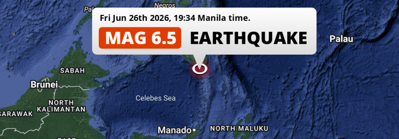
In the Sulawesi Sea 93 kilometer from General Santos, The Philippines, a strong Magnitude 6.5 earthquake occurred in the evening of Friday June 26th, 2026. Mag 6.5+ earthquakes at shallow depth under sea have the potential to cause tsunami's. Another nearby country is Indonesia.
Felt the earthquake? Share this article: 


Earthquake Summary
This earthquake hit under water in the Sulawesi Sea, 41 kilometers (25 mi) off the coast of The Philippines, 93 kilometer south of General Santos in Soccsksargen. The center of this earthquake had a quite shallow depth of 42 km. Shallow earthquakes usually have a larger impact than earthquakes deep in the earth.
| Date and Time: | Jun 26, 2026 07:34PM (Manila Time) - Jun 26, 2026 11:34 Universal Time. |
|---|---|
| Location: | 93 km south of General Santos, Soccsksargen, The Philippines. Coordinates 5°17'12"N 125°4'19"E. |
| Map: | 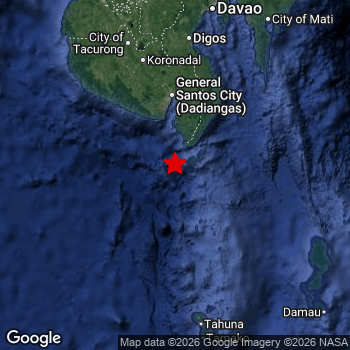 Map of area around epicenter. Click to open in Google Maps. |
| Magnitude: | MAG 6.5 Detected by 44 stations. Maximum Error Range ±0.037 . |
| Depth: | 42 km (26 mi) A quite shallow depth. |
| Max. Intensity: | VII
Very Strong On the Modified Mercalli Scale. |
| Tsunami Risk: | Potential Tsunami Risk Mag 6.5+ earthquakes at shallow depth under sea have the potential to cause tsunami's. Always stay cautious - More info here. |
Potential Tsunami Risk
There is a potential tsunami risk in the aftermath of this earthquake, immediately evacuate to higher grounds away from coastal areas and monitor advice from local authorities. This earthquake checks all the likely tsunami risk factors: under sea, at a magnitude of MAG-6.5+ and at a shallow depth.
Tsunami Risk Factors
| Factor | Under Sea? | MAG-6.5 or stronger? | Shallow depth? |
|---|---|---|---|
| Explanation | Almost all tsunami's are caused by earthquakes with their epicenter under sea or very near the sea. However stay cautious in coastal areas as earthquakes on land may cause landslides into sea, potentially still causing a local tsunami. | Under MAG 6.5: Very unlikely to cause a tsunami. MAG 6.5 to 7.5: Destructive tsunami's do occur, but are uncommon. Likely to observe small sea level changes. MAG 7.6+: Earthquakes with these magnitudes might produce destructive tsunami's. |
Most destructive tsunami's are caused by shallow earthquakes with a depth between 0 and 100km under the surface of the earth. Deeper tsunami's are unlikely to displace to ocean floor. |
| This Earthquake | This earthquake appears to have struck under the sea. | This earthquake had a magnitude of 6.5. Earthquakes of this strength could trigger a tsunami. | This earthquake occurred at a depth of of 42 km (26 mi). Earthquakes this shallow could trigger a tsunami. |
Minimal impact predicted
Based on scientific estimates by the US Geographic Survey (USGS), the risk of high fatalities for this earthquake is classified at level GREEN (low). They expect an 90% likelyhood of between 0 and 1 fatalities.
The USGS classifies the economic impact of this earthquake at level GREEN (low). They expect an 90% likelyhood of between 0 and 1 million US Dollars in economic damage and impact.
Roughly 8 million people exposed to shaking
The USGS has published a report estimating the number of people exposed to this earthquake. Acoording to their analysis, roughly 8 million have been exposed to shaking at an MMI level of II or higher.
Very strong shaking and likely moderate damage may have been experienced by an estimated 70 people. At VII, it is the highest MMI level this earthquake has caused. Intensity level IV was experienced by the majority of people (around 4.8 million). In their region, light shaking and likely no damage can be expected.
People in 2 countries have been exposed to shaking. Roughly 7.4 million people were exposed to shaking in The Philippines , with level VII (very strong shaking, likely moderate damage) as the highest recorded. Shaking was experienced by inhabitants of Indonesia too.
| People | MMI Level | Shaking | Damage |
|---|---|---|---|
| 0 | I |
Not noticable | None |
| 0 | II |
Very weak | None |
| 12,010 | III |
Weak | Probably none |
| 4,831,000 | IV |
Light | Likely none |
| 1,961,000 | V |
Moderate | Very light |
| 816,200 | VI |
Strong | Light |
| 70 | VII |
Very Strong | Moderate |
| 0 | VIII |
Severe | Moderate to heavy |
| 0 | IX |
Violent | Heavy |
| 0 | X |
Extreme | Very heavy |
Nearby towns and cities
This earthquake struck within proximity of multiple countries. The Philippines and Indonesia are both within 300km distance of its epicenter.
Glan in Soccsksargen, The Philippines is the nearest significant place from the epicenter. The earthquake occurred 62 kilometer (39 mi) south of Glan. Glan experienced an earthquake intensity (MMI Scale) of roughly VI. That level implies strong shaking and probably light damage.
Multiple large cities are in proximity of today's earthquake. General Santos is located 93 km to the north and experienced an intensity of VI (strong shaking, probably light damage). Davao is located 207 km to the north and experienced an intensity of IV (light shaking, likely no damage). Budta is located 224 km to the north (intensity unknown, possibly low).
A complete list of nearby places is included below. Estimated intensity data (MMI) sourced from a shake-map published by the US Geographic Survey is shown where available (cities without data probably experienced little impact).
Overview of nearby places
| Distance | Place | Intensity (MMI) |
|---|---|---|
| 62 km (39 mi) N from epicenter |
Glan Soccsksargen, The Philippines. |
VI
Strong |
| 80 km (50 mi) N from epicenter |
Malapatan Soccsksargen, The Philippines. |
V
Moderate |
| 93 km (58 mi) N from epicenter |
General Santos Soccsksargen, The Philippines. |
VI
Strong |
| 94 km (58 mi) N from epicenter |
Alabel Soccsksargen, The Philippines. |
V
Moderate |
| 104 km (65 mi) N from epicenter |
Polomolok Soccsksargen, The Philippines. |
V
Moderate |
| 112 km (70 mi) N from epicenter |
Lake Sebu Soccsksargen, The Philippines. |
V
Moderate |
| 113 km (70 mi) N from epicenter |
Maluñgun Soccsksargen, The Philippines. |
V
Moderate |
| 117 km (73 mi) N from epicenter |
Tupi Soccsksargen, The Philippines. |
V
Moderate |
| 126 km (78 mi) N from epicenter |
Surallah Soccsksargen, The Philippines. |
V
Moderate |
| 131 km (81 mi) N from epicenter |
Bañga Soccsksargen, The Philippines. |
V
Moderate |
| 138 km (86 mi) N from epicenter |
Koronadal Soccsksargen, The Philippines. |
V
Moderate |
| 139 km (86 mi) NE from epicenter |
Malita Davao, The Philippines. |
V
Moderate |
| 148 km (92 mi) N from epicenter |
Santa Maria Davao, The Philippines. |
IV
Light |
| 158 km (98 mi) N from epicenter |
Isulan Soccsksargen, The Philippines. |
V
Moderate |
| 162 km (101 mi) N from epicenter |
Tacurong Soccsksargen, The Philippines. |
V
Moderate |
| 162 km (101 mi) N from epicenter |
Buluan Rehiyong Autonomo sa Muslim na Mindanao, The Philippines. |
V
Moderate |
| 165 km (103 mi) N from epicenter |
Magsaysay Davao, The Philippines. |
IV
Light |
| 166 km (103 mi) N from epicenter |
Laguilayan Soccsksargen, The Philippines. |
V
Moderate |
| 166 km (103 mi) N from epicenter |
Digos Davao, The Philippines. |
IV
Light |
| 167 km (104 mi) N from epicenter |
Bansalan Davao, The Philippines. |
IV
Light |
| 189 km (117 mi) N from epicenter |
Maganoy Rehiyong Autonomo sa Muslim na Mindanao, The Philippines. |
IV
Light |
| 191 km (119 mi) N from epicenter |
Kidapawan Soccsksargen, The Philippines. |
IV
Light |
| 204 km (127 mi) N from epicenter |
Kabacan Soccsksargen, The Philippines. |
|
| 207 km (129 mi) N from epicenter |
Davao Davao, The Philippines. |
IV
Light |
| 207 km (129 mi) NE from epicenter |
Lupon Davao, The Philippines. |
IV
Light |
| 211 km (131 mi) N from epicenter |
Samal Davao, The Philippines. |
IV
Light |
| 219 km (136 mi) N from epicenter |
Malingao Soccsksargen, The Philippines. |
|
| 220 km (137 mi) N from epicenter |
Pagaluñgan Rehiyong Autonomo sa Muslim na Mindanao, The Philippines. |
|
| 220 km (137 mi) N from epicenter |
Midsayap Soccsksargen, The Philippines. |
|
| 224 km (139 mi) N from epicenter |
Budta Rehiyong Autonomo sa Muslim na Mindanao, The Philippines. |
|
| 225 km (140 mi) NE from epicenter |
Mati Davao, The Philippines. |
IV
Light |
| 234 km (145 mi) NW from epicenter |
Cotabato Rehiyong Autonomo sa Muslim na Mindanao, The Philippines. |
|
| 235 km (146 mi) N from epicenter |
Panabo Davao, The Philippines. |
|
| 248 km (154 mi) N from epicenter |
Parang Rehiyong Autonomo sa Muslim na Mindanao, The Philippines. |
|
| 254 km (158 mi) N from epicenter |
Magugpo Poblacion Davao, The Philippines. |
|
| 272 km (169 mi) N from epicenter |
Quezon Northern Mindanao, The Philippines. |
|
| 275 km (171 mi) N from epicenter |
Maramag Northern Mindanao, The Philippines. |
|
| 288 km (179 mi) N from epicenter |
Compostela Davao, The Philippines. |
|
| 291 km (181 mi) N from epicenter |
NIA Valencia Northern Mindanao, The Philippines. |
|
| 314 km (195 mi) N from epicenter |
Marawi City Rehiyong Autonomo sa Muslim na Mindanao, The Philippines. |
|
| 333 km (207 mi) NW from epicenter |
Muricay Zamboanga Peninsula, The Philippines. |
|
| 334 km (208 mi) N from epicenter |
Mantampay Northern Mindanao, The Philippines. |
|
| 335 km (208 mi) NW from epicenter |
Pagadian Zamboanga Peninsula, The Philippines. |
|
| 338 km (210 mi) N from epicenter |
Iligan City Soccsksargen, The Philippines. |
|
| 340 km (211 mi) N from epicenter |
Iligan Northern Mindanao, The Philippines. |
|
| 346 km (215 mi) NW from epicenter |
Ozamiz City Northern Mindanao, The Philippines. |
|
| 358 km (222 mi) N from epicenter |
Cagayan de Oro Northern Mindanao, The Philippines. |
|
| 377 km (234 mi) NW from epicenter |
Zamboanga Zamboanga Peninsula, The Philippines. |
|
| 409 km (254 mi) N from epicenter |
Libertad Caraga, The Philippines. |
|
| 411 km (255 mi) N from epicenter |
Butuan Caraga, The Philippines. |
|
| 424 km (263 mi) S from epicenter |
Manado North Sulawesi, Indonesia. |
|
| 488 km (303 mi) NW from epicenter |
Dumaguete Central Visayas, The Philippines. |
Earthquake Intensity Map
The graph below overlays a map of the region around the epicenter with earthquake intensity data provided by the US Geographic Survey. The highest intensity level detected for this earthquake is VII.

Shaking reported by 62 people in 2 countries
People that feel an earthquake may report their experience to the US Geographic Survey. Currently, 62 people have reported shaking in 29 places in 2 countries (Philippines, Indonesia).We keep updating this article as more ground reports become available. You may report that you felt this earthquake here.
Places with most reports:
- Buayan, Southern Mindanao, Philippines: 12 people.
- Davao, Southern Mindanao, Philippines: 6 people.
- Katangawan, Southern Mindanao, Philippines: 5 people.
- San Jose (General Santos City, South Cotabato), Southern Mindanao, Philippines: 5 people.
- Kiamba, Southern Mindanao, Philippines: 3 people.
- Bato, Southern Mindanao, Philippines: 2 people.
- Silway, Southern Mindanao, Philippines: 2 people.
- Klinan, Southern Mindanao, Philippines: 2 people.
- Digos, Southern Mindanao, Philippines: 2 people.
- Manado, Sulawesi Utara, Indonesia: 2 people.
30 Aftershocks detected
Since this main shock, 30 smaller aftershocks were detected. Just 3 days after this main shock, an earthquake measuring MAG-5.2 was detected 82 km (51 mi) south of this earthquake.
In the days before this main shock, 37 smaller foreshocks were detected. Roughly 1 day before this earthquake, a foreshock measuring MAG-4.9 was detected nearby this earthquake.
Overview of foreshocks and aftershocks
| Classification | Magnitude | When | Where |
|---|---|---|---|
| Foreshock | M 3.6 |
3 days earlier Jun 23, 2026 10:06PM (Manila Time) | 14 km (8 mi) NE from Main Shock. |
| Foreshock | M 4.2 |
3 days earlier Jun 23, 2026 10:06PM (Manila Time) | 29 km (18 mi) SW from Main Shock. |
| Foreshock | M 3.7 |
3 days earlier Jun 23, 2026 10:28PM (Manila Time) | 45 km (28 mi) SE from Main Shock. |
| Foreshock | M 4.4 |
3 days earlier Jun 23, 2026 11:19PM (Manila Time) | 32 km (20 mi) N from Main Shock. |
| Foreshock | M 3.0 |
3 days earlier Jun 23, 2026 11:27PM (Manila Time) | 54 km (34 mi) S from Main Shock. |
| Foreshock | M 3.9 |
3 days earlier Jun 23, 2026 11:47PM (Manila Time) | 41 km (25 mi) E from Main Shock. |
| Foreshock | M 3.6 |
3 days earlier Jun 24, 2026 12:58AM (Manila Time) | 76 km (47 mi) E from Main Shock. |
| Foreshock | M 3.1 |
3 days earlier Jun 24, 2026 01:27AM (Manila Time) | 3 km (1.9 mi) SW from Main Shock. |
| Foreshock | M 3.6 |
3 days earlier Jun 24, 2026 03:37AM (Manila Time) | 29 km (18 mi) SE from Main Shock. |
| Foreshock | M 3.3 |
3 days earlier Jun 24, 2026 06:30AM (Manila Time) | 57 km (36 mi) E from Main Shock. |
| Foreshock | M 3.9 |
3 days earlier Jun 24, 2026 06:33AM (Manila Time) | 92 km (57 mi) NE from Main Shock. |
| Foreshock | M 3.4 |
2 days earlier Jun 24, 2026 09:08AM (Manila Time) | 50 km (31 mi) NE from Main Shock. |
| Foreshock | M 4.8 |
2 days earlier Jun 24, 2026 11:32AM (Manila Time) | 28 km (17 mi) SW from Main Shock. |
| Foreshock | M 3.7 |
2 days earlier Jun 24, 2026 06:43PM (Manila Time) | 44 km (27 mi) E from Main Shock. |
| Foreshock | M 3.2 |
2 days earlier Jun 24, 2026 06:49PM (Manila Time) | 42 km (26 mi) S from Main Shock. |
| Foreshock | M 3.4 |
2 days earlier Jun 24, 2026 09:14PM (Manila Time) | 90 km (56 mi) NE from Main Shock. |
| Foreshock | M 4.0 |
2 days earlier Jun 24, 2026 10:28PM (Manila Time) | 39 km (24 mi) NE from Main Shock. |
| Foreshock | M 3.5 |
2 days earlier Jun 25, 2026 01:42AM (Manila Time) | 65 km (40 mi) S from Main Shock. |
| Foreshock | M 3.0 |
2 days earlier Jun 25, 2026 02:25AM (Manila Time) | 20 km (13 mi) SW from Main Shock. |
| Foreshock | M 3.3 |
2 days earlier Jun 25, 2026 05:14AM (Manila Time) | 41 km (26 mi) E from Main Shock. |
| Foreshock | M 3.7 |
2 days earlier Jun 25, 2026 05:17AM (Manila Time) | 95 km (59 mi) N from Main Shock. |
| Foreshock | M 3.1 |
1 day earlier Jun 25, 2026 07:35AM (Manila Time) | 63 km (39 mi) NE from Main Shock. |
| Foreshock | M 3.8 |
1 day earlier Jun 25, 2026 10:34AM (Manila Time) | 31 km (19 mi) E from Main Shock. |
| Foreshock | M 4.1 |
1 day earlier Jun 25, 2026 10:37AM (Manila Time) | 69 km (43 mi) SE from Main Shock. |
| Foreshock | M 3.4 |
1 day earlier Jun 25, 2026 11:29AM (Manila Time) | 27 km (17 mi) S from Main Shock. |
| Foreshock | M 4.9 |
1 day earlier Jun 25, 2026 12:03PM (Manila Time) | 22 km (14 mi) E from Main Shock. |
| Foreshock | M 3.5 |
1 day earlier Jun 25, 2026 02:08PM (Manila Time) | 73 km (45 mi) SE from Main Shock. |
| Foreshock | M 3.8 |
1 day earlier Jun 25, 2026 04:39PM (Manila Time) | 49 km (30 mi) SE from Main Shock. |
| Foreshock | M 3.1 |
1 day earlier Jun 25, 2026 06:13PM (Manila Time) | 59 km (37 mi) W from Main Shock. |
| Foreshock | M 3.9 |
1 day earlier Jun 25, 2026 07:03PM (Manila Time) | 40 km (25 mi) NE from Main Shock. |
| Foreshock | M 3.9 |
1 day earlier Jun 25, 2026 07:17PM (Manila Time) | 58 km (36 mi) E from Main Shock. |
| Foreshock | M 3.3 |
19 hrs earlier Jun 26, 2026 01:00AM (Manila Time) | 68 km (42 mi) NE from Main Shock. |
| Foreshock | M 3.8 |
18 hrs earlier Jun 26, 2026 01:42AM (Manila Time) | 22 km (13 mi) SE from Main Shock. |
| Foreshock | M 3.3 |
12 hrs earlier Jun 26, 2026 07:11AM (Manila Time) | 89 km (55 mi) NE from Main Shock. |
| Foreshock | M 3.8 |
11 hrs earlier Jun 26, 2026 08:18AM (Manila Time) | 88 km (55 mi) NE from Main Shock. |
| Foreshock | M 3.7 |
4 hrs earlier Jun 26, 2026 03:55PM (Manila Time) | 12 km (7 mi) NE from Main Shock. |
| Foreshock | M 3.3 |
3 hrs earlier Jun 26, 2026 04:11PM (Manila Time) | 45 km (28 mi) E from Main Shock. |
| Main Shock This Earthquake |
M 6.5 |
Jun 26, 2026 07:34PM (Manila Time) | - |
| Aftershock | M 3.7 |
54 mins later Jun 26, 2026 08:28PM (Manila Time) | 25 km (15 mi) NE from Main Shock. |
| Aftershock | M 4.4 |
1 hr later Jun 26, 2026 08:54PM (Manila Time) | 21 km (13 mi) NE from Main Shock. |
| Aftershock | M 4.3 |
2 hrs later Jun 26, 2026 10:02PM (Manila Time) | 36 km (22 mi) N from Main Shock. |
| Aftershock | M 3.2 |
3 hrs later Jun 26, 2026 10:07PM (Manila Time) | 60 km (37 mi) E from Main Shock. |
| Aftershock | M 3.8 |
5 hrs later Jun 27, 2026 12:21AM (Manila Time) | 38 km (23 mi) E from Main Shock. |
| Aftershock | M 4.0 |
5 hrs later Jun 27, 2026 12:28AM (Manila Time) | 33 km (21 mi) E from Main Shock. |
| Aftershock | M 3.1 |
8 hrs later Jun 27, 2026 03:48AM (Manila Time) | 25 km (16 mi) S from Main Shock. |
| Aftershock | M 4.7 |
9 hrs later Jun 27, 2026 04:08AM (Manila Time) | 57 km (36 mi) NE from Main Shock. |
| Aftershock | M 4.2 |
11 hrs later Jun 27, 2026 06:11AM (Manila Time) | 34 km (21 mi) SW from Main Shock. |
| Aftershock | M 3.9 |
11 hrs later Jun 27, 2026 06:11AM (Manila Time) | 34 km (21 mi) E from Main Shock. |
| Aftershock | M 3.6 |
14 hrs later Jun 27, 2026 09:32AM (Manila Time) | 28 km (17 mi) E from Main Shock. |
| Aftershock | M 4.0 |
15 hrs later Jun 27, 2026 10:22AM (Manila Time) | 40 km (25 mi) W from Main Shock. |
| Aftershock | M 3.1 |
16 hrs later Jun 27, 2026 11:10AM (Manila Time) | 48 km (30 mi) NW from Main Shock. |
| Aftershock | M 3.8 |
21 hrs later Jun 27, 2026 04:56PM (Manila Time) | 52 km (32 mi) E from Main Shock. |
| Aftershock | M 3.6 |
1 day later Jun 27, 2026 08:53PM (Manila Time) | 51 km (32 mi) NE from Main Shock. |
| Aftershock | M 3.7 |
2 days later Jun 28, 2026 08:32AM (Manila Time) | 38 km (23 mi) E from Main Shock. |
| Aftershock | M 3.2 |
2 days later Jun 28, 2026 08:37AM (Manila Time) | 48 km (30 mi) NE from Main Shock. |
| Aftershock | M 4.2 |
2 days later Jun 28, 2026 01:04PM (Manila Time) | 12 km (8 mi) NE from Main Shock. |
| Aftershock | M 3.0 |
2 days later Jun 28, 2026 03:18PM (Manila Time) | 43 km (27 mi) SE from Main Shock. |
| Aftershock | M 3.8 |
2 days later Jun 28, 2026 04:29PM (Manila Time) | 31 km (19 mi) NE from Main Shock. |
| Aftershock | M 3.9 |
2 days later Jun 29, 2026 01:37AM (Manila Time) | 64 km (40 mi) E from Main Shock. |
| Aftershock | M 4.5 |
2 days later Jun 29, 2026 01:57AM (Manila Time) | 53 km (33 mi) NE from Main Shock. |
| Aftershock | M 3.3 |
2 days later Jun 29, 2026 02:54AM (Manila Time) | 96 km (60 mi) SE from Main Shock. |
| Aftershock | M 3.2 |
2 days later Jun 29, 2026 03:38AM (Manila Time) | 45 km (28 mi) NE from Main Shock. |
| Aftershock | M 3.0 |
2 days later Jun 29, 2026 04:44AM (Manila Time) | 53 km (33 mi) NE from Main Shock. |
| Aftershock | M 3.0 |
3 days later Jun 29, 2026 09:35AM (Manila Time) | 4 km (2.6 mi) S from Main Shock. |
| Aftershock | M 4.9 |
3 days later Jun 29, 2026 12:14PM (Manila Time) | 87 km (54 mi) S from Main Shock. |
| Aftershock | M 5.2 |
3 days later Jun 29, 2026 12:23PM (Manila Time) | 82 km (51 mi) S from Main Shock. |
| Aftershock | M 3.8 |
3 days later Jun 29, 2026 01:04PM (Manila Time) | 72 km (45 mi) SE from Main Shock. |
| Aftershock | M 4.4 |
3 days later Jun 29, 2026 04:33PM (Manila Time) | 7 km (4 mi) NE from Main Shock. |
More earthquakes coming?
Aftershocks are usually at least 1 order of magnitude less strong than main shocks. The more time passes, the smaller the chance and likely strength of any potential aftershocks.
It's always adviced to be cautious of the risk of a larger shock following any significant earthquake, however this risk is fairly small. There is a roughly 94 percent change that no larger main shock will follow in the days following this earthquake.
Read: How to Stay Safe during an Earthquake (cdc.gov).Earthquakes like this happen often in the region
Earthquakes of this strength are very common in the region. This is the strongest earthquake to hit since June 8th, 2026, when a 6.5 magnitude earthquake hit 26 km (16 mi) further north-east. An even stronger magnitude 7.8 earthquake struck on June 7th, 2026.
In total, 15 earthquakes with a magnitude of 6.5 or higher have been registered within 300km (186 mi) of this epicenter in the past 10 years. This comes down to an average of once every 8 months.
Sources
Last updated 26/07/26 01:58 (). This article contains currently available information about the earthquake and is automatically composed. We continue to update this article up to a few days after the earthquake occurred.
- US Geographic Society (USGS): Earthquake us6000t8ec
- European-Mediterranean Seismological Centre (EMSC): Earthquake 20260626_0000151
- Geonames.org: World Cities Database
- Google Maps: Static API
- Earthquakelist.org: Historic Earthquakes Database
Share this article:
