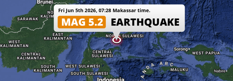
In the morning of Friday June 5th, 2026, a significant MAG-5.2 earthquake hit in the Gulf Of Tomini 73 kilometer from Gorontalo, Indonesia.
Felt the earthquake? Share this article: 


Earthquake Summary
This earthquake hit under water in the Gulf Of Tomini, 50 kilometers (31 mi) off the coast of Indonesia, 73 kilometer south of Gorontalo. The center of this earthquake had an intermediate depth of 134 km.
| Date and Time: | Jun 5, 2026 07:28 (Makassar Time) - Jun 4, 2026 23:28 Universal Time. |
|---|---|
| Location: | 73 km south of Gorontalo, Indonesia. Coordinates 0°6'57"N 122°59'11"E. |
| Map: | 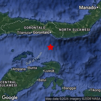 Map of area around epicenter. Click to open in Google Maps. |
| Magnitude: | MAG 5.2 Detected by 10 stations. Maximum Error Range ±0.098 . |
| Depth: | 134 km (83 mi) An intermediate depth. |
| Tsunami Risk: | Tsunami very unlikely Earthquakes under MAG-6.5 at depths deeper than 100km are very unlikely to cause tsunami's. Always stay cautious - More info here. |
Nearby towns and cities
This earthquake may have been felt in Indonesia . Located 73 kilometer (45 mi) south of the epicenter of this earthquake, Gorontalo (Gorontalo, Indonesia) is the nearest significant population center.
The table below provides an overview of all places in proximity of today's earthquake.
Overview of nearby places
| Distance | Place |
|---|---|
| 73 km (45 mi) N from epicenter |
Gorontalo Gorontalo, Indonesia. |
| 96 km (60 mi) S from epicenter |
Luwuk Central Sulawesi, Indonesia. |
| 257 km (160 mi) NE from epicenter |
Tomohon North Sulawesi, Indonesia. |
| 266 km (165 mi) NE from epicenter |
Tondano North Sulawesi, Indonesia. |
| 273 km (170 mi) NE from epicenter |
Manado North Sulawesi, Indonesia. |
| 286 km (178 mi) SW from epicenter |
Poso Central Sulawesi, Indonesia. |
6 Aftershocks detected
Since this main shock, 6 smaller aftershocks were detected. A 3.1 magnitude earthquake hit 1 hr later 72 km (45 mi) north of this earthquake.
This main shock was prefaced by 6 smaller foreshocks. Nearby this earthquake a foreshock struck 13 hrs earlier. It measured a magnitude of 3.4
Overview of foreshocks and aftershocks
| Classification | Magnitude | When | Where |
|---|---|---|---|
| Foreshock | M 2.5 |
3 days earlier Jun 2, 2026 12:00 (Makassar Time) | 16 km (10 mi) SE from Main Shock. |
| Foreshock | M 2.8 |
3 days earlier Jun 2, 2026 17:01 (Makassar Time) | 28 km (18 mi) E from Main Shock. |
| Foreshock | M 2.7 |
2 days earlier Jun 3, 2026 00:14 (Makassar Time) | 83 km (52 mi) SW from Main Shock. |
| Foreshock | M 2.5 |
2 days earlier Jun 3, 2026 01:22 (Makassar Time) | 45 km (28 mi) E from Main Shock. |
| Foreshock | M 2.5 |
1 day earlier Jun 4, 2026 04:29 (Makassar Time) | 67 km (42 mi) SE from Main Shock. |
| Foreshock | M 3.4 |
13 hrs earlier Jun 4, 2026 18:11 (Makassar Time) | 81 km (50 mi) E from Main Shock. |
| Main Shock This Earthquake |
M 5.2 |
Jun 5, 2026 07:28 (Makassar Time) | - |
| Aftershock | M 3.1 |
1 hr later Jun 5, 2026 08:58 (Makassar Time) | 72 km (45 mi) N from Main Shock. |
| Aftershock | M 3.0 |
8 hrs later Jun 5, 2026 15:09 (Makassar Time) | 17 km (11 mi) E from Main Shock. |
| Aftershock | M 3.0 |
11 hrs later Jun 5, 2026 18:25 (Makassar Time) | 76 km (47 mi) S from Main Shock. |
| Aftershock | M 2.7 |
2 days later Jun 6, 2026 23:07 (Makassar Time) | 53 km (33 mi) SW from Main Shock. |
| Aftershock | M 2.9 |
2 days later Jun 7, 2026 17:46 (Makassar Time) | 35 km (22 mi) SE from Main Shock. |
| Aftershock | M 2.7 |
3 days later Jun 8, 2026 05:49 (Makassar Time) | 57 km (35 mi) NE from Main Shock. |
More earthquakes coming?
The risk of aftershocks decreases rapidly over time. Usually, aftershocks are at least one order of magnitude lower than a main shock.
The chance that a significant earthquake like this one is followed by an even larger earthquake is not so large. On average, scientists estimate a 94% chance that a major earthquake will not be followed by an even larger one. It is still adviced to be aware of this risk
Read: How to Stay Safe during an Earthquake (cdc.gov).Earthquakes like this happen often in the region
Earthquakes of this strength are very common in the region. This is the strongest earthquake to hit since February 19th, 2026, when a 5.5 magnitude earthquake hit 194 km (121 mi) further northwest. An even stronger magnitude 6.8 earthquake struck on April 12th, 2019.
In total, 60 earthquakes with a magnitude of 5.2 or higher have been registered within 300km (186 mi) of this epicenter in the past 10 years. This comes down to an average of once every 2 months.
Tsunami very unlikely
For a serious tsunami to occur, earthquakes usually need to have a magnitude of at least 6.5 and occur at a shallow depth of maximum 100km. Neither are the case with this earthquake. However always stay cautious and monitor advice from local authorities.
Tsunami Risk Factors
| Factor | Under Sea? | MAG-6.5 or stronger? | Shallow depth? |
|---|---|---|---|
| Explanation | Almost all tsunami's are caused by earthquakes with their epicenter under sea or very near the sea. However stay cautious in coastal areas as earthquakes on land may cause landslides into sea, potentially still causing a local tsunami. | Under MAG 6.5: Very unlikely to cause a tsunami. MAG 6.5 to 7.5: Destructive tsunami's do occur, but are uncommon. Likely to observe small sea level changes. MAG 7.6+: Earthquakes with these magnitudes might produce destructive tsunami's. |
Most destructive tsunami's are caused by shallow earthquakes with a depth between 0 and 100km under the surface of the earth. Deeper tsunami's are unlikely to displace to ocean floor. |
| This Earthquake | This earthquake appears to have struck under the sea. | Not this earthquake. This earthquake had a magnitude of 5.2. Earthquakes of this strength are unlikely to trigger a tsunami. |
Not this earthquake. This earthquake occurred at a depth of 134 km (83 mi). Earthquakes this deep in the earth are unlikely to trigger a tsunami. |
Sources
Last updated 01/07/26 02:08 (). This article is automatically generated based on available data. We keep checking multiple sources for additional information. This article gets updated as new details on this earthquake become available.
- US Geographic Society (USGS): Earthquake us7000sqrh
- European-Mediterranean Seismological Centre (EMSC): Earthquake 20260604_0000360
- Geonames.org: World Cities Database
- Google Maps: Static API
- Earthquakelist.org: Historic Earthquakes Database
Share this article:
