A shallow and significant Magnitude 5.0 aftershock struck in the Maluku Sea 158 kilometer from Manado, Indonesia in the afternoon of Wednesday May 27th, 2026.
Felt the earthquake? Share this article: 


Earthquake Summary
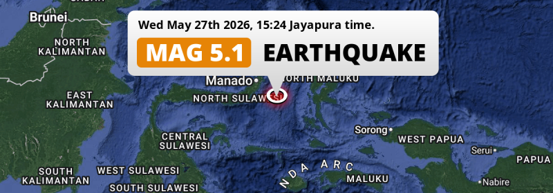
This earthquake hit under water in the Maluku Sea, 118 kilometers (74 mi) off the coast of Indonesia, 158 kilometer south-east of Manado in North Sulawesi. The center of this earthquake had a very shallow depth of 23 km. Shallow earthquakes usually have a larger impact than earthquakes deep in the earth.
| Date and Time: | May 27, 2026 14:24 (Makassar Time) - May 27, 2026 06:24 Universal Time. |
|---|---|
| Location: | 158 km SE of Manado, North Sulawesi, Indonesia. Coordinates 0°28'31"N 125°51'11"E. |
| Map: | 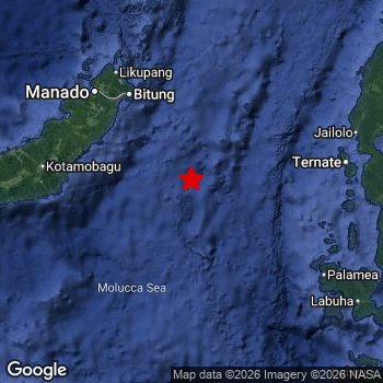 Map of area around epicenter. Click to open in Google Maps. |
| Magnitude: | MAG 5.0 Detected by 93 stations. Maximum Error Range ±0.059 . |
| Depth: | 23 km (14 mi) A very shallow depth. |
| Tsunami Risk: | Low tsunami risk Earthquakes under MAG-6.5 do not usually cause tsunami's. Always stay cautious - More info here. |
Nearby towns and cities
This earthquake may have been felt in Indonesia . Located 139 kilometer (86 mi) south-east of the epicenter of this earthquake, Tondano (North Sulawesi, Indonesia) is the nearest significant population center.
The table below provides an overview of all places in proximity of today's earthquake.
Overview of nearby places
| Distance | Place |
|---|---|
| 139 km (86 mi) NW from epicenter |
Tondano North Sulawesi, Indonesia. |
| 150 km (93 mi) NW from epicenter |
Tomohon North Sulawesi, Indonesia. |
| 158 km (98 mi) NW from epicenter |
Manado North Sulawesi, Indonesia. |
| 174 km (108 mi) E from epicenter |
Ternate North Maluku, Indonesia. |
| 192 km (119 mi) E from epicenter |
Sofifi North Maluku, Indonesia. |
Shaking reported by 1 person
People that feel an earthquake may report their experience to the US Geographic Survey. Currently, 1 person has reported shaking in one place in Indonesia.We keep updating this article as more ground reports become available. You may report that you felt this earthquake here.
Places with most reports:
- Manado, Sulawesi Utara, Indonesia: 1 person.
This is likely an aftershock
This earthquake is likely an aftershock of the MAG-5.6 earthquake that struck 1 day earlier. That main earthquake hit 71 km (44 mi) north of the epicenter of this MAG-5.0 aftershock.
Overview of foreshocks and aftershocks
| Classification | Magnitude | When | Where |
|---|---|---|---|
| Foreshock | M 3.2 |
3 days earlier May 23, 2026 09:46 (Makassar Time) | 13 km (8 mi) NE from Main Shock. |
| Foreshock | M 4.3 |
3 days earlier May 23, 2026 10:52 (Makassar Time) | 17 km (11 mi) E from Main Shock. |
| Foreshock | M 2.8 |
3 days earlier May 23, 2026 11:26 (Makassar Time) | 37 km (23 mi) N from Main Shock. |
| Foreshock | M 3.3 |
3 days earlier May 23, 2026 12:42 (Makassar Time) | 38 km (24 mi) N from Main Shock. |
| Foreshock | M 3.4 |
3 days earlier May 23, 2026 13:06 (Makassar Time) | 93 km (58 mi) E from Main Shock. |
| Foreshock | M 2.9 |
3 days earlier May 23, 2026 13:34 (Makassar Time) | 5 km (3 mi) SW from Main Shock. |
| Foreshock | M 2.8 |
2 days earlier May 23, 2026 20:20 (Makassar Time) | 46 km (28 mi) NE from Main Shock. |
| Foreshock | M 3.2 |
2 days earlier May 23, 2026 21:30 (Makassar Time) | 7 km (4 mi) S from Main Shock. |
| Foreshock | M 3.0 |
2 days earlier May 23, 2026 21:31 (Makassar Time) | 55 km (34 mi) NE from Main Shock. |
| Foreshock | M 2.6 |
2 days earlier May 23, 2026 21:38 (Makassar Time) | 13 km (8 mi) SE from Main Shock. |
| Foreshock | M 3.2 |
2 days earlier May 23, 2026 22:41 (Makassar Time) | 14 km (8 mi) E from Main Shock. |
| Foreshock | M 3.1 |
2 days earlier May 24, 2026 02:42 (Makassar Time) | 14 km (9 mi) E from Main Shock. |
| Foreshock | M 4.0 |
2 days earlier May 24, 2026 03:49 (Makassar Time) | 13 km (8 mi) SE from Main Shock. |
| Foreshock | M 2.7 |
2 days earlier May 24, 2026 06:33 (Makassar Time) | 87 km (54 mi) E from Main Shock. |
| Foreshock | M 3.1 |
2 days earlier May 24, 2026 07:43 (Makassar Time) | 42 km (26 mi) NE from Main Shock. |
| Foreshock | M 3.3 |
2 days earlier May 24, 2026 09:00 (Makassar Time) | 43 km (27 mi) NE from Main Shock. |
| Foreshock | M 2.8 |
2 days earlier May 24, 2026 14:03 (Makassar Time) | 54 km (34 mi) N from Main Shock. |
| Foreshock | M 3.0 |
2 days earlier May 24, 2026 15:32 (Makassar Time) | 67 km (42 mi) NE from Main Shock. |
| Foreshock | M 2.7 |
1 day earlier May 24, 2026 17:54 (Makassar Time) | 69 km (43 mi) NE from Main Shock. |
| Foreshock | M 2.6 |
1 day earlier May 24, 2026 19:19 (Makassar Time) | 5 km (3 mi) E from Main Shock. |
| Foreshock | M 3.0 |
1 day earlier May 24, 2026 23:04 (Makassar Time) | 47 km (29 mi) NE from Main Shock. |
| Foreshock | M 4.9 |
1 day earlier May 24, 2026 23:33 (Makassar Time) | 6 km (4 mi) SW from Main Shock. |
| Foreshock | M 3.3 |
1 day earlier May 25, 2026 00:43 (Makassar Time) | 14 km (9 mi) SE from Main Shock. |
| Foreshock | M 2.7 |
1 day earlier May 25, 2026 01:47 (Makassar Time) | 18 km (11 mi) S from Main Shock. |
| Foreshock | M 2.6 |
1 day earlier May 25, 2026 02:47 (Makassar Time) | 5 km (3 mi) S from Main Shock. |
| Foreshock | M 2.7 |
1 day earlier May 25, 2026 03:04 (Makassar Time) | 93 km (58 mi) S from Main Shock. |
| Foreshock | M 3.3 |
14 hrs earlier May 25, 2026 14:47 (Makassar Time) | 46 km (28 mi) W from Main Shock. |
| Foreshock | M 3.2 |
13 hrs earlier May 25, 2026 15:41 (Makassar Time) | 53 km (33 mi) NE from Main Shock. |
| Foreshock | M 2.7 |
9 hrs earlier May 25, 2026 20:04 (Makassar Time) | 44 km (27 mi) NE from Main Shock. |
| Foreshock | M 3.7 |
8 hrs earlier May 25, 2026 20:12 (Makassar Time) | 73 km (45 mi) E from Main Shock. |
| Foreshock | M 3.2 |
8 hrs earlier May 25, 2026 20:53 (Makassar Time) | 45 km (28 mi) NW from Main Shock. |
| Main Shock | M 5.6 |
May 26, 2026 04:39 (Makassar Time) | - |
| Aftershock | M 3.1 |
1 hr later May 26, 2026 05:47 (Makassar Time) | 11 km (7 mi) E from Main Shock. |
| Aftershock | M 3.0 |
2 hrs later May 26, 2026 06:38 (Makassar Time) | 38 km (24 mi) E from Main Shock. |
| Aftershock | M 3.1 |
3 hrs later May 26, 2026 07:53 (Makassar Time) | 53 km (33 mi) NE from Main Shock. |
| Aftershock | M 2.8 |
9 hrs later May 26, 2026 13:25 (Makassar Time) | 45 km (28 mi) NE from Main Shock. |
| Aftershock | M 3.1 |
9 hrs later May 26, 2026 13:43 (Makassar Time) | 13 km (8 mi) SE from Main Shock. |
| Aftershock | M 3.2 |
1 day later May 27, 2026 11:17 (Makassar Time) | 53 km (33 mi) NE from Main Shock. |
| Aftershock | M 2.9 |
1 day later May 27, 2026 11:20 (Makassar Time) | 46 km (28 mi) NE from Main Shock. |
| Aftershock | M 4.2 |
1 day later May 27, 2026 11:22 (Makassar Time) | 20 km (12 mi) NW from Main Shock. |
| Aftershock | M 3.5 |
1 day later May 27, 2026 11:22 (Makassar Time) | 49 km (31 mi) NE from Main Shock. |
| Aftershock This Earthquake |
M 5.0 |
1 day later May 27, 2026 14:24 (Makassar Time) | 71 km (44 mi) S from Main Shock. |
| Aftershock | M 3.1 |
1 day later May 27, 2026 15:20 (Makassar Time) | 50 km (31 mi) NE from Main Shock. |
| Aftershock | M 3.0 |
1 day later May 27, 2026 16:10 (Makassar Time) | 10 km (6 mi) E from Main Shock. |
| Aftershock | M 3.2 |
2 days later May 27, 2026 17:23 (Makassar Time) | 91 km (56 mi) E from Main Shock. |
| Aftershock | M 3.0 |
2 days later May 27, 2026 19:35 (Makassar Time) | 84 km (52 mi) SE from Main Shock. |
| Aftershock | M 2.8 |
2 days later May 27, 2026 19:43 (Makassar Time) | 30 km (19 mi) E from Main Shock. |
| Aftershock | M 2.7 |
2 days later May 27, 2026 20:17 (Makassar Time) | 11 km (7 mi) E from Main Shock. |
| Aftershock | M 3.2 |
2 days later May 28, 2026 04:57 (Makassar Time) | 82 km (51 mi) S from Main Shock. |
| Aftershock | M 2.5 |
2 days later May 28, 2026 05:14 (Makassar Time) | 48 km (30 mi) NE from Main Shock. |
| Aftershock | M 2.5 |
2 days later May 28, 2026 06:39 (Makassar Time) | 83 km (52 mi) E from Main Shock. |
| Aftershock | M 3.8 |
2 days later May 28, 2026 12:34 (Makassar Time) | 6 km (4 mi) SE from Main Shock. |
| Aftershock | M 4.3 |
2 days later May 28, 2026 16:33 (Makassar Time) | 26 km (16 mi) NE from Main Shock. |
| Aftershock | M 2.9 |
3 days later May 28, 2026 20:51 (Makassar Time) | 51 km (32 mi) NE from Main Shock. |
| Aftershock | M 2.7 |
3 days later May 28, 2026 21:35 (Makassar Time) | 47 km (29 mi) NE from Main Shock. |
| Aftershock | M 3.0 |
3 days later May 29, 2026 00:40 (Makassar Time) | 39 km (24 mi) SE from Main Shock. |
| Aftershock | M 2.5 |
3 days later May 29, 2026 04:31 (Makassar Time) | 95 km (59 mi) E from Main Shock. |
| Aftershock | M 2.5 |
3 days later May 29, 2026 05:03 (Makassar Time) | 96 km (60 mi) NE from Main Shock. |
| Aftershock | M 3.5 |
3 days later May 29, 2026 07:14 (Makassar Time) | 45 km (28 mi) NW from Main Shock. |
| Aftershock | M 3.1 |
4 days later May 29, 2026 16:55 (Makassar Time) | 80 km (50 mi) S from Main Shock. |
| Aftershock | M 4.7 |
4 days later May 29, 2026 18:04 (Makassar Time) | 11 km (7 mi) SE from Main Shock. |
| Aftershock | M 3.6 |
4 days later May 29, 2026 18:04 (Makassar Time) | 35 km (22 mi) E from Main Shock. |
| Aftershock | M 2.9 |
4 days later May 29, 2026 23:33 (Makassar Time) | 35 km (22 mi) NE from Main Shock. |
| Aftershock | M 3.7 |
4 days later May 30, 2026 00:16 (Makassar Time) | 46 km (29 mi) NW from Main Shock. |
| Aftershock | M 2.9 |
4 days later May 30, 2026 00:53 (Makassar Time) | 44 km (27 mi) NW from Main Shock. |
| Aftershock | M 3.6 |
4 days later May 30, 2026 04:09 (Makassar Time) | 89 km (55 mi) NE from Main Shock. |
| Aftershock | M 2.9 |
4 days later May 30, 2026 09:19 (Makassar Time) | 99 km (61 mi) E from Main Shock. |
| Aftershock | M 3.0 |
4 days later May 30, 2026 11:08 (Makassar Time) | 74 km (46 mi) NE from Main Shock. |
More earthquakes coming?
Earthquakes can create aftershocks. These are generally at least 1 magnitude lower than any main shock, and as time passes the chance and strength of aftershocks decreases.
The chance that a significant earthquake like this one is followed by an even larger earthquake is not so large. On average, scientists estimate a 94% chance that a major earthquake will not be followed by an even larger one. It is still adviced to be aware of this risk
Read: How to Stay Safe during an Earthquake (cdc.gov).Earthquakes like this happen often in the region
Earthquakes of this strength are very common in the region. In total, 386 earthquakes with a magnitude of 5 or higher have been registered within 300km (186 mi) of this epicenter in the past 10 years. This comes down to an average of once every 9 days.
Low tsunami risk
Based on early data it appears this earthquake was not strong enough (lower than MAG-6.5) to be likely to cause destructive tsunami's. However this earthquake appeared to have hit at a shallow depth under sea, so stay cautious and monitor advice from local authorities.
Tsunami Risk Factors
| Factor | Under Sea? | MAG-6.5 or stronger? | Shallow depth? |
|---|---|---|---|
| Explanation | Almost all tsunami's are caused by earthquakes with their epicenter under sea or very near the sea. However stay cautious in coastal areas as earthquakes on land may cause landslides into sea, potentially still causing a local tsunami. | Under MAG 6.5: Very unlikely to cause a tsunami. MAG 6.5 to 7.5: Destructive tsunami's do occur, but are uncommon. Likely to observe small sea level changes. MAG 7.6+: Earthquakes with these magnitudes might produce destructive tsunami's. |
Most destructive tsunami's are caused by shallow earthquakes with a depth between 0 and 100km under the surface of the earth. Deeper tsunami's are unlikely to displace to ocean floor. |
| This Earthquake | This earthquake appears to have struck under the sea. | Not this earthquake. This earthquake had a magnitude of 5. Earthquakes of this strength are unlikely to trigger a tsunami. |
This earthquake occurred at a depth of of 23 km (14 mi). Earthquakes this shallow could trigger a tsunami. |
Sources
Last updated 20/06/26 01:18 (). As more information on this earthquake becomes available this article will be updated. This article is automatically composed based on data originating from multiple sources.
- US Geographic Society (USGS): Earthquake us7000sntr
- European-Mediterranean Seismological Centre (EMSC): Earthquake 20260527_0000097
- Geonames.org: World Cities Database
- Google Maps: Static API
- Earthquakelist.org: Historic Earthquakes Database
Share this article:
