 Read this article


Latest earthquakes near The Philippines today
Complete overview of the latest earthquakes near the country The Philippines, updated every minute. Did you feel an earthquake today in The Philippines? If an earthquake is happening right now near The Philippines, it will show up within minutes.
Recent The Philippines Earthquake News
These are the latest articles published related to earthquakes occurring near The Philippines. Check our Earthquake News section for a complete overview of articles written on earthquakes near The Philippines and elsewhere.
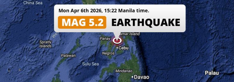
 Apr 6, 2026 03:22PM
On Monday Afternoon a Shallow M5.2 Earthquake struck near Cebu City in The Philippines.
Apr 6, 2026 03:22PM
On Monday Afternoon a Shallow M5.2 Earthquake struck near Cebu City in The Philippines.
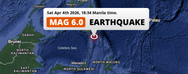 Apr 4, 2026 06:34PM
On Saturday Evening a Strong M6.0 Earthquake struck in the Philippine Sea 171km from General Santos (The Philippines).
Apr 4, 2026 06:34PM
On Saturday Evening a Strong M6.0 Earthquake struck in the Philippine Sea 171km from General Santos (The Philippines).
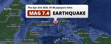 Apr 2, 2026 06:48AM
Unusually powerful M7.4 Earthquake hit in the Maluku Sea 166km from Manado (Indonesia) on Thursday Morning.
Apr 2, 2026 06:48AM
Unusually powerful M7.4 Earthquake hit in the Maluku Sea 166km from Manado (Indonesia) on Thursday Morning.
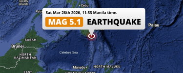 Mar 28, 2026 11:33AM
Significant M5.1 Earthquake struck on Saturday Morning in the Philippine Sea near General Santos (The Philippines).
Mar 28, 2026 11:33AM
Significant M5.1 Earthquake struck on Saturday Morning in the Philippine Sea near General Santos (The Philippines).
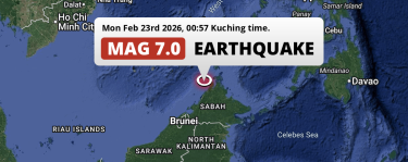 Feb 23, 2026 12:57AM
On Monday Night an Unusually powerful M7.0 Earthquake struck in the South China Sea near Kota Kinabalu (Malaysia).
Feb 23, 2026 12:57AM
On Monday Night an Unusually powerful M7.0 Earthquake struck in the South China Sea near Kota Kinabalu (Malaysia).
 Jan 28, 2026 02:47PM
On Wednesday Afternoon a Shallow M5.9 Earthquake struck in the Sulawesi Sea 111km from Malingao (The Philippines).
Jan 28, 2026 02:47PM
On Wednesday Afternoon a Shallow M5.9 Earthquake struck in the Sulawesi Sea 111km from Malingao (The Philippines).
The Philippines Earthquake Statistics
Average
A total of 8730 earthquakes with a magnitude of four or above have struck within 300 km (186 mi) of The Philippines in the past 10 years. This comes down to a yearly average of 873 earthquakes per year, or 72 per month. On average an earthquake will hit near The Philippines roughly every 10 hours.
A relatively large number of earthquakes occurred near The Philippines in 2023. A total of 1470 earthquakes (mag 4+) were detected within 300 km of The Philippines that year. The strongest had a 7.6 magnitude.

Magnitude Distribution
The table below visualizes the distribution of all earthquakes that occurred within 300km of The Philippines in the past 10 years. No earthquakes with a magnitude of 8 or above have occurred near The Philippines during this time. Usually, higher magnitudes are less common than lower magnitudes. Small earthquakes with a magnitude below 4 on the Richter scale have been omitted from this overview.
| Magnitude | Earthquakes | Percentage |
|---|---|---|
| Mag. 4 | 7903 | 90.53% |
| Mag. 5 | 756 | 8.66% |
| Mag. 6 | 63 | 0.72% |
| Mag. 7 | 8 | 0.09% |
| Mag. 8 | 0 | 0.0% |
| Mag. 9 | 0 | 0.0% |
| Mag. 10 | 0 | 0.0% |
Strongest earthquakes near The Philippines
The strongest recent earthquake of the past 10 years near The Philippines occurred on Dec 2, 2023 22:37 local time (Asia/Manila timezone). It had a magnitude of 7.6 and struck 184 kilometers (114 mi) north-northeast of Davao, at a depth of 40 km. Discover more strong earthquakes near The Philippines in the list below.
A longer time ago, a MAG-8.3 earthquake struck on Aug 15, 1918 20:18, 145 kilometers (90 mi) north-northeast of General Santos. It is the strongest earthquake near The Philippines in the past 126 years (Our data goes back to January 1st, 1900).
In the table below you will find the strongest earthquakes that occurred near The Philippines in the past 10 years. You can use the tabs to find the heaviest historic earthquakes since the year 1900 or within a specific year or distance from The Philippines.
Earthquakes by region of The Philippines
Click the links below for earthquake reports for regions in The Philippines.
- Bicol
- Cagayan Valley (Lambak ng Cagayan)
- Calabarzon
- Caraga
- Central Luzon (Gitnang Luzon)
- Central Visayas (Gitnang Kabisayaan)
- Cordillera (Rehiyong Pampangasiwaan ng Cordillera)
- Davao
- Eastern Visayas (Silangang Kabisayaan)
- Ilocos
- Mimaropa
- National Capital Region (Metro Manila)
- Northern Mindanao (Hilagang Mindanao)
- Rehiyong Autonomo sa Muslim na Mindanao
- Soccsksargen
- Western Visayas (Kanlurang Kabisayaan)
- Zamboanga Peninsula
Frequently Asked Questions
These questions are commonly asked in relation to earthquakes occurring near The Philippines.
When was the last earthquake in The Philippines?
A 5.2 magnitude earthquake hit near The Philippines on the afternoon of April 6, 2026 at 15:22 local time (Asia/Manila). The center of this earthquake was located 59km north of Cebu City at a depth of 10km under land. Check the list on our website for any earthquakes occurring near The Philippines in the past hours.
What was the strongest earthquake near The Philippines?
A 8.3 magnitude earthquake hit near The Philippines on the evening of August 15, 1918 at 20:18 local time (Asia/Manila). The center of this earthquake was located 145km west-southwest of General Santos at a depth of 20km under water in the Sulawesi Sea. This is the strongest earthquake that occurred near The Philippines since the year 1900.
How often do earthquakes occur near The Philippines?
In the past 10 years, 8730 earthquakes with a magnitude of four or higher occurred within a 300 kilometer range from The Philippines. This averages to 873 earthquakes yearly, or one earthquake every 10 hours.
