Latest earthquakes near Colombia today
Complete overview of the latest earthquakes near the country Colombia, updated every minute. Did you feel an earthquake today in Colombia? If an earthquake is happening right now near Colombia, it will show up within minutes.
Recent Colombia Earthquake News
These are the latest articles published related to earthquakes occurring near Colombia. Check our Earthquake News section for a complete overview of articles written on earthquakes near Colombia and elsewhere.
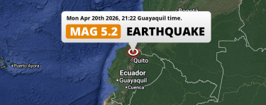 Apr 20, 2026 09:22PM
Significant M5.2 Earthquake struck on Monday Evening near Ibarra in Ecuador.
Apr 20, 2026 09:22PM
Significant M5.2 Earthquake struck on Monday Evening near Ibarra in Ecuador.
Colombia Earthquake Statistics
Average
A total of 1523 earthquakes with a magnitude of four or above have struck within 300 km (186 mi) of Colombia in the past 10 years. This comes down to a yearly average of 152 earthquakes per year, or 12 per month. On average an earthquake will hit near Colombia roughly every 2 days.
A relatively large number of earthquakes occurred near Colombia in 2016. A total of 206 earthquakes (mag 4+) were detected within 300 km of Colombia that year. The strongest had a 6.9 magnitude.

Magnitude Distribution
The table below visualizes the distribution of all earthquakes that occurred within 300km of Colombia in the past 10 years. No earthquakes with a magnitude of 7 or above have occurred near Colombia during this time. Usually, higher magnitudes are less common than lower magnitudes. Small earthquakes with a magnitude below 4 on the Richter scale have been omitted from this overview.
| Magnitude | Earthquakes | Percentage |
|---|---|---|
| Mag. 4 | 1414 | 92.84% |
| Mag. 5 | 97 | 6.37% |
| Mag. 6 | 12 | 0.79% |
| Mag. 7 | 0 | 0.0% |
| Mag. 8 | 0 | 0.0% |
| Mag. 9 | 0 | 0.0% |
| Mag. 10 | 0 | 0.0% |
Strongest earthquakes near Colombia
The strongest recent earthquake of the past 10 years near Colombia occurred on May 18, 2016 11:46 local time (America/Bogota timezone). It had a magnitude of 6.9 and struck 272 kilometers (169 mi) west-southwest of Pasto, at a depth of 30 km. Discover more strong earthquakes near Colombia in the list below.
A longer time ago, a MAG-8.8 earthquake struck on Jan 31, 1906 10:39, 234 kilometers (145 mi) west-southwest of Pasto. It is the strongest earthquake near Colombia in the past 126 years (Our data goes back to January 1st, 1900).
In the table below you will find the strongest earthquakes that occurred near Colombia in the past 10 years. You can use the tabs to find the heaviest historic earthquakes since the year 1900 or within a specific year or distance from Colombia.
Earthquakes by region of Colombia
Click the links below for earthquake reports for regions in Colombia.
- Amazonas
- Antioquia (Departamento de Antioquia)
- Atlántico
- Bogota D.C. (Bogotá D.C.)
- Bolívar
- Boyacá
- Caldas
- Caquetá
- Casanare
- Cauca
- Cesar
- Chocó
- Cundinamarca
- Córdoba
- Departamento de Arauca (Arauca)
- Guaviare
- Huila
- La Guajira
- Magdalena
- Meta
- Nariño
- Norte de Santander
- Putumayo
- Quindío (Departamento del Quindío)
- Risaralda
- San Andres y Providencia (San Andrés y Providencia)
- Santander
- Sucre
- Tolima
- Valle del Cauca
- Vichada
Frequently Asked Questions
These questions are commonly asked in relation to earthquakes occurring near Colombia.
When was the last earthquake in Colombia?
A 3.9 magnitude earthquake hit near Colombia on the night of April 25, 2026 at 04:37 local time (America/Bogota). The center of this earthquake was located 215km south of Pasto at a depth of 20km under land. Check the list on our website for any earthquakes occurring near Colombia in the past hours.
What was the strongest earthquake near Colombia?
A 8.8 magnitude earthquake hit near Colombia on the morning of January 31, 1906 at 10:39 local time (America/Bogota). The center of this earthquake was located 234km west of Pasto at a depth of 20km under land. This is the strongest earthquake that occurred near Colombia since the year 1900.
How often do earthquakes occur near Colombia?
In the past 10 years, 1523 earthquakes with a magnitude of four or higher occurred within a 300 kilometer range from Colombia. This averages to 152 earthquakes yearly, or one earthquake every 2 days.
