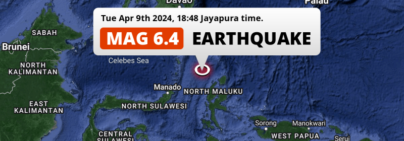
In the Maluku Sea 284 kilometer from Manado, Indonesia, a strong M6.4 earthquake occurred in the evening of Tuesday April 9th, 2024. The USGS has indicated there is a potential risk at tsunami's following this earthquake.
Felt the earthquake? Share this article: 


Earthquake Summary
This earthquake hit under water in the Maluku Sea, 108 kilometers (67 mi) off the coast of Indonesia, 284 kilometer east-northeast of Manado in North Sulawesi. The center of this earthquake had a quite shallow depth of 35 km. Shallow earthquakes usually have a larger impact than earthquakes deep in the earth.
| Date and Time: | Apr 9, 2024 18:48 (Jayapura Time) - Apr 9, 2024 09:48 Universal Time. |
|---|---|
| Location: | 284 km ENE of Manado, North Sulawesi, Indonesia. Coordinates 2°42'34"N 127°5'25"E. |
| Map: | 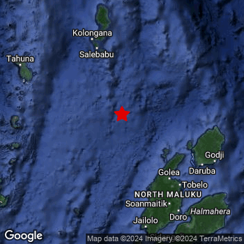 Map of area around epicenter. Click to open in Google Maps. |
| Magnitude: | MAG 6.4 Detected by 6 stations. Maximum Error Range ±0.041 . |
| Depth: | 35 km (22 mi) A quite shallow depth. |
| Max. Intensity: | V
Moderate On the Modified Mercalli Scale. |
| Tsunami Risk: | Potential tsunami risk The USGS has indicated there is a potential risk at tsunami's following this earthquake. Always stay cautious - More info here. |
Potential tsunami risk
There is a potential tsunami risk in the aftermath of this earthquake, immediately evacuate to higher grounds away from coastal areas and monitor advice from local authorities. The US Geographic Survey organization has indicated a potential risk for tsunami's following this earthquake.
Tsunami Risk Factors
| Factor | Under Sea? | MAG-6.5 or stronger? | Shallow depth? |
|---|---|---|---|
| Explanation | Almost all tsunami's are caused by earthquakes with their epicenter under sea or very near the sea. However stay cautious in coastal areas as earthquakes on land may cause landslides into sea, potentially still causing a local tsunami. | Under MAG 6.5: Very unlikely to cause a tsunami. MAG 6.5 to 7.5: Destructive tsunami's do occur, but are uncommon. Likely to observe small sea level changes. MAG 7.6+: Earthquakes with these magnitudes might produce destructive tsunami's. |
Most destructive tsunami's are caused by shallow earthquakes with a depth between 0 and 100km under the surface of the earth. Deeper tsunami's are unlikely to displace to ocean floor. |
| This Earthquake | This earthquake appears to have struck under the sea. | Not this earthquake. This earthquake had a magnitude of 6.4. Earthquakes of this strength are unlikely to trigger a tsunami. |
This earthquake occurred at a depth of of 35 km (22 mi). Earthquakes this shallow could trigger a tsunami. |
Minimal impact predicted
Based on scientific estimates by the US Geographic Survey (USGS), the risk of high fatalities for this earthquake is classified at level GREEN (low). They expect an 65% likelyhood of between 0 and 1 fatalities, and a 96% chance that the number of fatalities falls no higher than 10.
The USGS classifies the economic impact of this earthquake at level GREEN (low). They expect an 65% likelyhood of between 0 and 1 million US Dollars in economic damage and impact, and a 96% chance that the economic impact of this earthquake falls no higher than 10 million USD.
Roughly 1 million people exposed to shaking
This earthquake may have been felt by around 1 million people. That is the expected population size of the area exposed to a level of shaking of II or higher on the Modified Mercalli scale according to the USGS.
Light shaking and likely no damage may have been experienced by an estimated 940,600 people. At IV, it is the highest MMI level this earthquake has caused. All exposure to shaking was within the borders of Indonesia .
| People | MMI Level | Shaking | Damage |
|---|---|---|---|
| 0 | I |
Not noticable | None |
| 0 | II |
Very weak | None |
| 95,090 | III |
Weak | Probably none |
| 940,600 | IV |
Light | Likely none |
| 0 | V |
Moderate | Very light |
| 0 | VI |
Strong | Light |
| 0 | VII |
Very Strong | Moderate |
| 0 | VIII |
Severe | Moderate to heavy |
| 0 | IX |
Violent | Heavy |
| 0 | X |
Extreme | Very heavy |
Nearby towns and cities
This earthquake may have been felt in Indonesia . Ternate in North Maluku, Indonesia is the nearest significant place from the epicenter. The earthquake occurred 216 kilometer (134 mi) north of Ternate.
A complete list of nearby places is included below.
Overview of nearby places
| Distance | Place |
|---|---|
| 216 km (134 mi) S from epicenter |
Ternate North Maluku, Indonesia. |
| 225 km (140 mi) SSE from epicenter |
Sofifi North Maluku, Indonesia. |
| 284 km (176 mi) WSW from epicenter |
Manado North Sulawesi, Indonesia. |
| 288 km (179 mi) WSW from epicenter |
Tondano North Sulawesi, Indonesia. |
| 298 km (185 mi) WSW from epicenter |
Tomohon North Sulawesi, Indonesia. |
Earthquake Intensity Map
The maximum intensity (MMI Scale) caused by this earthquake is IV. The map below shows in which areas this earthquake was the most and least impactful. It is based on data from the US Geographic Survey.

Shaking reported by 3 people
People that feel an earthquake may report their experience to the US Geographic Survey. Currently, 3 people have reported shaking in 3 places, all within Philippines.We keep updating this article as more ground reports become available. You may report that you felt this earthquake here.
Places with most reports:
- Buayan, Southern Mindanao, Philippines: 1 person.
- Davao, Southern Mindanao, Philippines: 1 person.
- Katangawan, Southern Mindanao, Philippines: 1 person.
15 Aftershocks detected
Since this main shock, 15 smaller aftershocks were detected. At a distance of 30 km (19 mi) east of this earthquake, an aftershock struck 2 days later. It measured a magnitude of 4.6
Before this earthquake struck, 1 smaller foreshock occurred. Nearby this earthquake a foreshock struck 1 day earlier. It measured a magnitude of 4.3
Overview of foreshocks and aftershocks
| Classification | Magnitude | When | Where |
|---|---|---|---|
| Foreshock | M 4.3 |
1 day earlier Apr 8, 2024 08:07 (Jayapura Time) | 57 km (36 mi) N from Main Shock. |
| Main Shock This Earthquake |
M 6.4 |
Apr 9, 2024 18:48 (Jayapura Time) | - |
| Aftershock | M 3.7 |
22 mins later Apr 9, 2024 19:10 (Jayapura Time) | 28 km (17 mi) ENE from Main Shock. |
| Aftershock | M 3.7 |
49 mins later Apr 9, 2024 19:37 (Jayapura Time) | 15 km (9 mi) NE from Main Shock. |
| Aftershock | M 3.5 |
3 hrs later Apr 9, 2024 21:21 (Jayapura Time) | 10 km (6 mi) NE from Main Shock. |
| Aftershock | M 3.3 |
3 hrs later Apr 9, 2024 21:28 (Jayapura Time) | 17 km (10 mi) ENE from Main Shock. |
| Aftershock | M 3.6 |
5 hrs later Apr 9, 2024 23:36 (Jayapura Time) | 80 km (49 mi) WSW from Main Shock. |
| Aftershock | M 3.6 |
7 hrs later Apr 10, 2024 02:02 (Jayapura Time) | 20 km (13 mi) ENE from Main Shock. |
| Aftershock | M 4.2 |
7 hrs later Apr 10, 2024 02:15 (Jayapura Time) | 10 km (6 mi) ESE from Main Shock. |
| Aftershock | M 4.5 |
8 hrs later Apr 10, 2024 02:58 (Jayapura Time) | 7 km (5 mi) ESE from Main Shock. |
| Aftershock | M 3.2 |
10 hrs later Apr 10, 2024 04:37 (Jayapura Time) | 20 km (12 mi) E from Main Shock. |
| Aftershock | M 3.6 |
21 hrs later Apr 10, 2024 15:30 (Jayapura Time) | 16 km (10 mi) NE from Main Shock. |
| Aftershock | M 3.5 |
21 hrs later Apr 10, 2024 15:38 (Jayapura Time) | 83 km (51 mi) WNW from Main Shock. |
| Aftershock | M 3.3 |
1 day later Apr 10, 2024 19:53 (Jayapura Time) | 37 km (23 mi) SE from Main Shock. |
| Aftershock | M 4.4 |
2 days later Apr 11, 2024 11:07 (Jayapura Time) | 25 km (15 mi) ENE from Main Shock. |
| Aftershock | M 4.6 |
2 days later Apr 11, 2024 22:06 (Jayapura Time) | 30 km (19 mi) E from Main Shock. |
| Aftershock | M 3.2 |
3 days later Apr 12, 2024 13:37 (Jayapura Time) | 20 km (13 mi) E from Main Shock. |
More earthquakes coming?
Aftershocks are usually at least 1 order of magnitude less strong than main shocks. The more time passes, the smaller the chance and likely strength of any potential aftershocks.
The chance that a significant earthquake like this one is followed by an even larger earthquake is not so large. On average, scientists estimate a 94% chance that a major earthquake will not be followed by an even larger one. It is still adviced to be aware of this risk
Read: How to Stay Safe during an Earthquake (cdc.gov).Earthquakes like this are common in the region
Earthquakes of this strength occur quite regularly in the region. This is the strongest earthquake to hit since January 8th, 2024, when a 6.7 magnitude earthquake hit 267 km (166 mi) further north-northwest. An even stronger magnitude 7.1 earthquake struck on November 14th, 2019.
In total, 11 earthquakes with a magnitude of 6.4 or higher have been registered within 300km (186 mi) of this epicenter in the past 10 years. This comes down to an average of once every year.
Sources
Last updated 04/05/24 02:18 (). As more information on this earthquake becomes available this article will be updated. This article is automatically composed based on data originating from multiple sources.
- US Geographic Society (USGS): Earthquake us7000maxr
- European-Mediterranean Seismological Centre (EMSC): Earthquake 20240409_0000098
- Geonames.org: World Cities Database
- Google Maps: Static API
- Earthquakelist.org: Historic Earthquakes Database
Share this article:
