Latest earthquakes near Port Moresby, National Capital today
Complete overview of the latest earthquakes near Port Moresby, National Capital, Papua New Guinea, updated every minute. Did you feel an earthquake today in Port Moresby? If an earthquake is happening right now near Port Moresby, it will show up within minutes.
Recent Port Moresby Earthquake News
These are the latest articles published related to earthquakes occurring near Port Moresby. Check our Earthquake News section for a complete overview of articles written on earthquakes near Port Moresby and elsewhere.
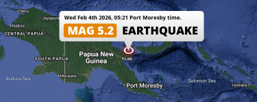 Feb 4, 2026 05:21AM
Significant M5.2 Earthquake hit near Lae in Papua New Guinea on Wednesday Night.
Feb 4, 2026 05:21AM
Significant M5.2 Earthquake hit near Lae in Papua New Guinea on Wednesday Night.
 Dec 22, 2025 08:31PM
Strong M6.5 Earthquake hit near Goroka in Papua New Guinea on Monday Evening.
Dec 22, 2025 08:31PM
Strong M6.5 Earthquake hit near Goroka in Papua New Guinea on Monday Evening.
Port Moresby Earthquake Statistics
Average
A total of 138 earthquakes with a magnitude of four or above have struck within 300 km (186 mi) of Port Moresby, National Capital in the past 10 years. This comes down to a yearly average of 13 earthquakes per year, or 1 per month. On average an earthquake will hit near Port Moresby roughly every 26 days.
A relatively large number of earthquakes occurred near Port Moresby in 2024. A total of 21 earthquakes (mag 4+) were detected within 300 km of Port Moresby that year. The strongest had a 5.2 magnitude.

Magnitude Distribution
The table below visualizes the distribution of all earthquakes that occurred within 300km of Port Moresby in the past 10 years. No earthquakes with a magnitude of 8 or above have occurred near Port Moresby during this time. Usually, higher magnitudes are less common than lower magnitudes. Small earthquakes with a magnitude below 4 on the Richter scale have been omitted from this overview.
| Magnitude | Earthquakes | Percentage |
|---|---|---|
| Mag. 4 | 120 | 86.96% |
| Mag. 5 | 16 | 11.59% |
| Mag. 6 | 0 | 0.0% |
| Mag. 7 | 2 | 1.45% |
| Mag. 8 | 0 | 0.0% |
| Mag. 9 | 0 | 0.0% |
| Mag. 10 | 0 | 0.0% |
Strongest earthquakes near Port Moresby
The strongest recent earthquake of the past 10 years near Port Moresby occurred on May 7, 2019 07:19 local time (Pacific/Port_Moresby timezone). It had a magnitude of 7.1 and struck 289 kilometers (180 mi) north-northwest of Port Moresby, at a depth of 146 km. Discover more strong earthquakes near Port Moresby in the list below.
A longer time ago, a MAG-7.5 earthquake struck on Feb 27, 1963 06:14, 236 kilometers (147 mi) north-northwest of Port Moresby. It is the strongest earthquake near Port Moresby in the past 126 years (Our data goes back to January 1st, 1900).
In the table below you will find the strongest earthquakes that occurred near Port Moresby, National Capital in the past 10 years. You can use the tabs to find the heaviest historic earthquakes since the year 1900 or within a specific year or distance from Port Moresby.
Nearest earthquakes from Port Moresby
These are the earthquakes with their epicenter nearest to Port Moresby, National Capital. You can use the buttons to find nearby earthquakes for a specific year or with a specific magnitude.
Frequently Asked Questions
These questions are commonly asked in relation to earthquakes occurring near Port Moresby.
When was the last earthquake in Port Moresby, National Capital?
A 5.2 magnitude earthquake hit near Port Moresby on the night of February 4, 2026 at 05:21 local time (Pacific/Port_Moresby). The center of this earthquake was located 364km north of Port Moresby at a depth of 70km under land. Check the list on our website for any earthquakes occurring near Port Moresby, National Capital in the past hours.
What was the strongest earthquake near Port Moresby, National Capital?
A 7.5 magnitude earthquake hit near Port Moresby on the morning of February 27, 1963 at 06:14 local time (Pacific/Port_Moresby). The center of this earthquake was located 236km north-northwest of Port Moresby at a depth of 187km under land. This is the strongest earthquake that occurred near Port Moresby since the year 1900.
How often do earthquakes occur near Port Moresby, National Capital?
In the past 10 years, 138 earthquakes with a magnitude of four or higher occurred within a 300 kilometer range from Port Moresby. This averages to 14 earthquakes yearly, or one earthquake every 26 days.
