
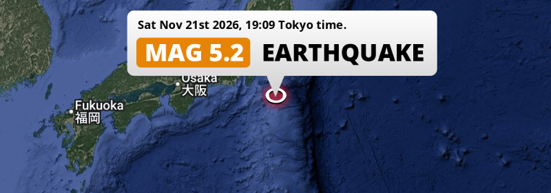
In the evening of Saturday November 21st, 2026, a shallow and significant Magnitude 5.2 earthquake hit in the North Pacific Ocean 166 kilometer from Yokohama, Japan.
Felt the earthquake? Share this article: 


Earthquake Summary
This earthquake hit under water in the North Pacific Ocean, 104 kilometers (64 mi) off the coast of Japan, 166 kilometer south of Yokohama in Kanagawa. The center of this earthquake had a very shallow depth of 10 km. Shallow earthquakes usually have a larger impact than earthquakes deep in the earth.
| Date and Time: | Nov 21, 2026 19:09 (Tokyo Time) - Nov 21, 2026 10:09 Universal Time. |
|---|---|
| Location: | 166 km south of Yokohama, Kanagawa, Japan. Coordinates 34°0'39"N 140°12'39"E. |
| Map: | 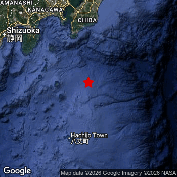 Map of area around epicenter. Click to open in Google Maps. |
| Magnitude: | MAG 5.2 Detected by 27 stations. Maximum Error Range ±0.11 . |
| Depth: | 10 km (6 mi) A very shallow depth. |
| Tsunami Risk: | Low tsunami risk Earthquakes under MAG-6.5 do not usually cause tsunami's. Always stay cautious - More info here. |
Nearby towns and cities
This earthquake may have been felt in Japan . Located 113 kilometer (70 mi) south of the epicenter of this earthquake, Tateyama (Chiba, Japan) is the nearest significant population center.
Major cities near this earthquake: Tokyo is located 193 km to the north. Yokohama is located 166 km to the north. Kawasaki is located 174 km to the north.
A complete list of nearby places is included below.
Overview of nearby places
| Distance | Place |
|---|---|
| 113 km (70 mi) N from epicenter |
Tateyama Chiba, Japan. |
| 137 km (85 mi) NW from epicenter |
Miura Kanagawa, Japan. |
| 148 km (92 mi) NW from epicenter |
Itō Shizuoka, Japan. |
| 150 km (93 mi) N from epicenter |
Yokosuka Kanagawa, Japan. |
| 152 km (94 mi) N from epicenter |
Kimitsu Chiba, Japan. |
| 154 km (96 mi) NW from epicenter |
Zushi Kanagawa, Japan. |
| 155 km (96 mi) N from epicenter |
Kisarazu Chiba, Japan. |
| 156 km (97 mi) NW from epicenter |
Kamakura Kanagawa, Japan. |
| 158 km (98 mi) N from epicenter |
Mobara Chiba, Japan. |
| 163 km (101 mi) NW from epicenter |
Fujisawa Kanagawa, Japan. |
| 165 km (103 mi) NW from epicenter |
Chigasaki Kanagawa, Japan. |
| 166 km (103 mi) N from epicenter |
Yokohama Kanagawa, Japan. |
| 167 km (104 mi) NW from epicenter |
Hiratsuka Kanagawa, Japan. |
| 168 km (104 mi) N from epicenter |
Ichihara Chiba, Japan. |
| 169 km (105 mi) NW from epicenter |
Odawara Kanagawa, Japan. |
| 171 km (106 mi) NW from epicenter |
Mishima Shizuoka, Japan. |
| 173 km (107 mi) NW from epicenter |
Numazu Shizuoka, Japan. |
| 174 km (108 mi) N from epicenter |
Kawasaki Kanagawa, Japan. |
| 175 km (109 mi) NW from epicenter |
Isehara Kanagawa, Japan. |
| 176 km (109 mi) NW from epicenter |
Hadano Kanagawa, Japan. |
| 177 km (110 mi) NW from epicenter |
Atsugi Kanagawa, Japan. |
| 177 km (110 mi) N from epicenter |
Chiba Chiba, Japan. |
| 179 km (111 mi) NW from epicenter |
Minamirinkan Kanagawa, Japan. |
| 181 km (112 mi) NW from epicenter |
Zama Kanagawa, Japan. |
| 182 km (113 mi) N from epicenter |
Yotsukaidō Chiba, Japan. |
| 184 km (114 mi) NW from epicenter |
Machida Tokyo, Japan. |
| 187 km (116 mi) N from epicenter |
Urayasu Tokyo, Japan. |
| 189 km (117 mi) N from epicenter |
Honchō Chiba, Japan. |
| 190 km (118 mi) NW from epicenter |
Fuji Shizuoka, Japan. |
| 190 km (118 mi) N from epicenter |
Sakura Chiba, Japan. |
| 193 km (120 mi) N from epicenter |
Chōfu Tokyo, Japan. |
| 193 km (120 mi) N from epicenter |
Tokyo Tokyo, Japan. |
| 194 km (121 mi) N from epicenter |
Tama Tokyo, Japan. |
| 197 km (122 mi) N from epicenter |
Narita Chiba, Japan. |
| 197 km (122 mi) N from epicenter |
Kamirenjaku Tokyo, Japan. |
| 198 km (123 mi) NW from epicenter |
Yaizu Shizuoka, Japan. |
| 198 km (123 mi) N from epicenter |
Musashino Tokyo, Japan. |
| 198 km (123 mi) NW from epicenter |
Fujinomiya Shizuoka, Japan. |
| 199 km (124 mi) N from epicenter |
Hino Tokyo, Japan. |
| 199 km (124 mi) NW from epicenter |
Shizuoka Shizuoka, Japan. |
| 199 km (124 mi) N from epicenter |
Matsudo Chiba, Japan. |
| 200 km (124 mi) NW from epicenter |
Hachiōji Tokyo, Japan. |
| 200 km (124 mi) N from epicenter |
Nishi-Tokyo-shi Tokyo, Japan. |
| 200 km (124 mi) N from epicenter |
Kokubunji Tokyo, Japan. |
| 205 km (127 mi) N from epicenter |
Kawaguchi Saitama, Japan. |
| 207 km (129 mi) N from epicenter |
Kashiwa Chiba, Japan. |
| 210 km (130 mi) N from epicenter |
Tokorozawa Saitama, Japan. |
| 212 km (132 mi) N from epicenter |
Koshigaya Saitama, Japan. |
| 217 km (135 mi) N from epicenter |
Saitama Saitama, Japan. |
| 221 km (137 mi) N from epicenter |
Kawagoe Saitama, Japan. |
| 238 km (148 mi) NW from epicenter |
Kōfu Yamanashi, Japan. |
| 240 km (149 mi) W from epicenter |
Hamamatsu Shizuoka, Japan. |
| 261 km (162 mi) N from epicenter |
Mito Ibaraki, Japan. |
| 273 km (170 mi) W from epicenter |
Toyohashi Aichi, Japan. |
| 275 km (171 mi) NW from epicenter |
Iida Nagano, Japan. |
| 285 km (177 mi) N from epicenter |
Maebashi Gunma, Japan. |
| 286 km (178 mi) N from epicenter |
Utsunomiya Tochigi, Japan. |
| 297 km (185 mi) NW from epicenter |
Nakatsugawa Gifu, Japan. |
Aftershocks detected
Since this main shock, 1 smaller aftershock was detected. At a distance of 45 km (28 mi) north of this earthquake, an aftershock struck 7 hrs later. It measured a magnitude of 4.6
Overview of foreshocks and aftershocks
| Classification | Magnitude | When | Where |
|---|---|---|---|
| Main Shock This Earthquake |
M 5.2 |
Nov 21, 2026 19:09 (Tokyo Time) | - |
| Aftershock | M 4.6 |
7 hrs later Nov 22, 2026 02:30 (Tokyo Time) | 45 km (28 mi) N from Main Shock. |
More earthquakes coming?
Aftershocks are usually at least 1 order of magnitude less strong than main shocks. The more time passes, the smaller the chance and likely strength of any potential aftershocks.
The chance that a significant earthquake like this one is followed by an even larger earthquake is not so large. On average, scientists estimate a 94% chance that a major earthquake will not be followed by an even larger one. It is still adviced to be aware of this risk
Read: How to Stay Safe during an Earthquake (cdc.gov).Earthquakes like this happen often in the region
Earthquakes of this strength are very common in the region. This is the strongest earthquake to hit since November 9th, 2026, when a 5.7 magnitude earthquake hit 289 km (180 mi) further north-east. An even stronger magnitude 6.3 earthquake struck on July 27th, 2019.
In total, 63 earthquakes with a magnitude of 5.2 or higher have been registered within 300km (186 mi) of this epicenter in the past 10 years. This comes down to an average of once every 2 months.
Low tsunami risk
Based on early data it appears this earthquake was not strong enough (lower than MAG-6.5) to be likely to cause destructive tsunami's. However this earthquake appeared to have hit at a shallow depth under sea, so stay cautious and monitor advice from local authorities.
Tsunami Risk Factors
| Factor | Under Sea? | MAG-6.5 or stronger? | Shallow depth? |
|---|---|---|---|
| Explanation | Almost all tsunami's are caused by earthquakes with their epicenter under sea or very near the sea. However stay cautious in coastal areas as earthquakes on land may cause landslides into sea, potentially still causing a local tsunami. | Under MAG 6.5: Very unlikely to cause a tsunami. MAG 6.5 to 7.5: Destructive tsunami's do occur, but are uncommon. Likely to observe small sea level changes. MAG 7.6+: Earthquakes with these magnitudes might produce destructive tsunami's. |
Most destructive tsunami's are caused by shallow earthquakes with a depth between 0 and 100km under the surface of the earth. Deeper tsunami's are unlikely to displace to ocean floor. |
| This Earthquake | This earthquake appears to have struck under the sea. | Not this earthquake. This earthquake had a magnitude of 5.2. Earthquakes of this strength are unlikely to trigger a tsunami. |
This earthquake occurred at a depth of of 10 km (6 mi). Earthquakes this shallow could trigger a tsunami. |
Sources
Last updated 21/11/26 19:48 (). This article contains currently available information about the earthquake and is automatically composed. We continue to update this article up to a few days after the earthquake occurred.
- US Geographic Society (USGS): Earthquake us6000ucky
- European-Mediterranean Seismological Centre (EMSC): Earthquake 20261121_0000150
- Geonames.org: World Cities Database
- Google Maps: Static API
- Earthquakelist.org: Historic Earthquakes Database
Share this article:
