
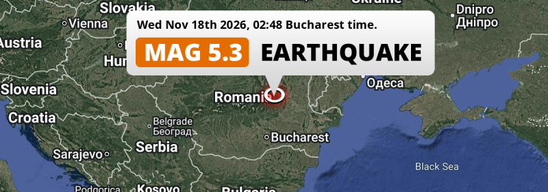
Under land 66 kilometer from Braşov in Romania, a significant M5.3 earthquake occurred in the night of Wednesday November 18th, 2026. Around 3.1 million people have been exposed to shaking. Moldova, Ukraine and Bulgaria are also near its epicenter.
Felt the earthquake? Share this article: 


Earthquake Summary
The earthquake struck on land in Romania, 66 kilometer (41 mi) east of Braşov in Brașov. The center of this earthquake had an intermediate depth of 132 km.
| Date and Time: | Nov 18, 2026 02:48 (Bucharest Time) - Nov 18, 2026 00:48 Universal Time. |
|---|---|
| Location: | 66 km east of Braşov, Brașov, Romania. Coordinates 45°40'54"N 26°27'8"E. |
| Map: | 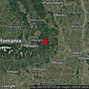 Map of area around epicenter. Click to open in Google Maps. |
| Magnitude: | MAG 5.3 Detected by 60 stations. Maximum Error Range ±0.04 . |
| Depth: | 132 km (82 mi) An intermediate depth. |
| Max. Intensity: | V
Moderate On the Modified Mercalli Scale. |
| Tsunami Risk: | Tsunami very unlikely Tsunami's are usually caused by MAG-6.5+ earthquakes, less than 100km shallow, and with an epicenter under sea. Neither of this seems to be the case. Always stay cautious - More info here. |
Minimal impact predicted
The US Geographic Survey (USGS) describes the impact of this earthquake as follows:
One person injured in Galati and 1 at Ramnicu Sarat. One home damaged at Braila.
Based on scientific estimates by the USGS, the risk of high fatalities for this earthquake is classified at level GREEN (low). They expect an 90% likelyhood of between 0 and 1 fatalities.
The USGS classifies the economic impact of this earthquake at level GREEN (low). They expect an 90% likelyhood of between 0 and 1 million US Dollars in economic damage and impact.
Roughly 3.1 million people exposed to shaking
An estimated 3.1 million have been exposed to shaking (An MMI or Modified Mercalli Intensity level II or higher) as a result of this earthquake according scientific estimates published by the USGS.
An estimated 2,043,000 people were exposed to level IV. At this level, light shaking and likely no damage can be expected. All exposure to shaking was within the borders of Romania .
| People | MMI Level | Shaking | Damage |
|---|---|---|---|
| 0 | I |
Not noticable | None |
| 0 | II |
Very weak | None |
| 1,105,000 | III |
Weak | Probably none |
| 2,043,000 | IV |
Light | Likely none |
| 0 | V |
Moderate | Very light |
| 0 | VI |
Strong | Light |
| 0 | VII |
Very Strong | Moderate |
| 0 | VIII |
Severe | Moderate to heavy |
| 0 | IX |
Violent | Heavy |
| 0 | X |
Extreme | Very heavy |
Nearby towns and cities
Romania , Moldova , Ukraine and Bulgaria are all located within 300km distance of the epicenter of the earthquake.
Located 43 kilometer (27 mi) south-east of the epicenter of this earthquake, Târgu Secuiesc (Covasna, Romania) is the nearest significant population center. The intensity of shaking and damage in Târgu Secuiesc is estimated to be around level IV on the Modified Mercalli Intensity scale (light shaking, likely no damage).
Multiple large cities are in proximity of today's earthquake. Bucharest is located 142 km to the south (intensity unknown, possibly low). Braşov is located 66 km to the west and experienced an intensity of III (weak shaking, probably no damage). Sector 3 is located 142 km to the south (intensity unknown, possibly low).
An overview of nearby towns and cities is available in the overview below. If places don't have intensity data available, it likely means the experienced impact in those places was fairly small.
Overview of nearby places
| Distance | Place | Intensity (MMI) |
|---|---|---|
| 43 km (27 mi) NW from epicenter |
Târgu Secuiesc Covasna, Romania. |
IV
Light |
| 56 km (35 mi) W from epicenter |
Sfântu Gheorghe Covasna, Romania. |
III
Weak |
| 57 km (35 mi) E from epicenter |
Focșani Vrancea, Romania. |
IV
Light |
| 57 km (35 mi) SE from epicenter |
Râmnicu Sărat Buzău, Romania. |
IV
Light |
| 58 km (36 mi) W from epicenter |
Săcele Brașov, Romania. |
III
Weak |
| 66 km (41 mi) W from epicenter |
Braşov Brașov, Romania. |
III
Weak |
| 66 km (41 mi) SE from epicenter |
Buzău Buzău, Romania. |
IV
Light |
| 72 km (45 mi) NE from epicenter |
Adjud Vrancea, Romania. |
IV
Light |
| 74 km (46 mi) S from epicenter |
Mizil Prahova, Romania. |
IV
Light |
| 78 km (48 mi) W from epicenter |
Codlea Brașov, Romania. |
III
Weak |
| 78 km (48 mi) E from epicenter |
Tecuci Galați, Romania. |
IV
Light |
| 79 km (49 mi) W from epicenter |
Râşnov Brașov, Romania. |
III
Weak |
| 82 km (51 mi) N from epicenter |
Comăneşti Bacău, Romania. |
IV
Light |
| 83 km (52 mi) SW from epicenter |
Breaza Prahova, Romania. |
IV
Light |
| 83 km (52 mi) SW from epicenter |
Câmpina Prahova, Romania. |
IV
Light |
| 86 km (53 mi) SW from epicenter |
Băicoi Prahova, Romania. |
IV
Light |
| 88 km (55 mi) N from epicenter |
Moineşti Bacău, Romania. |
IV
Light |
| 88 km (55 mi) S from epicenter |
Ploieşti Prahova, Romania. |
IV
Light |
| 89 km (55 mi) W from epicenter |
Zărnești Brașov, Romania. |
III
Weak |
| 90 km (56 mi) NW from epicenter |
Miercurea-Ciuc Harghita, Romania. |
IV
Light |
| 100 km (62 mi) SW from epicenter |
Moreni Dâmbovița, Romania. |
IV
Light |
| 105 km (65 mi) N from epicenter |
Bacău Bacău, Romania. |
IV
Light |
| 112 km (70 mi) NW from epicenter |
Odorheiu Secuiesc Harghita, Romania. |
III
Weak |
| 112 km (70 mi) NE from epicenter |
Bârlad Vaslui, Romania. |
IV
Light |
| 115 km (71 mi) SW from epicenter |
Târgovişte Dâmbovița, Romania. |
IV
Light |
| 117 km (73 mi) W from epicenter |
Făgăraș Brașov, Romania. |
|
| 127 km (79 mi) E from epicenter |
Brăila Brăila, Romania. |
|
| 127 km (79 mi) E from epicenter |
Galaţi Galați, Romania. |
|
| 134 km (83 mi) S from epicenter |
Voluntari Ilfov, Romania. |
|
| 136 km (85 mi) S from epicenter |
Sector 1 București, Romania. |
|
| 138 km (86 mi) E from epicenter |
Cahul Cahul, Moldova. |
|
| 138 km (86 mi) N from epicenter |
Piatra Neamţ Neamț, Romania. |
|
| 139 km (86 mi) S from epicenter |
Sector 2 București, Romania. |
|
| 142 km (88 mi) S from epicenter |
Bucharest București, Romania. |
|
| 142 km (88 mi) S from epicenter |
Sector 3 București, Romania. |
|
| 143 km (89 mi) N from epicenter |
Roman Neamț, Romania. |
|
| 143 km (89 mi) SE from epicenter |
Slobozia Ialomița, Romania. |
|
| 143 km (89 mi) S from epicenter |
Sector 6 București, Romania. |
|
| 145 km (90 mi) NE from epicenter |
Vaslui Vaslui, Romania. |
|
| 147 km (91 mi) S from epicenter |
Sector 5 București, Romania. |
|
| 148 km (92 mi) S from epicenter |
Sector 4 București, Romania. |
|
| 155 km (96 mi) SW from epicenter |
Piteşti Arges, Romania. |
|
| 175 km (109 mi) NW from epicenter |
Târgu-Mureş Mureș, Romania. |
|
| 175 km (109 mi) W from epicenter |
Râmnicu Vâlcea Vâlcea, Romania. |
|
| 178 km (111 mi) S from epicenter |
Olteniţa Silistra, Romania. |
|
| 179 km (111 mi) W from epicenter |
Sibiu Sibiu, Romania. |
|
| 183 km (114 mi) E from epicenter |
Comrat Găgăuzia, Moldova. |
|
| 185 km (115 mi) S from epicenter |
Silistra Silistra, Bulgaria. |
|
| 187 km (116 mi) NE from epicenter |
Iaşi Iași, Romania. |
|
| 189 km (117 mi) E from epicenter |
Izmail Odessa, Ukraine. |
|
| 192 km (119 mi) E from epicenter |
Tulcea Tulcea, Romania. |
|
| 199 km (124 mi) NE from epicenter |
Ungheni Ungheni, Moldova. |
|
| 203 km (126 mi) S from epicenter |
Giurgiu Giurgiu, Romania. |
|
| 208 km (129 mi) S from epicenter |
Ruse Ruse, Bulgaria. |
|
| 208 km (129 mi) NE from epicenter |
Hînceşti Hînceşti, Moldova. |
|
| 208 km (129 mi) SW from epicenter |
Alexandria Teleorman, Romania. |
|
| 215 km (134 mi) SW from epicenter |
Slatina Olt, Romania. |
|
| 218 km (135 mi) N from epicenter |
Suceava Suceava, Romania. |
|
| 220 km (137 mi) NW from epicenter |
Bistriţa Bistrița-Năsăud, Romania. |
|
| 226 km (140 mi) W from epicenter |
Alba Iulia Alba, Romania. |
|
| 231 km (144 mi) N from epicenter |
Botoşani Botoșani, Romania. |
|
| 232 km (144 mi) NE from epicenter |
Strășeni Strășeni, Moldova. |
|
| 236 km (147 mi) NE from epicenter |
Chisinau Chișinău Municipality, Moldova. |
|
| 239 km (149 mi) SE from epicenter |
Constanţa Constanța, Romania. |
|
| 239 km (149 mi) S from epicenter |
Razgrad Razgrad, Bulgaria. |
|
| 250 km (155 mi) NW from epicenter |
Cluj-Napoca Cluj, Romania. |
|
| 251 km (156 mi) NE from epicenter |
Căuşeni Căuşeni, Moldova. |
|
| 251 km (156 mi) NE from epicenter |
Bilicenii Vechi Sîngerei, Moldova. |
|
| 257 km (160 mi) NE from epicenter |
Bălţi Bălţi, Moldova. |
|
| 257 km (160 mi) W from epicenter |
Târgu Jiu Gorj, Romania. |
|
| 258 km (160 mi) SW from epicenter |
Craiova Dolj, Romania. |
|
| 258 km (160 mi) NW from epicenter |
Borşa Maramureş, Romania. |
|
| 259 km (161 mi) SE from epicenter |
Dobrich Dobrich, Bulgaria. |
|
| 262 km (163 mi) NE from epicenter |
Orhei Orhei, Moldova. |
|
| 265 km (165 mi) NE from epicenter |
Bender Bender Municipality, Moldova. |
|
| 270 km (168 mi) S from epicenter |
Targovishte Targovishte, Bulgaria. |
|
| 271 km (168 mi) S from epicenter |
Shumen Shumen, Bulgaria. |
|
| 276 km (171 mi) W from epicenter |
Hunedoara Hunedoara, Romania. |
|
| 276 km (171 mi) NE from epicenter |
Tiraspol Stînga Nistrului, Moldova. |
|
| 281 km (175 mi) N from epicenter |
Drochia Drochia, Moldova. |
|
| 283 km (176 mi) NE from epicenter |
Floreşti Floreşti, Moldova. |
|
| 284 km (176 mi) N from epicenter |
Edineţ Raionul Edineţ, Moldova. |
|
| 291 km (181 mi) SW from epicenter |
Pleven Pleven, Bulgaria. |
|
| 293 km (182 mi) N from epicenter |
Chernivtsi Chernivtsi Oblast, Ukraine. |
|
| 296 km (184 mi) S from epicenter |
Veliko Tŭrnovo Veliko Tarnovo, Bulgaria. |
|
| 298 km (185 mi) SE from epicenter |
Varna Varna, Bulgaria. |
Earthquake Intensity Map
The maximum intensity (MMI Scale) caused by this earthquake is IV. The map below shows in which areas this earthquake was the most and least impactful. It is based on data from the US Geographic Survey.

Shaking reported by 239 people in 6 countries
People that feel an earthquake may report their experience to the US Geographic Survey. Currently, 239 people have reported shaking in 77 places in 6 countries (Romania, Moldova, Bulgaria, Ukraine, Serbia and Montenegro, Turkey).We keep updating this article as more ground reports become available. You may report that you felt this earthquake here.
Places with most reports:
- Bucharest, Bukarest, Romania: 65 people.
- Braşov, Braşov, Romania: 22 people.
- Voluntari, Ilfov, Romania: 13 people.
- Iaşi, Iaşi, Romania: 13 people.
- Chişinău, Chişinău, Moldova: 10 people.
- Chiajna, Ilfov, Romania: 7 people.
- Constanţa, Constanţa, Romania: 4 people.
- Popeşti-Leordeni, Ilfov, Romania: 4 people.
- Ruse, Ruse, Bulgaria: 4 people.
- Varna, Varna, Bulgaria: 4 people.
Aftershocks detected
This main shock was followed by 1 smaller aftershock. A 3.1 magnitude earthquake hit 17 hrs later 31 km (19 mi) southwest of this earthquake.
Overview of foreshocks and aftershocks
| Classification | Magnitude | When | Where |
|---|---|---|---|
| Main Shock This Earthquake |
M 5.3 |
Nov 18, 2026 02:48 (Bucharest Time) | - |
| Aftershock | M 3.1 |
17 hrs later Nov 18, 2026 20:05 (Bucharest Time) | 31 km (19 mi) SW from Main Shock. |
More earthquakes coming?
Aftershocks are usually at least 1 order of magnitude less strong than main shocks. The more time passes, the smaller the chance and likely strength of any potential aftershocks.
The chance that a significant earthquake like this one is followed by an even larger earthquake is not so large. On average, scientists estimate a 94% chance that a major earthquake will not be followed by an even larger one. It is still adviced to be aware of this risk
Read: How to Stay Safe during an Earthquake (cdc.gov).This is the strongest earthquake in 4 years
Earthquakes of this strength occur quite regularly in the region. This is the strongest earthquake to hit since February 14th, 2023, when a 5.6 magnitude earthquake hit 262 km (163 mi) further west. That was also the heaviest earthquake to hit the region in the past 10 years.
In total, 3 earthquakes with a magnitude of 5.3 or higher have been registered within 300km (186 mi) of this epicenter in the past 10 years. This comes down to an average of once every 3 years.
Tsunami very unlikely
It is very unlikely that this eartquake will cause any tsunami's. The reported magnitude is lower than the MAG-6.5 strength required to cause any earthquakes. In addition, this earthquake was not very shallow and appears to have occurred under land. However always stay cautious and monitor advice from local authorities.
Tsunami Risk Factors
| Factor | Under Sea? | MAG-6.5 or stronger? | Shallow depth? |
|---|---|---|---|
| Explanation | Almost all tsunami's are caused by earthquakes with their epicenter under sea or very near the sea. However stay cautious in coastal areas as earthquakes on land may cause landslides into sea, potentially still causing a local tsunami. | Under MAG 6.5: Very unlikely to cause a tsunami. MAG 6.5 to 7.5: Destructive tsunami's do occur, but are uncommon. Likely to observe small sea level changes. MAG 7.6+: Earthquakes with these magnitudes might produce destructive tsunami's. |
Most destructive tsunami's are caused by shallow earthquakes with a depth between 0 and 100km under the surface of the earth. Deeper tsunami's are unlikely to displace to ocean floor. |
| This Earthquake | Not this earthquake. This earthquake appears to have struck on land far from any coast. |
Not this earthquake. This earthquake had a magnitude of 5.3. Earthquakes of this strength are unlikely to trigger a tsunami. |
Not this earthquake. This earthquake occurred at a depth of 132 km (82 mi). Earthquakes this deep in the earth are unlikely to trigger a tsunami. |
Sources
Last updated 21/11/26 23:58 (). This article is automatically generated based on available data. We keep checking multiple sources for additional information. This article gets updated as new details on this earthquake become available.
- US Geographic Society (USGS): Earthquake us7000tyw8
- European-Mediterranean Seismological Centre (EMSC): Earthquake 20261118_0000012
- Geonames.org: World Cities Database
- Google Maps: Static API
- Earthquakelist.org: Historic Earthquakes Database
Share this article:
