
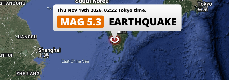
A shallow and significant Magnitude 5.3 earthquake struck under land 9 kilometer from Minamata in Japan in the night of Thursday November 19th, 2026. The earthquake struck near a very densely populated region.
Felt the earthquake? Share this article: 


Earthquake Summary
The earthquake struck on land in Japan, 9 kilometer (6 mi) north-east of Minamata in Kumamoto. The center of this earthquake had a very shallow depth of 10 km. Shallow earthquakes usually have a larger impact than earthquakes deep in the earth.
| Date and Time: | Nov 19, 2026 02:22 (Tokyo Time) - Nov 18, 2026 17:22 Universal Time. |
|---|---|
| Location: | 9 km NE of Minamata, Kumamoto, Japan. Coordinates 32°16'40"N 130°27'39"E. |
| Map: | 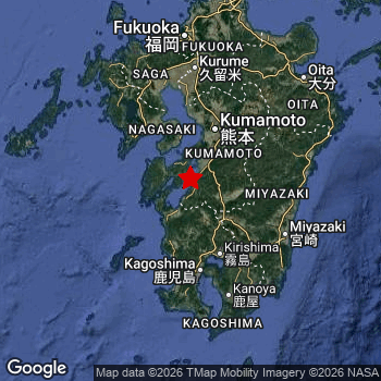 Map of area around epicenter. Click to open in Google Maps. |
| Magnitude: | MAG 5.3 Detected by 24 stations. Maximum Error Range ±0.063 . |
| Depth: | 10 km (6 mi) A very shallow depth. |
| Tsunami Risk: | Tsunami very unlikely While this was a shallow earthquake in a coastal area, it appears to have occurred under land (1 km from the sea) with a magnitude that is usually not strong enough to cause tsunami's. Always stay cautious - More info here. |
Nearby towns and cities
This earthquake may have been felt in Japan . The closest significant population center near the earthquake is Minamata in Kumamoto, Japan. Minamata is located 9 kilometer (6 mi) north-east of the epicenter.
Major cities near this earthquake: Kumamoto is located 63 km to the north. Fukuoka is located 147 km to the north. Kagoshima is located 80 km to the south.
A complete list of nearby places is included below.
Overview of nearby places
| Distance | Place |
|---|---|
| 9 km (6 mi) SW from epicenter |
Minamata Kumamoto, Japan. |
| 23 km (14 mi) S from epicenter |
Izumi Kagoshima, Japan. |
| 28 km (17 mi) E from epicenter |
Hitoyoshi Kumamoto, Japan. |
| 28 km (17 mi) SE from epicenter |
Ōkuchi-shinohara Kagoshima, Japan. |
| 28 km (17 mi) NE from epicenter |
Honmachi Kumamoto, Japan. |
| 34 km (21 mi) NW from epicenter |
Hondomachi-hondo Kumamoto, Japan. |
| 38 km (24 mi) SW from epicenter |
Akune Kagoshima, Japan. |
| 42 km (26 mi) W from epicenter |
Ushibukamachi Kumamoto, Japan. |
| 46 km (29 mi) NE from epicenter |
Matsubase Kumamoto, Japan. |
| 49 km (30 mi) NE from epicenter |
Uto Kumamoto, Japan. |
| 53 km (33 mi) S from epicenter |
Satsumasendai Kagoshima, Japan. |
| 57 km (35 mi) N from epicenter |
Shimabara Nagasaki, Japan. |
| 59 km (37 mi) NE from epicenter |
Mifune Kumamoto, Japan. |
| 59 km (37 mi) SE from epicenter |
Kobayashi Miyazaki, Japan. |
| 63 km (39 mi) N from epicenter |
Kumamoto Kumamoto, Japan. |
| 64 km (40 mi) S from epicenter |
Kajiki Kagoshima, Japan. |
| 65 km (40 mi) S from epicenter |
Kushikino Kagoshima, Japan. |
| 67 km (42 mi) SE from epicenter |
Hamanoichi Kagoshima, Japan. |
| 67 km (42 mi) SE from epicenter |
Kokubu-matsuki Kagoshima, Japan. |
| 72 km (45 mi) N from epicenter |
Uekimachi-mōno Kumamoto, Japan. |
| 73 km (45 mi) N from epicenter |
Nagasu Kumamoto, Japan. |
| 74 km (46 mi) NW from epicenter |
Isahaya Nagasaki, Japan. |
| 74 km (46 mi) S from epicenter |
Ijūin Kagoshima, Japan. |
| 75 km (47 mi) NW from epicenter |
Nagasaki Nagasaki, Japan. |
| 75 km (47 mi) N from epicenter |
Tamana Kumamoto, Japan. |
| 77 km (48 mi) NE from epicenter |
Ōzu Kumamoto, Japan. |
| 80 km (50 mi) S from epicenter |
Kagoshima Kagoshima, Japan. |
| 81 km (50 mi) NW from epicenter |
Obita Nagasaki, Japan. |
| 83 km (52 mi) SE from epicenter |
Miyakonojō Miyazaki, Japan. |
| 84 km (52 mi) N from epicenter |
Ōmuta Fukuoka, Japan. |
| 84 km (52 mi) NW from epicenter |
Togitsu Nagasaki, Japan. |
| 85 km (53 mi) NE from epicenter |
Kikuchi Kumamoto, Japan. |
| 85 km (53 mi) N from epicenter |
Yamaga Kumamoto, Japan. |
| 86 km (53 mi) NW from epicenter |
Ōmura Nagasaki, Japan. |
| 87 km (54 mi) SE from epicenter |
Sueyoshichō-ninokata Kagoshima, Japan. |
| 91 km (57 mi) S from epicenter |
Tarumizu Kagoshima, Japan. |
| 91 km (57 mi) E from epicenter |
Tsuma Miyazaki, Japan. |
| 93 km (58 mi) NE from epicenter |
Aso Kumamoto, Japan. |
| 97 km (60 mi) S from epicenter |
Kaseda-shirakame Kagoshima, Japan. |
| 97 km (60 mi) N from epicenter |
Setakamachi-takayanagi Fukuoka, Japan. |
| 98 km (61 mi) N from epicenter |
Kashima Saga, Japan. |
| 99 km (62 mi) N from epicenter |
Yanagawa Fukuoka, Japan. |
| 99 km (62 mi) SE from epicenter |
Miyazaki Miyazaki, Japan. |
| 99 km (62 mi) E from epicenter |
Takanabe Miyazaki, Japan. |
| 107 km (66 mi) N from epicenter |
Saga Saga, Japan. |
| 116 km (72 mi) N from epicenter |
Kurume Fukuoka, Japan. |
| 118 km (73 mi) E from epicenter |
Nobeoka Miyazaki, Japan. |
| 121 km (75 mi) NW from epicenter |
Sasebo Nagasaki, Japan. |
| 147 km (91 mi) N from epicenter |
Fukuoka Fukuoka, Japan. |
| 150 km (93 mi) NE from epicenter |
Ōita Ōita, Japan. |
| 179 km (111 mi) N from epicenter |
Kitakyushu Fukuoka, Japan. |
| 191 km (119 mi) N from epicenter |
Shimonoseki Yamaguchi, Japan. |
| 244 km (152 mi) E from epicenter |
Nakamura Kōchi, Japan. |
| 276 km (171 mi) NE from epicenter |
Matsuyama Ehime, Japan. |
| 295 km (183 mi) NE from epicenter |
Masuda Shimane, Japan. |
| 300 km (186 mi) NE from epicenter |
Hiroshima Hirochima, Japan. |
Shaking reported by 1 person
People that feel an earthquake may report their experience to the US Geographic Survey. Currently, 1 person has reported shaking in one place in Japan.We keep updating this article as more ground reports become available. You may report that you felt this earthquake here.
Places with most reports:
- Fukuoka, Fukuoka, Japan: 1 person.
2 Aftershocks detected
This main shock was followed by 2 smaller aftershocks. At a distance of 6 km (4 mi) northwest of this earthquake, an aftershock struck 14 mins later. It measured a magnitude of 3.7
This main shock was prefaced by 1 smaller foreshock. A 3.3 magnitude earthquake hit 23 hrs earlier nearby.
Overview of foreshocks and aftershocks
| Classification | Magnitude | When | Where |
|---|---|---|---|
| Foreshock | M 3.3 |
23 hrs earlier Nov 18, 2026 02:54 (Tokyo Time) | 14 km (9 mi) N from Main Shock. |
| Main Shock This Earthquake |
M 5.3 |
Nov 19, 2026 02:22 (Tokyo Time) | - |
| Aftershock | M 3.5 |
3 mins later Nov 19, 2026 02:25 (Tokyo Time) | 4 km (2.7 mi) NE from Main Shock. |
| Aftershock | M 3.7 |
14 mins later Nov 19, 2026 02:36 (Tokyo Time) | 6 km (4 mi) NW from Main Shock. |
More earthquakes coming?
The risk of aftershocks decreases rapidly over time. Usually, aftershocks are at least one order of magnitude lower than a main shock.
The chance that a significant earthquake like this one is followed by an even larger earthquake is not so large. On average, scientists estimate a 94% chance that a major earthquake will not be followed by an even larger one. It is still adviced to be aware of this risk
Read: How to Stay Safe during an Earthquake (cdc.gov).Earthquakes like this happen often in the region
Earthquakes of this strength are very common in the region. This is the strongest earthquake to hit since August 1st, 2026, when a 5.3 magnitude earthquake hit 144 km (89 mi) further east. An even stronger magnitude 7.1 earthquake struck on August 8th, 2024.
In total, 38 earthquakes with a magnitude of 5.3 or higher have been registered within 300km (186 mi) of this epicenter in the past 10 years. This comes down to an average of once every 3 months.
Tsunami very unlikely
While MAG-6.5+ earthquakes may cause tsunami's, it appears that the epicenter of this earthquake hit under land. In addition, the reported depth is deeper than 100km, making the risk of a tsunami even less likely. However always stay cautious and monitor advice from local authorities.
Tsunami Risk Factors
| Factor | Under Sea? | MAG-6.5 or stronger? | Shallow depth? |
|---|---|---|---|
| Explanation | Almost all tsunami's are caused by earthquakes with their epicenter under sea or very near the sea. However stay cautious in coastal areas as earthquakes on land may cause landslides into sea, potentially still causing a local tsunami. | Under MAG 6.5: Very unlikely to cause a tsunami. MAG 6.5 to 7.5: Destructive tsunami's do occur, but are uncommon. Likely to observe small sea level changes. MAG 7.6+: Earthquakes with these magnitudes might produce destructive tsunami's. |
Most destructive tsunami's are caused by shallow earthquakes with a depth between 0 and 100km under the surface of the earth. Deeper tsunami's are unlikely to displace to ocean floor. |
| This Earthquake | This earthquake appears to have struck on land near a coastal area (1 km from the sea). | Not this earthquake. This earthquake had a magnitude of 5.3. Earthquakes of this strength are unlikely to trigger a tsunami. |
This earthquake occurred at a depth of of 10 km (6 mi). Earthquakes this shallow could trigger a tsunami. |
Sources
Last updated 18/11/26 17:58 (). As more information on this earthquake becomes available this article will be updated. This article is automatically composed based on data originating from multiple sources.
- US Geographic Society (USGS): Earthquake us7000tz1n
- European-Mediterranean Seismological Centre (EMSC): Earthquake 20261118_0000267
- Geonames.org: World Cities Database
- Google Maps: Static API
- Earthquakelist.org: Historic Earthquakes Database
Share this article:
