
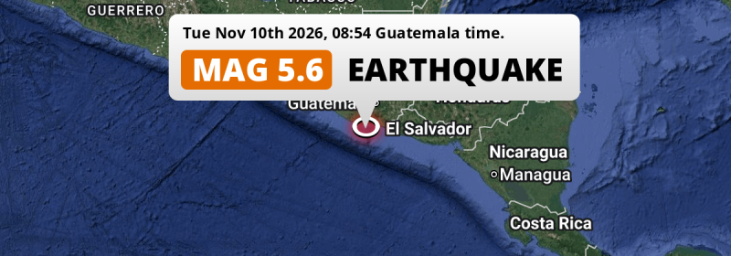
In the North Pacific Ocean 129 kilometer from Guatemala City, Guatemala, a significant M5.6 earthquake occurred in the morning of Tuesday November 10th, 2026. Around 2 million people have been exposed to shaking. El Salvador, Mexico and Honduras are also near its epicenter.
Felt the earthquake? Share this article: 


Earthquake Summary
This earthquake hit under water in the North Pacific Ocean, 43 kilometers (26 mi) off the coast of Guatemala, 129 kilometer south of Guatemala City. The center of this earthquake had a quite shallow depth of 35 km. Shallow earthquakes usually have a larger impact than earthquakes deep in the earth.
| Date and Time: | Nov 10, 2026 08:54AM (Guatemala Time) - Nov 10, 2026 14:54 Universal Time. |
|---|---|
| Location: | 129 km south of Guatemala City, Guatemala, Guatemala. Coordinates 13°32'17"N 90°52'47"W. |
| Map: | 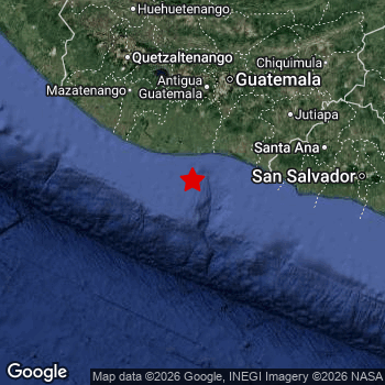 Map of area around epicenter. Click to open in Google Maps. |
| Magnitude: | MAG 5.6 Detected by 37 stations. Maximum Error Range ±0.051 . |
| Depth: | 35 km (22 mi) A quite shallow depth. |
| Max. Intensity: | V
Moderate On the Modified Mercalli Scale. |
| Tsunami Risk: | Low tsunami risk Earthquakes under MAG-6.5 do not usually cause tsunami's. Always stay cautious - More info here. |
Minimal impact predicted
Based on scientific estimates by the US Geographic Survey (USGS), the risk of high fatalities for this earthquake is classified at level GREEN (low). They expect an 90% likelyhood of between 0 and 1 fatalities.
The USGS classifies the economic impact of this earthquake at level GREEN (low). They expect an 90% likelyhood of between 0 and 1 million US Dollars in economic damage and impact.
Roughly 2 million people exposed to shaking
The USGS has published a report estimating the number of people exposed to this earthquake. Acoording to their analysis, roughly 2 million have been exposed to shaking at an MMI level of II or higher.
The highest earthquake impact level for this earthquake is IV, which corresponds with light shaking and likely no damage. Roughly 830,700 people are expected to be exposed to this level. Intensity level III was experienced by the majority of people (around 1.2 million). In their region, weak shaking and probably no damage can be expected.
People in 2 countries have been exposed to shaking. In Guatemala , around 2 million people, with impact levels up to IV (light shaking, likely no damage). People were exposed to shaking in El Salvador as well.
| People | MMI Level | Shaking | Damage |
|---|---|---|---|
| 0 | I |
Not noticable | None |
| 0 | II |
Very weak | None |
| 1,199,000 | III |
Weak | Probably none |
| 830,700 | IV |
Light | Likely none |
| 0 | V |
Moderate | Very light |
| 0 | VI |
Strong | Light |
| 0 | VII |
Very Strong | Moderate |
| 0 | VIII |
Severe | Moderate to heavy |
| 0 | IX |
Violent | Heavy |
| 0 | X |
Extreme | Very heavy |
Nearby towns and cities
Guatemala , El Salvador , Mexico and Honduras are all located within 300km distance of the epicenter of the earthquake.
The closest significant population center near the earthquake is Puerto San José in Escuintla, Guatemala. Puerto San José is located 44 kilometer (27 mi) south of the epicenter. The intensity of shaking and damage in Puerto San José is estimated to be around level IV on the Modified Mercalli Intensity scale (light shaking, likely no damage).
Major cities near this earthquake: Guatemala City is located 129 km to the north (intensity unknown, possibly low). Mixco is located 125 km to the north (intensity unknown, possibly low). Villa Nueva is located 114 km to the north (intensity unknown, possibly low).
An overview of nearby towns and cities is available in the overview below. If places don't have intensity data available, it likely means the experienced impact in those places was fairly small.
Overview of nearby places
| Distance | Place | Intensity (MMI) |
|---|---|---|
| 44 km (27 mi) N from epicenter |
Puerto San José Escuintla, Guatemala. |
IV
Light |
| 63 km (39 mi) N from epicenter |
La Gomera Escuintla, Guatemala. |
IV
Light |
| 85 km (53 mi) N from epicenter |
Escuintla Escuintla, Guatemala. |
IV
Light |
| 90 km (56 mi) N from epicenter |
Santa Lucía Cotzumalguapa Escuintla, Guatemala. |
III
Weak |
| 98 km (61 mi) N from epicenter |
Palín Escuintla, Guatemala. |
III
Weak |
| 98 km (61 mi) NW from epicenter |
Tiquisate Escuintla, Guatemala. |
IV
Light |
| 102 km (63 mi) NE from epicenter |
Barberena Santa Rosa, Guatemala. |
III
Weak |
| 103 km (64 mi) NE from epicenter |
Cuilapa Santa Rosa, Guatemala. |
III
Weak |
| 106 km (66 mi) N from epicenter |
Alotenango Sacatepéquez, Guatemala. |
|
| 108 km (67 mi) N from epicenter |
Amatitlán Guatemala, Guatemala. |
|
| 110 km (68 mi) N from epicenter |
Ciudad Vieja Sacatepéquez, Guatemala. |
|
| 111 km (69 mi) N from epicenter |
Villa Canales Guatemala, Guatemala. |
|
| 113 km (70 mi) NE from epicenter |
Fraijanes Guatemala, Guatemala. |
|
| 113 km (70 mi) N from epicenter |
Petapa Guatemala, Guatemala. |
|
| 114 km (71 mi) E from epicenter |
Acajutla Sonsonate, El Salvador. |
|
| 114 km (71 mi) N from epicenter |
Villa Nueva Guatemala, Guatemala. |
|
| 115 km (71 mi) N from epicenter |
Antigua Guatemala Sacatepéquez, Guatemala. |
|
| 120 km (75 mi) E from epicenter |
Ahuachapán Ahuachapán, El Salvador. |
|
| 122 km (76 mi) NW from epicenter |
Chicacao Suchitepeque, Guatemala. |
|
| 122 km (76 mi) N from epicenter |
Santa Catarina Pinula Guatemala, Guatemala. |
|
| 123 km (76 mi) NE from epicenter |
San José Pinula Guatemala, Guatemala. |
|
| 124 km (77 mi) N from epicenter |
Sumpango Sacatepéquez, Guatemala. |
|
| 124 km (77 mi) N from epicenter |
Santiago Sacatepéquez Sacatepéquez, Guatemala. |
|
| 125 km (78 mi) N from epicenter |
Chimaltenango Chimaltenango, Guatemala. |
|
| 125 km (78 mi) N from epicenter |
Mixco Guatemala, Guatemala. |
|
| 126 km (78 mi) E from epicenter |
Sonsonate Sonsonate, El Salvador. |
|
| 128 km (80 mi) N from epicenter |
Santiago Atitlán Sololá, Guatemala. |
|
| 129 km (80 mi) N from epicenter |
Guatemala City Guatemala, Guatemala. |
|
| 130 km (81 mi) NW from epicenter |
Mazatenango Suchitepeque, Guatemala. |
|
| 134 km (83 mi) N from epicenter |
San Juan Sacatepéquez Guatemala, Guatemala. |
|
| 135 km (84 mi) NE from epicenter |
Jutiapa Jutiapa, Guatemala. |
|
| 136 km (85 mi) N from epicenter |
Chinautla Guatemala, Guatemala. |
|
| 139 km (86 mi) E from epicenter |
Chalchuapa Santa Ana, El Salvador. |
|
| 140 km (87 mi) NW from epicenter |
Retalhuleu Retalhuleu, Guatemala. |
|
| 141 km (88 mi) N from epicenter |
Sololá Sololá, Guatemala. |
|
| 145 km (90 mi) N from epicenter |
San Pedro Ayampuc Guatemala, Guatemala. |
|
| 151 km (94 mi) E from epicenter |
Santa Ana Santa Ana, El Salvador. |
|
| 155 km (96 mi) NE from epicenter |
Jalapa Jalapa, Guatemala. |
|
| 157 km (98 mi) NE from epicenter |
Sanarate El Progreso, Guatemala. |
|
| 158 km (98 mi) N from epicenter |
Chichicastenango Quiché, Guatemala. |
|
| 160 km (99 mi) NW from epicenter |
Quetzaltenango Quetzaltenango, Guatemala. |
|
| 161 km (100 mi) N from epicenter |
Totonicapán Totonicapán, Guatemala. |
|
| 168 km (104 mi) N from epicenter |
San Francisco El Alto Totonicapán, Guatemala. |
|
| 168 km (104 mi) NW from epicenter |
Coatepeque Quetzaltenango, Guatemala. |
|
| 174 km (108 mi) E from epicenter |
Santa Tecla La Libertad, El Salvador. |
|
| 184 km (114 mi) E from epicenter |
San Marcos San Salvador, El Salvador. |
|
| 184 km (114 mi) E from epicenter |
Mejicanos San Salvador, El Salvador. |
|
| 184 km (114 mi) E from epicenter |
San Salvador San Salvador, El Salvador. |
|
| 184 km (114 mi) N from epicenter |
Salamá Baja Verapaz, Guatemala. |
|
| 185 km (115 mi) NW from epicenter |
San Pedro Sacatepéquez San Marcos, Guatemala. |
|
| 186 km (116 mi) E from epicenter |
Apopa San Salvador, El Salvador. |
|
| 186 km (116 mi) E from epicenter |
Delgado San Salvador, El Salvador. |
|
| 189 km (117 mi) E from epicenter |
Soyapango San Salvador, El Salvador. |
|
| 201 km (125 mi) NE from epicenter |
Chiquimula Chiquimula, Guatemala. |
|
| 208 km (129 mi) N from epicenter |
Huehuetenango Huehuetenango, Guatemala. |
|
| 211 km (131 mi) E from epicenter |
Cojutepeque Cuscatlán, El Salvador. |
|
| 212 km (132 mi) NW from epicenter |
Tapachula Chiapas, Mexico. |
|
| 216 km (134 mi) NE from epicenter |
Zacapa Zacapa, Guatemala. |
|
| 217 km (135 mi) E from epicenter |
Chalatenango Chalatenango, El Salvador. |
|
| 218 km (135 mi) E from epicenter |
Zacatecoluca La Paz, El Salvador. |
|
| 222 km (138 mi) N from epicenter |
Cobán Alta Verapaz, Guatemala. |
|
| 225 km (140 mi) E from epicenter |
San Vicente San Vicente, El Salvador. |
|
| 245 km (152 mi) E from epicenter |
Sensuntepeque Cabañas, El Salvador. |
|
| 264 km (164 mi) E from epicenter |
Usulután Usulután, El Salvador. |
|
| 264 km (164 mi) NE from epicenter |
Santa Rosa de Copán Copán, Honduras. |
|
| 277 km (172 mi) NE from epicenter |
El Estor Izabal, Guatemala. |
|
| 292 km (181 mi) E from epicenter |
San Miguel San Miguel, El Salvador. |
Earthquake Intensity Map
The intensity in shaking and damage by this earthquake is illustrated through the map below. The highest intensity measured for this earthquake is IV.

Aftershocks detected
Before this earthquake struck, 7 smaller foreshocks occurred. Nearby this earthquake a foreshock struck 3 days earlier. It measured a magnitude of 4.5
Overview of foreshocks and aftershocks
| Classification | Magnitude | When | Where |
|---|---|---|---|
| Foreshock | M 3.4 |
3 days earlier Nov 7, 2026 09:47AM (Guatemala Time) | 82 km (51 mi) SE from Main Shock. |
| Foreshock | M 4.5 |
3 days earlier Nov 7, 2026 05:22PM (Guatemala Time) | 63 km (39 mi) W from Main Shock. |
| Foreshock | M 3.0 |
2 days earlier Nov 7, 2026 11:27PM (Guatemala Time) | 24 km (15 mi) SW from Main Shock. |
| Foreshock | M 3.0 |
23 hrs earlier Nov 9, 2026 10:19AM (Guatemala Time) | 37 km (23 mi) E from Main Shock. |
| Foreshock | M 3.2 |
14 hrs earlier Nov 9, 2026 06:37PM (Guatemala Time) | 13 km (8 mi) SE from Main Shock. |
| Foreshock | M 2.8 |
13 hrs earlier Nov 9, 2026 08:00PM (Guatemala Time) | 9 km (6 mi) NE from Main Shock. |
| Foreshock | M 2.8 |
12 hrs earlier Nov 9, 2026 08:29PM (Guatemala Time) | 19 km (12 mi) NE from Main Shock. |
| Main Shock This Earthquake |
M 5.6 |
Nov 10, 2026 08:54AM (Guatemala Time) | - |
More earthquakes coming?
Earthquakes can create aftershocks. These are generally at least 1 magnitude lower than any main shock, and as time passes the chance and strength of aftershocks decreases.
The chance that a significant earthquake like this one is followed by an even larger earthquake is not so large. On average, scientists estimate a 94% chance that a major earthquake will not be followed by an even larger one. It is still adviced to be aware of this risk
Read: How to Stay Safe during an Earthquake (cdc.gov).Earthquakes like this happen often in the region
Earthquakes of this strength are very common in the region. This is the strongest earthquake to hit since August 18th, 2026, when a 5.8 magnitude earthquake hit 261 km (162 mi) further west. An even stronger magnitude 7.3 earthquake struck on July 17th, 2026.
In total, 47 earthquakes with a magnitude of 5.6 or higher have been registered within 300km (186 mi) of this epicenter in the past 10 years. This comes down to an average of once every 3 months.
Low tsunami risk
Based on early data it appears this earthquake was not strong enough (lower than MAG-6.5) to be likely to cause destructive tsunami's. However this earthquake appeared to have hit at a shallow depth under sea, so stay cautious and monitor advice from local authorities.
Tsunami Risk Factors
| Factor | Under Sea? | MAG-6.5 or stronger? | Shallow depth? |
|---|---|---|---|
| Explanation | Almost all tsunami's are caused by earthquakes with their epicenter under sea or very near the sea. However stay cautious in coastal areas as earthquakes on land may cause landslides into sea, potentially still causing a local tsunami. | Under MAG 6.5: Very unlikely to cause a tsunami. MAG 6.5 to 7.5: Destructive tsunami's do occur, but are uncommon. Likely to observe small sea level changes. MAG 7.6+: Earthquakes with these magnitudes might produce destructive tsunami's. |
Most destructive tsunami's are caused by shallow earthquakes with a depth between 0 and 100km under the surface of the earth. Deeper tsunami's are unlikely to displace to ocean floor. |
| This Earthquake | This earthquake appears to have struck under the sea. | Not this earthquake. This earthquake had a magnitude of 5.6. Earthquakes of this strength are unlikely to trigger a tsunami. |
This earthquake occurred at a depth of of 35 km (22 mi). Earthquakes this shallow could trigger a tsunami. |
Sources
Last updated 10/11/26 15:28 (). As more information on this earthquake becomes available this article will be updated. This article is automatically composed based on data originating from multiple sources.
- US Geographic Society (USGS): Earthquake us7000txb8
- European-Mediterranean Seismological Centre (EMSC): Earthquake 20261110_0000213
- Geonames.org: World Cities Database
- Google Maps: Static API
- Earthquakelist.org: Historic Earthquakes Database
Share this article:
