
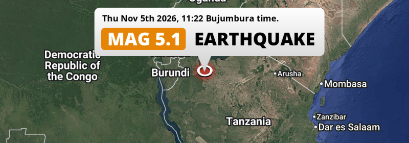
An unusually powerful M5.1 earthquake struck under land 21 kilometer from Ushirombo in Tanzania around noon of Thursday November 5th, 2026. Other nearby countries are Burundi and Rwanda.
Felt the earthquake? Share this article: 


Earthquake Summary
The earthquake struck on land in Tanzania, 21 kilometer (13 mi) east of Ushirombo in Geita. The center of this earthquake had a very shallow depth of 10 km. Shallow earthquakes usually have a larger impact than earthquakes deep in the earth.
| Date and Time: | Nov 5, 2026 12:22 (Dar es Salaam Time) - Nov 5, 2026 09:22 Universal Time. |
|---|---|
| Location: | 21 km east of Ushirombo, Geita, Tanzania. Coordinates 3°27'51"S 32°8'56"E. |
| Map: | 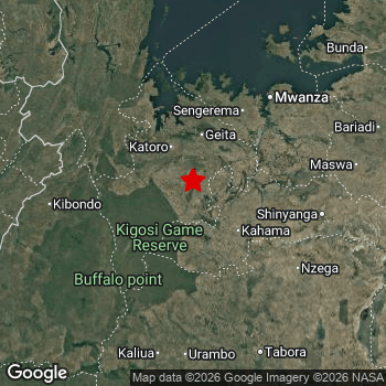 Map of area around epicenter. Click to open in Google Maps. |
| Magnitude: | MAG 5.1 Detected by 60 stations. Maximum Error Range ±0.073 . |
| Depth: | 10 km (6 mi) A very shallow depth. |
| Tsunami Risk: | Tsunami very unlikely While this was a shallow earthquake, it appears to have occurred under land with a magnitude not strong enough to cause tsunami's. Always stay cautious - More info here. |
Nearby towns and cities
This earthquake struck within proximity of multiple countries. Tanzania , Burundi and Rwanda are all within 300km distance of its epicenter.
The closest significant population center near the earthquake is Masumbwe in Geita, Tanzania. Masumbwe is located 19 kilometer (12 mi) north of the epicenter.
Major cities near this earthquake: Kigali is located 287 km to the northwest. Mwanza is located 134 km to the north-east. Tabora is located 188 km to the south-east.
An overview of nearby towns and cities is available in the overview below.
Overview of nearby places
| Distance | Place |
|---|---|
| 19 km (12 mi) S from epicenter |
Masumbwe Geita, Tanzania. |
| 21 km (13 mi) W from epicenter |
Ushirombo Geita, Tanzania. |
| 55 km (34 mi) NW from epicenter |
Buseresere Geita, Tanzania. |
| 57 km (35 mi) NW from epicenter |
Katoro Geita, Tanzania. |
| 65 km (40 mi) SE from epicenter |
Kahama Shinyanga, Tanzania. |
| 66 km (41 mi) N from epicenter |
Geita Geita, Tanzania. |
| 72 km (45 mi) W from epicenter |
Uyovu Geita, Tanzania. |
| 75 km (47 mi) NE from epicenter |
Kasamwa Geita, Tanzania. |
| 80 km (50 mi) E from epicenter |
Mhango Shinyanga, Tanzania. |
| 100 km (62 mi) SE from epicenter |
Isaka Shinyanga, Tanzania. |
| 101 km (63 mi) NW from epicenter |
Chato Geita, Tanzania. |
| 124 km (77 mi) NE from epicenter |
Misungwi Mwanza, Tanzania. |
| 126 km (78 mi) E from epicenter |
Tinde Shinyanga, Tanzania. |
| 128 km (80 mi) NE from epicenter |
Usagara Mwanza, Tanzania. |
| 131 km (81 mi) NW from epicenter |
Biharamulo Kagera, Tanzania. |
| 133 km (83 mi) W from epicenter |
Kakonko Kigoma, Tanzania. |
| 134 km (83 mi) NE from epicenter |
Mwanza Mwanza, Tanzania. |
| 139 km (86 mi) E from epicenter |
Old Shinyanga Shinyanga, Tanzania. |
| 142 km (88 mi) SE from epicenter |
Nzega Tabora, Tanzania. |
| 143 km (89 mi) E from epicenter |
Shinyanga Shinyanga, Tanzania. |
| 143 km (89 mi) NE from epicenter |
Ngudu Mwanza, Tanzania. |
| 152 km (94 mi) E from epicenter |
Songwa Shinyanga, Tanzania. |
| 158 km (98 mi) E from epicenter |
Malampaka Simiyu, Tanzania. |
| 159 km (99 mi) W from epicenter |
Kibondo Kigoma, Tanzania. |
| 161 km (100 mi) E from epicenter |
Mwadui Shinyanga, Tanzania. |
| 165 km (103 mi) NE from epicenter |
Kihangara Mwanza, Tanzania. |
| 179 km (111 mi) S from epicenter |
Urambo Tabora, Tanzania. |
| 184 km (114 mi) E from epicenter |
Nyalikungu Simiyu, Tanzania. |
| 185 km (115 mi) NE from epicenter |
Muriti Mara, Tanzania. |
| 188 km (117 mi) NW from epicenter |
Rulenge Kagera, Tanzania. |
| 188 km (117 mi) SE from epicenter |
Tabora Tabora, Tanzania. |
| 190 km (118 mi) S from epicenter |
Mabama Tabora, Tanzania. |
| 190 km (118 mi) S from epicenter |
Tumbi Tabora, Tanzania. |
| 191 km (119 mi) E from epicenter |
Kishapu Shinyanga, Tanzania. |
| 192 km (119 mi) W from epicenter |
Bugarama Kagera, Tanzania. |
| 197 km (122 mi) N from epicenter |
Nshamba Kagera, Tanzania. |
| 197 km (122 mi) NW from epicenter |
Ngara Kagera, Tanzania. |
| 200 km (124 mi) E from epicenter |
Lalago Simiyu, Tanzania. |
| 200 km (124 mi) E from epicenter |
Somanda Simiyu, Tanzania. |
| 211 km (131 mi) W from epicenter |
Ruyigi Ruyigi, Burundi. |
| 212 km (132 mi) W from epicenter |
Muyinga Muyinga, Burundi. |
| 213 km (132 mi) SE from epicenter |
Igunga Tabora, Tanzania. |
| 217 km (135 mi) E from epicenter |
Bariadi Simiyu, Tanzania. |
| 220 km (137 mi) SW from epicenter |
Nguruka Kigoma, Tanzania. |
| 230 km (143 mi) NW from epicenter |
Kibungo Eastern Province, Rwanda. |
| 240 km (149 mi) N from epicenter |
Bukoba Kagera, Tanzania. |
| 245 km (152 mi) W from epicenter |
Rutana Rutana, Burundi. |
| 247 km (153 mi) W from epicenter |
Gitega Gitega, Burundi. |
| 249 km (155 mi) SE from epicenter |
Shelui Singida, Tanzania. |
| 250 km (155 mi) NE from epicenter |
Bunda Mara, Tanzania. |
| 254 km (158 mi) NW from epicenter |
Rwamagana Eastern Province, Rwanda. |
| 265 km (165 mi) W from epicenter |
Ngozi Ngozi, Burundi. |
| 271 km (168 mi) W from epicenter |
Makamba Makamba, Burundi. |
| 283 km (176 mi) W from epicenter |
Muramvya Muramvya, Burundi. |
| 284 km (176 mi) W from epicenter |
Butare Southern Province, Rwanda. |
| 285 km (177 mi) W from epicenter |
Bururi Bururi, Burundi. |
| 285 km (177 mi) NE from epicenter |
Musoma Mara, Tanzania. |
| 286 km (178 mi) W from epicenter |
Kayanza Kayanza, Burundi. |
| 287 km (178 mi) NW from epicenter |
Kigali Kigali, Rwanda. |
Risk of aftershocks?
We have not yet detected any foreshocks or aftershocks (MAG-2.5 or higher) within 100km (62 mi) of this earthquake.
Aftershocks are usually at least 1 order of magnitude less strong than main shocks. The more time passes, the smaller the chance and likely strength of any potential aftershocks.
The chance that a significant earthquake like this one is followed by an even larger earthquake is not so large. On average, scientists estimate a 94% chance that a major earthquake will not be followed by an even larger one. It is still adviced to be aware of this risk
Read: How to Stay Safe during an Earthquake (cdc.gov).This is an unusually powerful earthquake
No earthquake of this strength has struck this region for a long time. Our data goes back 10 years, and no earthquakes measuring a magnitude of 5.1 or higher have been detected within 300 km (186 mi) of this epicenter.
Tsunami very unlikely
While MAG-6.5+ earthquakes may cause tsunami's, it appears that the epicenter of this earthquake hit under land. In addition, the reported depth is deeper than 100km, making the risk of a tsunami even less likely. However always stay cautious and monitor advice from local authorities.
Tsunami Risk Factors
| Factor | Under Sea? | MAG-6.5 or stronger? | Shallow depth? |
|---|---|---|---|
| Explanation | Almost all tsunami's are caused by earthquakes with their epicenter under sea or very near the sea. However stay cautious in coastal areas as earthquakes on land may cause landslides into sea, potentially still causing a local tsunami. | Under MAG 6.5: Very unlikely to cause a tsunami. MAG 6.5 to 7.5: Destructive tsunami's do occur, but are uncommon. Likely to observe small sea level changes. MAG 7.6+: Earthquakes with these magnitudes might produce destructive tsunami's. |
Most destructive tsunami's are caused by shallow earthquakes with a depth between 0 and 100km under the surface of the earth. Deeper tsunami's are unlikely to displace to ocean floor. |
| This Earthquake | Not this earthquake. This earthquake appears to have struck on land far from any coast. |
Not this earthquake. This earthquake had a magnitude of 5.1. Earthquakes of this strength are unlikely to trigger a tsunami. |
This earthquake occurred at a depth of of 10 km (6 mi). Earthquakes this shallow could trigger a tsunami. |
Sources
Last updated 05/11/26 13:58 (). As more information on this earthquake becomes available this article will be updated. This article is automatically composed based on data originating from multiple sources.
- US Geographic Society (USGS): Earthquake us7000tw76
- European-Mediterranean Seismological Centre (EMSC): Earthquake 20261105_0000124
- Geonames.org: World Cities Database
- Google Maps: Static API
- Earthquakelist.org: Historic Earthquakes Database
Share this article:
