
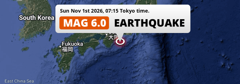
In the morning of Sunday November 1st, 2026, a strong M6.0 earthquake hit in the Philippine Sea 78 kilometer from Ise, Japan. Around 1.4 million people have been exposed to shaking.
Felt the earthquake? Share this article: 


Earthquake Summary
This earthquake hit under water in the Philippine Sea, 49 kilometers (31 mi) off the coast of Japan, 78 kilometer south of Ise in Mie. The center of this earthquake had a deep depth of 352 km.
| Date and Time: | Nov 1, 2026 07:15 (Tokyo Time) - Oct 31, 2026 22:15 Universal Time. |
|---|---|
| Location: | 78 km south of Ise, Mie, Japan. Coordinates 33°49'19"N 136°59'7"E. |
| Map: | 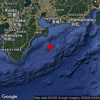 Map of area around epicenter. Click to open in Google Maps. |
| Magnitude: | MAG 6.0 Detected by 28 stations. Maximum Error Range ±0.059 . |
| Depth: | 352 km (219 mi) A deep depth. |
| Max. Intensity: | III
Weak On the Modified Mercalli Scale. |
| Tsunami Risk: | Tsunami very unlikely Earthquakes under MAG-6.5 at depths deeper than 100km are very unlikely to cause tsunami's. Always stay cautious - More info here. |
Minimal impact predicted
Based on scientific estimates by the US Geographic Survey (USGS), the risk of high fatalities for this earthquake is classified at level GREEN (low). They expect an 90% likelyhood of between 0 and 1 fatalities.
The USGS classifies the economic impact of this earthquake at level GREEN (low). They expect an 90% likelyhood of between 0 and 1 million US Dollars in economic damage and impact.
Roughly 1.4 million people exposed to shaking
An estimated 1.4 million have been exposed to shaking (An MMI or Modified Mercalli Intensity level II or higher) as a result of this earthquake according scientific estimates published by the USGS.
The highest earthquake impact level for this earthquake is III, which corresponds with weak shaking and probably no damage. Roughly 1,055,000 people are expected to be exposed to this level. All exposure to shaking was within the borders of Japan .
| People | MMI Level | Shaking | Damage |
|---|---|---|---|
| 0 | I |
Not noticable | None |
| 306,500 | II |
Very weak | None |
| 1,055,000 | III |
Weak | Probably none |
| 0 | IV |
Light | Likely none |
| 0 | V |
Moderate | Very light |
| 0 | VI |
Strong | Light |
| 0 | VII |
Very Strong | Moderate |
| 0 | VIII |
Severe | Moderate to heavy |
| 0 | IX |
Violent | Heavy |
| 0 | X |
Extreme | Very heavy |
Nearby towns and cities
This earthquake may have been felt in Japan . Toba in Mie, Japan is the nearest significant place from the epicenter. The earthquake occurred 75 kilometer (47 mi) south of Toba. The intensity of shaking and damage in Toba is estimated to be around level III on the Modified Mercalli Intensity scale (weak shaking, probably no damage).
Multiple major population centers exist within 300km of the earthquake that struck today. Tokyo is located 323 km to the north-east (intensity unknown, possibly low). Osaka is located 167 km to the northwest (intensity unknown, possibly low). Nagoya is located 151 km to the north (intensity unknown, possibly low).
A complete list of nearby places is included below. Estimated intensity data (MMI) sourced from a shake-map published by the US Geographic Survey is shown where available (cities without data probably experienced little impact).
Overview of nearby places
| Distance | Place | Intensity (MMI) |
|---|---|---|
| 75 km (47 mi) N from epicenter |
Toba Mie, Japan. |
III
Weak |
| 77 km (48 mi) W from epicenter |
Owase Mie, Japan. |
III
Weak |
| 78 km (48 mi) N from epicenter |
Ise Mie, Japan. |
III
Weak |
| 93 km (58 mi) W from epicenter |
Shingū Wakayama, Japan. |
II
Weak |
| 97 km (60 mi) N from epicenter |
Tahara Aichi, Japan. |
III
Weak |
| 99 km (62 mi) N from epicenter |
Toyohama Aichi, Japan. |
III
Weak |
| 110 km (68 mi) NW from epicenter |
Tsu Mie, Japan. |
|
| 111 km (69 mi) N from epicenter |
Toyohashi Aichi, Japan. |
|
| 115 km (71 mi) N from epicenter |
Gamagōri Aichi, Japan. |
|
| 116 km (72 mi) N from epicenter |
Nishio Aichi, Japan. |
|
| 117 km (73 mi) N from epicenter |
Toyokawa Aichi, Japan. |
|
| 118 km (73 mi) N from epicenter |
Handa Aichi, Japan. |
|
| 119 km (74 mi) NE from epicenter |
Hamamatsu Shizuoka, Japan. |
III
Weak |
| 121 km (75 mi) NW from epicenter |
Nabari Mie, Japan. |
II
Weak |
| 124 km (77 mi) N from epicenter |
Suzuka Mie, Japan. |
|
| 127 km (79 mi) N from epicenter |
Anjō Aichi, Japan. |
|
| 127 km (79 mi) N from epicenter |
Okazaki Aichi, Japan. |
|
| 129 km (80 mi) N from epicenter |
Kariya Aichi, Japan. |
|
| 132 km (82 mi) N from epicenter |
Yokkaichi Mie, Japan. |
|
| 134 km (83 mi) NW from epicenter |
Kashihara-shi Nara, Japan. |
|
| 140 km (87 mi) N from epicenter |
Kuwana Mie, Japan. |
|
| 141 km (88 mi) N from epicenter |
Toyota Aichi, Japan. |
|
| 145 km (90 mi) NW from epicenter |
Nara-shi Nara, Japan. |
|
| 148 km (92 mi) NW from epicenter |
Tondabayashichō Ōsaka, Japan. |
|
| 151 km (94 mi) N from epicenter |
Nagoya Aichi, Japan. |
|
| 155 km (96 mi) NW from epicenter |
Yao Ōsaka, Japan. |
|
| 159 km (99 mi) N from epicenter |
Kasugai Aichi, Japan. |
|
| 161 km (100 mi) NW from epicenter |
Izumi Ōsaka, Japan. |
|
| 161 km (100 mi) NW from epicenter |
Uji Kyoto, Japan. |
|
| 163 km (101 mi) NW from epicenter |
Neyagawa Ōsaka, Japan. |
|
| 163 km (101 mi) N from epicenter |
Komaki Aichi, Japan. |
|
| 163 km (101 mi) NW from epicenter |
Sakai Ōsaka, Japan. |
|
| 165 km (103 mi) NW from epicenter |
Kishiwada Ōsaka, Japan. |
|
| 165 km (103 mi) N from epicenter |
Ichinomiya Aichi, Japan. |
|
| 165 km (103 mi) NW from epicenter |
Hirakata Ōsaka, Japan. |
|
| 166 km (103 mi) NW from epicenter |
Ōtsu Shiga, Japan. |
|
| 167 km (104 mi) NW from epicenter |
Osaka Ōsaka, Japan. |
|
| 170 km (106 mi) NW from epicenter |
Takatsuki Ōsaka, Japan. |
|
| 171 km (106 mi) NW from epicenter |
Ibaraki Ōsaka, Japan. |
|
| 171 km (106 mi) NW from epicenter |
Suita Ōsaka, Japan. |
|
| 174 km (108 mi) W from epicenter |
Wakayama Wakayama, Japan. |
|
| 175 km (109 mi) NW from epicenter |
Toyonaka Ōsaka, Japan. |
|
| 175 km (109 mi) NW from epicenter |
Amagasaki Hyōgo, Japan. |
|
| 175 km (109 mi) W from epicenter |
Minato Wakayama, Japan. |
|
| 175 km (109 mi) NW from epicenter |
Kyoto Kyoto, Japan. |
|
| 179 km (111 mi) N from epicenter |
Gifu-shi Gifu, Japan. |
|
| 181 km (112 mi) NW from epicenter |
Itami Hyōgo, Japan. |
|
| 182 km (113 mi) NW from epicenter |
Nishinomiya-hama Hyōgo, Japan. |
|
| 182 km (113 mi) NE from epicenter |
Shizuoka Shizuoka, Japan. |
|
| 185 km (115 mi) NW from epicenter |
Takarazuka Hyōgo, Japan. |
|
| 192 km (119 mi) NW from epicenter |
Kobe Hyōgo, Japan. |
|
| 225 km (140 mi) W from epicenter |
Tokushima Tokushima, Japan. |
|
| 251 km (156 mi) NE from epicenter |
Kōfu Yamanashi, Japan. |
|
| 259 km (161 mi) N from epicenter |
Fukui-shi Fukui, Japan. |
|
| 276 km (171 mi) W from epicenter |
Takamatsu Kagawa, Japan. |
|
| 283 km (176 mi) N from epicenter |
Matsumoto Nagano, Japan. |
|
| 295 km (183 mi) NE from epicenter |
Hachiōji Tokyo, Japan. |
|
| 295 km (183 mi) W from epicenter |
Okayama Okayama, Japan. |
|
| 303 km (188 mi) NE from epicenter |
Yokohama Kanagawa, Japan. |
|
| 311 km (193 mi) N from epicenter |
Kanazawa Ishikawa, Japan. |
|
| 313 km (194 mi) NW from epicenter |
Tottori Tottori, Japan. |
|
| 321 km (199 mi) W from epicenter |
Kochi Kōchi, Japan. |
|
| 321 km (199 mi) N from epicenter |
Toyama Toyama, Japan. |
|
| 336 km (209 mi) NE from epicenter |
Saitama Saitama, Japan. |
|
| 341 km (212 mi) W from epicenter |
Fukuyama Hirochima, Japan. |
|
| 344 km (214 mi) NE from epicenter |
Maebashi Gunma, Japan. |
|
| 348 km (216 mi) NE from epicenter |
Chiba Chiba, Japan. |
|
| 358 km (222 mi) NE from epicenter |
Ashikaga Tochigi, Japan. |
|
| 386 km (240 mi) NW from epicenter |
Yasugichō Shimane, Japan. |
|
| 387 km (240 mi) N from epicenter |
Jōetsu Niigata, Japan. |
|
| 388 km (241 mi) NE from epicenter |
Tsukuba Ibaraki, Japan. |
|
| 390 km (242 mi) W from epicenter |
Matsuyama Ehime, Japan. |
Earthquake Intensity Map
The graph below overlays a map of the region around the epicenter with earthquake intensity data provided by the US Geographic Survey. The highest intensity level detected for this earthquake is III.

Risk of aftershocks?
We have not yet detected any foreshocks or aftershocks (MAG-2.5 or higher) within 100km (62 mi) of this earthquake.
Earthquakes can create aftershocks. These are generally at least 1 magnitude lower than any main shock, and as time passes the chance and strength of aftershocks decreases.
In only six percent of cases, significant earthquakes are followed by a larger main shock, making the current earthquake a foreshock. While the chance of this happening is not so large, it is adviced to maintain cautiousness in the hours and days following a major earthquake.
Read: How to Stay Safe during an Earthquake (cdc.gov).This is the strongest earthquake in 4 years
Earthquakes of this strength are not so common in the region, but it's not the first time. This is the strongest earthquake to hit since November 14th, 2022, when a 6.1 magnitude earthquake hit 30 km (18 mi) further east. An even stronger magnitude 6.3 earthquake struck on July 27th, 2019.
In total, 2 earthquakes with a magnitude of 6 or higher have been registered within 300km (186 mi) of this epicenter in the past 10 years. This comes down to an average of once every 5 years.
Tsunami very unlikely
For a serious tsunami to occur, earthquakes usually need to have a magnitude of at least 6.5 and occur at a shallow depth of maximum 100km. Neither are the case with this earthquake. However always stay cautious and monitor advice from local authorities.
Tsunami Risk Factors
| Factor | Under Sea? | MAG-6.5 or stronger? | Shallow depth? |
|---|---|---|---|
| Explanation | Almost all tsunami's are caused by earthquakes with their epicenter under sea or very near the sea. However stay cautious in coastal areas as earthquakes on land may cause landslides into sea, potentially still causing a local tsunami. | Under MAG 6.5: Very unlikely to cause a tsunami. MAG 6.5 to 7.5: Destructive tsunami's do occur, but are uncommon. Likely to observe small sea level changes. MAG 7.6+: Earthquakes with these magnitudes might produce destructive tsunami's. |
Most destructive tsunami's are caused by shallow earthquakes with a depth between 0 and 100km under the surface of the earth. Deeper tsunami's are unlikely to displace to ocean floor. |
| This Earthquake | This earthquake appears to have struck under the sea. | Not this earthquake. This earthquake had a magnitude of 6. Earthquakes of this strength are unlikely to trigger a tsunami. |
Not this earthquake. This earthquake occurred at a depth of 352 km (219 mi). Earthquakes this deep in the earth are unlikely to trigger a tsunami. |
Sources
Last updated 02/11/26 09:08 (). As more information on this earthquake becomes available this article will be updated. This article is automatically composed based on data originating from multiple sources.
- US Geographic Society (USGS): Earthquake us7000tuku
- European-Mediterranean Seismological Centre (EMSC): Earthquake 20261031_0000288
- Geonames.org: World Cities Database
- Google Maps: Static API
- Earthquakelist.org: Historic Earthquakes Database
Share this article:
