
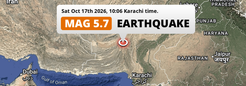
An unusually powerful MAG-5.7 earthquake struck under land 49 kilometer from Khuzdar in Pakistan in the morning of Saturday October 17th, 2026. Earthquakes like this can cause significant economic damage and have a significant risk at casualties.
Felt the earthquake? Share this article: 


Earthquake Summary
The earthquake struck on land in Pakistan, 49 kilometer (30 mi) northwest of Khuzdar in Balochistan. The center of this earthquake had a very shallow depth of 10 km. Shallow earthquakes usually have a larger impact than earthquakes deep in the earth.
| Date and Time: | Oct 17, 2026 10:06 (Karachi Time) - Oct 17, 2026 05:06 Universal Time. |
|---|---|
| Location: | 49 km NW of Khuzdar, Balochistan, Pakistan. Coordinates 28°1'4"N 66°10'15"E. |
| Map: | 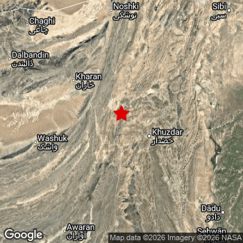 Map of area around epicenter. Click to open in Google Maps. |
| Magnitude: | MAG 5.7 Detected by 11 stations. Maximum Error Range ±0.093 . |
| Depth: | 10 km (6 mi) A very shallow depth. |
| Max. Intensity: | VIII
Severe On the Modified Mercalli Scale. |
| Tsunami Risk: | Tsunami very unlikely While this was a shallow earthquake, it appears to have occurred under land with a magnitude not strong enough to cause tsunami's. Always stay cautious - More info here. |
Significant impact predicted
Based on scientific estimates by the US Geographic Survey (USGS), the risk of high fatalities for this earthquake is classified at level YELLOW (significant). They expect an 50% likelyhood of between 0 and 1 fatalities, and a 97% chance that the number of fatalities falls no higher than 100.
The USGS classifies the economic impact of this earthquake at level YELLOW (significant). They expect an 39% likelyhood of between 1 and 10 million US Dollars in economic damage and impact, and a 96% chance that the economic impact of this earthquake falls no higher than 100 million USD.
Roughly 1 million people exposed to shaking
An estimated 1 million have been exposed to shaking (An MMI or Modified Mercalli Intensity level II or higher) as a result of this earthquake according scientific estimates published by the USGS.
An estimated 3,590 people were exposed to level VII. At this level, very strong shaking and likely moderate damage can be expected. Intensity level IV was experienced by the majority of people (around 0.8 million). In their region, light shaking and likely no damage can be expected. All exposure to shaking was within the borders of Pakistan .
| People | MMI Level | Shaking | Damage |
|---|---|---|---|
| 0 | I |
Not noticable | None |
| 0 | II |
Very weak | None |
| 14,010 | III |
Weak | Probably none |
| 819,600 | IV |
Light | Likely none |
| 163,000 | V |
Moderate | Very light |
| 35,100 | VI |
Strong | Light |
| 3,590 | VII |
Very Strong | Moderate |
| 0 | VIII |
Severe | Moderate to heavy |
| 0 | IX |
Violent | Heavy |
| 0 | X |
Extreme | Very heavy |
Nearby towns and cities
This earthquake may have been felt in Pakistan . Khuzdar in Balochistan, Pakistan is the nearest significant place from the epicenter. The earthquake occurred 49 kilometer (30 mi) northwest of Khuzdar. The intensity of shaking and damage in Khuzdar is estimated to be around level IV on the Modified Mercalli Intensity scale (light shaking, likely no damage).
Major cities near this earthquake: Quetta is located 254 km to the north (intensity unknown, possibly low). Khuzdar is located 49 km to the south-east and experienced an intensity of IV (light shaking, likely no damage). Larkana is located 207 km to the east (intensity unknown, possibly low).
A complete list of nearby places is included below. Estimated intensity data (MMI) sourced from a shake-map published by the US Geographic Survey is shown where available (cities without data probably experienced little impact).
Overview of nearby places
| Distance | Place | Intensity (MMI) |
|---|---|---|
| 49 km (30 mi) SE from epicenter |
Khuzdar Balochistan, Pakistan. |
IV
Light |
| 97 km (60 mi) NW from epicenter |
Kharan Balochistan, Pakistan. |
IV
Light |
| 120 km (75 mi) N from epicenter |
Kalat Balochistan, Pakistan. |
|
| 171 km (106 mi) N from epicenter |
Nushki Balochistan, Pakistan. |
|
| 172 km (107 mi) E from epicenter |
Shahdad Kot Sindh, Pakistan. |
|
| 172 km (107 mi) E from epicenter |
Warah Sindh, Pakistan. |
|
| 182 km (113 mi) E from epicenter |
Mehrabpur Balochistan, Pakistan. |
|
| 185 km (115 mi) E from epicenter |
Usta Muhammad Balochistan, Pakistan. |
|
| 185 km (115 mi) SE from epicenter |
Khairpur Nathan Shah Sindh, Pakistan. |
|
| 186 km (116 mi) E from epicenter |
Kambar Sindh, Pakistan. |
|
| 186 km (116 mi) E from epicenter |
Nasirabad Sindh, Pakistan. |
|
| 187 km (116 mi) SE from epicenter |
Mehar Sindh, Pakistan. |
|
| 198 km (123 mi) E from epicenter |
New Badah Sindh, Pakistan. |
|
| 198 km (123 mi) SE from epicenter |
Sita Road Sindh, Pakistan. |
|
| 198 km (123 mi) SE from epicenter |
Goth Radhan Sindh, Pakistan. |
|
| 200 km (124 mi) S from epicenter |
Bela Balochistan, Pakistan. |
|
| 205 km (127 mi) SE from epicenter |
Johi Sindh, Pakistan. |
|
| 207 km (129 mi) E from epicenter |
Larkana Sindh, Pakistan. |
|
| 209 km (130 mi) N from epicenter |
Mastung Balochistan, Pakistan. |
|
| 210 km (130 mi) E from epicenter |
Ratodero Sindh, Pakistan. |
|
| 214 km (133 mi) SE from epicenter |
Dadu Sindh, Pakistan. |
|
| 217 km (135 mi) NE from epicenter |
Dadhar Balochistan, Pakistan. |
|
| 219 km (136 mi) E from epicenter |
Naudero Sindh, Pakistan. |
|
| 223 km (139 mi) SE from epicenter |
Bhan Sindh, Pakistan. |
|
| 224 km (139 mi) E from epicenter |
Jacobabad Sindh, Pakistan. |
|
| 226 km (140 mi) SE from epicenter |
Tharu Shah Sindh, Pakistan. |
|
| 228 km (142 mi) SE from epicenter |
Kandiaro Sindh, Pakistan. |
|
| 233 km (145 mi) SE from epicenter |
Naushahro Firoz Sindh, Pakistan. |
|
| 234 km (145 mi) NE from epicenter |
Mach Balochistan, Pakistan. |
|
| 235 km (146 mi) SE from epicenter |
Moro Sindh, Pakistan. |
|
| 238 km (148 mi) NE from epicenter |
Sibi Balochistan, Pakistan. |
|
| 239 km (149 mi) E from epicenter |
Hingorja Sindh, Pakistan. |
|
| 242 km (150 mi) E from epicenter |
Shikarpur Sindh, Pakistan. |
|
| 243 km (151 mi) E from epicenter |
Setharja Old Sindh, Pakistan. |
|
| 243 km (151 mi) E from epicenter |
Gambat Sindh, Pakistan. |
|
| 244 km (152 mi) SE from epicenter |
Sehwan Sindh, Pakistan. |
|
| 244 km (152 mi) E from epicenter |
Ranipur Sindh, Pakistan. |
|
| 245 km (152 mi) E from epicenter |
Pir Jo Goth Sindh, Pakistan. |
|
| 252 km (157 mi) SE from epicenter |
Pad Idan Sindh, Pakistan. |
|
| 254 km (158 mi) N from epicenter |
Quetta Balochistan, Pakistan. |
|
| 256 km (159 mi) N from epicenter |
Kot Malik Barkhurdar Balochistan, Pakistan. |
|
| 257 km (160 mi) E from epicenter |
Thul Sindh, Pakistan. |
|
| 260 km (162 mi) E from epicenter |
Khairpur Mir’s Sindh, Pakistan. |
|
| 261 km (162 mi) E from epicenter |
Kot Diji Sindh, Pakistan. |
|
| 267 km (166 mi) E from epicenter |
Sukkur Sindh, Pakistan. |
|
| 270 km (168 mi) E from epicenter |
Rohri Sindh, Pakistan. |
|
| 286 km (178 mi) E from epicenter |
Ghauspur Sindh, Pakistan. |
|
| 289 km (180 mi) E from epicenter |
Pano Aqil Sindh, Pakistan. |
|
| 295 km (183 mi) SE from epicenter |
Sakrand Sindh, Pakistan. |
|
| 296 km (184 mi) E from epicenter |
Kandhkot Sindh, Pakistan. |
|
| 297 km (185 mi) SE from epicenter |
Nawabshah Sindh, Pakistan. |
Earthquake Intensity Map
The intensity in shaking and damage by this earthquake is illustrated through the map below. The highest intensity measured for this earthquake is VII.
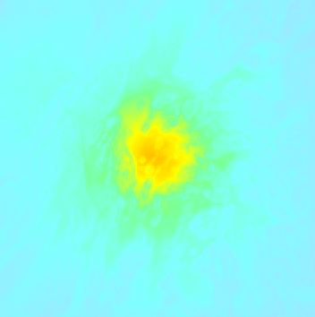
Shaking reported by 2 people
People that feel an earthquake may report their experience to the US Geographic Survey. Currently, 2 people have reported shaking in 2 places in Pakistan.We keep updating this article as more ground reports become available. You may report that you felt this earthquake here.
Places with most reports:
- Sūrāb, Baluchistan, Pakistan: 1 person.
- Karachi, Sind, Pakistan: 1 person.
Risk of aftershocks?
We have not yet detected any foreshocks or aftershocks (MAG-2.5 or higher) within 100km (62 mi) of this earthquake.
The risk of aftershocks decreases rapidly over time. Usually, aftershocks are at least one order of magnitude lower than a main shock.
It's always adviced to be cautious of the risk of a larger shock following any significant earthquake, however this risk is fairly small. There is a roughly 94 percent change that no larger main shock will follow in the days following this earthquake.
Read: How to Stay Safe during an Earthquake (cdc.gov).This is the strongest earthquake in 5 years
Earthquakes of this strength are not so common in the region, but it's not the first time. This is the strongest earthquake to hit since October 6th, 2021, when a 5.9 magnitude earthquake hit 300 km (186 mi) further north-east. That was also the heaviest earthquake to hit the region in the past 10 years.
In total, 1 earthquake with a magnitude of 5.7 or higher have been registered within 300km (186 mi) of this epicenter in the past 10 years. This comes down to an average of once every 10 years.
Tsunami very unlikely
While MAG-6.5+ earthquakes may cause tsunami's, it appears that the epicenter of this earthquake hit under land. In addition, the reported depth is deeper than 100km, making the risk of a tsunami even less likely. However always stay cautious and monitor advice from local authorities.
Tsunami Risk Factors
| Factor | Under Sea? | MAG-6.5 or stronger? | Shallow depth? |
|---|---|---|---|
| Explanation | Almost all tsunami's are caused by earthquakes with their epicenter under sea or very near the sea. However stay cautious in coastal areas as earthquakes on land may cause landslides into sea, potentially still causing a local tsunami. | Under MAG 6.5: Very unlikely to cause a tsunami. MAG 6.5 to 7.5: Destructive tsunami's do occur, but are uncommon. Likely to observe small sea level changes. MAG 7.6+: Earthquakes with these magnitudes might produce destructive tsunami's. |
Most destructive tsunami's are caused by shallow earthquakes with a depth between 0 and 100km under the surface of the earth. Deeper tsunami's are unlikely to displace to ocean floor. |
| This Earthquake | Not this earthquake. This earthquake appears to have struck on land far from any coast. |
Not this earthquake. This earthquake had a magnitude of 5.7. Earthquakes of this strength are unlikely to trigger a tsunami. |
This earthquake occurred at a depth of of 10 km (6 mi). Earthquakes this shallow could trigger a tsunami. |
Sources
Last updated 17/10/26 21:48 (). This article is automatically generated based on available data. We keep checking multiple sources for additional information. This article gets updated as new details on this earthquake become available.
- US Geographic Society (USGS): Earthquake us6000u2y1
- European-Mediterranean Seismological Centre (EMSC): Earthquake 20261017_0000062
- Geonames.org: World Cities Database
- Google Maps: Static API
- Earthquakelist.org: Historic Earthquakes Database
Share this article:
