
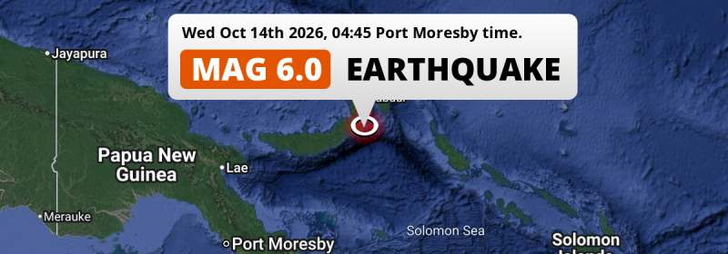
A shallow and strong M6.0 earthquake struck in the Solomon Sea 128 kilometer from Kokopo, Papua New Guinea in the night of Wednesday October 14th, 2026. Shaking may have been felt by a total of 60 thousand people.
Felt the earthquake? Share this article: 


Earthquake Summary
This earthquake hit under water in the Solomon Sea, right off the coast of Papua New Guinea (3 mi offshore), 128 kilometer south of Kokopo in East New Britain. The center of this earthquake had a very shallow depth of 21 km. Shallow earthquakes usually have a larger impact than earthquakes deep in the earth.
| Date and Time: | Oct 14, 2026 04:45 (Port Moresby Time) - Oct 13, 2026 18:45 Universal Time. |
|---|---|
| Location: | 128 km south of Kokopo, East New Britain, Papua New Guinea. Coordinates 5°28'60"S 152°8'11"E. |
| Map: | 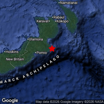 Map of area around epicenter. Click to open in Google Maps. |
| Magnitude: | MAG 6.0 Detected by 52 stations. Maximum Error Range ±0.043 . |
| Depth: | 21 km (13 mi) A very shallow depth. |
| Max. Intensity: | VI
Strong On the Modified Mercalli Scale. |
| Tsunami Risk: | Low tsunami risk Earthquakes under MAG-6.5 do not usually cause tsunami's. Always stay cautious - More info here. |
Minimal impact predicted
Based on scientific estimates by the US Geographic Survey (USGS), the risk of high fatalities for this earthquake is classified at level GREEN (low). They expect an 90% likelyhood of between 0 and 1 fatalities.
The USGS classifies the economic impact of this earthquake at level GREEN (low). They expect an 90% likelyhood of between 0 and 1 million US Dollars in economic damage and impact.
Roughly 60 thousand people exposed to shaking
The USGS has published a report estimating the number of people exposed to this earthquake. Acoording to their analysis, roughly 60 thousand have been exposed to shaking at an MMI level of II or higher.
An estimated 10 people were exposed to level VI. At this level, strong shaking and probably light damage can be expected. Intensity level IV was experienced by the majority of people (around 60 thousand). In their region, light shaking and likely no damage can be expected. All exposure to shaking was within the borders of Papua New Guinea .
| People | MMI Level | Shaking | Damage |
|---|---|---|---|
| 0 | I |
Not noticable | None |
| 0 | II |
Very weak | None |
| 3,430 | III |
Weak | Probably none |
| 55,000 | IV |
Light | Likely none |
| 5,770 | V |
Moderate | Very light |
| 10 | VI |
Strong | Light |
| 0 | VII |
Very Strong | Moderate |
| 0 | VIII |
Severe | Moderate to heavy |
| 0 | IX |
Violent | Heavy |
| 0 | X |
Extreme | Very heavy |
Nearby towns and cities
This earthquake may have been felt in Papua New Guinea . The closest significant population center near the earthquake is Kokopo in East New Britain, Papua New Guinea. Kokopo is located 128 kilometer (80 mi) south of the epicenter.
Overview of nearby places
| Distance | Place |
|---|---|
| 128 km (80 mi) N from epicenter |
Kokopo East New Britain, Papua New Guinea. |
| 221 km (137 mi) W from epicenter |
Kimbe West New Britain, Papua New Guinea. |
| 388 km (241 mi) E from epicenter |
Arawa Bougainville, Papua New Guinea. |
Earthquake Intensity Map
The graph below overlays a map of the region around the epicenter with earthquake intensity data provided by the US Geographic Survey. The highest intensity level detected for this earthquake is VI.

Shaking reported by 1 person
People that feel an earthquake may report their experience to the US Geographic Survey. Currently, 1 person has reported shaking in one place in Papua New Guinea.We keep updating this article as more ground reports become available. You may report that you felt this earthquake here.
Places with most reports:
- Kokopo, East New Britain, Papua New Guinea: 1 person.
Aftershocks detected
In the days before this main shock, 2 smaller foreshocks were detected. A 5.3 magnitude earthquake hit 4 hrs earlier nearby.
Overview of foreshocks and aftershocks
| Classification | Magnitude | When | Where |
|---|---|---|---|
| Foreshock | M 5.3 |
4 hrs earlier Oct 14, 2026 00:36 (Port Moresby Time) | 4 km (2.7 mi) N from Main Shock. |
| Foreshock | M 5.1 |
2 hrs earlier Oct 14, 2026 02:28 (Port Moresby Time) | 8 km (5 mi) N from Main Shock. |
| Main Shock This Earthquake |
M 6.0 |
Oct 14, 2026 04:45 (Port Moresby Time) | - |
More earthquakes coming?
Earthquakes can create aftershocks. These are generally at least 1 magnitude lower than any main shock, and as time passes the chance and strength of aftershocks decreases.
In only six percent of cases, significant earthquakes are followed by a larger main shock, making the current earthquake a foreshock. While the chance of this happening is not so large, it is adviced to maintain cautiousness in the hours and days following a major earthquake.
Read: How to Stay Safe during an Earthquake (cdc.gov).Earthquakes like this happen often in the region
Earthquakes of this strength are very common in the region. This is the strongest earthquake to hit since September 16th, 2025, when a 6 magnitude earthquake hit 177 km (110 mi) further east. An even stronger magnitude 7.9 earthquake struck on December 17th, 2016.
In total, 39 earthquakes with a magnitude of 6 or higher have been registered within 300km (186 mi) of this epicenter in the past 10 years. This comes down to an average of once every 3 months.
Low tsunami risk
Based on early data it appears this earthquake was not strong enough (lower than MAG-6.5) to be likely to cause destructive tsunami's. However this earthquake appeared to have hit at a shallow depth under sea, so stay cautious and monitor advice from local authorities.
Tsunami Risk Factors
| Factor | Under Sea? | MAG-6.5 or stronger? | Shallow depth? |
|---|---|---|---|
| Explanation | Almost all tsunami's are caused by earthquakes with their epicenter under sea or very near the sea. However stay cautious in coastal areas as earthquakes on land may cause landslides into sea, potentially still causing a local tsunami. | Under MAG 6.5: Very unlikely to cause a tsunami. MAG 6.5 to 7.5: Destructive tsunami's do occur, but are uncommon. Likely to observe small sea level changes. MAG 7.6+: Earthquakes with these magnitudes might produce destructive tsunami's. |
Most destructive tsunami's are caused by shallow earthquakes with a depth between 0 and 100km under the surface of the earth. Deeper tsunami's are unlikely to displace to ocean floor. |
| This Earthquake | This earthquake appears to have struck under the sea. | Not this earthquake. This earthquake had a magnitude of 6. Earthquakes of this strength are unlikely to trigger a tsunami. |
This earthquake occurred at a depth of of 21 km (13 mi). Earthquakes this shallow could trigger a tsunami. |
Sources
Last updated 13/10/26 22:28 (). As more information on this earthquake becomes available this article will be updated. This article is automatically composed based on data originating from multiple sources.
- US Geographic Society (USGS): Earthquake us6000u24c
- European-Mediterranean Seismological Centre (EMSC): Earthquake 20261013_0000368
- Geonames.org: World Cities Database
- Google Maps: Static API
- Earthquakelist.org: Historic Earthquakes Database
Share this article:
