
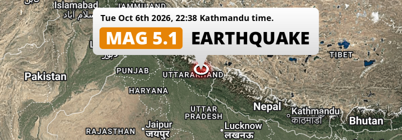
A shallow and significant MAG-5.1 earthquake struck under land 100 kilometer from Haldwani in India in the evening of Tuesday October 6th, 2026. Around 5.7 million people have been exposed to shaking. Nepal is also near its epicenter.
Felt the earthquake? Share this article: 


Earthquake Summary
The earthquake struck on land in India, 100 kilometer (62 mi) north of Haldwani in Uttarakhand. The center of this earthquake had a very shallow depth of 10 km. Shallow earthquakes usually have a larger impact than earthquakes deep in the earth.
| Date and Time: | Oct 6, 2026 22:23 (Kolkata Time) - Oct 6, 2026 16:53 Universal Time. |
|---|---|
| Location: | 100 km north of Haldwani, Uttarakhand, India. Coordinates 30°7'2"N 79°36'53"E. |
| Map: | 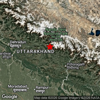 Map of area around epicenter. Click to open in Google Maps. |
| Magnitude: | MAG 5.1 Detected by 89 stations. Maximum Error Range ±0.06 . |
| Depth: | 10 km (6 mi) A very shallow depth. |
| Max. Intensity: | VI
Strong On the Modified Mercalli Scale. |
| Tsunami Risk: | Tsunami very unlikely While this was a shallow earthquake, it appears to have occurred under land with a magnitude not strong enough to cause tsunami's. Always stay cautious - More info here. |
Minimal impact predicted
Based on scientific estimates by the US Geographic Survey (USGS), the risk of high fatalities for this earthquake is classified at level GREEN (low). They expect an 90% likelyhood of between 0 and 1 fatalities.
The USGS classifies the economic impact of this earthquake at level GREEN (low). They expect an 90% likelyhood of between 0 and 1 million US Dollars in economic damage and impact.
Roughly 5.7 million people exposed to shaking
The USGS has published a report estimating the number of people exposed to this earthquake. Acoording to their analysis, roughly 5.7 million have been exposed to shaking at an MMI level of II or higher.
An estimated 26,490 people were exposed to level V. At this level, moderate shaking and very light damage can be expected. Intensity level III was experienced by the majority of people (around 4.9 million). In their region, weak shaking and probably no damage can be expected.
People in 3 countries have been exposed to shaking. In India , around 5.2 million people, with impact levels up to V (moderate shaking, very light damage). Roughly 440 thousand people were exposed to shaking in Nepal . In China, shaking was experienced too.
| People | MMI Level | Shaking | Damage |
|---|---|---|---|
| 0 | I |
Not noticable | None |
| 109,100 | II |
Very weak | None |
| 4,874,000 | III |
Weak | Probably none |
| 643,100 | IV |
Light | Likely none |
| 26,490 | V |
Moderate | Very light |
| 0 | VI |
Strong | Light |
| 0 | VII |
Very Strong | Moderate |
| 0 | VIII |
Severe | Moderate to heavy |
| 0 | IX |
Violent | Heavy |
| 0 | X |
Extreme | Very heavy |
Nearby towns and cities
This earthquake struck within proximity of multiple countries. India and Nepal are both within 300km distance of its epicenter.
Located 56 kilometer (35 mi) north of the epicenter of this earthquake, Rānikhet (Uttarakhand, India) is the nearest significant population center. The intensity of shaking and damage in Rānikhet is estimated to be around level III on the Modified Mercalli Intensity scale (weak shaking, probably no damage).
Multiple large cities are in proximity of today's earthquake. Delhi is located 283 km to the southwest (intensity unknown, possibly low). Meerut is located 224 km to the southwest (intensity unknown, possibly low). Ghāziābād is located 265 km to the southwest (intensity unknown, possibly low).
An overview of nearby towns and cities is available in the overview below. If places don't have intensity data available, it likely means the experienced impact in those places was fairly small.
Overview of nearby places
| Distance | Place | Intensity (MMI) |
|---|---|---|
| 56 km (35 mi) S from epicenter |
Rānikhet Uttarakhand, India. |
III
Weak |
| 58 km (36 mi) S from epicenter |
Almora Uttarakhand, India. |
III
Weak |
| 81 km (50 mi) W from epicenter |
Srīnagar Uttarakhand, India. |
III
Weak |
| 81 km (50 mi) W from epicenter |
Pauri Uttarakhand, India. |
III
Weak |
| 82 km (51 mi) S from epicenter |
Naini Tāl Uttarakhand, India. |
III
Weak |
| 83 km (52 mi) SE from epicenter |
Pithorāgarh Uttarakhand, India. |
III
Weak |
| 93 km (58 mi) SW from epicenter |
Rāmnagar Uttarakhand, India. |
III
Weak |
| 96 km (60 mi) E from epicenter |
Dārchulā Sudurpashchim Pradesh, Nepal. |
III
Weak |
| 100 km (62 mi) S from epicenter |
Haldwani Uttarakhand, India. |
III
Weak |
| 113 km (70 mi) W from epicenter |
Kotdwāra Uttarakhand, India. |
|
| 113 km (70 mi) W from epicenter |
Tehri Uttarakhand, India. |
|
| 119 km (74 mi) SW from epicenter |
Kashipur Uttarakhand, India. |
III
Weak |
| 120 km (75 mi) SW from epicenter |
Jaspur Uttarakhand, India. |
III
Weak |
| 126 km (78 mi) SW from epicenter |
Thakurdwara Uttar Pradesh, India. |
|
| 127 km (79 mi) W from epicenter |
Rishīkesh Uttarakhand, India. |
|
| 133 km (83 mi) SW from epicenter |
Sherkot Uttar Pradesh, India. |
|
| 135 km (84 mi) SW from epicenter |
Najībābād Uttar Pradesh, India. |
|
| 136 km (85 mi) SW from epicenter |
Nagīna Uttar Pradesh, India. |
|
| 139 km (86 mi) SE from epicenter |
Mahendranagar Sudurpashchim Pradesh, Nepal. |
|
| 139 km (86 mi) SW from epicenter |
Dhāmpur Uttar Pradesh, India. |
|
| 141 km (88 mi) S from epicenter |
Bīlāspur Uttar Pradesh, India. |
|
| 141 km (88 mi) W from epicenter |
Haridwar Uttarakhand, India. |
|
| 142 km (88 mi) SW from epicenter |
Seohāra Uttar Pradesh, India. |
III
Weak |
| 143 km (89 mi) SW from epicenter |
Tānda Uttar Pradesh, India. |
|
| 148 km (92 mi) SW from epicenter |
Nihtaur Uttar Pradesh, India. |
|
| 150 km (93 mi) S from epicenter |
Baheri Uttar Pradesh, India. |
|
| 152 km (94 mi) SW from epicenter |
Kīratpur Uttar Pradesh, India. |
|
| 154 km (96 mi) W from epicenter |
Dehra Dūn Uttarakhand, India. |
|
| 156 km (97 mi) S from epicenter |
Rāmpur Uttar Pradesh, India. |
|
| 164 km (102 mi) SW from epicenter |
Morādābād Uttar Pradesh, India. |
|
| 165 km (103 mi) SW from epicenter |
Bijnor Uttar Pradesh, India. |
|
| 166 km (103 mi) S from epicenter |
Pīlibhīt Uttar Pradesh, India. |
|
| 168 km (104 mi) W from epicenter |
Roorkee Uttarakhand, India. |
|
| 170 km (106 mi) SW from epicenter |
Chāndpur Uttar Pradesh, India. |
|
| 175 km (109 mi) SW from epicenter |
Amroha Uttar Pradesh, India. |
|
| 184 km (114 mi) SE from epicenter |
Dhangaḍhi̇̄ Sudurpashchim Pradesh, Nepal. |
|
| 192 km (119 mi) W from epicenter |
Deoband Uttar Pradesh, India. |
|
| 195 km (121 mi) S from epicenter |
Bareilly Uttar Pradesh, India. |
|
| 198 km (123 mi) SW from epicenter |
Sambhal Uttar Pradesh, India. |
|
| 198 km (123 mi) W from epicenter |
Muzaffarnagar Uttar Pradesh, India. |
|
| 200 km (124 mi) W from epicenter |
Sahāranpur Uttar Pradesh, India. |
|
| 224 km (139 mi) SW from epicenter |
Meerut Uttar Pradesh, India. |
|
| 250 km (155 mi) S from epicenter |
Shāhjānpur Uttar Pradesh, India. |
|
| 257 km (160 mi) SE from epicenter |
Birendranagar Karnali Pradesh, Nepal. |
|
| 259 km (161 mi) NW from epicenter |
Shimla Himachal Pradesh, India. |
|
| 265 km (165 mi) SW from epicenter |
Ghāziābād Uttar Pradesh, India. |
|
| 271 km (168 mi) SE from epicenter |
Gulariyā Lumbini Province, Nepal. |
|
| 280 km (174 mi) W from epicenter |
Chandīgarh Chandigarh, India. |
|
| 282 km (175 mi) SW from epicenter |
Narela Delhi, India. |
|
| 283 km (176 mi) SW from epicenter |
Delhi Delhi, India. |
|
| 284 km (176 mi) W from epicenter |
Mohali Punjab, India. |
|
| 286 km (178 mi) SW from epicenter |
Karol Bāgh Delhi, India. |
|
| 290 km (180 mi) SW from epicenter |
Alīgarh Uttar Pradesh, India. |
|
| 290 km (180 mi) SW from epicenter |
Rohini Delhi, India. |
|
| 293 km (182 mi) SW from epicenter |
Faridabad Haryana, India. |
Earthquake Intensity Map
The graph below overlays a map of the region around the epicenter with earthquake intensity data provided by the US Geographic Survey. The highest intensity level detected for this earthquake is V.

Shaking reported by 44 people
People that feel an earthquake may report their experience to the US Geographic Survey. Currently, 44 people have reported shaking in 31 places, all within India.We keep updating this article as more ground reports become available. You may report that you felt this earthquake here.
Places with most reports:
- Haldwani cum Kathgodam, Uttaranchal, India: 5 people.
- Srīnagar, Uttaranchal, India: 4 people.
- Bhowali, Uttaranchal, India: 3 people.
- Almora, Uttaranchal, India: 2 people.
- Khatīma, Uttaranchal, India: 2 people.
- Kotdwara, Uttaranchal, India: 2 people.
- Ni Dilli, Delhi, India: 2 people.
- Tehri, Uttaranchal, India: 1 person.
- Bhimtal, Uttaranchal, India: 1 person.
- Dhanaura, Uttar Pradesh, India: 1 person.
Risk of aftershocks?
We monitor for foreshocks or aftershocks that have a magnitude of 2.5+ and occur within 100km (62 mi) of the epicenter of this earthquake. So far no such earthquakes have been detected.
Earthquakes can create aftershocks. These are generally at least 1 magnitude lower than any main shock, and as time passes the chance and strength of aftershocks decreases.
In only six percent of cases, significant earthquakes are followed by a larger main shock, making the current earthquake a foreshock. While the chance of this happening is not so large, it is adviced to maintain cautiousness in the hours and days following a major earthquake.
Read: How to Stay Safe during an Earthquake (cdc.gov).This is the strongest earthquake in 3 years
Earthquakes of this strength occur quite regularly in the region. This is the strongest earthquake to hit since November 6th, 2023, when a 5.3 magnitude earthquake hit 275 km (171 mi) further south-east. An even stronger magnitude 5.7 earthquake struck on November 3rd, 2023.
In total, 7 earthquakes with a magnitude of 5.1 or higher have been registered within 300km (186 mi) of this epicenter in the past 10 years. This comes down to an average of once every year.
Tsunami very unlikely
While MAG-6.5+ earthquakes may cause tsunami's, it appears that the epicenter of this earthquake hit under land. In addition, the reported depth is deeper than 100km, making the risk of a tsunami even less likely. However always stay cautious and monitor advice from local authorities.
Tsunami Risk Factors
| Factor | Under Sea? | MAG-6.5 or stronger? | Shallow depth? |
|---|---|---|---|
| Explanation | Almost all tsunami's are caused by earthquakes with their epicenter under sea or very near the sea. However stay cautious in coastal areas as earthquakes on land may cause landslides into sea, potentially still causing a local tsunami. | Under MAG 6.5: Very unlikely to cause a tsunami. MAG 6.5 to 7.5: Destructive tsunami's do occur, but are uncommon. Likely to observe small sea level changes. MAG 7.6+: Earthquakes with these magnitudes might produce destructive tsunami's. |
Most destructive tsunami's are caused by shallow earthquakes with a depth between 0 and 100km under the surface of the earth. Deeper tsunami's are unlikely to displace to ocean floor. |
| This Earthquake | Not this earthquake. This earthquake appears to have struck on land far from any coast. |
Not this earthquake. This earthquake had a magnitude of 5.1. Earthquakes of this strength are unlikely to trigger a tsunami. |
This earthquake occurred at a depth of of 10 km (6 mi). Earthquakes this shallow could trigger a tsunami. |
Sources
Last updated 06/10/26 19:08 (). As more information on this earthquake becomes available this article will be updated. This article is automatically composed based on data originating from multiple sources.
- US Geographic Society (USGS): Earthquake us6000u0hz
- European-Mediterranean Seismological Centre (EMSC): Earthquake 20261006_0000229
- Geonames.org: World Cities Database
- Google Maps: Static API
- Earthquakelist.org: Historic Earthquakes Database
Share this article:
