
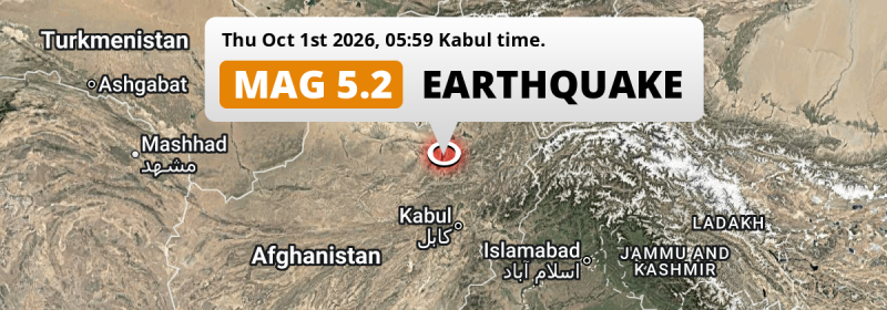
Under land 4 kilometer from Baghlān in Afghanistan, a significant M5.0 earthquake occurred in the early morning of Thursday October 1st, 2026. Other countries near the epicenter include Tajikistan and Uzbekistan.
Felt the earthquake? Share this article: 


Earthquake Summary
The earthquake struck on land in Afghanistan, 4 kilometer (2 mi) south-east of Baghlān in Baghlan. The center of this earthquake had a quite shallow depth of 55 km. Shallow earthquakes usually have a larger impact than earthquakes deep in the earth.
| Date and Time: | Oct 1, 2026 05:59AM (Kabul Time) - Oct 1, 2026 01:29 Universal Time. |
|---|---|
| Location: | 4 km SE of Baghlān, Baghlan, Afghanistan. Coordinates 36°6'28"N 68°44'37"E. |
| Map: | 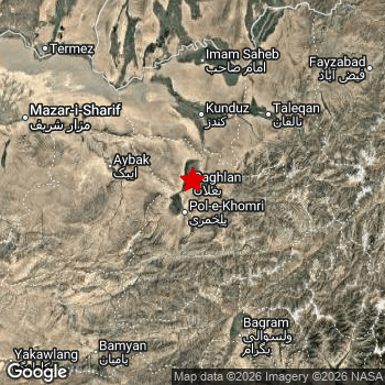 Map of area around epicenter. Click to open in Google Maps. |
| Magnitude: | MAG 5.0 Detected by 9 stations. Maximum Error Range ±0.103 . |
| Depth: | 55 km (34 mi) A quite shallow depth. |
| Tsunami Risk: | Tsunami very unlikely While this was a shallow earthquake, it appears to have occurred under land with a magnitude not strong enough to cause tsunami's. Always stay cautious - More info here. |
Nearby towns and cities
3 countries can be found within 300km of the epicenter of this earthquake: Afghanistan , Tajikistan and Uzbekistan .
The closest significant population center near the earthquake is Baghlān in Baghlan, Afghanistan. Baghlān is located 4 kilometer (2 mi) south-east of the epicenter.
Multiple large cities are in proximity of today's earthquake. Baghlān is located 4 km to the northwest. Kabul is located 180 km to the south. Dushanbe is located 270 km to the north.
A complete list of nearby places is included below.
Overview of nearby places
| Distance | Place |
|---|---|
| 4 km (2 mi) NW from epicenter |
Baghlān Baghlan, Afghanistan. |
| 18 km (11 mi) S from epicenter |
Pul-e Khumrī Baghlan, Afghanistan. |
| 35 km (22 mi) E from epicenter |
Nahrīn Baghlan, Afghanistan. |
| 68 km (42 mi) W from epicenter |
Aībak Samangan, Afghanistan. |
| 70 km (43 mi) N from epicenter |
Kunduz Kunduz, Afghanistan. |
| 72 km (45 mi) NE from epicenter |
Khanabad Kunduz, Afghanistan. |
| 99 km (62 mi) NE from epicenter |
Taloqan Takhar, Afghanistan. |
| 113 km (70 mi) SE from epicenter |
Bāzārak Panjshir, Afghanistan. |
| 114 km (71 mi) NW from epicenter |
Khulm Balkh, Afghanistan. |
| 119 km (74 mi) SE from epicenter |
Jabal os Saraj Parwan, Afghanistan. |
| 124 km (77 mi) N from epicenter |
Qarāwul Kunduz, Afghanistan. |
| 127 km (79 mi) NE from epicenter |
Ārt Khwājah Takhar, Afghanistan. |
| 128 km (80 mi) S from epicenter |
Charikar Parwan, Afghanistan. |
| 149 km (93 mi) NE from epicenter |
Rustāq Takhar, Afghanistan. |
| 161 km (100 mi) NW from epicenter |
Mazār-e Sharīf Balkh, Afghanistan. |
| 165 km (103 mi) N from epicenter |
Kolkhozobod Khatlon, Tajikistan. |
| 165 km (103 mi) N from epicenter |
Farkhor Khatlon, Tajikistan. |
| 165 km (103 mi) SW from epicenter |
Bāmyān Bamyan, Afghanistan. |
| 168 km (104 mi) N from epicenter |
Moskovskiy Khatlon, Tajikistan. |
| 170 km (106 mi) S from epicenter |
Paghmān Kabul, Afghanistan. |
| 179 km (111 mi) N from epicenter |
Vakhsh Khatlon, Tajikistan. |
| 180 km (112 mi) NW from epicenter |
Balkh Balkh, Afghanistan. |
| 180 km (112 mi) NW from epicenter |
Tirmiz Surxondaryo, Uzbekistan. |
| 180 km (112 mi) S from epicenter |
Kabul Kabul, Afghanistan. |
| 188 km (117 mi) NE from epicenter |
Chubek Khatlon, Tajikistan. |
| 192 km (119 mi) N from epicenter |
Bokhtar Khatlon, Tajikistan. |
| 199 km (124 mi) NE from epicenter |
Fayzabad Badakhshan, Afghanistan. |
| 205 km (127 mi) N from epicenter |
Hulbuk Khatlon, Tajikistan. |
| 208 km (129 mi) SE from epicenter |
Mehtar Lām Laghman, Afghanistan. |
| 210 km (130 mi) W from epicenter |
Sang-e Chārak Sar-e Pol, Afghanistan. |
| 221 km (137 mi) NE from epicenter |
Kŭlob Khatlon, Tajikistan. |
| 221 km (137 mi) SW from epicenter |
Bāzār-e Yakāwlang Bamyan, Afghanistan. |
| 227 km (141 mi) N from epicenter |
Danghara Khatlon, Tajikistan. |
| 227 km (141 mi) N from epicenter |
Sho‘rchi Surxondaryo, Uzbekistan. |
| 239 km (149 mi) S from epicenter |
Baraki Barak Logar, Afghanistan. |
| 243 km (151 mi) SE from epicenter |
Jalālābād Nangarhar, Afghanistan. |
| 247 km (153 mi) N from epicenter |
Yovon Khatlon, Tajikistan. |
| 252 km (157 mi) N from epicenter |
Denov Surxondaryo, Uzbekistan. |
| 253 km (157 mi) W from epicenter |
Sar-e Pul Sar-e Pol, Afghanistan. |
| 257 km (160 mi) SE from epicenter |
Asadābād Kunar, Afghanistan. |
| 262 km (163 mi) N from epicenter |
Boshkengash Dushanbe, Tajikistan. |
| 266 km (165 mi) E from epicenter |
Ishqoshim Gorno-Badakhshan, Tajikistan. |
| 269 km (167 mi) N from epicenter |
Hisor Republican Subordination, Tajikistan. |
| 270 km (168 mi) NW from epicenter |
Boysun Surxondaryo, Uzbekistan. |
| 270 km (168 mi) N from epicenter |
Dushanbe Dushanbe, Tajikistan. |
| 271 km (168 mi) N from epicenter |
Tursunzoda Republican Subordination, Tajikistan. |
| 273 km (170 mi) N from epicenter |
Vahdat Republican Subordination, Tajikistan. |
| 275 km (171 mi) W from epicenter |
Shibirghān Jowzjan, Afghanistan. |
| 283 km (176 mi) S from epicenter |
Gardez Paktia, Afghanistan. |
| 286 km (178 mi) S from epicenter |
Ghazni Ghazni, Afghanistan. |
| 294 km (183 mi) NE from epicenter |
Khorugh Gorno-Badakhshan, Tajikistan. |
Shaking reported by 2 people
People that feel an earthquake may report their experience to the US Geographic Survey. Currently, 2 people have reported shaking in 2 places in Afghanistan.We keep updating this article as more ground reports become available. You may report that you felt this earthquake here.
Places with most reports:
- Kabul, Kabul, Afghanistan: 1 person.
- Mazar-e Sharif, Balẖ, Afghanistan: 1 person.
Risk of aftershocks?
This earthquake did not have any significant foreshocks nor aftershocks occurring within 100km (62 mi) of its epicenter.
Earthquakes can create aftershocks. These are generally at least 1 magnitude lower than any main shock, and as time passes the chance and strength of aftershocks decreases.
The chance that a significant earthquake like this one is followed by an even larger earthquake is not so large. On average, scientists estimate a 94% chance that a major earthquake will not be followed by an even larger one. It is still adviced to be aware of this risk
Read: How to Stay Safe during an Earthquake (cdc.gov).Earthquakes like this happen often in the region
Earthquakes of this strength are very common in the region. This is the strongest earthquake to hit since August 18th, 2026, when a 5.2 magnitude earthquake hit 177 km (110 mi) further east. An even stronger magnitude 6.5 earthquake struck on March 21st, 2023.
In total, 90 earthquakes with a magnitude of 5 or higher have been registered within 300km (186 mi) of this epicenter in the past 10 years. This comes down to an average of once every month.
Tsunami very unlikely
While MAG-6.5+ earthquakes may cause tsunami's, it appears that the epicenter of this earthquake hit under land. In addition, the reported depth is deeper than 100km, making the risk of a tsunami even less likely. However always stay cautious and monitor advice from local authorities.
Tsunami Risk Factors
| Factor | Under Sea? | MAG-6.5 or stronger? | Shallow depth? |
|---|---|---|---|
| Explanation | Almost all tsunami's are caused by earthquakes with their epicenter under sea or very near the sea. However stay cautious in coastal areas as earthquakes on land may cause landslides into sea, potentially still causing a local tsunami. | Under MAG 6.5: Very unlikely to cause a tsunami. MAG 6.5 to 7.5: Destructive tsunami's do occur, but are uncommon. Likely to observe small sea level changes. MAG 7.6+: Earthquakes with these magnitudes might produce destructive tsunami's. |
Most destructive tsunami's are caused by shallow earthquakes with a depth between 0 and 100km under the surface of the earth. Deeper tsunami's are unlikely to displace to ocean floor. |
| This Earthquake | Not this earthquake. This earthquake appears to have struck on land far from any coast. |
Not this earthquake. This earthquake had a magnitude of 5. Earthquakes of this strength are unlikely to trigger a tsunami. |
This earthquake occurred at a depth of of 55 km (34 mi). Earthquakes this shallow could trigger a tsunami. |
Sources
Last updated 22/10/26 02:18 (). This article is automatically generated based on available data. We keep checking multiple sources for additional information. This article gets updated as new details on this earthquake become available.
- US Geographic Society (USGS): Earthquake us6000tyny
- European-Mediterranean Seismological Centre (EMSC): Earthquake 20261001_0000024
- Geonames.org: World Cities Database
- Google Maps: Static API
- Earthquakelist.org: Historic Earthquakes Database
Share this article:
