
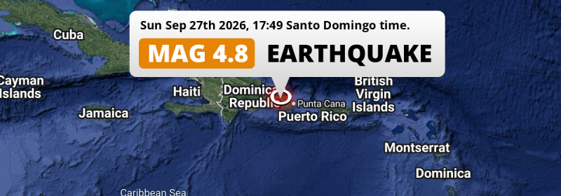
A MAG-4.8 earthquake struck under land 17 kilometer from La Romana in Dominican Republic in the late afternoon of Sunday September 27th, 2026. The earthquake struck near a very densely populated region. Another country near the epicenter is Puerto Rico.
Felt the earthquake? Share this article: 


Earthquake Summary
The earthquake struck on land in Dominican Republic, 17 kilometer (11 mi) northwest of La Romana. The center of this earthquake had an intermediate depth of 113 km.
| Date and Time: | Sep 27, 2026 05:49PM (Santo Domingo Time) - Sep 27, 2026 21:49 Universal Time. |
|---|---|
| Location: | 17 km NW of La Romana, Dominican Republic. Coordinates 18°33'51"N 69°2'28"W. |
| Map: | 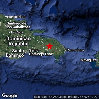 Map of area around epicenter. Click to open in Google Maps. |
| Magnitude: | MAG 4.8 Detected by 18 stations. Maximum Error Range ±0.11 . |
| Depth: | 113 km (70 mi) An intermediate depth. |
| Tsunami Risk: | Tsunami very unlikely Tsunami's are usually caused by MAG-6.5+ earthquakes, less than 100km shallow, and with an epicenter under sea. Neither of this seems to be the case. Always stay cautious - More info here. |
Nearby towns and cities
This earthquake struck within proximity of multiple countries. Dominican Republic and Puerto Rico are both within 300km distance of its epicenter.
La Romana in La Romana, Dominican Republic is the nearest significant place from the epicenter. The earthquake occurred 17 kilometer (11 mi) northwest of La Romana.
Multiple major population centers exist within 300km of the earthquake that struck today. Santo Domingo is located 90 km to the west. La Romana is located 17 km to the south-east. Santo Domingo Este is located 86 km to the west.
An overview of nearby towns and cities is available in the overview below.
Overview of nearby places
| Distance | Place |
|---|---|
| 17 km (11 mi) SE from epicenter |
La Romana La Romana, Dominican Republic. |
| 22 km (14 mi) N from epicenter |
Santa Cruz de El Seibo El Seíbo, Dominican Republic. |
| 31 km (19 mi) SW from epicenter |
San Pedro de Macorís San Pedro de Macorís, Dominican Republic. |
| 32 km (20 mi) NW from epicenter |
Hato Mayor del Rey Hato Mayor, Dominican Republic. |
| 36 km (22 mi) E from epicenter |
Salvaleón de Higüey La Altagracia, Dominican Republic. |
| 39 km (24 mi) W from epicenter |
Quisqueya San Pedro de Macorís, Dominican Republic. |
| 60 km (37 mi) W from epicenter |
Boca Chica Santo Domingo, Dominican Republic. |
| 66 km (41 mi) W from epicenter |
Bayaguana Monte Plata, Dominican Republic. |
| 67 km (42 mi) E from epicenter |
Punta Cana La Altagracia, Dominican Republic. |
| 83 km (52 mi) W from epicenter |
Monte Plata Monte Plata, Dominican Republic. |
| 86 km (53 mi) W from epicenter |
Santo Domingo Este Santo Domingo, Dominican Republic. |
| 90 km (56 mi) W from epicenter |
Santo Domingo Nacional, Dominican Republic. |
| 90 km (56 mi) W from epicenter |
Villa Francisca Nacional, Dominican Republic. |
| 90 km (56 mi) NW from epicenter |
Sabana Grande de Boyá Monte Plata, Dominican Republic. |
| 91 km (57 mi) W from epicenter |
Villa Consuelo Nacional, Dominican Republic. |
| 91 km (57 mi) W from epicenter |
Ciudad Nueva Nacional, Dominican Republic. |
| 96 km (60 mi) W from epicenter |
Bella Vista Nacional, Dominican Republic. |
| 101 km (63 mi) W from epicenter |
Santo Domingo Oeste Santo Domingo, Dominican Republic. |
| 106 km (66 mi) W from epicenter |
Bajos de Haina San Cristóbal, Dominican Republic. |
| 113 km (70 mi) W from epicenter |
San Cristóbal San Cristóbal, Dominican Republic. |
| 120 km (75 mi) W from epicenter |
Villa Altagracia San Cristóbal, Dominican Republic. |
| 124 km (77 mi) NW from epicenter |
Nagua María Trinidad Sánchez, Dominican Republic. |
| 129 km (80 mi) NW from epicenter |
Cotuí Sánchez Ramírez, Dominican Republic. |
| 140 km (87 mi) W from epicenter |
Baní Peravia, Dominican Republic. |
| 150 km (93 mi) W from epicenter |
Bonao Monseñor Nouel, Dominican Republic. |
| 151 km (94 mi) NW from epicenter |
San Francisco de Macorís Duarte, Dominican Republic. |
| 154 km (96 mi) W from epicenter |
San José de Ocoa San José de Ocoa, Dominican Republic. |
| 171 km (106 mi) NW from epicenter |
Salcedo Hermanas Mirabal, Dominican Republic. |
| 173 km (107 mi) NW from epicenter |
Concepción de La Vega La Vega, Dominican Republic. |
| 179 km (111 mi) W from epicenter |
Jarabacoa La Vega, Dominican Republic. |
| 179 km (111 mi) W from epicenter |
Azua Azua, Dominican Republic. |
| 181 km (112 mi) NW from epicenter |
Moca Espaillat, Dominican Republic. |
| 183 km (114 mi) W from epicenter |
Constanza La Vega, Dominican Republic. |
| 194 km (121 mi) NW from epicenter |
Tamboril Santiago, Dominican Republic. |
| 200 km (124 mi) E from epicenter |
Aguadilla Aguadilla, Puerto Rico. |
| 200 km (124 mi) NW from epicenter |
Santiago de los Caballeros Santiago, Dominican Republic. |
| 205 km (127 mi) E from epicenter |
Mayagüez Mayagüez, Puerto Rico. |
| 209 km (130 mi) NW from epicenter |
Monte Llano Puerto Plata, Dominican Republic. |
| 219 km (136 mi) NW from epicenter |
Río Grande Puerto Plata, Dominican Republic. |
| 220 km (137 mi) NW from epicenter |
Puerto Plata Puerto Plata, Dominican Republic. |
| 221 km (137 mi) W from epicenter |
Santa Cruz de Barahona Barahona, Dominican Republic. |
| 223 km (139 mi) NW from epicenter |
Villa Bisonó Santiago, Dominican Republic. |
| 232 km (144 mi) W from epicenter |
San Juan de la Maguana San Juan, Dominican Republic. |
| 234 km (145 mi) NW from epicenter |
Esperanza Valverde, Dominican Republic. |
| 239 km (149 mi) E from epicenter |
Yauco Yauco, Puerto Rico. |
| 241 km (150 mi) NW from epicenter |
Mao Valverde, Dominican Republic. |
| 245 km (152 mi) E from epicenter |
Arecibo Arecibo, Puerto Rico. |
| 251 km (156 mi) W from epicenter |
Neiba Baoruco, Dominican Republic. |
| 262 km (163 mi) W from epicenter |
Sabaneta Santiago Rodríguez, Dominican Republic. |
| 263 km (163 mi) E from epicenter |
Ponce Ponce, Puerto Rico. |
| 263 km (163 mi) W from epicenter |
Las Matas de Farfán San Juan, Dominican Republic. |
| 264 km (164 mi) E from epicenter |
Barceloneta Barceloneta, Puerto Rico. |
| 269 km (167 mi) E from epicenter |
Manatí Manatí, Puerto Rico. |
| 280 km (174 mi) E from epicenter |
Vega Baja Vega Baja, Puerto Rico. |
| 299 km (186 mi) E from epicenter |
Candelaria Toa Baja, Puerto Rico. |
Shaking reported by 126 people
People that feel an earthquake may report their experience to the US Geographic Survey. Currently, 126 people have reported shaking in 21 places, all within Dominican Republic.We keep updating this article as more ground reports become available. You may report that you felt this earthquake here.
Places with most reports:
- Santo Domingo, Santo Domingo, Dominican Republic: 77 people.
- El Carril, San Cristóbal, Dominican Republic: 17 people.
- Otra Banda, La Altagracia, Dominican Republic: 6 people.
- Santiago, Santiago, Dominican Republic: 6 people.
- Jarabacoa, La Vega, Dominican Republic: 2 people.
- San Cristóbal, San Cristóbal, Dominican Republic: 2 people.
- Los Llanos, San Pedro de Macorís, Dominican Republic: 2 people.
- Ramón Santana, San Pedro de Macorís, Dominican Republic: 1 person.
- Yamasá, Monte Plata, Dominican Republic: 1 person.
- Azua, Azua, Dominican Republic: 1 person.
6 Aftershocks detected
This main shock was followed by 6 smaller aftershocks. A 3.8 magnitude earthquake hit 13 hrs later 38 km (24 mi) south-east of this earthquake.
Before this earthquake struck, 2 smaller foreshocks occurred. A 4.2 magnitude earthquake hit 12 hrs earlier nearby.
Overview of foreshocks and aftershocks
| Classification | Magnitude | When | Where |
|---|---|---|---|
| Foreshock | M 4.2 |
12 hrs earlier Sep 27, 2026 06:07AM (Santo Domingo Time) | 70 km (43 mi) W from Main Shock. |
| Foreshock | M 3.1 |
3 hrs earlier Sep 27, 2026 03:09PM (Santo Domingo Time) | 70 km (43 mi) S from Main Shock. |
| Main Shock This Earthquake |
M 4.8 |
Sep 27, 2026 05:49PM (Santo Domingo Time) | - |
| Aftershock | M 3.4 |
3 hrs later Sep 27, 2026 09:05PM (Santo Domingo Time) | 36 km (22 mi) SE from Main Shock. |
| Aftershock | M 3.4 |
10 hrs later Sep 28, 2026 03:35AM (Santo Domingo Time) | 70 km (44 mi) SE from Main Shock. |
| Aftershock | M 3.8 |
13 hrs later Sep 28, 2026 06:54AM (Santo Domingo Time) | 38 km (24 mi) SE from Main Shock. |
| Aftershock | M 3.0 |
1 day later Sep 28, 2026 07:03PM (Santo Domingo Time) | 59 km (37 mi) NE from Main Shock. |
| Aftershock | M 3.4 |
1 day later Sep 28, 2026 09:46PM (Santo Domingo Time) | 21 km (13 mi) SE from Main Shock. |
| Aftershock | M 3.0 |
1 day later Sep 28, 2026 11:34PM (Santo Domingo Time) | 47 km (29 mi) W from Main Shock. |
More earthquakes coming?
The risk of aftershocks decreases rapidly over time. Usually, aftershocks are at least one order of magnitude lower than a main shock.
The chance that a significant earthquake like this one is followed by an even larger earthquake is not so large. On average, scientists estimate a 94% chance that a major earthquake will not be followed by an even larger one. It is still adviced to be aware of this risk
Read: How to Stay Safe during an Earthquake (cdc.gov).Earthquakes like this happen often in the region
Earthquakes of this strength are very common in the region. This is the strongest earthquake to hit since September 18th, 2026, when a 4.8 magnitude earthquake hit 232 km (144 mi) further east. An even stronger magnitude 6.4 earthquake struck on January 7th, 2020.
In total, 50 earthquakes with a magnitude of 4.8 or higher have been registered within 300km (186 mi) of this epicenter in the past 10 years. This comes down to an average of once every 2 months.
Tsunami very unlikely
It is very unlikely that this eartquake will cause any tsunami's. The reported magnitude is lower than the MAG-6.5 strength required to cause any earthquakes. In addition, this earthquake was not very shallow and appears to have occurred under land. However always stay cautious and monitor advice from local authorities.
Tsunami Risk Factors
| Factor | Under Sea? | MAG-6.5 or stronger? | Shallow depth? |
|---|---|---|---|
| Explanation | Almost all tsunami's are caused by earthquakes with their epicenter under sea or very near the sea. However stay cautious in coastal areas as earthquakes on land may cause landslides into sea, potentially still causing a local tsunami. | Under MAG 6.5: Very unlikely to cause a tsunami. MAG 6.5 to 7.5: Destructive tsunami's do occur, but are uncommon. Likely to observe small sea level changes. MAG 7.6+: Earthquakes with these magnitudes might produce destructive tsunami's. |
Most destructive tsunami's are caused by shallow earthquakes with a depth between 0 and 100km under the surface of the earth. Deeper tsunami's are unlikely to displace to ocean floor. |
| This Earthquake | This earthquake appears to have struck on land near a coastal area (18 km from the sea). | Not this earthquake. This earthquake had a magnitude of 4.8. Earthquakes of this strength are unlikely to trigger a tsunami. |
Not this earthquake. This earthquake occurred at a depth of 113 km (70 mi). Earthquakes this deep in the earth are unlikely to trigger a tsunami. |
Sources
Last updated 19/10/26 00:18 (). This article is automatically generated based on available data. We keep checking multiple sources for additional information. This article gets updated as new details on this earthquake become available.
- US Geographic Society (USGS): Earthquake us6000ty0q
- European-Mediterranean Seismological Centre (EMSC): Earthquake 20260927_0000285
- Geonames.org: World Cities Database
- Google Maps: Static API
- Earthquakelist.org: Historic Earthquakes Database
Share this article:
