
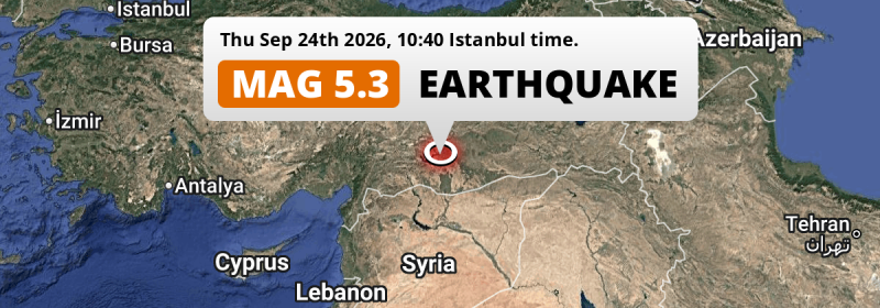
A shallow and significant MAG-5.1 earthquake struck under land 33 kilometer from Şanlıurfa in Türkiye in the morning of Thursday September 24th, 2026. Syria is also near its epicenter.
Felt the earthquake? Share this article: 


Earthquake Summary
The earthquake struck on land in Türkiye, 33 kilometer (21 mi) north of Şanlıurfa. The center of this earthquake had a very shallow depth of 10 km. Shallow earthquakes usually have a larger impact than earthquakes deep in the earth.
| Date and Time: | Sep 24, 2026 10:40 (Istanbul Time) - Sep 24, 2026 07:40 Universal Time. |
|---|---|
| Location: | 33 km north of Şanlıurfa, Türkiye. Coordinates 37°27'50"N 38°46'32"E. |
| Map: | 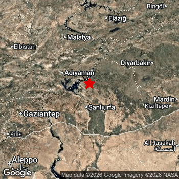 Map of area around epicenter. Click to open in Google Maps. |
| Magnitude: | MAG 5.1 Detected by 45 stations. Maximum Error Range ±0.046 . |
| Depth: | 10 km (6 mi) A very shallow depth. |
| Tsunami Risk: | Tsunami very unlikely While this was a shallow earthquake, it appears to have occurred under land with a magnitude not strong enough to cause tsunami's. Always stay cautious - More info here. |
Impact
The US Geographic Survey (USGS) describes the impact of this earthquake as follows:
Some people injured, several homes and buildings damaged in the Karakopru-Urfa area.
Nearby towns and cities
Türkiye and Syria are both located within 300km distance of the epicenter of the earthquake.
The closest significant population center near the earthquake is Hilvan in Şanlıurfa, Türkiye. Hilvan is located 21 kilometer (13 mi) southwest of the epicenter.
Multiple major population centers exist within 300km of the earthquake that struck today. Şanlıurfa is located 33 km to the south. Gaziantep is located 131 km to the west. Aleppo is located 201 km to the southwest.
A complete list of nearby places is included below.
Overview of nearby places
| Distance | Place |
|---|---|
| 21 km (13 mi) NE from epicenter |
Hilvan Şanlıurfa, Türkiye. |
| 25 km (16 mi) SW from epicenter |
Bozova Şanlıurfa, Türkiye. |
| 33 km (21 mi) S from epicenter |
Şanlıurfa Şanlıurfa, Türkiye. |
| 38 km (24 mi) N from epicenter |
Kâhta Adıyaman, Türkiye. |
| 55 km (34 mi) NW from epicenter |
Adıyaman Adıyaman, Türkiye. |
| 58 km (36 mi) NE from epicenter |
Siverek Şanlıurfa, Türkiye. |
| 62 km (39 mi) SW from epicenter |
Suruç Şanlıurfa, Türkiye. |
| 74 km (46 mi) SW from epicenter |
‘Ayn al ‘Arab Aleppo, Syria. |
| 85 km (53 mi) W from epicenter |
Besni Adıyaman, Türkiye. |
| 85 km (53 mi) S from epicenter |
Akçakale Şanlıurfa, Türkiye. |
| 86 km (53 mi) SW from epicenter |
Birecik Şanlıurfa, Türkiye. |
| 91 km (57 mi) E from epicenter |
Viranşehir Şanlıurfa, Türkiye. |
| 95 km (59 mi) NE from epicenter |
Çermik Diyarbakır, Türkiye. |
| 99 km (62 mi) SW from epicenter |
Jarābulus Aleppo, Syria. |
| 100 km (62 mi) SW from epicenter |
Nizip Gaziantep, Türkiye. |
| 106 km (66 mi) W from epicenter |
Gölbaşı Adıyaman, Türkiye. |
| 106 km (66 mi) NW from epicenter |
Malatya Malatya, Türkiye. |
| 123 km (76 mi) N from epicenter |
Baskil Elazığ, Türkiye. |
| 124 km (77 mi) NE from epicenter |
Ergani Diyarbakır, Türkiye. |
| 127 km (79 mi) SW from epicenter |
Manbij Aleppo, Syria. |
| 130 km (81 mi) W from epicenter |
Pazarcık Kahramanmaraş, Türkiye. |
| 131 km (81 mi) W from epicenter |
Gaziantep Gaziantep, Türkiye. |
| 132 km (82 mi) SE from epicenter |
Ceylanpınar Şanlıurfa, Türkiye. |
| 135 km (84 mi) W from epicenter |
Çağlayancerit Kahramanmaraş, Türkiye. |
| 136 km (85 mi) E from epicenter |
Diyarbakır Diyarbakır, Türkiye. |
| 140 km (87 mi) N from epicenter |
Elazığ Elazığ, Türkiye. |
| 161 km (100 mi) NW from epicenter |
Elbistan Kahramanmaraş, Türkiye. |
| 162 km (101 mi) E from epicenter |
Kızıltepe Mardin, Türkiye. |
| 164 km (102 mi) W from epicenter |
Kahramanmaraş Kahramanmaraş, Türkiye. |
| 165 km (103 mi) SW from epicenter |
Al Bāb Aleppo, Syria. |
| 166 km (103 mi) SW from epicenter |
Tādif Aleppo, Syria. |
| 169 km (105 mi) SW from epicenter |
Kilis Kilis, Türkiye. |
| 169 km (105 mi) S from epicenter |
Ar Raqqah Ar-Raqqah, Syria. |
| 171 km (106 mi) E from epicenter |
Bismil Diyarbakır, Türkiye. |
| 174 km (108 mi) SW from epicenter |
Dayr Ḩāfir Aleppo, Syria. |
| 175 km (109 mi) E from epicenter |
Mardin Mardin, Türkiye. |
| 181 km (112 mi) E from epicenter |
Yeşilli Mardin, Türkiye. |
| 182 km (113 mi) S from epicenter |
Ath Thawrah Ar-Raqqah, Syria. |
| 182 km (113 mi) SW from epicenter |
I‘zāz Aleppo, Syria. |
| 185 km (115 mi) NW from epicenter |
Afşin Kahramanmaraş, Türkiye. |
| 194 km (121 mi) N from epicenter |
Tunceli Tunceli, Türkiye. |
| 198 km (123 mi) SW from epicenter |
As Safīrah Aleppo, Syria. |
| 200 km (124 mi) SW from epicenter |
‘Afrīn Aleppo, Syria. |
| 201 km (125 mi) SW from epicenter |
Aleppo Aleppo, Syria. |
| 205 km (127 mi) SE from epicenter |
Al Ḩasakah Al-Hasakah, Syria. |
| 213 km (132 mi) E from epicenter |
Batman Batman, Türkiye. |
| 218 km (135 mi) NE from epicenter |
Bingöl Bingöl, Türkiye. |
| 228 km (142 mi) W from epicenter |
Osmaniye Osmaniye, Türkiye. |
| 251 km (156 mi) SW from epicenter |
İskenderun Hatay, Türkiye. |
| 256 km (159 mi) SW from epicenter |
Idlib Idlib, Syria. |
| 261 km (162 mi) N from epicenter |
Erzincan Erzincan, Türkiye. |
| 266 km (165 mi) W from epicenter |
Ceyhan Adana, Türkiye. |
| 266 km (165 mi) SE from epicenter |
Deir ez-Zor Deir ez-Zor, Syria. |
| 272 km (169 mi) SW from epicenter |
Antakya Hatay, Türkiye. |
| 275 km (171 mi) E from epicenter |
İdil Şırnak, Türkiye. |
| 276 km (171 mi) NE from epicenter |
Muş Muş, Türkiye. |
| 283 km (176 mi) E from epicenter |
Siirt Siirt, Türkiye. |
| 296 km (184 mi) NW from epicenter |
Sivas Sivas, Türkiye. |
Shaking reported by 10 people in 2 countries
People that feel an earthquake may report their experience to the US Geographic Survey. Currently, 10 people have reported shaking in 8 places in 2 countries (Turkey, Syria).We keep updating this article as more ground reports become available. You may report that you felt this earthquake here.
Places with most reports:
- Urfa, Şanliurfa, Turkey: 2 people.
- Gaziantep, Gaziantep, Turkey: 2 people.
- ar-Raqqah, ar-Raqqah, Syria: 1 person.
- Halfeti, Şanliurfa, Turkey: 1 person.
- Aleppo, H̨alab, Syria: 1 person.
- Mardin, Mardin, Turkey: 1 person.
- Ankara, Ankara, Turkey: 1 person.
- Adana, Adana, Turkey: 1 person.
2 Aftershocks detected
After this earthquake struck, 2 smaller aftershocks occurred. At a distance of 90 km (56 mi) north of this earthquake, an aftershock struck 4 hrs later. It measured a magnitude of 2.6
Before this earthquake struck, 1 smaller foreshock occurred. A 3.3 magnitude earthquake hit 2 days earlier nearby.
Overview of foreshocks and aftershocks
| Classification | Magnitude | When | Where |
|---|---|---|---|
| Foreshock | M 3.3 |
2 days earlier Sep 22, 2026 14:46 (Istanbul Time) | 85 km (53 mi) N from Main Shock. |
| Main Shock This Earthquake |
M 5.1 |
Sep 24, 2026 10:40 (Istanbul Time) | - |
| Aftershock | M 2.5 |
19 mins later Sep 24, 2026 10:59 (Istanbul Time) | 7 km (4 mi) E from Main Shock. |
| Aftershock | M 2.6 |
4 hrs later Sep 24, 2026 14:39 (Istanbul Time) | 90 km (56 mi) N from Main Shock. |
More earthquakes coming?
Earthquakes can create aftershocks. These are generally at least 1 magnitude lower than any main shock, and as time passes the chance and strength of aftershocks decreases.
The chance that a significant earthquake like this one is followed by an even larger earthquake is not so large. On average, scientists estimate a 94% chance that a major earthquake will not be followed by an even larger one. It is still adviced to be aware of this risk
Read: How to Stay Safe during an Earthquake (cdc.gov).Earthquakes like this happen often in the region
Earthquakes of this strength are very common in the region. This is the strongest earthquake to hit since May 20th, 2026, when a 5.4 magnitude earthquake hit 86 km (54 mi) further north. An even stronger magnitude 7.8 earthquake struck on February 6th, 2023.
In total, 41 earthquakes with a magnitude of 5.1 or higher have been registered within 300km (186 mi) of this epicenter in the past 10 years. This comes down to an average of once every 3 months.
Tsunami very unlikely
While MAG-6.5+ earthquakes may cause tsunami's, it appears that the epicenter of this earthquake hit under land. In addition, the reported depth is deeper than 100km, making the risk of a tsunami even less likely. However always stay cautious and monitor advice from local authorities.
Tsunami Risk Factors
| Factor | Under Sea? | MAG-6.5 or stronger? | Shallow depth? |
|---|---|---|---|
| Explanation | Almost all tsunami's are caused by earthquakes with their epicenter under sea or very near the sea. However stay cautious in coastal areas as earthquakes on land may cause landslides into sea, potentially still causing a local tsunami. | Under MAG 6.5: Very unlikely to cause a tsunami. MAG 6.5 to 7.5: Destructive tsunami's do occur, but are uncommon. Likely to observe small sea level changes. MAG 7.6+: Earthquakes with these magnitudes might produce destructive tsunami's. |
Most destructive tsunami's are caused by shallow earthquakes with a depth between 0 and 100km under the surface of the earth. Deeper tsunami's are unlikely to displace to ocean floor. |
| This Earthquake | Not this earthquake. This earthquake appears to have struck on land far from any coast. |
Not this earthquake. This earthquake had a magnitude of 5.1. Earthquakes of this strength are unlikely to trigger a tsunami. |
This earthquake occurred at a depth of of 10 km (6 mi). Earthquakes this shallow could trigger a tsunami. |
Sources
Last updated 16/10/26 01:38 (). As more information on this earthquake becomes available this article will be updated. This article is automatically composed based on data originating from multiple sources.
- US Geographic Society (USGS): Earthquake us6000tx9u
- European-Mediterranean Seismological Centre (EMSC): Earthquake 20260924_0000086
- Geonames.org: World Cities Database
- Google Maps: Static API
- Earthquakelist.org: Historic Earthquakes Database
Share this article:
