
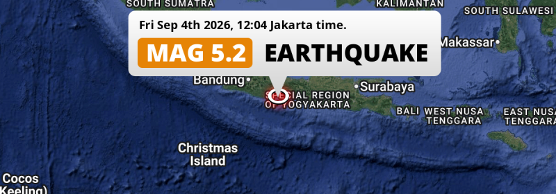
A significant M5.2 aftershock struck in the Indian Ocean 71 kilometer from Purwokerto, Indonesia around noon of Friday September 4th, 2026.
Felt the earthquake? Share this article: 


Earthquake Summary
This earthquake hit under water in the Indian Ocean, 36 kilometers (22 mi) off the coast of Indonesia, 71 kilometer south of Purwokerto in Central Java. The center of this earthquake had an intermediate depth of 79 km.
| Date and Time: | Sep 4, 2026 12:05 (Jakarta Time) - Sep 4, 2026 05:05 Universal Time. |
|---|---|
| Location: | 71 km south of Purwokerto, Central Java, Indonesia. Coordinates 8°1'59"S 109°2'54"E. |
| Map: | 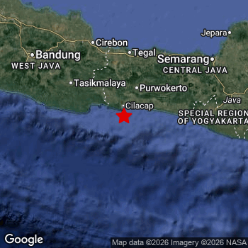 Map of area around epicenter. Click to open in Google Maps. |
| Magnitude: | MAG 5.2 Detected by 95 stations. Maximum Error Range ±0.059 . |
| Depth: | 79 km (49 mi) An intermediate depth. |
| Tsunami Risk: | Low tsunami risk Earthquakes under MAG-6.5 do not usually cause tsunami's. Always stay cautious - More info here. |
Nearby towns and cities
This earthquake may have been felt in Indonesia . The closest significant population center near the earthquake is Kroya in Central Java, Indonesia. Kroya is located 50 kilometer (31 mi) southwest of the epicenter.
Major cities near this earthquake: Bandung is located 201 km to the northwest. Semarang is located 190 km to the north-east. Yogyakarta is located 147 km to the east.
An overview of nearby towns and cities is available in the overview below.
Overview of nearby places
| Distance | Place |
|---|---|
| 50 km (31 mi) NE from epicenter |
Kroya Central Java, Indonesia. |
| 57 km (35 mi) N from epicenter |
Wangon Central Java, Indonesia. |
| 64 km (40 mi) NE from epicenter |
Banyumas Central Java, Indonesia. |
| 67 km (42 mi) NW from epicenter |
Sidareja Central Java, Indonesia. |
| 69 km (43 mi) N from epicenter |
Sokaraja Central Java, Indonesia. |
| 70 km (43 mi) NE from epicenter |
Gombong Central Java, Indonesia. |
| 71 km (44 mi) N from epicenter |
Purwokerto Central Java, Indonesia. |
| 80 km (50 mi) NE from epicenter |
Purbalingga Central Java, Indonesia. |
| 84 km (52 mi) N from epicenter |
Baturaden Central Java, Indonesia. |
| 88 km (55 mi) N from epicenter |
Majenang Central Java, Indonesia. |
| 110 km (68 mi) NW from epicenter |
Ciamis West Java, Indonesia. |
| 117 km (73 mi) N from epicenter |
Slawi Central Java, Indonesia. |
| 118 km (73 mi) NW from epicenter |
Kawalu West Java, Indonesia. |
| 120 km (75 mi) NW from epicenter |
Tasikmalaya West Java, Indonesia. |
| 120 km (75 mi) NE from epicenter |
Wonosobo Central Java, Indonesia. |
| 122 km (76 mi) N from epicenter |
Adiwerna Central Java, Indonesia. |
| 123 km (76 mi) N from epicenter |
Tarub Central Java, Indonesia. |
| 126 km (78 mi) N from epicenter |
Dukuhturi Central Java, Indonesia. |
| 130 km (81 mi) N from epicenter |
Tegal Central Java, Indonesia. |
| 132 km (82 mi) N from epicenter |
Pemalang Central Java, Indonesia. |
| 133 km (83 mi) NW from epicenter |
Kuningan West Java, Indonesia. |
| 135 km (84 mi) NE from epicenter |
Kedungwuni Central Java, Indonesia. |
| 139 km (86 mi) N from epicenter |
Karangsembung West Java, Indonesia. |
| 142 km (88 mi) NE from epicenter |
Mertoyudan Central Java, Indonesia. |
| 143 km (89 mi) E from epicenter |
Kasihan Yogyakarta, Indonesia. |
| 143 km (89 mi) NE from epicenter |
Magelang Central Java, Indonesia. |
| 143 km (89 mi) E from epicenter |
Gamping Lor Yogyakarta, Indonesia. |
| 144 km (89 mi) N from epicenter |
Astanajapura West Java, Indonesia. |
| 145 km (90 mi) E from epicenter |
Sewon Yogyakarta, Indonesia. |
| 145 km (90 mi) NE from epicenter |
Pekalongan Central Java, Indonesia. |
| 147 km (91 mi) E from epicenter |
Yogyakarta Yogyakarta, Indonesia. |
| 155 km (96 mi) NW from epicenter |
Sumber West Java, Indonesia. |
| 155 km (96 mi) E from epicenter |
Depok Yogyakarta, Indonesia. |
| 157 km (98 mi) N from epicenter |
Cirebon West Java, Indonesia. |
| 159 km (99 mi) NW from epicenter |
Weru West Java, Indonesia. |
| 161 km (100 mi) NW from epicenter |
Majalengka West Java, Indonesia. |
| 161 km (100 mi) NW from epicenter |
Plumbon West Java, Indonesia. |
| 162 km (101 mi) NW from epicenter |
Klangenan West Java, Indonesia. |
| 163 km (101 mi) NW from epicenter |
Palimanan West Java, Indonesia. |
| 170 km (106 mi) NW from epicenter |
Arjawinangun West Java, Indonesia. |
| 175 km (109 mi) E from epicenter |
Klaten Central Java, Indonesia. |
| 175 km (109 mi) NW from epicenter |
Paseh West Java, Indonesia. |
| 177 km (110 mi) NE from epicenter |
Salatiga Central Java, Indonesia. |
| 180 km (112 mi) NE from epicenter |
Ungaran Central Java, Indonesia. |
| 181 km (112 mi) NW from epicenter |
Sumedang West Java, Indonesia. |
| 190 km (118 mi) NE from epicenter |
Semarang Central Java, Indonesia. |
| 195 km (121 mi) NW from epicenter |
Banjaran West Java, Indonesia. |
| 201 km (125 mi) NW from epicenter |
Bandung West Java, Indonesia. |
| 203 km (126 mi) E from epicenter |
Surakarta Central Java, Indonesia. |
| 210 km (130 mi) NW from epicenter |
Cimahi West Java, Indonesia. |
| 276 km (171 mi) E from epicenter |
Madiun East Java, Indonesia. |
| 296 km (184 mi) NW from epicenter |
Bogor West Java, Indonesia. |
Shaking reported by 5 people
People that feel an earthquake may report their experience to the US Geographic Survey. Currently, 5 people have reported shaking in 5 places, all within Indonesia.We keep updating this article as more ground reports become available. You may report that you felt this earthquake here.
Places with most reports:
- Kadungora, Jawa Barat, Indonesia: 1 person.
- Banyumas, Jawa Tengah, Indonesia: 1 person.
- Purwokerto, Jawa Tengah, Indonesia: 1 person.
- Karawang, Jawa Barat, Indonesia: 1 person.
- Kebumen, Jawa Tengah, Indonesia: 1 person.
This is likely an aftershock
Approximately 9 sec before this earthquake hit, a larger 5.2 magnitude earthquake struck 17 km (11 mi) east of this one. For that reason, we classify the Mag. 5.2 earthquake as an aftershock.
Overview of foreshocks and aftershocks
| Classification | Magnitude | When | Where |
|---|---|---|---|
| Foreshock | M 4.0 |
3 days earlier Sep 1, 2026 19:54 (Jakarta Time) | 44 km (27 mi) S from Main Shock. |
| Main Shock | M 5.2 |
Sep 4, 2026 12:04 (Jakarta Time) | - |
| Aftershock This Earthquake |
M 5.2 |
9 sec later Sep 4, 2026 12:05 (Jakarta Time) | 17 km (11 mi) W from Main Shock. |
More earthquakes coming?
Aftershocks are usually at least 1 order of magnitude less strong than main shocks. The more time passes, the smaller the chance and likely strength of any potential aftershocks.
The chance that a significant earthquake like this one is followed by an even larger earthquake is not so large. On average, scientists estimate a 94% chance that a major earthquake will not be followed by an even larger one. It is still adviced to be aware of this risk
Read: How to Stay Safe during an Earthquake (cdc.gov).Earthquakes like this happen often in the region
Earthquakes of this strength are very common in the region. In total, 19 earthquakes with a magnitude of 5.2 or higher have been registered within 300km (186 mi) of this epicenter in the past 10 years. This comes down to an average of once every 6 months.
Low tsunami risk
Based on early data it appears this earthquake was not strong enough (lower than MAG-6.5) to be likely to cause destructive tsunami's. However this earthquake appeared to have hit at a shallow depth under sea, so stay cautious and monitor advice from local authorities.
Tsunami Risk Factors
| Factor | Under Sea? | MAG-6.5 or stronger? | Shallow depth? |
|---|---|---|---|
| Explanation | Almost all tsunami's are caused by earthquakes with their epicenter under sea or very near the sea. However stay cautious in coastal areas as earthquakes on land may cause landslides into sea, potentially still causing a local tsunami. | Under MAG 6.5: Very unlikely to cause a tsunami. MAG 6.5 to 7.5: Destructive tsunami's do occur, but are uncommon. Likely to observe small sea level changes. MAG 7.6+: Earthquakes with these magnitudes might produce destructive tsunami's. |
Most destructive tsunami's are caused by shallow earthquakes with a depth between 0 and 100km under the surface of the earth. Deeper tsunami's are unlikely to displace to ocean floor. |
| This Earthquake | This earthquake appears to have struck under the sea. | Not this earthquake. This earthquake had a magnitude of 5.2. Earthquakes of this strength are unlikely to trigger a tsunami. |
This earthquake occurred at a depth of of 79 km (49 mi). Earthquakes this shallow could trigger a tsunami. |
Sources
Last updated 30/09/26 08:48 (). This article contains currently available information about the earthquake and is automatically composed. We continue to update this article up to a few days after the earthquake occurred.
- European-Mediterranean Seismological Centre (EMSC): Earthquake 20260904_0000056
- Geonames.org: World Cities Database
- Google Maps: Static API
- Earthquakelist.org: Historic Earthquakes Database
Share this article:
