
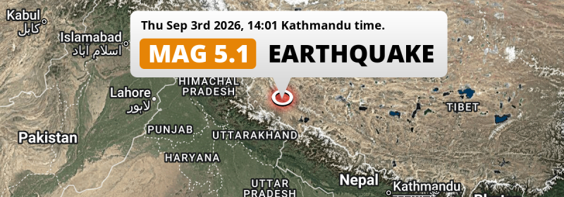
A shallow and significant MAG-5.1 earthquake struck under land China in the afternoon of Thursday September 3rd, 2026. Other countries near the epicenter include Nepal and India.
Felt the earthquake? Share this article: 


Earthquake Summary
The earthquake struck on land in China, 251 kilometer (156 mi) north-east of Dehra Dūn in Uttarakhand. The center of this earthquake had a very shallow depth of 10 km. Shallow earthquakes usually have a larger impact than earthquakes deep in the earth.
| Date and Time: | Sep 3, 2026 02:01PM (Kathmandu Time) - Sep 3, 2026 08:16 Universal Time. |
|---|---|
| Location: | 251 km NE of Dehra Dūn, Uttarakhand, India. Coordinates 31°23'36"N 80°20'55"E. |
| Map: | 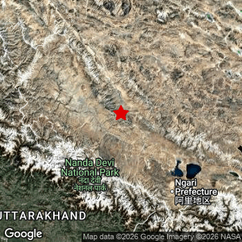 Map of area around epicenter. Click to open in Google Maps. |
| Magnitude: | MAG 5.1 Detected by 162 stations. Maximum Error Range ±0.045 . |
| Depth: | 10 km (6 mi) A very shallow depth. |
| Tsunami Risk: | Tsunami very unlikely While this was a shallow earthquake, it appears to have occurred under land with a magnitude not strong enough to cause tsunami's. Always stay cautious - More info here. |
Nearby towns and cities
Nepal and India are both located within 300km distance of the epicenter of the earthquake.
The closest significant population center near the earthquake is Dārchulā in Sudurpashchim Pradesh, Nepal. Dārchulā is located 175 kilometer (109 mi) north of the epicenter.
Multiple major population centers exist within 300km of the earthquake that struck today. Dehra Dūn is located 251 km to the southwest. Haridwar is located 264 km to the southwest. Haldwani is located 254 km to the south.
A complete list of nearby places is included below.
Overview of nearby places
| Distance | Place |
|---|---|
| 175 km (109 mi) S from epicenter |
Dārchulā Sudurpashchim Pradesh, Nepal. |
| 196 km (122 mi) SW from epicenter |
Uttarkāshi Uttarakhand, India. |
| 198 km (123 mi) SW from epicenter |
Srīnagar Uttarakhand, India. |
| 202 km (126 mi) S from epicenter |
Pithorāgarh Uttarakhand, India. |
| 204 km (127 mi) SW from epicenter |
Pauri Uttarakhand, India. |
| 210 km (130 mi) SW from epicenter |
Tehri Uttarakhand, India. |
| 210 km (130 mi) S from epicenter |
Almora Uttarakhand, India. |
| 214 km (133 mi) SW from epicenter |
Rānikhet Uttarakhand, India. |
| 234 km (145 mi) S from epicenter |
Dadeldhurā Sudurpashchim Pradesh, Nepal. |
| 238 km (148 mi) S from epicenter |
Naini Tāl Uttarakhand, India. |
| 241 km (150 mi) SW from epicenter |
Mussoorie Uttarakhand, India. |
| 243 km (151 mi) SW from epicenter |
Rishīkesh Uttarakhand, India. |
| 244 km (152 mi) S from epicenter |
Dipayal Sudurpashchim Pradesh, Nepal. |
| 247 km (153 mi) SW from epicenter |
Rāipur Uttarakhand, India. |
| 251 km (156 mi) SW from epicenter |
Dehra Dūn Uttarakhand, India. |
| 251 km (156 mi) SW from epicenter |
Rāmnagar Uttarakhand, India. |
| 253 km (157 mi) SW from epicenter |
Kotdwāra Uttarakhand, India. |
| 254 km (158 mi) S from epicenter |
Haldwani Uttarakhand, India. |
| 256 km (159 mi) SW from epicenter |
Clement Town Uttarakhand, India. |
| 259 km (161 mi) S from epicenter |
Tanakpur Uttarakhand, India. |
| 264 km (164 mi) SW from epicenter |
Haridwar Uttarakhand, India. |
| 271 km (168 mi) S from epicenter |
Mahendranagar Sudurpashchim Pradesh, Nepal. |
| 274 km (170 mi) SW from epicenter |
Afzalgarh Uttar Pradesh, India. |
| 276 km (171 mi) SW from epicenter |
Najībābād Uttar Pradesh, India. |
| 276 km (171 mi) SW from epicenter |
Bāzpur Uttarakhand, India. |
| 277 km (172 mi) S from epicenter |
Khatīma Uttarakhand, India. |
| 277 km (172 mi) SW from epicenter |
Kashipur Uttarakhand, India. |
| 277 km (172 mi) SW from epicenter |
Jaspur Uttarakhand, India. |
| 281 km (175 mi) SW from epicenter |
Pāonta Sāhib Himachal Pradesh, India. |
| 281 km (175 mi) S from epicenter |
Sitārganj Uttarakhand, India. |
| 283 km (176 mi) SW from epicenter |
Thakurdwara Uttar Pradesh, India. |
| 284 km (176 mi) SW from epicenter |
Nagīna Uttar Pradesh, India. |
| 286 km (178 mi) SW from epicenter |
Laksar Uttarakhand, India. |
| 286 km (178 mi) SW from epicenter |
Sherkot Uttar Pradesh, India. |
| 287 km (178 mi) S from epicenter |
Kichha Uttarakhand, India. |
| 290 km (180 mi) SW from epicenter |
Roorkee Uttarakhand, India. |
| 291 km (181 mi) SW from epicenter |
Suār Uttar Pradesh, India. |
| 291 km (181 mi) SW from epicenter |
Dhāmpur Uttar Pradesh, India. |
| 294 km (183 mi) SW from epicenter |
Kīratpur Uttar Pradesh, India. |
| 294 km (183 mi) SW from epicenter |
Behat Uttar Pradesh, India. |
| 296 km (184 mi) SW from epicenter |
Seohāra Uttar Pradesh, India. |
| 296 km (184 mi) SW from epicenter |
Manglaur Uttarakhand, India. |
| 297 km (185 mi) S from epicenter |
Bīlāspur Uttar Pradesh, India. |
| 297 km (185 mi) SW from epicenter |
Nihtaur Uttar Pradesh, India. |
Aftershocks detected
Since this main shock, 1 smaller aftershock was detected. Just 2 hrs after this main shock, an earthquake measuring MAG-3.4 was detected 9 km (5 mi) north of this earthquake.
Overview of foreshocks and aftershocks
| Classification | Magnitude | When | Where |
|---|---|---|---|
| Main Shock This Earthquake |
M 5.1 |
Sep 3, 2026 14:01 (Kathmandu Time) | - |
| Aftershock | M 3.4 |
2 hrs later Sep 3, 2026 15:57 (Kathmandu Time) | 9 km (5 mi) N from Main Shock. |
More earthquakes coming?
Earthquakes can create aftershocks. These are generally at least 1 magnitude lower than any main shock, and as time passes the chance and strength of aftershocks decreases.
The chance that a significant earthquake like this one is followed by an even larger earthquake is not so large. On average, scientists estimate a 94% chance that a major earthquake will not be followed by an even larger one. It is still adviced to be aware of this risk
Read: How to Stay Safe during an Earthquake (cdc.gov).Earthquakes like this are common in the region
Earthquakes of this strength occur quite regularly in the region. This is the strongest earthquake to hit since April 13th, 2024, when a 5.5 magnitude earthquake hit 279 km (173 mi) further north-east. An even stronger magnitude 5.7 earthquake struck on October 3rd, 2023.
In total, 6 earthquakes with a magnitude of 5.1 or higher have been registered within 300km (186 mi) of this epicenter in the past 10 years. This comes down to an average of once every 2 years.
Tsunami very unlikely
While MAG-6.5+ earthquakes may cause tsunami's, it appears that the epicenter of this earthquake hit under land. In addition, the reported depth is deeper than 100km, making the risk of a tsunami even less likely. However always stay cautious and monitor advice from local authorities.
Tsunami Risk Factors
| Factor | Under Sea? | MAG-6.5 or stronger? | Shallow depth? |
|---|---|---|---|
| Explanation | Almost all tsunami's are caused by earthquakes with their epicenter under sea or very near the sea. However stay cautious in coastal areas as earthquakes on land may cause landslides into sea, potentially still causing a local tsunami. | Under MAG 6.5: Very unlikely to cause a tsunami. MAG 6.5 to 7.5: Destructive tsunami's do occur, but are uncommon. Likely to observe small sea level changes. MAG 7.6+: Earthquakes with these magnitudes might produce destructive tsunami's. |
Most destructive tsunami's are caused by shallow earthquakes with a depth between 0 and 100km under the surface of the earth. Deeper tsunami's are unlikely to displace to ocean floor. |
| This Earthquake | Not this earthquake. This earthquake appears to have struck on land far from any coast. |
Not this earthquake. This earthquake had a magnitude of 5.1. Earthquakes of this strength are unlikely to trigger a tsunami. |
This earthquake occurred at a depth of of 10 km (6 mi). Earthquakes this shallow could trigger a tsunami. |
Sources
Last updated 27/09/26 02:18 (). This article contains currently available information about the earthquake and is automatically composed. We continue to update this article up to a few days after the earthquake occurred.
- US Geographic Society (USGS): Earthquake us7000tdv4
- European-Mediterranean Seismological Centre (EMSC): Earthquake 20260903_0000126
- Geonames.org: World Cities Database
- Google Maps: Static API
- Earthquakelist.org: Historic Earthquakes Database
Share this article:
