
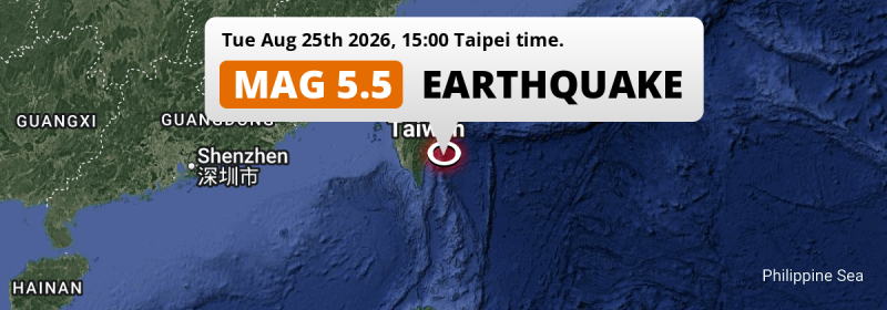
A shallow and significant M5.5 earthquake struck in the Philippine Sea 136 kilometer from Kaohsiung, Taiwan in the afternoon of Tuesday August 25th, 2026. Roughly 360 thousand people may have felt this earthquake.
Felt the earthquake? Share this article: 


Earthquake Summary
This earthquake hit under water in the Philippine Sea, 53 kilometers (33 mi) off the coast of Taiwan, 136 kilometer east of Kaohsiung. The center of this earthquake had a very shallow depth of 10 km. Shallow earthquakes usually have a larger impact than earthquakes deep in the earth.
| Date and Time: | Aug 25, 2026 15:00 (Taipei Time) - Aug 25, 2026 07:00 Universal Time. |
|---|---|
| Location: | 136 km east of Kaohsiung, Taiwan. Coordinates 22°36'37"N 121°38'28"E. |
| Map: | 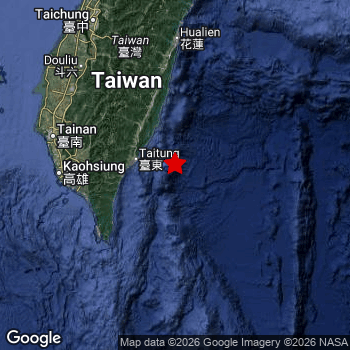 Map of area around epicenter. Click to open in Google Maps. |
| Magnitude: | MAG 5.5 Detected by 22 stations. Maximum Error Range ±0.066 . |
| Depth: | 10 km (6 mi) A very shallow depth. |
| Max. Intensity: | V
Moderate On the Modified Mercalli Scale. |
| Tsunami Risk: | Low tsunami risk Earthquakes under MAG-6.5 do not usually cause tsunami's. Always stay cautious - More info here. |
Minimal impact predicted
Based on scientific estimates by the US Geographic Survey (USGS), the risk of high fatalities for this earthquake is classified at level GREEN (low). They expect an 90% likelyhood of between 0 and 1 fatalities.
The USGS classifies the economic impact of this earthquake at level GREEN (low). They expect an 90% likelyhood of between 0 and 1 million US Dollars in economic damage and impact.
Roughly 360 thousand people exposed to shaking
An estimated 360 thousand have been exposed to shaking (An MMI or Modified Mercalli Intensity level II or higher) as a result of this earthquake according scientific estimates published by the USGS.
An estimated 2,940 people were exposed to level V. At this level, moderate shaking and very light damage can be expected. The majority of people (roughly 190 thousand) live in an area exposed to level IV, where light shaking and likely no damage is expected. All exposure to shaking was within the borders of Taiwan .
| People | MMI Level | Shaking | Damage |
|---|---|---|---|
| 0 | I |
Not noticable | None |
| 0 | II |
Very weak | None |
| 168,500 | III |
Weak | Probably none |
| 188,700 | IV |
Light | Likely none |
| 2,940 | V |
Moderate | Very light |
| 0 | VI |
Strong | Light |
| 0 | VII |
Very Strong | Moderate |
| 0 | VIII |
Severe | Moderate to heavy |
| 0 | IX |
Violent | Heavy |
| 0 | X |
Extreme | Very heavy |
Nearby towns and cities
This earthquake may have been felt in Taiwan . The closest significant population center near the earthquake is Hengchun in Pingtung County, Taiwan. Hengchun is located 114 kilometer (71 mi) north-east of the epicenter. The intensity of shaking and damage in Hengchun is estimated to be around level III on the Modified Mercalli Intensity scale (weak shaking, probably no damage).
Multiple major population centers exist within 300km of the earthquake that struck today. Taipei is located 271 km to the north (intensity unknown, possibly low). Kaohsiung is located 136 km to the west (intensity unknown, possibly low). Taichung is located 197 km to the northwest (intensity unknown, possibly low).
The table below provides an overview of all places in proximity of today's earthquake. Where available, the estimated intensity on the Modified Mercalli Intensity Scale in each place is included. Places where this information is omitted likely experienced little impact.
Overview of nearby places
| Distance | Place | Intensity (MMI) |
|---|---|---|
| 114 km (71 mi) SW from epicenter |
Hengchun Pingtung County, Taiwan. |
III
Weak |
| 123 km (76 mi) W from epicenter |
Donggang Pingtung County, Taiwan. |
|
| 134 km (83 mi) NW from epicenter |
Yujing Tainan City, Taiwan. |
|
| 136 km (85 mi) W from epicenter |
Kaohsiung Kaohsiung, Taiwan. |
|
| 152 km (94 mi) W from epicenter |
Tainan Tainan City, Taiwan. |
|
| 152 km (94 mi) N from epicenter |
Hualien City Hualien County, Taiwan. |
|
| 156 km (97 mi) NW from epicenter |
Lugu Nantou County, Taiwan. |
|
| 166 km (103 mi) NW from epicenter |
Puli Nantou County, Taiwan. |
|
| 166 km (103 mi) NW from epicenter |
Douliu Yunlin County, Taiwan. |
|
| 176 km (109 mi) NW from epicenter |
Nantou Nantou County, Taiwan. |
|
| 179 km (111 mi) NW from epicenter |
Zhongxing New Village Nantou County, Taiwan. |
|
| 185 km (115 mi) NW from epicenter |
Yuanlin Changhua County, Taiwan. |
|
| 197 km (122 mi) NW from epicenter |
Taichung Taichung City, Taiwan. |
|
| 235 km (146 mi) NW from epicenter |
Magong Penghu County , Taiwan. |
|
| 239 km (149 mi) N from epicenter |
Yilan Yilan County, Taiwan. |
|
| 253 km (157 mi) N from epicenter |
Hsinchu Hsinchu County, Taiwan. |
|
| 255 km (158 mi) N from epicenter |
Daxi Taoyuan City , Taiwan. |
|
| 267 km (166 mi) N from epicenter |
Taoyuan City Taoyuan City , Taiwan. |
|
| 268 km (167 mi) N from epicenter |
Banqiao New Taipei City, Taiwan. |
|
| 271 km (168 mi) N from epicenter |
Taipei Taipei City, Taiwan. |
|
| 280 km (174 mi) N from epicenter |
Keelung Keelung, Taiwan. |
Earthquake Intensity Map
The intensity in shaking and damage by this earthquake is illustrated through the map below. The highest intensity measured for this earthquake is V.

Shaking reported by 14 people
People that feel an earthquake may report their experience to the US Geographic Survey. Currently, 14 people have reported shaking in 9 places, all within Taiwan.We keep updating this article as more ground reports become available. You may report that you felt this earthquake here.
Places with most reports:
- Yungho, Taipei Hsien, Taiwan: 3 people.
- Taichung, Taichung Shih, Taiwan: 2 people.
- Sanchung, Taipei Hsien, Taiwan: 2 people.
- Hsinchu, Hsinchu Shih, Taiwan: 2 people.
- Taitung, Taitung, Taiwan: 1 person.
- Fengshan, Kaohsiung Hsien, Taiwan: 1 person.
- Tainan, Tainan Shih, Taiwan: 1 person.
- Chiayi, Chiayi Shih, Taiwan: 1 person.
- Shulin, Taipei Hsien, Taiwan: 1 person.
Aftershocks detected
Since this main shock, 1 smaller aftershock was detected. At a distance of 24 km (15 mi) northwest of this earthquake, an aftershock struck 2 days later. It measured a magnitude of 4.6
Overview of foreshocks and aftershocks
| Classification | Magnitude | When | Where |
|---|---|---|---|
| Main Shock This Earthquake |
M 5.5 |
Aug 25, 2026 15:00 (Taipei Time) | - |
| Aftershock | M 4.6 |
2 days later Aug 27, 2026 05:47 (Taipei Time) | 24 km (15 mi) NW from Main Shock. |
More earthquakes coming?
The risk of aftershocks decreases rapidly over time. Usually, aftershocks are at least one order of magnitude lower than a main shock.
In only six percent of cases, significant earthquakes are followed by a larger main shock, making the current earthquake a foreshock. While the chance of this happening is not so large, it is adviced to maintain cautiousness in the hours and days following a major earthquake.
Read: How to Stay Safe during an Earthquake (cdc.gov).Earthquakes like this happen often in the region
Earthquakes of this strength are very common in the region. This is the strongest earthquake to hit since May 1st, 2026, when a 5.8 magnitude earthquake hit 255 km (158 mi) further north. An even stronger magnitude 7.4 earthquake struck on April 2nd, 2024.
In total, 62 earthquakes with a magnitude of 5.5 or higher have been registered within 300km (186 mi) of this epicenter in the past 10 years. This comes down to an average of once every 2 months.
Low tsunami risk
Based on early data it appears this earthquake was not strong enough (lower than MAG-6.5) to be likely to cause destructive tsunami's. However this earthquake appeared to have hit at a shallow depth under sea, so stay cautious and monitor advice from local authorities.
Tsunami Risk Factors
| Factor | Under Sea? | MAG-6.5 or stronger? | Shallow depth? |
|---|---|---|---|
| Explanation | Almost all tsunami's are caused by earthquakes with their epicenter under sea or very near the sea. However stay cautious in coastal areas as earthquakes on land may cause landslides into sea, potentially still causing a local tsunami. | Under MAG 6.5: Very unlikely to cause a tsunami. MAG 6.5 to 7.5: Destructive tsunami's do occur, but are uncommon. Likely to observe small sea level changes. MAG 7.6+: Earthquakes with these magnitudes might produce destructive tsunami's. |
Most destructive tsunami's are caused by shallow earthquakes with a depth between 0 and 100km under the surface of the earth. Deeper tsunami's are unlikely to displace to ocean floor. |
| This Earthquake | This earthquake appears to have struck under the sea. | Not this earthquake. This earthquake had a magnitude of 5.5. Earthquakes of this strength are unlikely to trigger a tsunami. |
This earthquake occurred at a depth of of 10 km (6 mi). Earthquakes this shallow could trigger a tsunami. |
Sources
Last updated 19/09/26 00:58 (). This article is automatically generated based on available data. We keep checking multiple sources for additional information. This article gets updated as new details on this earthquake become available.
- US Geographic Society (USGS): Earthquake us6000tnbm
- European-Mediterranean Seismological Centre (EMSC): Earthquake 20260825_0000103
- Geonames.org: World Cities Database
- Google Maps: Static API
- Earthquakelist.org: Historic Earthquakes Database
Share this article:
