
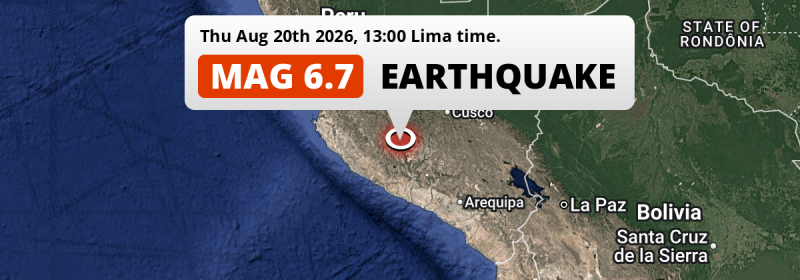
In the early afternoon of Thursday August 20th, 2026, a strong MAG-6.7 earthquake hit under land 176 kilometer from Ayacucho in Peru. Shaking may have been felt by a total of 330 thousand people.
Felt the earthquake? Share this article: 


Earthquake Summary
The earthquake struck on land in Peru, 176 kilometer (109 mi) south of Ayacucho. The center of this earthquake had an intermediate depth of 99 km.
| Date and Time: | Aug 20, 2026 13:00 (Lima Time) - Aug 20, 2026 18:00 Universal Time. |
|---|---|
| Location: | 176 km south of Ayacucho, Peru. Coordinates 14°37'57"S 73°38'25"W. |
| Map: | 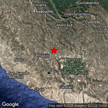 Map of area around epicenter. Click to open in Google Maps. |
| Magnitude: | MAG 6.7 Detected by 62 stations. Maximum Error Range ±0.039 . |
| Depth: | 99 km (62 mi) An intermediate depth. |
| Max. Intensity: | VI
Strong On the Modified Mercalli Scale. |
| Tsunami Risk: | Low Tsunami Risk Mag 6.5+ earthquakes at shallow depth can cause tsunami's, but this epicenter appears to have hit under land, making this less likely. Always stay cautious - More info here. |
Minimal impact predicted
The US Geographic Survey (USGS) describes the impact of this earthquake as follows:
At least 3 people injured; 59 homes and a pedestrian bridge destroyed; 605 homes, 42 buildings and 230 m of roads damaged; landslides and power outages occurred in Ayacucho. Two homes and 1 building damaged in Apurimac and 2 buildings damaged in Cusco.
Based on scientific estimates by the USGS, the risk of high fatalities for this earthquake is classified at level GREEN (low). They expect an 90% likelyhood of between 0 and 1 fatalities.
The USGS classifies the economic impact of this earthquake at level GREEN (low). They expect an 90% likelyhood of between 0 and 1 million US Dollars in economic damage and impact.
Roughly 330 thousand people exposed to shaking
The USGS has published a report estimating the number of people exposed to this earthquake. Acoording to their analysis, roughly 330 thousand have been exposed to shaking at an MMI level of II or higher.
An estimated 890 people were exposed to level VI. At this level, strong shaking and probably light damage can be expected. Intensity level IV was experienced by the majority of people (around 220 thousand). In their region, light shaking and likely no damage can be expected. All exposure to shaking was within the borders of Peru .
| People | MMI Level | Shaking | Damage |
|---|---|---|---|
| 0 | I |
Not noticable | None |
| 0 | II |
Very weak | None |
| 0 | III |
Weak | Probably none |
| 223,900 | IV |
Light | Likely none |
| 103,800 | V |
Moderate | Very light |
| 890 | VI |
Strong | Light |
| 0 | VII |
Very Strong | Moderate |
| 0 | VIII |
Severe | Moderate to heavy |
| 0 | IX |
Violent | Heavy |
| 0 | X |
Extreme | Very heavy |
Nearby towns and cities
This earthquake may have been felt in Peru . The closest significant population center near the earthquake is Andahuaylas in Apurímac, Peru. Andahuaylas is located 112 kilometer (70 mi) south of the epicenter. The intensity of shaking and damage in Andahuaylas is estimated to be around level V on the Modified Mercalli Intensity scale (moderate shaking, very light damage).
Multiple major population centers exist within 300km of the earthquake that struck today. Lima is located 466 km to the northwest (intensity unknown, possibly low). Arequipa is located 299 km to the south-east (intensity unknown, possibly low). Callao is located 473 km to the northwest (intensity unknown, possibly low).
An overview of nearby towns and cities is available in the overview below. If places don't have intensity data available, it likely means the experienced impact in those places was fairly small.
Overview of nearby places
| Distance | Place | Intensity (MMI) |
|---|---|---|
| 112 km (70 mi) N from epicenter |
Andahuaylas Apurímac, Peru. |
V
Moderate |
| 138 km (86 mi) NE from epicenter |
Abancay Apurímac, Peru. |
|
| 141 km (88 mi) W from epicenter |
Nazca Ica, Peru. |
|
| 171 km (106 mi) SW from epicenter |
Minas de Marcona Ica, Peru. |
|
| 176 km (109 mi) N from epicenter |
Ayacucho Ayacucho, Peru. |
|
| 200 km (124 mi) N from epicenter |
Huanta Ayacucho, Peru. |
|
| 217 km (135 mi) NE from epicenter |
Santiago Cusco, Peru. |
|
| 219 km (136 mi) NE from epicenter |
Wanchaq Cusco, Peru. |
|
| 219 km (136 mi) NE from epicenter |
Cusco Cusco, Peru. |
|
| 220 km (137 mi) NE from epicenter |
Santa Ana Cusco, Peru. |
|
| 234 km (145 mi) W from epicenter |
Ica Ica, Peru. |
|
| 241 km (150 mi) E from epicenter |
Yauri Cusco, Peru. |
|
| 243 km (151 mi) SE from epicenter |
Camaná Arequipa, Peru. |
|
| 247 km (153 mi) SE from epicenter |
El Pedregal Arequipa, Peru. |
|
| 251 km (156 mi) NW from epicenter |
Huancavelica Huancavelica, Peru. |
|
| 263 km (163 mi) E from epicenter |
Sicuani Cusco, Peru. |
|
| 290 km (180 mi) SE from epicenter |
Cono Norte Arequipa, Peru. |
|
| 291 km (181 mi) W from epicenter |
San Clemente Ica, Peru. |
|
| 295 km (183 mi) W from epicenter |
Pisco Ica, Peru. |
|
| 298 km (185 mi) SE from epicenter |
Selva Alegre Arequipa, Peru. |
|
| 299 km (186 mi) SE from epicenter |
Arequipa Arequipa, Peru. |
|
| 301 km (187 mi) NW from epicenter |
Chincha Alta Ica, Peru. |
|
| 301 km (187 mi) SE from epicenter |
Jacobo Hunter Arequipa, Peru. |
|
| 302 km (188 mi) SE from epicenter |
Ciudad Satelite Arequipa, Peru. |
|
| 318 km (198 mi) SE from epicenter |
Mollendo Arequipa, Peru. |
|
| 329 km (204 mi) E from epicenter |
Ayaviri Puno, Peru. |
|
| 330 km (205 mi) NW from epicenter |
Chilca Junin, Peru. |
|
| 332 km (206 mi) NW from epicenter |
Huancayo Junin, Peru. |
|
| 337 km (209 mi) NW from epicenter |
Nuevo Imperial Lima Region, Peru. |
|
| 341 km (212 mi) NW from epicenter |
Imperial Lima Region, Peru. |
|
| 343 km (213 mi) NW from epicenter |
San Vicente de Cañete Lima Region, Peru. |
|
| 376 km (234 mi) NW from epicenter |
Jauja Junin, Peru. |
|
| 389 km (242 mi) E from epicenter |
Juliaca Puno, Peru. |
|
| 391 km (243 mi) N from epicenter |
Satipo Junin, Peru. |
|
| 391 km (243 mi) NW from epicenter |
Mala Lima Region, Peru. |
|
| 406 km (252 mi) SE from epicenter |
Moquegua Moquegua, Peru. |
|
| 411 km (255 mi) E from epicenter |
Puno Puno, Peru. |
|
| 414 km (257 mi) SE from epicenter |
Ilo Moquegua, Peru. |
|
| 421 km (262 mi) NW from epicenter |
Tarma Junin, Peru. |
|
| 424 km (263 mi) NW from epicenter |
La Oroya Junin, Peru. |
|
| 447 km (278 mi) NW from epicenter |
Chosica Lima Region, Peru. |
|
| 451 km (280 mi) E from epicenter |
La Rinconada Puno, Peru. |
|
| 458 km (285 mi) NW from epicenter |
Santiago de Surco Lima Region, Peru. |
|
| 460 km (286 mi) NW from epicenter |
San Francisco De Borja Lima Region, Peru. |
|
| 461 km (286 mi) NW from epicenter |
Santa Anita - Los Ficus Lima Region, Peru. |
|
| 464 km (288 mi) NW from epicenter |
San Isidro Lima Region, Peru. |
|
| 466 km (290 mi) NW from epicenter |
Jesus Maria Lima Region, Peru. |
|
| 466 km (290 mi) NW from epicenter |
Lima Lima Region, Peru. |
|
| 467 km (290 mi) NW from epicenter |
Breña Lima Region, Peru. |
|
| 471 km (293 mi) NW from epicenter |
Carmen De La Legua Reynoso Callao, Peru. |
|
| 473 km (294 mi) NW from epicenter |
Callao Callao, Peru. |
Earthquake Intensity Map
The maximum intensity (MMI Scale) caused by this earthquake is VI. The map below shows in which areas this earthquake was the most and least impactful. It is based on data from the US Geographic Survey.

Shaking reported by 75 people in 2 countries
People that feel an earthquake may report their experience to the US Geographic Survey. Currently, 75 people have reported shaking in 19 places in 2 countries (Peru, Chile).We keep updating this article as more ground reports become available. You may report that you felt this earthquake here.
Places with most reports:
- Lima, Lima Provincias, Peru: 20 people.
- San Luis, Lima Provincias, Peru: 18 people.
- Cusco, Cusco, Peru: 13 people.
- Arequipa, Arequipa, Peru: 4 people.
- Santa María, Lima Provincias, Peru: 4 people.
- Iquique, Tarapacá, Chile: 2 people.
- Ayacucho, Ayacucho, Peru: 2 people.
- Trujillo, La Libertad, Peru: 1 person.
- Oxapampa, Pasco, Peru: 1 person.
- Los Aquijes, Ica, Peru: 1 person.
Risk of aftershocks?
This earthquake did not have any significant foreshocks nor aftershocks occurring within 100km (62 mi) of its epicenter.
Aftershocks are usually at least 1 order of magnitude less strong than main shocks. The more time passes, the smaller the chance and likely strength of any potential aftershocks.
The chance that a significant earthquake like this one is followed by an even larger earthquake is not so large. On average, scientists estimate a 94% chance that a major earthquake will not be followed by an even larger one. It is still adviced to be aware of this risk
Read: How to Stay Safe during an Earthquake (cdc.gov).This is an unusually powerful earthquake
Earthquakes of this strength are not so common in the region, but it's not the first time. This is the strongest earthquake to hit since June 28th, 2024, when a 7.2 magnitude earthquake hit 159 km (99 mi) further southwest. That was also the heaviest earthquake to hit the region in the past 10 years.
In total, 2 earthquakes with a magnitude of 6.7 or higher have been registered within 300km (186 mi) of this epicenter in the past 10 years. This comes down to an average of once every 5 years.
Low Tsunami Risk
There is a low tsunami risk following this earthquake, as it appears the epicenter was under land far away from the coast. However this was a very strong earthquake at a shallow depth that would have a very high risk at causing tsunami's if it would have occurred under sea. Stay cautious and monitor advice from local authorities.
Tsunami Risk Factors
| Factor | Under Sea? | MAG-6.5 or stronger? | Shallow depth? |
|---|---|---|---|
| Explanation | Almost all tsunami's are caused by earthquakes with their epicenter under sea or very near the sea. However stay cautious in coastal areas as earthquakes on land may cause landslides into sea, potentially still causing a local tsunami. | Under MAG 6.5: Very unlikely to cause a tsunami. MAG 6.5 to 7.5: Destructive tsunami's do occur, but are uncommon. Likely to observe small sea level changes. MAG 7.6+: Earthquakes with these magnitudes might produce destructive tsunami's. |
Most destructive tsunami's are caused by shallow earthquakes with a depth between 0 and 100km under the surface of the earth. Deeper tsunami's are unlikely to displace to ocean floor. |
| This Earthquake | Not this earthquake. This earthquake appears to have struck on land far from any coast. |
This earthquake had a magnitude of 6.7. Earthquakes of this strength could trigger a tsunami. | This earthquake occurred at a depth of of 99 km (62 mi). Earthquakes this shallow could trigger a tsunami. |
Sources
Last updated 19/10/26 02:08 (). This article contains currently available information about the earthquake and is automatically composed. We continue to update this article up to a few days after the earthquake occurred.
- US Geographic Society (USGS): Earthquake us6000tm81
- European-Mediterranean Seismological Centre (EMSC): Earthquake 20260820_0000536
- Geonames.org: World Cities Database
- Google Maps: Static API
- Earthquakelist.org: Historic Earthquakes Database
Share this article:
