
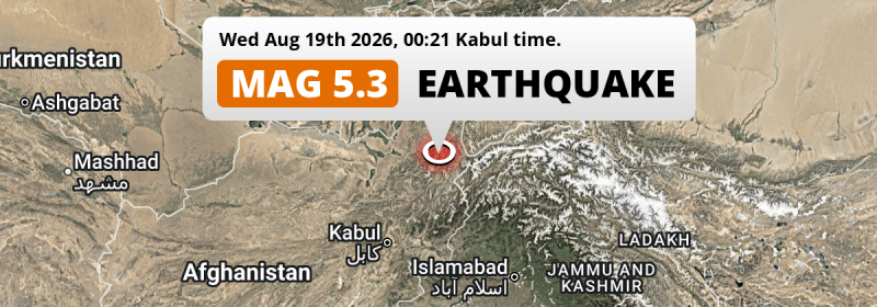
A significant Magnitude 5.2 earthquake struck under land 80 kilometer from Fayzabad in Afghanistan just after midnight of Wednesday August 19th, 2026. Other countries near the epicenter include Tajikistan and Pakistan.
Felt the earthquake? Share this article: 


Earthquake Summary
The earthquake struck on land in Afghanistan, 80 kilometer (50 mi) south of Fayzabad in Badakhshan. The center of this earthquake had an intermediate depth of 215 km.
| Date and Time: | Aug 19, 2026 12:21AM (Kabul Time) - Aug 18, 2026 19:51 Universal Time. |
|---|---|
| Location: | 80 km south of Fayzabad, Badakhshan, Afghanistan. Coordinates 36°24'12"N 70°41'14"E. |
| Map: | 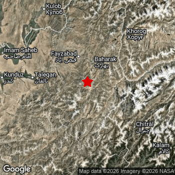 Map of area around epicenter. Click to open in Google Maps. |
| Magnitude: | MAG 5.2 Detected by 24 stations. Maximum Error Range ±0.063 . |
| Depth: | 215 km (134 mi) An intermediate depth. |
| Tsunami Risk: | Tsunami very unlikely Tsunami's are usually caused by MAG-6.5+ earthquakes, less than 100km shallow, and with an epicenter under sea. Neither of this seems to be the case. Always stay cautious - More info here. |
Nearby towns and cities
Afghanistan , Tajikistan and Pakistan are all located within 300km distance of the epicenter of the earthquake.
Fayzabad in Badakhshan, Afghanistan is the nearest significant place from the epicenter. The earthquake occurred 80 kilometer (50 mi) south of Fayzabad.
Major cities near this earthquake: Kabul is located 250 km to the southwest. Peshawar is located 278 km to the south. Battagram is located 285 km to the south-east.
The table below provides an overview of all places in proximity of today's earthquake.
Overview of nearby places
| Distance | Place |
|---|---|
| 80 km (50 mi) N from epicenter |
Fayzabad Badakhshan, Afghanistan. |
| 90 km (56 mi) NE from epicenter |
Ishqoshim Gorno-Badakhshan, Tajikistan. |
| 109 km (68 mi) W from epicenter |
Taloqan Takhar, Afghanistan. |
| 111 km (69 mi) NW from epicenter |
Rustāq Takhar, Afghanistan. |
| 132 km (82 mi) NW from epicenter |
Ārt Khwājah Takhar, Afghanistan. |
| 143 km (89 mi) NE from epicenter |
Khorugh Gorno-Badakhshan, Tajikistan. |
| 144 km (89 mi) W from epicenter |
Khanabad Kunduz, Afghanistan. |
| 144 km (89 mi) W from epicenter |
Nahrīn Baghlan, Afghanistan. |
| 160 km (99 mi) NW from epicenter |
Chubek Khatlon, Tajikistan. |
| 161 km (100 mi) SW from epicenter |
Bāzārak Panjshir, Afghanistan. |
| 164 km (102 mi) S from epicenter |
Āsmār Kunar, Afghanistan. |
| 166 km (103 mi) NW from epicenter |
Farkhor Khatlon, Tajikistan. |
| 167 km (104 mi) W from epicenter |
Kunduz Kunduz, Afghanistan. |
| 171 km (106 mi) SE from epicenter |
Upper Dir Khyber Pakhtunkhwa, Pakistan. |
| 174 km (108 mi) SE from epicenter |
Thal Khyber Pakhtunkhwa, Pakistan. |
| 175 km (109 mi) S from epicenter |
Asadābād Kunar, Afghanistan. |
| 180 km (112 mi) W from epicenter |
Baghlān Baghlan, Afghanistan. |
| 181 km (112 mi) NW from epicenter |
Hulbuk Khatlon, Tajikistan. |
| 184 km (114 mi) W from epicenter |
Pul-e Khumrī Baghlan, Afghanistan. |
| 186 km (116 mi) NW from epicenter |
Kŭlob Khatlon, Tajikistan. |
| 193 km (120 mi) NW from epicenter |
Qarāwul Kunduz, Afghanistan. |
| 194 km (121 mi) SW from epicenter |
Jabal os Saraj Parwan, Afghanistan. |
| 197 km (122 mi) S from epicenter |
Mehtar Lām Laghman, Afghanistan. |
| 206 km (128 mi) SW from epicenter |
Charikar Parwan, Afghanistan. |
| 220 km (137 mi) NW from epicenter |
Vakhsh Khatlon, Tajikistan. |
| 221 km (137 mi) S from epicenter |
Jalālābād Nangarhar, Afghanistan. |
| 223 km (139 mi) NW from epicenter |
Kolkhozobod Khatlon, Tajikistan. |
| 223 km (139 mi) NW from epicenter |
Danghara Khatlon, Tajikistan. |
| 230 km (143 mi) SE from epicenter |
Bat Khela Khyber Pakhtunkhwa, Pakistan. |
| 230 km (143 mi) NW from epicenter |
Moskovskiy Khatlon, Tajikistan. |
| 233 km (145 mi) NW from epicenter |
Bokhtar Khatlon, Tajikistan. |
| 236 km (147 mi) SE from epicenter |
Mingora Khyber Pakhtunkhwa, Pakistan. |
| 240 km (149 mi) W from epicenter |
Aībak Samangan, Afghanistan. |
| 250 km (155 mi) SW from epicenter |
Kabul Kabul, Afghanistan. |
| 250 km (155 mi) S from epicenter |
Tangi Khyber Pakhtunkhwa, Pakistan. |
| 252 km (157 mi) NW from epicenter |
Norak Khatlon, Tajikistan. |
| 256 km (159 mi) S from epicenter |
Shabqadar Khyber Pakhtunkhwa, Pakistan. |
| 256 km (159 mi) SW from epicenter |
Paghmān Kabul, Afghanistan. |
| 265 km (165 mi) S from epicenter |
Utmanzai Khyber Pakhtunkhwa, Pakistan. |
| 268 km (167 mi) S from epicenter |
Charsadda Khyber Pakhtunkhwa, Pakistan. |
| 269 km (167 mi) W from epicenter |
Khulm Balkh, Afghanistan. |
| 275 km (171 mi) SE from epicenter |
Mardan Khyber Pakhtunkhwa, Pakistan. |
| 278 km (173 mi) S from epicenter |
Peshawar Khyber Pakhtunkhwa, Pakistan. |
| 281 km (175 mi) NW from epicenter |
Vahdat Republican Subordination, Tajikistan. |
| 283 km (176 mi) NW from epicenter |
Boshkengash Dushanbe, Tajikistan. |
| 285 km (177 mi) S from epicenter |
Pabbi Khyber Pakhtunkhwa, Pakistan. |
| 285 km (177 mi) SE from epicenter |
Battagram Khyber Pakhtunkhwa, Pakistan. |
| 286 km (178 mi) SE from epicenter |
Risalpur Cantonment Khyber Pakhtunkhwa, Pakistan. |
| 289 km (180 mi) SE from epicenter |
Aman Garh Khyber Pakhtunkhwa, Pakistan. |
| 291 km (181 mi) NW from epicenter |
Dushanbe Dushanbe, Tajikistan. |
| 293 km (182 mi) SE from epicenter |
Nowshera Cantonment Khyber Pakhtunkhwa, Pakistan. |
Shaking reported by 1 person
People that feel an earthquake may report their experience to the US Geographic Survey. Currently, 1 person has reported shaking in one place in Pakistan.We keep updating this article as more ground reports become available. You may report that you felt this earthquake here.
Places with most reports:
- Swābi, North-West Frontier, Pakistan: 1 person.
Risk of aftershocks?
We have not yet detected any foreshocks or aftershocks (MAG-2.5 or higher) within 100km (62 mi) of this earthquake.
Earthquakes can create aftershocks. These are generally at least 1 magnitude lower than any main shock, and as time passes the chance and strength of aftershocks decreases.
It's always adviced to be cautious of the risk of a larger shock following any significant earthquake, however this risk is fairly small. There is a roughly 94 percent change that no larger main shock will follow in the days following this earthquake.
Read: How to Stay Safe during an Earthquake (cdc.gov).Earthquakes like this happen often in the region
Earthquakes of this strength are very common in the region. This is the strongest earthquake to hit since July 1st, 2026, when a 5.5 magnitude earthquake hit 27 km (17 mi) further northwest. An even stronger magnitude 6.9 earthquake struck on February 23rd, 2023.
In total, 43 earthquakes with a magnitude of 5.2 or higher have been registered within 300km (186 mi) of this epicenter in the past 10 years. This comes down to an average of once every 3 months.
Tsunami very unlikely
It is very unlikely that this eartquake will cause any tsunami's. The reported magnitude is lower than the MAG-6.5 strength required to cause any earthquakes. In addition, this earthquake was not very shallow and appears to have occurred under land. However always stay cautious and monitor advice from local authorities.
Tsunami Risk Factors
| Factor | Under Sea? | MAG-6.5 or stronger? | Shallow depth? |
|---|---|---|---|
| Explanation | Almost all tsunami's are caused by earthquakes with their epicenter under sea or very near the sea. However stay cautious in coastal areas as earthquakes on land may cause landslides into sea, potentially still causing a local tsunami. | Under MAG 6.5: Very unlikely to cause a tsunami. MAG 6.5 to 7.5: Destructive tsunami's do occur, but are uncommon. Likely to observe small sea level changes. MAG 7.6+: Earthquakes with these magnitudes might produce destructive tsunami's. |
Most destructive tsunami's are caused by shallow earthquakes with a depth between 0 and 100km under the surface of the earth. Deeper tsunami's are unlikely to displace to ocean floor. |
| This Earthquake | Not this earthquake. This earthquake appears to have struck on land far from any coast. |
Not this earthquake. This earthquake had a magnitude of 5.2. Earthquakes of this strength are unlikely to trigger a tsunami. |
Not this earthquake. This earthquake occurred at a depth of 215 km (134 mi). Earthquakes this deep in the earth are unlikely to trigger a tsunami. |
Sources
Last updated 09/09/26 21:58 (). This article is automatically generated based on available data. We keep checking multiple sources for additional information. This article gets updated as new details on this earthquake become available.
- US Geographic Society (USGS): Earthquake us6000tlqq
- European-Mediterranean Seismological Centre (EMSC): Earthquake 20260818_0000687
- Geonames.org: World Cities Database
- Google Maps: Static API
- Earthquakelist.org: Historic Earthquakes Database
Share this article:
