
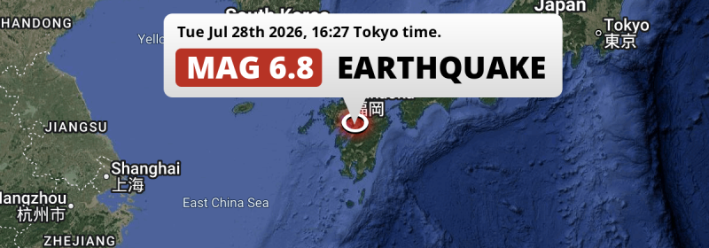
Under land 23 kilometer from Kumamoto in Japan, a DESTRUCTIVE and strong Magnitude 6.8 earthquake occurred in the late afternoon of Tuesday July 28th, 2026. The earthquake struck near a very densely populated region. Mag 6.5+ earthquakes at shallow depth under sea have the potential to cause tsunami's.
Felt the earthquake? Share this article: 


Earthquake Summary
The earthquake struck on land in Japan, 23 kilometer (14 mi) south of Kumamoto. The center of this earthquake had a very shallow depth of 8 km. Shallow earthquakes usually have a larger impact than earthquakes deep in the earth.
| Date and Time: | Jul 28, 2026 16:27 (Tokyo Time) - Jul 28, 2026 07:27 Universal Time. |
|---|---|
| Location: | 23 km south of Kumamoto, Japan. Coordinates 32°36'15"N 130°37'37"E. |
| Map: | 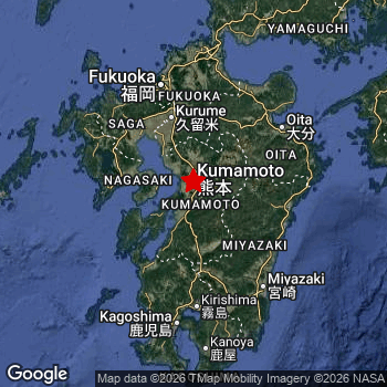 Map of area around epicenter. Click to open in Google Maps. |
| Magnitude: | MAG 6.8 Detected by 59 stations. Maximum Error Range ±0.046 . |
| Depth: | 8 km (5 mi) A very shallow depth. |
| Max. Intensity: | X
Extreme On the Modified Mercalli Scale. |
| Tsunami Risk: | Potential Tsunami Risk Mag 6.5+ earthquakes at shallow depth under sea have the potential to cause tsunami's. Always stay cautious - More info here. |
Potential Tsunami Risk
There is a potential tsunami risk in the aftermath of this earthquake, immediately evacuate to higher grounds away from coastal areas and monitor advice from local authorities. This earthquake checks all the likely tsunami risk factors: under sea, at a magnitude of MAG-6.5+ and at a shallow depth.
Tsunami Risk Factors
| Factor | Under Sea? | MAG-6.5 or stronger? | Shallow depth? |
|---|---|---|---|
| Explanation | Almost all tsunami's are caused by earthquakes with their epicenter under sea or very near the sea. However stay cautious in coastal areas as earthquakes on land may cause landslides into sea, potentially still causing a local tsunami. | Under MAG 6.5: Very unlikely to cause a tsunami. MAG 6.5 to 7.5: Destructive tsunami's do occur, but are uncommon. Likely to observe small sea level changes. MAG 7.6+: Earthquakes with these magnitudes might produce destructive tsunami's. |
Most destructive tsunami's are caused by shallow earthquakes with a depth between 0 and 100km under the surface of the earth. Deeper tsunami's are unlikely to displace to ocean floor. |
| This Earthquake | This earthquake appears to have struck under the sea. | This earthquake had a magnitude of 6.8. Earthquakes of this strength could trigger a tsunami. | This earthquake occurred at a depth of of 8 km (5 mi). Earthquakes this shallow could trigger a tsunami. |
Significant impact predicted
The US Geographic Survey (USGS) describes the impact of this earthquake as follows:
Five persons killed at Hikawa, 7 at Kashima, 1 at Kosa, 3 at Uki and 20 at Yatsushiro. Two persons injured in Fukuoka, 1 in Kagoshima, 166 in Kumamoto and 1 in Oita. At least 1744 homes destroyed and 13544 damaged, at least 4600 buildings damaged in the Fukuoka-Kagoshima-Kumamoto-Saga-Oita, area. Power and water outages occurred in the Kumamoto-Nagasaki area. Surface ruptures, ground deformation and liquefaction reported in Kumamoto. Landslides reported in the Shimabara area, Nagasaki.
Based on scientific estimates by the USGS, the risk of high fatalities for this earthquake is classified at level ORANGE (orange). They expect an 44% likelyhood of between 100 and 1,000 fatalities, and a 92% chance that the number of fatalities falls between 10 and 10,000.
The USGS classifies the economic impact of this earthquake at level RED (high). They expect an 36% likelyhood of between 10,000 and 100,000 million US Dollars in economic damage and impact, and a 98% chance that the economic impact of this earthquake falls between 100 and 10,000,000 million USD.
Roughly 17 million people exposed to shaking
An estimated 17 million have been exposed to shaking (An MMI or Modified Mercalli Intensity level II or higher) as a result of this earthquake according scientific estimates published by the USGS.
Violent shaking and likely heavy damage may have been experienced by an estimated 233,400 people. At IX, it is the highest MMI level this earthquake has caused. Intensity level IV was experienced by the majority of people (around 10 million). In their region, light shaking and likely no damage can be expected.
People in 2 countries have been exposed to shaking. In Japan , around 17 million people, with impact levels up to IX (violent shaking, likely heavy damage). Shaking was experienced by inhabitants of South Korea too.
| People | MMI Level | Shaking | Damage |
|---|---|---|---|
| 0 | I |
Not noticable | None |
| 0 | II |
Very weak | None |
| 2,182,000 | III |
Weak | Probably none |
| 9,685,000 | IV |
Light | Likely none |
| 3,429,000 | V |
Moderate | Very light |
| 631,800 | VI |
Strong | Light |
| 374,900 | VII |
Very Strong | Moderate |
| 623,100 | VIII |
Severe | Moderate to heavy |
| 233,400 | IX |
Violent | Heavy |
| 0 | X |
Extreme | Very heavy |
Nearby towns and cities
This earthquake may have been felt in Japan . Located 6 kilometer (4 mi) southwest of the epicenter of this earthquake, Matsubase (Kumamoto, Japan) is the nearest significant population center. Matsubase experienced an earthquake intensity (MMI Scale) of roughly VIII. That level implies severe shaking and likely moderate to heavy damage.
Major cities near this earthquake: Kumamoto is located 23 km to the north and experienced an intensity of VIII (severe shaking, likely moderate to heavy damage). Fukuoka is located 112 km to the north and experienced an intensity of IV (light shaking, likely no damage). Busan is located 314 km to the northwest (intensity unknown, possibly low).
A complete list of nearby places is included below. Estimated intensity data (MMI) sourced from a shake-map published by the US Geographic Survey is shown where available (cities without data probably experienced little impact).
Overview of nearby places
| Distance | Place | Intensity (MMI) |
|---|---|---|
| 6 km (4 mi) NE from epicenter |
Matsubase Kumamoto, Japan. |
VIII
Severe |
| 10 km (6 mi) N from epicenter |
Uto Kumamoto, Japan. |
VIII
Severe |
| 11 km (7 mi) S from epicenter |
Honmachi Kumamoto, Japan. |
IX
Violent |
| 22 km (14 mi) NE from epicenter |
Mifune Kumamoto, Japan. |
VIII
Severe |
| 23 km (14 mi) N from epicenter |
Kumamoto Kumamoto, Japan. |
VIII
Severe |
| 31 km (19 mi) NW from epicenter |
Shimabara Nagasaki, Japan. |
V
Moderate |
| 33 km (21 mi) N from epicenter |
Uekimachi-mōno Kumamoto, Japan. |
VI
Strong |
| 38 km (24 mi) N from epicenter |
Tamana Kumamoto, Japan. |
V
Moderate |
| 38 km (24 mi) NE from epicenter |
Ōzu Kumamoto, Japan. |
VII
Very Strong |
| 40 km (25 mi) NW from epicenter |
Nagasu Kumamoto, Japan. |
V
Moderate |
| 45 km (28 mi) S from epicenter |
Hitoyoshi Kumamoto, Japan. |
VI
Strong |
| 46 km (29 mi) N from epicenter |
Yamaga Kumamoto, Japan. |
VI
Strong |
| 46 km (29 mi) N from epicenter |
Kikuchi Kumamoto, Japan. |
VI
Strong |
| 46 km (29 mi) W from epicenter |
Hondomachi-hondo Kumamoto, Japan. |
VI
Strong |
| 48 km (30 mi) SW from epicenter |
Minamata Kumamoto, Japan. |
VII
Very Strong |
| 50 km (31 mi) N from epicenter |
Ōmuta Fukuoka, Japan. |
V
Moderate |
| 56 km (35 mi) NE from epicenter |
Aso Kumamoto, Japan. |
VI
Strong |
| 60 km (37 mi) S from epicenter |
Ōkuchi-shinohara Kagoshima, Japan. |
VI
Strong |
| 61 km (38 mi) NW from epicenter |
Isahaya Nagasaki, Japan. |
V
Moderate |
| 62 km (39 mi) N from epicenter |
Setakamachi-takayanagi Fukuoka, Japan. |
V
Moderate |
| 63 km (39 mi) S from epicenter |
Izumi Kagoshima, Japan. |
VI
Strong |
| 66 km (41 mi) N from epicenter |
Yanagawa Fukuoka, Japan. |
V
Moderate |
| 71 km (44 mi) W from epicenter |
Nagasaki Nagasaki, Japan. |
IV
Light |
| 71 km (44 mi) N from epicenter |
Ōkawa Fukuoka, Japan. |
V
Moderate |
| 72 km (45 mi) NW from epicenter |
Ōmura Nagasaki, Japan. |
IV
Light |
| 72 km (45 mi) SW from epicenter |
Ushibukamachi Kumamoto, Japan. |
V
Moderate |
| 73 km (45 mi) W from epicenter |
Obita Nagasaki, Japan. |
IV
Light |
| 75 km (47 mi) NW from epicenter |
Kashima Saga, Japan. |
V
Moderate |
| 76 km (47 mi) NW from epicenter |
Saga Saga, Japan. |
V
Moderate |
| 77 km (48 mi) SW from epicenter |
Akune Kagoshima, Japan. |
VI
Strong |
| 77 km (48 mi) W from epicenter |
Togitsu Nagasaki, Japan. |
IV
Light |
| 77 km (48 mi) SE from epicenter |
Kobayashi Miyazaki, Japan. |
V
Moderate |
| 80 km (50 mi) N from epicenter |
Kurume Fukuoka, Japan. |
V
Moderate |
| 82 km (51 mi) N from epicenter |
Kanzakimachi-kanzaki Saga, Japan. |
IV
Light |
| 83 km (52 mi) N from epicenter |
Tanushimarumachi-toyoki Fukuoka, Japan. |
V
Moderate |
| 85 km (53 mi) N from epicenter |
Tosu Saga, Japan. |
V
Moderate |
| 85 km (53 mi) N from epicenter |
Hita Ōita, Japan. |
V
Moderate |
| 86 km (53 mi) NW from epicenter |
Takeo Saga, Japan. |
IV
Light |
| 91 km (57 mi) N from epicenter |
Amagi Fukuoka, Japan. |
V
Moderate |
| 92 km (57 mi) SE from epicenter |
Tsuma Miyazaki, Japan. |
V
Moderate |
| 93 km (58 mi) S from epicenter |
Satsumasendai Kagoshima, Japan. |
VI
Strong |
| 97 km (60 mi) E from epicenter |
Nobeoka Miyazaki, Japan. |
V
Moderate |
| 98 km (61 mi) S from epicenter |
Kokubu-matsuki Kagoshima, Japan. |
V
Moderate |
| 99 km (62 mi) S from epicenter |
Hamanoichi Kagoshima, Japan. |
V
Moderate |
| 100 km (62 mi) N from epicenter |
Chikushino-shi Fukuoka, Japan. |
IV
Light |
| 105 km (65 mi) NW from epicenter |
Sasebo Nagasaki, Japan. |
IV
Light |
| 107 km (66 mi) SE from epicenter |
Miyazaki Miyazaki, Japan. |
V
Moderate |
| 112 km (70 mi) N from epicenter |
Fukuoka Fukuoka, Japan. |
IV
Light |
| 115 km (71 mi) NE from epicenter |
Ōita Ōita, Japan. |
V
Moderate |
| 116 km (72 mi) S from epicenter |
Kagoshima Kagoshima, Japan. |
V
Moderate |
| 140 km (87 mi) N from epicenter |
Kitakyushu Fukuoka, Japan. |
IV
Light |
| 153 km (95 mi) N from epicenter |
Shimonoseki Yamaguchi, Japan. |
IV
Light |
| 242 km (150 mi) NE from epicenter |
Matsuyama Ehime, Japan. |
IV
Light |
| 256 km (159 mi) NE from epicenter |
Masuda Shimane, Japan. |
IV
Light |
| 262 km (163 mi) NE from epicenter |
Hiroshima Hirochima, Japan. |
IV
Light |
| 290 km (180 mi) E from epicenter |
Kochi Kōchi, Japan. |
|
| 314 km (195 mi) NW from epicenter |
Busan 부산광역시, South Korea. |
|
| 334 km (208 mi) NW from epicenter |
Kimhae 경상남도, South Korea. |
|
| 348 km (216 mi) N from epicenter |
Ulsan Ulsan, South Korea. |
|
| 364 km (226 mi) NW from epicenter |
Yeosu 전라남도, South Korea. |
|
| 371 km (231 mi) NE from epicenter |
Takamatsu Kagawa, Japan. |
|
| 381 km (237 mi) NE from epicenter |
Okayama Okayama, Japan. |
|
| 396 km (246 mi) W from epicenter |
Jeju City Jeju-do, South Korea. |
|
| 398 km (247 mi) N from epicenter |
Pohang Gyeongsangbuk-do, South Korea. |
|
| 400 km (249 mi) NE from epicenter |
Tokushima Tokushima, Japan. |
|
| 401 km (249 mi) NE from epicenter |
Yonago Tottori, Japan. |
|
| 409 km (254 mi) NW from epicenter |
Daegu 대구광역시, South Korea. |
|
| 445 km (277 mi) NW from epicenter |
Gwangju Gwangju, South Korea. |
|
| 456 km (283 mi) NE from epicenter |
Minato Wakayama, Japan. |
|
| 480 km (298 mi) NW from epicenter |
Jeonju Jeollabuk-do, South Korea. |
|
| 481 km (299 mi) NE from epicenter |
Kobe Hyōgo, Japan. |
|
| 484 km (301 mi) NW from epicenter |
Kinzan Chungcheongnam-do, South Korea. |
|
| 498 km (309 mi) NW from epicenter |
Okcheon North Chungcheong, South Korea. |
|
| 499 km (310 mi) NE from epicenter |
Sakai Ōsaka, Japan. |
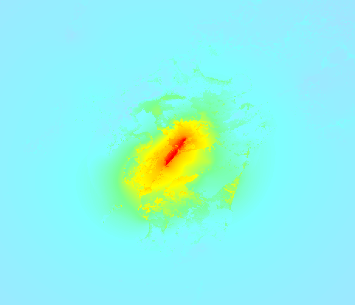
Earthquake Intensity Map
The maximum intensity (MMI Scale) caused by this earthquake is IX. The map below shows in which areas this earthquake was the most and least impactful. It is based on data from the US Geographic Survey.
Shaking reported by 95 people in 2 countries
People that feel an earthquake may report their experience to the US Geographic Survey. Currently, 95 people have reported shaking in 49 places in 2 countries (Japan, Korea (South)).We keep updating this article as more ground reports become available. You may report that you felt this earthquake here.
Places with most reports:
- Kumamoto, Kumamoto, Japan: 15 people.
- Matsubase, Kumamoto, Japan: 9 people.
- Fukuoka, Fukuoka, Japan: 5 people.
- Jonan, Kumamoto, Japan: 4 people.
- Yatsushiro, Kumamoto, Japan: 4 people.
- Uto, Kumamoto, Japan: 3 people.
- Kunitomi, Miyazaki, Japan: 3 people.
- Mashiki, Kumamoto, Japan: 3 people.
- Iwakuni, Yamaguchi, Japan: 3 people.
- Hiroshima, Hiroshima, Japan: 2 people.
113 Aftershocks detected
This main shock was followed by 113 smaller aftershocks. A 5.6 magnitude earthquake hit 41 mins later 27 km (17 mi) south of this earthquake.
This main shock was prefaced by 2 smaller foreshocks. A 4.2 magnitude earthquake hit 2 days earlier nearby.
Overview of foreshocks and aftershocks
| Classification | Magnitude | When | Where |
|---|---|---|---|
| Foreshock | M 4.2 |
2 days earlier Jul 27, 2026 02:00 (Tokyo Time) | 78 km (49 mi) SW from Main Shock. |
| Foreshock | M 3.7 |
7 hrs earlier Jul 28, 2026 09:39 (Tokyo Time) | 78 km (49 mi) SW from Main Shock. |
| Main Shock This Earthquake |
M 6.8 |
Jul 28, 2026 16:27 (Tokyo Time) | - |
| Aftershock | M 4.2 |
12 mins later Jul 28, 2026 16:39 (Tokyo Time) | 19 km (12 mi) NE from Main Shock. |
| Aftershock | M 4.5 |
13 mins later Jul 28, 2026 16:40 (Tokyo Time) | 26 km (16 mi) SE from Main Shock. |
| Aftershock | M 3.8 |
15 mins later Jul 28, 2026 16:42 (Tokyo Time) | 13 km (8 mi) NE from Main Shock. |
| Aftershock | M 4.3 |
18 mins later Jul 28, 2026 16:45 (Tokyo Time) | 6 km (4 mi) S from Main Shock. |
| Aftershock | M 3.4 |
23 mins later Jul 28, 2026 16:50 (Tokyo Time) | 2.6 km (1.6 mi) W from Main Shock. |
| Aftershock | M 3.6 |
26 mins later Jul 28, 2026 16:53 (Tokyo Time) | 17 km (10 mi) SW from Main Shock. |
| Aftershock | M 3.6 |
28 mins later Jul 28, 2026 16:55 (Tokyo Time) | 13 km (8 mi) NE from Main Shock. |
| Aftershock | M 4.3 |
32 mins later Jul 28, 2026 16:59 (Tokyo Time) | 9 km (5 mi) E from Main Shock. |
| Aftershock | M 3.3 |
36 mins later Jul 28, 2026 17:03 (Tokyo Time) | 13 km (8 mi) NE from Main Shock. |
| Aftershock | M 5.6 |
41 mins later Jul 28, 2026 17:08 (Tokyo Time) | 27 km (17 mi) S from Main Shock. |
| Aftershock | M 3.9 |
43 mins later Jul 28, 2026 17:10 (Tokyo Time) | 17 km (10 mi) SW from Main Shock. |
| Aftershock | M 3.1 |
47 mins later Jul 28, 2026 17:14 (Tokyo Time) | 19 km (12 mi) NE from Main Shock. |
| Aftershock | M 4.9 |
52 mins later Jul 28, 2026 17:18 (Tokyo Time) | 28 km (17 mi) S from Main Shock. |
| Aftershock | M 3.2 |
58 mins later Jul 28, 2026 17:25 (Tokyo Time) | 13 km (8 mi) NE from Main Shock. |
| Aftershock | M 3.4 |
1 hr later Jul 28, 2026 17:27 (Tokyo Time) | 7 km (4 mi) E from Main Shock. |
| Aftershock | M 3.4 |
1 hr later Jul 28, 2026 17:32 (Tokyo Time) | 14 km (8 mi) SE from Main Shock. |
| Aftershock | M 3.9 |
1 hr later Jul 28, 2026 17:37 (Tokyo Time) | 12 km (7 mi) S from Main Shock. |
| Aftershock | M 3.9 |
1 hr later Jul 28, 2026 17:43 (Tokyo Time) | 2.6 km (1.6 mi) W from Main Shock. |
| Aftershock | M 3.1 |
1 hr later Jul 28, 2026 17:45 (Tokyo Time) | 12 km (7 mi) S from Main Shock. |
| Aftershock | M 3.6 |
1 hr later Jul 28, 2026 17:50 (Tokyo Time) | 2.6 km (1.6 mi) W from Main Shock. |
| Aftershock | M 4.1 |
1 hr later Jul 28, 2026 17:54 (Tokyo Time) | 13 km (8 mi) NE from Main Shock. |
| Aftershock | M 4.3 |
2 hrs later Jul 28, 2026 17:57 (Tokyo Time) | 8 km (5 mi) S from Main Shock. |
| Aftershock | M 3.0 |
2 hrs later Jul 28, 2026 18:08 (Tokyo Time) | 27 km (17 mi) NE from Main Shock. |
| Aftershock | M 4.5 |
2 hrs later Jul 28, 2026 18:10 (Tokyo Time) | 23 km (14 mi) SW from Main Shock. |
| Aftershock | M 3.7 |
2 hrs later Jul 28, 2026 18:21 (Tokyo Time) | 17 km (10 mi) SW from Main Shock. |
| Aftershock | M 3.0 |
2 hrs later Jul 28, 2026 18:35 (Tokyo Time) | 2.6 km (1.6 mi) W from Main Shock. |
| Aftershock | M 3.1 |
2 hrs later Jul 28, 2026 18:37 (Tokyo Time) | 2.6 km (1.6 mi) W from Main Shock. |
| Aftershock | M 3.4 |
2 hrs later Jul 28, 2026 18:39 (Tokyo Time) | 19 km (12 mi) NE from Main Shock. |
| Aftershock | M 3.0 |
2 hrs later Jul 28, 2026 18:43 (Tokyo Time) | 12 km (7 mi) S from Main Shock. |
| Aftershock | M 3.3 |
2 hrs later Jul 28, 2026 18:50 (Tokyo Time) | 19 km (12 mi) NE from Main Shock. |
| Aftershock | M 4.2 |
2 hrs later Jul 28, 2026 18:56 (Tokyo Time) | 10 km (6 mi) N from Main Shock. |
| Aftershock | M 4.3 |
3 hrs later Jul 28, 2026 19:03 (Tokyo Time) | 12 km (8 mi) E from Main Shock. |
| Aftershock | M 3.3 |
3 hrs later Jul 28, 2026 19:07 (Tokyo Time) | 19 km (12 mi) NE from Main Shock. |
| Aftershock | M 4.4 |
3 hrs later Jul 28, 2026 19:09 (Tokyo Time) | 19 km (12 mi) S from Main Shock. |
| Aftershock | M 3.3 |
3 hrs later Jul 28, 2026 19:12 (Tokyo Time) | 12 km (7 mi) S from Main Shock. |
| Aftershock | M 3.4 |
3 hrs later Jul 28, 2026 19:33 (Tokyo Time) | 13 km (8 mi) NE from Main Shock. |
| Aftershock | M 3.3 |
3 hrs later Jul 28, 2026 19:43 (Tokyo Time) | 7 km (4 mi) E from Main Shock. |
| Aftershock | M 3.1 |
3 hrs later Jul 28, 2026 19:46 (Tokyo Time) | 17 km (10 mi) SW from Main Shock. |
| Aftershock | M 3.6 |
3 hrs later Jul 28, 2026 19:51 (Tokyo Time) | 12 km (7 mi) S from Main Shock. |
| Aftershock | M 3.0 |
3 hrs later Jul 28, 2026 19:53 (Tokyo Time) | 7 km (4 mi) E from Main Shock. |
| Aftershock | M 3.2 |
4 hrs later Jul 28, 2026 20:04 (Tokyo Time) | 19 km (12 mi) NE from Main Shock. |
| Aftershock | M 4.3 |
4 hrs later Jul 28, 2026 20:05 (Tokyo Time) | 19 km (11 mi) E from Main Shock. |
| Aftershock | M 3.0 |
4 hrs later Jul 28, 2026 20:11 (Tokyo Time) | 7 km (4 mi) E from Main Shock. |
| Aftershock | M 3.0 |
4 hrs later Jul 28, 2026 20:37 (Tokyo Time) | 14 km (8 mi) SE from Main Shock. |
| Aftershock | M 3.5 |
4 hrs later Jul 28, 2026 20:47 (Tokyo Time) | 40 km (25 mi) SW from Main Shock. |
| Aftershock | M 3.0 |
5 hrs later Jul 28, 2026 21:03 (Tokyo Time) | 12 km (7 mi) S from Main Shock. |
| Aftershock | M 3.2 |
5 hrs later Jul 28, 2026 21:07 (Tokyo Time) | 13 km (8 mi) NE from Main Shock. |
| Aftershock | M 4.4 |
5 hrs later Jul 28, 2026 21:10 (Tokyo Time) | 17 km (11 mi) SW from Main Shock. |
| Aftershock | M 3.0 |
5 hrs later Jul 28, 2026 21:13 (Tokyo Time) | 13 km (8 mi) NE from Main Shock. |
| Aftershock | M 4.6 |
5 hrs later Jul 28, 2026 21:26 (Tokyo Time) | 6 km (4 mi) E from Main Shock. |
| Aftershock | M 3.7 |
6 hrs later Jul 28, 2026 22:08 (Tokyo Time) | 7 km (4 mi) E from Main Shock. |
| Aftershock | M 3.1 |
6 hrs later Jul 28, 2026 22:11 (Tokyo Time) | 12 km (7 mi) S from Main Shock. |
| Aftershock | M 3.3 |
6 hrs later Jul 28, 2026 22:23 (Tokyo Time) | 19 km (12 mi) NE from Main Shock. |
| Aftershock | M 3.1 |
6 hrs later Jul 28, 2026 22:33 (Tokyo Time) | 19 km (12 mi) NE from Main Shock. |
| Aftershock | M 4.8 |
7 hrs later Jul 28, 2026 23:01 (Tokyo Time) | 12 km (7 mi) SW from Main Shock. |
| Aftershock | M 3.1 |
7 hrs later Jul 28, 2026 23:29 (Tokyo Time) | 12 km (7 mi) S from Main Shock. |
| Aftershock | M 3.5 |
7 hrs later Jul 28, 2026 23:49 (Tokyo Time) | 17 km (10 mi) SW from Main Shock. |
| Aftershock | M 4.1 |
8 hrs later Jul 29, 2026 00:15 (Tokyo Time) | 13 km (8 mi) NE from Main Shock. |
| Aftershock | M 3.4 |
8 hrs later Jul 29, 2026 00:22 (Tokyo Time) | 7 km (4 mi) E from Main Shock. |
| Aftershock | M 3.0 |
8 hrs later Jul 29, 2026 00:30 (Tokyo Time) | 7 km (4 mi) E from Main Shock. |
| Aftershock | M 3.2 |
9 hrs later Jul 29, 2026 00:59 (Tokyo Time) | 7 km (4 mi) E from Main Shock. |
| Aftershock | M 3.1 |
10 hrs later Jul 29, 2026 02:35 (Tokyo Time) | 13 km (8 mi) NE from Main Shock. |
| Aftershock | M 3.4 |
11 hrs later Jul 29, 2026 03:35 (Tokyo Time) | 17 km (10 mi) SW from Main Shock. |
| Aftershock | M 3.3 |
12 hrs later Jul 29, 2026 04:31 (Tokyo Time) | 2.6 km (1.6 mi) W from Main Shock. |
| Aftershock | M 4.1 |
12 hrs later Jul 29, 2026 04:38 (Tokyo Time) | 7 km (4 mi) E from Main Shock. |
| Aftershock | M 4.1 |
13 hrs later Jul 29, 2026 05:49 (Tokyo Time) | 7 km (4 mi) E from Main Shock. |
| Aftershock | M 3.7 |
14 hrs later Jul 29, 2026 05:58 (Tokyo Time) | 7 km (4 mi) E from Main Shock. |
| Aftershock | M 3.9 |
14 hrs later Jul 29, 2026 06:51 (Tokyo Time) | 13 km (8 mi) NE from Main Shock. |
| Aftershock | M 3.3 |
15 hrs later Jul 29, 2026 07:08 (Tokyo Time) | 2.6 km (1.6 mi) W from Main Shock. |
| Aftershock | M 3.2 |
16 hrs later Jul 29, 2026 08:22 (Tokyo Time) | 13 km (8 mi) NE from Main Shock. |
| Aftershock | M 3.0 |
16 hrs later Jul 29, 2026 08:35 (Tokyo Time) | 100 km (62 mi) NE from Main Shock. |
| Aftershock | M 3.1 |
16 hrs later Jul 29, 2026 08:42 (Tokyo Time) | 12 km (7 mi) S from Main Shock. |
| Aftershock | M 3.3 |
16 hrs later Jul 29, 2026 08:56 (Tokyo Time) | 12 km (7 mi) S from Main Shock. |
| Aftershock | M 3.1 |
18 hrs later Jul 29, 2026 10:30 (Tokyo Time) | 13 km (8 mi) NE from Main Shock. |
| Aftershock | M 3.0 |
19 hrs later Jul 29, 2026 11:37 (Tokyo Time) | 26 km (16 mi) SW from Main Shock. |
| Aftershock | M 3.9 |
20 hrs later Jul 29, 2026 12:08 (Tokyo Time) | 13 km (8 mi) NE from Main Shock. |
| Aftershock | M 3.1 |
21 hrs later Jul 29, 2026 13:09 (Tokyo Time) | 12 km (7 mi) S from Main Shock. |
| Aftershock | M 3.5 |
21 hrs later Jul 29, 2026 13:13 (Tokyo Time) | 12 km (7 mi) S from Main Shock. |
| Aftershock | M 4.4 |
24 hrs later Jul 29, 2026 15:59 (Tokyo Time) | 45 km (28 mi) NE from Main Shock. |
| Aftershock | M 3.4 |
24 hrs later Jul 29, 2026 16:11 (Tokyo Time) | 12 km (7 mi) S from Main Shock. |
| Aftershock | M 3.3 |
1 day later Jul 29, 2026 17:39 (Tokyo Time) | 40 km (25 mi) SW from Main Shock. |
| Aftershock | M 3.1 |
1 day later Jul 29, 2026 17:53 (Tokyo Time) | 2.6 km (1.6 mi) W from Main Shock. |
| Aftershock | M 3.3 |
1 day later Jul 29, 2026 18:02 (Tokyo Time) | 17 km (10 mi) SW from Main Shock. |
| Aftershock | M 3.0 |
1 day later Jul 29, 2026 18:41 (Tokyo Time) | 26 km (16 mi) SW from Main Shock. |
| Aftershock | M 3.1 |
1 day later Jul 29, 2026 18:44 (Tokyo Time) | 12 km (7 mi) S from Main Shock. |
| Aftershock | M 3.0 |
1 day later Jul 29, 2026 19:42 (Tokyo Time) | 7 km (4 mi) E from Main Shock. |
| Aftershock | M 3.2 |
1 day later Jul 29, 2026 20:35 (Tokyo Time) | 23 km (14 mi) S from Main Shock. |
| Aftershock | M 4.4 |
1 day later Jul 29, 2026 20:47 (Tokyo Time) | 18 km (11 mi) NW from Main Shock. |
| Aftershock | M 3.2 |
1 day later Jul 29, 2026 21:45 (Tokyo Time) | 13 km (8 mi) NE from Main Shock. |
| Aftershock | M 5.3 |
1 day later Jul 29, 2026 22:19 (Tokyo Time) | 33 km (20 mi) SW from Main Shock. |
| Aftershock | M 4.6 |
1 day later Jul 29, 2026 23:02 (Tokyo Time) | 15 km (9 mi) SW from Main Shock. |
| Aftershock | M 3.3 |
1 day later Jul 30, 2026 01:31 (Tokyo Time) | 12 km (7 mi) S from Main Shock. |
| Aftershock | M 3.5 |
1 day later Jul 30, 2026 03:35 (Tokyo Time) | 17 km (10 mi) SW from Main Shock. |
| Aftershock | M 3.3 |
1 day later Jul 30, 2026 03:59 (Tokyo Time) | 27 km (17 mi) NE from Main Shock. |
| Aftershock | M 3.4 |
1 day later Jul 30, 2026 04:02 (Tokyo Time) | 13 km (8 mi) NE from Main Shock. |
| Aftershock | M 4.8 |
2 days later Jul 30, 2026 05:16 (Tokyo Time) | 14 km (9 mi) SW from Main Shock. |
| Aftershock | M 3.0 |
2 days later Jul 30, 2026 06:10 (Tokyo Time) | 19 km (12 mi) NE from Main Shock. |
| Aftershock | M 3.0 |
2 days later Jul 30, 2026 06:25 (Tokyo Time) | 7 km (4 mi) E from Main Shock. |
| Aftershock | M 3.8 |
2 days later Jul 30, 2026 09:05 (Tokyo Time) | 12 km (7 mi) S from Main Shock. |
| Aftershock | M 4.4 |
2 days later Jul 30, 2026 09:56 (Tokyo Time) | 46 km (29 mi) SW from Main Shock. |
| Aftershock | M 3.3 |
2 days later Jul 30, 2026 11:13 (Tokyo Time) | 26 km (16 mi) SW from Main Shock. |
| Aftershock | M 4.0 |
2 days later Jul 30, 2026 11:43 (Tokyo Time) | 16 km (10 mi) S from Main Shock. |
| Aftershock | M 3.2 |
2 days later Jul 30, 2026 12:44 (Tokyo Time) | 17 km (10 mi) SW from Main Shock. |
| Aftershock | M 3.0 |
2 days later Jul 30, 2026 15:15 (Tokyo Time) | 54 km (34 mi) SW from Main Shock. |
| Aftershock | M 3.4 |
2 days later Jul 30, 2026 20:17 (Tokyo Time) | 17 km (10 mi) SW from Main Shock. |
| Aftershock | M 3.4 |
2 days later Jul 30, 2026 20:20 (Tokyo Time) | 12 km (7 mi) S from Main Shock. |
| Aftershock | M 5.0 |
2 days later Jul 30, 2026 22:47 (Tokyo Time) | 11 km (7 mi) N from Main Shock. |
| Aftershock | M 3.0 |
2 days later Jul 31, 2026 03:22 (Tokyo Time) | 26 km (16 mi) SW from Main Shock. |
| Aftershock | M 3.0 |
3 days later Jul 31, 2026 04:51 (Tokyo Time) | 12 km (7 mi) S from Main Shock. |
| Aftershock | M 3.3 |
3 days later Jul 31, 2026 07:50 (Tokyo Time) | 7 km (4 mi) E from Main Shock. |
| Aftershock | M 3.5 |
3 days later Jul 31, 2026 12:40 (Tokyo Time) | 12 km (7 mi) S from Main Shock. |
| Aftershock | M 3.1 |
3 days later Jul 31, 2026 13:07 (Tokyo Time) | 2.6 km (1.6 mi) W from Main Shock. |
| Aftershock | M 3.7 |
3 days later Jul 31, 2026 15:28 (Tokyo Time) | 7 km (4 mi) E from Main Shock. |
More earthquakes coming?
The risk of aftershocks decreases rapidly over time. Usually, aftershocks are at least one order of magnitude lower than a main shock.
It's always adviced to be cautious of the risk of a larger shock following any significant earthquake, however this risk is fairly small. There is a roughly 94 percent change that no larger main shock will follow in the days following this earthquake.
Read: How to Stay Safe during an Earthquake (cdc.gov).This is an unusually powerful earthquake
Earthquakes of this strength are not so common in the region, but it's not the first time. This is the strongest earthquake to hit since January 13th, 2025, when a 6.8 magnitude earthquake hit 122 km (76 mi) further south-east. An even stronger magnitude 7.1 earthquake struck on August 8th, 2024.
In total, 2 earthquakes with a magnitude of 6.8 or higher have been registered within 300km (186 mi) of this epicenter in the past 10 years. This comes down to an average of once every 5 years.
Sources
Last updated 26/09/26 05:28 (). This article contains currently available information about the earthquake and is automatically composed. We continue to update this article up to a few days after the earthquake occurred.
- US Geographic Society (USGS): Earthquake us6000tgb9
- European-Mediterranean Seismological Centre (EMSC): Earthquake 20260728_0000122
- Geonames.org: World Cities Database
- Google Maps: Static API
- Earthquakelist.org: Historic Earthquakes Database
Share this article:
