
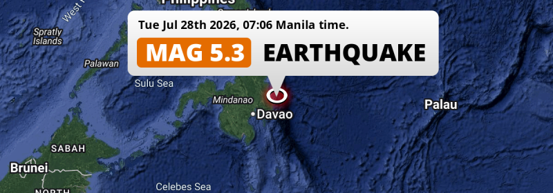
A significant MAG-5.3 earthquake struck in the Philippine Sea 135 kilometer from Davao, The Philippines in the morning of Tuesday July 28th, 2026.
Felt the earthquake? Share this article: 


Earthquake Summary
This earthquake hit under water in the Philippine Sea, right off the coast of The Philippines (9 mi offshore), 135 kilometer north-east of Davao. The center of this earthquake had an intermediate depth of 71 km.
| Date and Time: | Jul 28, 2026 07:06AM (Manila Time) - Jul 27, 2026 23:06 Universal Time. |
|---|---|
| Location: | 135 km NE of Davao, The Philippines. Coordinates 7°37'49"N 126°42'7"E. |
| Map: | 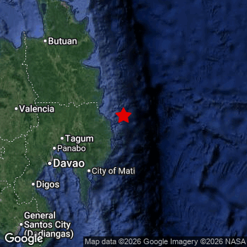 Map of area around epicenter. Click to open in Google Maps. |
| Magnitude: | MAG 5.3 Detected by 24 stations. Maximum Error Range ±0.037 . |
| Depth: | 71 km (44 mi) An intermediate depth. |
| Tsunami Risk: | Low tsunami risk Earthquakes under MAG-6.5 do not usually cause tsunami's. Always stay cautious - More info here. |
Nearby towns and cities
This earthquake may have been felt in The Philippines . The closest significant population center near the earthquake is Manay in Davao, The Philippines. Manay is located 50 kilometer (31 mi) north of the epicenter.
Major cities near this earthquake: Davao is located 135 km to the southwest. Budta is located 254 km to the west. Malingao is located 251 km to the west.
A complete list of nearby places is included below.
Overview of nearby places
| Distance | Place |
|---|---|
| 50 km (31 mi) S from epicenter |
Manay Davao, The Philippines. |
| 68 km (42 mi) W from epicenter |
Compostela Davao, The Philippines. |
| 74 km (46 mi) W from epicenter |
Monkayo Davao, The Philippines. |
| 78 km (48 mi) NW from epicenter |
Bislig Caraga, The Philippines. |
| 79 km (49 mi) W from epicenter |
San Mariano Davao, The Philippines. |
| 81 km (50 mi) W from epicenter |
Nabunturan Davao, The Philippines. |
| 84 km (52 mi) NW from epicenter |
Trento Caraga, The Philippines. |
| 92 km (57 mi) SW from epicenter |
Mati Davao, The Philippines. |
| 96 km (60 mi) NW from epicenter |
Veruela Caraga, The Philippines. |
| 97 km (60 mi) W from epicenter |
New Corella Davao, The Philippines. |
| 98 km (61 mi) NW from epicenter |
Bunawan Caraga, The Philippines. |
| 101 km (63 mi) W from epicenter |
Magugpo Poblacion Davao, The Philippines. |
| 110 km (68 mi) W from epicenter |
Cabayangan Davao, The Philippines. |
| 112 km (70 mi) SW from epicenter |
Lupon Davao, The Philippines. |
| 118 km (73 mi) W from epicenter |
Panabo Davao, The Philippines. |
| 126 km (78 mi) SW from epicenter |
Samal Davao, The Philippines. |
| 130 km (81 mi) NW from epicenter |
San Francisco Caraga, The Philippines. |
| 135 km (84 mi) SW from epicenter |
Davao Davao, The Philippines. |
| 137 km (85 mi) NW from epicenter |
Talacogon Caraga, The Philippines. |
| 139 km (86 mi) NW from epicenter |
Bah-Bah Caraga, The Philippines. |
| 162 km (101 mi) NW from epicenter |
Bayugan Caraga, The Philippines. |
| 170 km (106 mi) N from epicenter |
Tandag Caraga, The Philippines. |
| 177 km (110 mi) W from epicenter |
Quezon Northern Mindanao, The Philippines. |
| 178 km (111 mi) SW from epicenter |
Digos Davao, The Philippines. |
| 180 km (112 mi) W from epicenter |
NIA Valencia Northern Mindanao, The Philippines. |
| 181 km (112 mi) SW from epicenter |
Santa Maria Davao, The Philippines. |
| 181 km (112 mi) SW from epicenter |
Malita Davao, The Philippines. |
| 183 km (114 mi) W from epicenter |
Malaybalay Northern Mindanao, The Philippines. |
| 184 km (114 mi) W from epicenter |
Dologon Northern Mindanao, The Philippines. |
| 187 km (116 mi) W from epicenter |
Don Carlos Northern Mindanao, The Philippines. |
| 188 km (117 mi) W from epicenter |
Maramag Northern Mindanao, The Philippines. |
| 189 km (117 mi) SW from epicenter |
Bansalan Davao, The Philippines. |
| 191 km (119 mi) W from epicenter |
Kidapawan Soccsksargen, The Philippines. |
| 193 km (120 mi) SW from epicenter |
Magsaysay Davao, The Philippines. |
| 194 km (121 mi) NW from epicenter |
Butuan Caraga, The Philippines. |
| 197 km (122 mi) NW from epicenter |
Libertad Caraga, The Philippines. |
| 207 km (129 mi) NW from epicenter |
Buenavista Caraga, The Philippines. |
| 217 km (135 mi) SW from epicenter |
Maluñgun Soccsksargen, The Philippines. |
| 220 km (137 mi) NW from epicenter |
Mariano Northern Mindanao, The Philippines. |
| 239 km (149 mi) SW from epicenter |
General Santos Soccsksargen, The Philippines. |
| 239 km (149 mi) SW from epicenter |
Polomolok Soccsksargen, The Philippines. |
| 240 km (149 mi) SW from epicenter |
Koronadal Soccsksargen, The Philippines. |
| 245 km (152 mi) W from epicenter |
Cagayan de Oro Northern Mindanao, The Philippines. |
| 251 km (156 mi) W from epicenter |
Malingao Soccsksargen, The Philippines. |
| 254 km (158 mi) W from epicenter |
Budta Rehiyong Autonomo sa Muslim na Mindanao, The Philippines. |
| 263 km (163 mi) W from epicenter |
Iligan City Soccsksargen, The Philippines. |
| 270 km (168 mi) W from epicenter |
Marawi City Rehiyong Autonomo sa Muslim na Mindanao, The Philippines. |
| 274 km (170 mi) NW from epicenter |
Surigao Caraga, The Philippines. |
| 275 km (171 mi) W from epicenter |
Cotabato Rehiyong Autonomo sa Muslim na Mindanao, The Philippines. |
| 279 km (173 mi) W from epicenter |
Iligan Northern Mindanao, The Philippines. |
| 280 km (174 mi) W from epicenter |
Mantampay Northern Mindanao, The Philippines. |
Shaking reported by 3 people
People that feel an earthquake may report their experience to the US Geographic Survey. Currently, 3 people have reported shaking in 3 places, all within Philippines.We keep updating this article as more ground reports become available. You may report that you felt this earthquake here.
Places with most reports:
- Barra, Northern Mindanao, Philippines: 1 person.
- Canocotan, Southern Mindanao, Philippines: 1 person.
- Dapa, Caraga, Philippines: 1 person.
2 Aftershocks detected
Since this main shock, 2 smaller aftershocks were detected. At a distance of 66 km (41 mi) north of this earthquake, an aftershock struck 4 hrs later. It measured a magnitude of 3.4
Before this earthquake struck, 1 smaller foreshock occurred. Nearby this earthquake a foreshock struck 1 day earlier. It measured a magnitude of 3
Overview of foreshocks and aftershocks
| Classification | Magnitude | When | Where |
|---|---|---|---|
| Foreshock | M 3.0 |
1 day earlier Jul 27, 2026 01:04AM (Manila Time) | 48 km (30 mi) NW from Main Shock. |
| Main Shock This Earthquake |
M 5.3 |
Jul 28, 2026 07:06AM (Manila Time) | - |
| Aftershock | M 3.4 |
4 hrs later Jul 28, 2026 10:58AM (Manila Time) | 66 km (41 mi) N from Main Shock. |
| Aftershock | M 3.0 |
2 days later Jul 29, 2026 08:07PM (Manila Time) | 85 km (53 mi) S from Main Shock. |
More earthquakes coming?
The risk of aftershocks decreases rapidly over time. Usually, aftershocks are at least one order of magnitude lower than a main shock.
The chance that a significant earthquake like this one is followed by an even larger earthquake is not so large. On average, scientists estimate a 94% chance that a major earthquake will not be followed by an even larger one. It is still adviced to be aware of this risk
Read: How to Stay Safe during an Earthquake (cdc.gov).Earthquakes like this happen often in the region
Earthquakes of this strength are very common in the region. This is the strongest earthquake to hit since July 17th, 2026, when a 5.3 magnitude earthquake hit 261 km (162 mi) further southwest. An even stronger magnitude 7.8 earthquake struck on June 7th, 2026.
In total, 213 earthquakes with a magnitude of 5.3 or higher have been registered within 300km (186 mi) of this epicenter in the past 10 years. This comes down to an average of once every 17 days.
Low tsunami risk
Based on early data it appears this earthquake was not strong enough (lower than MAG-6.5) to be likely to cause destructive tsunami's. However this earthquake appeared to have hit at a shallow depth under sea, so stay cautious and monitor advice from local authorities.
Tsunami Risk Factors
| Factor | Under Sea? | MAG-6.5 or stronger? | Shallow depth? |
|---|---|---|---|
| Explanation | Almost all tsunami's are caused by earthquakes with their epicenter under sea or very near the sea. However stay cautious in coastal areas as earthquakes on land may cause landslides into sea, potentially still causing a local tsunami. | Under MAG 6.5: Very unlikely to cause a tsunami. MAG 6.5 to 7.5: Destructive tsunami's do occur, but are uncommon. Likely to observe small sea level changes. MAG 7.6+: Earthquakes with these magnitudes might produce destructive tsunami's. |
Most destructive tsunami's are caused by shallow earthquakes with a depth between 0 and 100km under the surface of the earth. Deeper tsunami's are unlikely to displace to ocean floor. |
| This Earthquake | This earthquake appears to have struck under the sea. | Not this earthquake. This earthquake had a magnitude of 5.3. Earthquakes of this strength are unlikely to trigger a tsunami. |
This earthquake occurred at a depth of of 71 km (44 mi). Earthquakes this shallow could trigger a tsunami. |
Sources
Last updated 20/08/26 01:28 (). This article is automatically generated based on available data. We keep checking multiple sources for additional information. This article gets updated as new details on this earthquake become available.
- US Geographic Society (USGS): Earthquake us6000tg94
- European-Mediterranean Seismological Centre (EMSC): Earthquake 20260727_0000389
- Geonames.org: World Cities Database
- Google Maps: Static API
- Earthquakelist.org: Historic Earthquakes Database
Share this article:
