
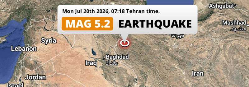
Under land 54 kilometer from Kahrīz in Iran, a shallow and significant Magnitude 5.2 earthquake occurred in the morning of Monday July 20th, 2026. Another country near the epicenter is Iraq.
Felt the earthquake? Share this article: 


Earthquake Summary
The earthquake struck on land in Iran, 54 kilometer (34 mi) west of Kahrīz in Kermānshāh. The center of this earthquake had a very shallow depth of 10 km. Shallow earthquakes usually have a larger impact than earthquakes deep in the earth.
| Date and Time: | Jul 20, 2026 07:18 (Tehran Time) - Jul 20, 2026 03:48 Universal Time. |
|---|---|
| Location: | 54 km west of Kahrīz, Kermānshāh, Iran. Coordinates 34°32'11"N 46°29'53"E. |
| Map: | 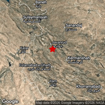 Map of area around epicenter. Click to open in Google Maps. |
| Magnitude: | MAG 5.2 Detected by 21 stations. Maximum Error Range ±0.068 . |
| Depth: | 10 km (6 mi) A very shallow depth. |
| Tsunami Risk: | Tsunami very unlikely While this was a shallow earthquake, it appears to have occurred under land with a magnitude not strong enough to cause tsunami's. Always stay cautious - More info here. |
Impact
The US Geographic Survey (USGS) describes the impact of this earthquake as follows:
At least 3 persons injured and some buildings damaged in the Kuzaran area.
Nearby towns and cities
This earthquake struck within proximity of multiple countries. Iran and Iraq are both within 300km distance of its epicenter.
Located 29 kilometer (18 mi) south of the epicenter of this earthquake, Javānrūd (Kermānshāh, Iran) is the nearest significant population center.
Multiple major population centers exist within 300km of the earthquake that struck today. Baghdad is located 235 km to the southwest. Kahrīz is located 54 km to the east. Kermanshah is located 58 km to the south-east.
A complete list of nearby places is included below.
Overview of nearby places
| Distance | Place |
|---|---|
| 29 km (18 mi) N from epicenter |
Javānrūd Kermānshāh, Iran. |
| 49 km (30 mi) NE from epicenter |
Kāmyārān Kordestān, Iran. |
| 54 km (34 mi) E from epicenter |
Kahrīz Kermānshāh, Iran. |
| 58 km (36 mi) N from epicenter |
Pāveh Kermānshāh, Iran. |
| 58 km (36 mi) SE from epicenter |
Kermanshah Kermānshāh, Iran. |
| 59 km (37 mi) W from epicenter |
Sarpol-e Z̄ahāb Kermānshāh, Iran. |
| 85 km (53 mi) NW from epicenter |
Ḩalabja Halabja Governorate, Iraq. |
| 98 km (61 mi) NE from epicenter |
Sanandaj Kordestān, Iran. |
| 100 km (62 mi) S from epicenter |
Īlām Ilam Province, Iran. |
| 104 km (65 mi) E from epicenter |
Sonqor Kermānshāh, Iran. |
| 104 km (65 mi) E from epicenter |
Harsīn Kermānshāh, Iran. |
| 113 km (70 mi) N from epicenter |
Marīvān Kordestān, Iran. |
| 123 km (76 mi) SW from epicenter |
Mandalī Diyālá, Iraq. |
| 130 km (81 mi) NW from epicenter |
Baynjiwayn Halabja Governorate, Iraq. |
| 134 km (83 mi) E from epicenter |
Kangāvar Kermānshāh, Iran. |
| 138 km (86 mi) NE from epicenter |
Qorveh Kordestān, Iran. |
| 142 km (88 mi) W from epicenter |
Kifrī Diyālá, Iraq. |
| 145 km (90 mi) E from epicenter |
Nūrābād Lorestan Province, Iran. |
| 150 km (93 mi) NW from epicenter |
As Sulaymānīyah Halabja Governorate, Iraq. |
| 151 km (94 mi) SE from epicenter |
Kūhdasht Lorestan Province, Iran. |
| 151 km (94 mi) E from epicenter |
Asadābād Hamadān, Iran. |
| 156 km (97 mi) SW from epicenter |
Al Miqdādīyah Diyālá, Iraq. |
| 172 km (107 mi) N from epicenter |
Bāneh Kordestān, Iran. |
| 175 km (109 mi) W from epicenter |
Ţūz Khūrmātū Salah ad Din, Iraq. |
| 175 km (109 mi) SE from epicenter |
Darreh Shahr Ilam Province, Iran. |
| 176 km (109 mi) E from epicenter |
Nahāvand Hamadān, Iran. |
| 179 km (111 mi) NE from epicenter |
Bījār Kordestān, Iran. |
| 179 km (111 mi) SE from epicenter |
Aleshtar Lorestan Province, Iran. |
| 182 km (113 mi) E from epicenter |
Bahār Hamadān, Iran. |
| 183 km (114 mi) E from epicenter |
Pasragad Branch Hamadān, Iran. |
| 187 km (116 mi) E from epicenter |
Hamadān Hamadān, Iran. |
| 188 km (117 mi) NW from epicenter |
Jamjamāl Halabja Governorate, Iraq. |
| 192 km (119 mi) N from epicenter |
Saqqez Kordestān, Iran. |
| 192 km (119 mi) E from epicenter |
Āzādshahr Hamadān, Iran. |
| 195 km (121 mi) SW from epicenter |
Baqubah Diyālá, Iraq. |
| 198 km (123 mi) SW from epicenter |
Khāliş Diyālá, Iraq. |
| 207 km (129 mi) SE from epicenter |
Khorramabad Lorestan Province, Iran. |
| 215 km (134 mi) E from epicenter |
Malāyer Hamadān, Iran. |
| 218 km (135 mi) NW from epicenter |
Kirkuk Kirkuk, Iraq. |
| 219 km (136 mi) E from epicenter |
Borūjerd Lorestan Province, Iran. |
| 222 km (138 mi) N from epicenter |
Būkān West Azerbaijan, Iran. |
| 231 km (144 mi) S from epicenter |
‘Alī al Gharbī Maysan, Iraq. |
| 234 km (145 mi) S from epicenter |
Al Kūt Wāsiţ, Iraq. |
| 235 km (146 mi) SW from epicenter |
Baghdad Baghdad, Iraq. |
| 243 km (151 mi) W from epicenter |
Sāmarrā’ Salah ad Din, Iraq. |
| 254 km (158 mi) SW from epicenter |
Abū Ghurayb Baghdad, Iraq. |
| 257 km (160 mi) N from epicenter |
Mahābād West Azerbaijan, Iran. |
| 272 km (169 mi) N from epicenter |
Mīāndoāb West Azerbaijan, Iran. |
| 283 km (176 mi) SW from epicenter |
Al Fallūjah Al Anbar, Iraq. |
| 283 km (176 mi) SW from epicenter |
Al Musayyib Bābil, Iraq. |
| 290 km (180 mi) NW from epicenter |
Erbil Arbīl, Iraq. |
| 298 km (185 mi) E from epicenter |
Arāk Markazi, Iran. |
| 298 km (185 mi) S from epicenter |
‘Afak Al Qādisīyah, Iraq. |
| 299 km (186 mi) NE from epicenter |
Zanjān Zanjan, Iran. |
Shaking reported by 2 people
People that feel an earthquake may report their experience to the US Geographic Survey. Currently, 2 people have reported shaking in 2 places in Iran.We keep updating this article as more ground reports become available. You may report that you felt this earthquake here.
Places with most reports:
- Bakhtaran, Kermānshāh, Iran: 1 person.
- Ecbatana, Hamadān, Iran: 1 person.
Aftershocks detected
Before this earthquake struck, 1 smaller foreshock occurred. Nearby this earthquake a foreshock struck 6 mins earlier. It measured a magnitude of 4.8
Overview of foreshocks and aftershocks
| Classification | Magnitude | When | Where |
|---|---|---|---|
| Foreshock | M 4.8 |
6 mins earlier Jul 20, 2026 07:13 (Tehran Time) | 3 km (1.9 mi) N from Main Shock. |
| Main Shock This Earthquake |
M 5.2 |
Jul 20, 2026 07:18 (Tehran Time) | - |
More earthquakes coming?
Aftershocks are usually at least 1 order of magnitude less strong than main shocks. The more time passes, the smaller the chance and likely strength of any potential aftershocks.
The chance that a significant earthquake like this one is followed by an even larger earthquake is not so large. On average, scientists estimate a 94% chance that a major earthquake will not be followed by an even larger one. It is still adviced to be aware of this risk
Read: How to Stay Safe during an Earthquake (cdc.gov).This is the strongest earthquake in 5 years
Earthquakes of this strength are very common in the region. This is the strongest earthquake to hit since June 6th, 2021, when a 5.3 magnitude earthquake hit 131 km (81 mi) further south. An even stronger magnitude 7.3 earthquake struck on November 12th, 2017.
In total, 14 earthquakes with a magnitude of 5.2 or higher have been registered within 300km (186 mi) of this epicenter in the past 10 years. This comes down to an average of once every 9 months.
Tsunami very unlikely
While MAG-6.5+ earthquakes may cause tsunami's, it appears that the epicenter of this earthquake hit under land. In addition, the reported depth is deeper than 100km, making the risk of a tsunami even less likely. However always stay cautious and monitor advice from local authorities.
Tsunami Risk Factors
| Factor | Under Sea? | MAG-6.5 or stronger? | Shallow depth? |
|---|---|---|---|
| Explanation | Almost all tsunami's are caused by earthquakes with their epicenter under sea or very near the sea. However stay cautious in coastal areas as earthquakes on land may cause landslides into sea, potentially still causing a local tsunami. | Under MAG 6.5: Very unlikely to cause a tsunami. MAG 6.5 to 7.5: Destructive tsunami's do occur, but are uncommon. Likely to observe small sea level changes. MAG 7.6+: Earthquakes with these magnitudes might produce destructive tsunami's. |
Most destructive tsunami's are caused by shallow earthquakes with a depth between 0 and 100km under the surface of the earth. Deeper tsunami's are unlikely to displace to ocean floor. |
| This Earthquake | Not this earthquake. This earthquake appears to have struck on land far from any coast. |
Not this earthquake. This earthquake had a magnitude of 5.2. Earthquakes of this strength are unlikely to trigger a tsunami. |
This earthquake occurred at a depth of of 10 km (6 mi). Earthquakes this shallow could trigger a tsunami. |
Sources
Last updated 18/08/26 02:28 (). As more information on this earthquake becomes available this article will be updated. This article is automatically composed based on data originating from multiple sources.
- US Geographic Society (USGS): Earthquake us7000t1vq
- European-Mediterranean Seismological Centre (EMSC): Earthquake 20260720_0000066
- Geonames.org: World Cities Database
- Google Maps: Static API
- Earthquakelist.org: Historic Earthquakes Database
Share this article:
