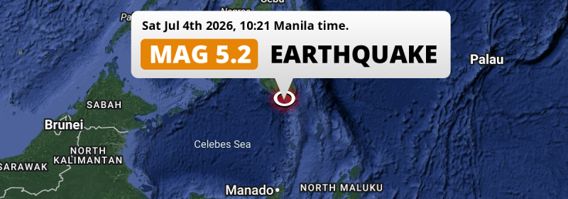
A shallow and significant MAG-5.0 foreshock struck in the Sulawesi Sea 73 kilometer from General Santos, The Philippines in the morning of Saturday July 4th, 2026.
Felt the earthquake? Share this article: 


Earthquake Summary
This earthquake hit under water in the Sulawesi Sea, right off the coast of The Philippines (7 mi offshore), 73 kilometer south of General Santos in Soccsksargen. The center of this earthquake had a very shallow depth of 10 km. Shallow earthquakes usually have a larger impact than earthquakes deep in the earth.
| Date and Time: | Jul 4, 2026 10:21AM (Manila Time) - Jul 4, 2026 02:21 Universal Time. |
|---|---|
| Location: | 73 km south of General Santos, Soccsksargen, The Philippines. Coordinates 5°27'51"N 125°17'12"E. |
| Map: | 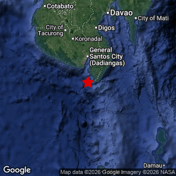 Map of area around epicenter. Click to open in Google Maps. |
| Magnitude: | MAG 5.0 Detected by 62 stations. Maximum Error Range ±0.072 . |
| Depth: | 10 km (6 mi) A very shallow depth. |
| Tsunami Risk: | Low tsunami risk Earthquakes under MAG-6.5 do not usually cause tsunami's. Always stay cautious - More info here. |
Nearby towns and cities
This earthquake may have been felt in The Philippines . The closest significant population center near the earthquake is Glan in Soccsksargen, The Philippines. Glan is located 41 kilometer (25 mi) south of the epicenter.
Major cities near this earthquake: General Santos is located 73 km to the north. Davao is located 183 km to the north. Budta is located 215 km to the northwest.
A complete list of nearby places is included below.
Overview of nearby places
| Distance | Place |
|---|---|
| 41 km (25 mi) N from epicenter |
Glan Soccsksargen, The Philippines. |
| 56 km (35 mi) N from epicenter |
Malapatan Soccsksargen, The Philippines. |
| 71 km (44 mi) N from epicenter |
Alabel Soccsksargen, The Philippines. |
| 73 km (45 mi) N from epicenter |
General Santos Soccsksargen, The Philippines. |
| 88 km (55 mi) N from epicenter |
Polomolok Soccsksargen, The Philippines. |
| 91 km (57 mi) N from epicenter |
Maluñgun Soccsksargen, The Philippines. |
| 104 km (65 mi) N from epicenter |
Tupi Soccsksargen, The Philippines. |
| 106 km (66 mi) NW from epicenter |
Lake Sebu Soccsksargen, The Philippines. |
| 112 km (70 mi) N from epicenter |
Malita Davao, The Philippines. |
| 118 km (73 mi) NW from epicenter |
Surallah Soccsksargen, The Philippines. |
| 121 km (75 mi) NW from epicenter |
Bañga Soccsksargen, The Philippines. |
| 123 km (76 mi) N from epicenter |
Santa Maria Davao, The Philippines. |
| 125 km (78 mi) NW from epicenter |
Koronadal Soccsksargen, The Philippines. |
| 143 km (89 mi) N from epicenter |
Digos Davao, The Philippines. |
| 145 km (90 mi) N from epicenter |
Magsaysay Davao, The Philippines. |
| 147 km (91 mi) N from epicenter |
Bansalan Davao, The Philippines. |
| 150 km (93 mi) NW from epicenter |
Isulan Soccsksargen, The Philippines. |
| 150 km (93 mi) N from epicenter |
Buluan Rehiyong Autonomo sa Muslim na Mindanao, The Philippines. |
| 152 km (94 mi) NW from epicenter |
Tacurong Soccsksargen, The Philippines. |
| 159 km (99 mi) NW from epicenter |
Laguilayan Soccsksargen, The Philippines. |
| 173 km (107 mi) N from epicenter |
Kidapawan Soccsksargen, The Philippines. |
| 178 km (111 mi) NE from epicenter |
Lupon Davao, The Philippines. |
| 182 km (113 mi) NW from epicenter |
Maganoy Rehiyong Autonomo sa Muslim na Mindanao, The Philippines. |
| 183 km (114 mi) N from epicenter |
Davao Davao, The Philippines. |
| 185 km (115 mi) N from epicenter |
Samal Davao, The Philippines. |
| 190 km (118 mi) N from epicenter |
Kabacan Soccsksargen, The Philippines. |
| 195 km (121 mi) NE from epicenter |
Mati Davao, The Philippines. |
| 209 km (130 mi) NW from epicenter |
Malingao Soccsksargen, The Philippines. |
| 209 km (130 mi) NW from epicenter |
Midsayap Soccsksargen, The Philippines. |
| 210 km (130 mi) N from epicenter |
Panabo Davao, The Philippines. |
| 212 km (132 mi) NW from epicenter |
Pagaluñgan Rehiyong Autonomo sa Muslim na Mindanao, The Philippines. |
| 215 km (134 mi) NW from epicenter |
Budta Rehiyong Autonomo sa Muslim na Mindanao, The Philippines. |
| 222 km (138 mi) N from epicenter |
Cabayangan Davao, The Philippines. |
| 227 km (141 mi) NW from epicenter |
Cotabato Rehiyong Autonomo sa Muslim na Mindanao, The Philippines. |
| 228 km (142 mi) N from epicenter |
Magugpo Poblacion Davao, The Philippines. |
| 239 km (149 mi) NE from epicenter |
Manay Davao, The Philippines. |
| 240 km (149 mi) N from epicenter |
San Mariano Davao, The Philippines. |
| 240 km (149 mi) NW from epicenter |
Parang Rehiyong Autonomo sa Muslim na Mindanao, The Philippines. |
| 243 km (151 mi) N from epicenter |
New Corella Davao, The Philippines. |
| 248 km (154 mi) N from epicenter |
Don Carlos Northern Mindanao, The Philippines. |
| 250 km (155 mi) N from epicenter |
Nabunturan Davao, The Philippines. |
| 253 km (157 mi) N from epicenter |
Quezon Northern Mindanao, The Philippines. |
| 256 km (159 mi) N from epicenter |
Wao Rehiyong Autonomo sa Muslim na Mindanao, The Philippines. |
| 258 km (160 mi) N from epicenter |
Maramag Northern Mindanao, The Philippines. |
| 261 km (162 mi) N from epicenter |
Compostela Davao, The Philippines. |
| 266 km (165 mi) N from epicenter |
Dologon Northern Mindanao, The Philippines. |
| 272 km (169 mi) N from epicenter |
NIA Valencia Northern Mindanao, The Philippines. |
| 275 km (171 mi) N from epicenter |
Monkayo Davao, The Philippines. |
| 299 km (186 mi) N from epicenter |
Veruela Caraga, The Philippines. |
| 300 km (186 mi) N from epicenter |
Trento Caraga, The Philippines. |
Shaking reported by 3 people
People that feel an earthquake may report their experience to the US Geographic Survey. Currently, 3 people have reported shaking in 3 places, all within Philippines.We keep updating this article as more ground reports become available. You may report that you felt this earthquake here.
Places with most reports:
- Katangawan, Southern Mindanao, Philippines: 1 person.
- Padada, Southern Mindanao, Philippines: 1 person.
- Buayan, Southern Mindanao, Philippines: 1 person.
This is likely a foreshock
This earthquake was followed by a stronger MAG-5.8 earthquake, classifying this earthquake as a foreshock.
Overview of foreshocks and aftershocks
| Classification | Magnitude | When | Where |
|---|---|---|---|
| Foreshock | M 3.8 |
5 days earlier Jul 1, 2026 01:48PM (Manila Time) | 38 km (23 mi) N from Main Shock. |
| Foreshock | M 3.5 |
5 days earlier Jul 1, 2026 07:59PM (Manila Time) | 58 km (36 mi) S from Main Shock. |
| Foreshock | M 3.2 |
5 days earlier Jul 1, 2026 10:43PM (Manila Time) | 50 km (31 mi) N from Main Shock. |
| Foreshock | M 3.0 |
5 days earlier Jul 1, 2026 10:55PM (Manila Time) | 65 km (41 mi) N from Main Shock. |
| Foreshock | M 4.2 |
5 days earlier Jul 2, 2026 02:10AM (Manila Time) | 81 km (50 mi) NW from Main Shock. |
| Foreshock | M 4.0 |
5 days earlier Jul 2, 2026 02:10AM (Manila Time) | 54 km (33 mi) NE from Main Shock. |
| Foreshock | M 3.4 |
5 days earlier Jul 2, 2026 03:22AM (Manila Time) | 46 km (29 mi) NW from Main Shock. |
| Foreshock | M 3.5 |
4 days earlier Jul 2, 2026 10:49AM (Manila Time) | 70 km (44 mi) N from Main Shock. |
| Foreshock | M 3.8 |
4 days earlier Jul 2, 2026 12:49PM (Manila Time) | 28 km (17 mi) S from Main Shock. |
| Foreshock | M 3.7 |
4 days earlier Jul 2, 2026 02:00PM (Manila Time) | 41 km (26 mi) NE from Main Shock. |
| Foreshock | M 3.0 |
4 days earlier Jul 2, 2026 02:34PM (Manila Time) | 81 km (50 mi) NW from Main Shock. |
| Foreshock | M 4.0 |
4 days earlier Jul 2, 2026 03:33PM (Manila Time) | 30 km (19 mi) NE from Main Shock. |
| Foreshock | M 3.6 |
4 days earlier Jul 2, 2026 03:47PM (Manila Time) | 44 km (27 mi) N from Main Shock. |
| Foreshock | M 3.1 |
4 days earlier Jul 2, 2026 05:35PM (Manila Time) | 14 km (9 mi) SW from Main Shock. |
| Foreshock | M 3.2 |
4 days earlier Jul 2, 2026 06:29PM (Manila Time) | 60 km (37 mi) S from Main Shock. |
| Foreshock | M 4.3 |
4 days earlier Jul 2, 2026 07:26PM (Manila Time) | 72 km (44 mi) N from Main Shock. |
| Foreshock | M 3.0 |
4 days earlier Jul 2, 2026 07:31PM (Manila Time) | 68 km (42 mi) N from Main Shock. |
| Foreshock | M 3.7 |
4 days earlier Jul 2, 2026 11:19PM (Manila Time) | 68 km (42 mi) N from Main Shock. |
| Foreshock | M 3.5 |
4 days earlier Jul 3, 2026 01:15AM (Manila Time) | 95 km (59 mi) W from Main Shock. |
| Foreshock | M 4.3 |
4 days earlier Jul 3, 2026 02:13AM (Manila Time) | 74 km (46 mi) N from Main Shock. |
| Foreshock | M 4.3 |
4 days earlier Jul 3, 2026 02:13AM (Manila Time) | 74 km (46 mi) N from Main Shock. |
| Foreshock | M 3.4 |
4 days earlier Jul 3, 2026 03:58AM (Manila Time) | 66 km (41 mi) N from Main Shock. |
| Foreshock | M 3.0 |
3 days earlier Jul 3, 2026 06:45AM (Manila Time) | 67 km (42 mi) N from Main Shock. |
| Foreshock | M 3.2 |
3 days earlier Jul 3, 2026 07:00AM (Manila Time) | 42 km (26 mi) N from Main Shock. |
| Foreshock | M 3.4 |
3 days earlier Jul 3, 2026 07:02AM (Manila Time) | 79 km (49 mi) NE from Main Shock. |
| Foreshock | M 3.3 |
3 days earlier Jul 3, 2026 03:21PM (Manila Time) | 89 km (55 mi) N from Main Shock. |
| Foreshock | M 4.9 |
3 days earlier Jul 3, 2026 06:08PM (Manila Time) | 33 km (20 mi) NW from Main Shock. |
| Foreshock | M 4.9 |
3 days earlier Jul 3, 2026 06:10PM (Manila Time) | 32 km (20 mi) N from Main Shock. |
| Foreshock | M 3.3 |
3 days earlier Jul 3, 2026 06:17PM (Manila Time) | 86 km (53 mi) E from Main Shock. |
| Foreshock | M 4.3 |
3 days earlier Jul 3, 2026 07:51PM (Manila Time) | 37 km (23 mi) NE from Main Shock. |
| Foreshock | M 3.0 |
3 days earlier Jul 3, 2026 08:10PM (Manila Time) | 95 km (59 mi) E from Main Shock. |
| Foreshock | M 3.0 |
3 days earlier Jul 3, 2026 08:14PM (Manila Time) | 67 km (42 mi) N from Main Shock. |
| Foreshock | M 4.1 |
3 days earlier Jul 3, 2026 10:05PM (Manila Time) | 88 km (55 mi) N from Main Shock. |
| Foreshock | M 4.7 |
3 days earlier Jul 4, 2026 03:09AM (Manila Time) | 65 km (40 mi) NW from Main Shock. |
| Foreshock | M 3.7 |
3 days earlier Jul 4, 2026 03:41AM (Manila Time) | 19 km (11 mi) NE from Main Shock. |
| Foreshock | M 4.4 |
3 days earlier Jul 4, 2026 03:50AM (Manila Time) | 53 km (33 mi) NE from Main Shock. |
| Foreshock | M 4.5 |
2 days earlier Jul 4, 2026 10:13AM (Manila Time) | 64 km (40 mi) NW from Main Shock. |
| Foreshock This Earthquake |
M 5.0 |
2 days earlier Jul 4, 2026 10:21AM (Manila Time) | 53 km (33 mi) N from Main Shock. |
| Foreshock | M 4.8 |
2 days earlier Jul 4, 2026 12:26PM (Manila Time) | 54 km (33 mi) N from Main Shock. |
| Foreshock | M 3.7 |
2 days earlier Jul 4, 2026 03:32PM (Manila Time) | 73 km (45 mi) NE from Main Shock. |
| Foreshock | M 3.3 |
2 days earlier Jul 4, 2026 04:06PM (Manila Time) | 58 km (36 mi) NW from Main Shock. |
| Foreshock | M 3.2 |
2 days earlier Jul 4, 2026 04:30PM (Manila Time) | 51 km (32 mi) N from Main Shock. |
| Foreshock | M 4.9 |
2 days earlier Jul 4, 2026 04:53PM (Manila Time) | 26 km (16 mi) NW from Main Shock. |
| Foreshock | M 3.4 |
2 days earlier Jul 4, 2026 07:56PM (Manila Time) | 87 km (54 mi) NE from Main Shock. |
| Foreshock | M 3.7 |
2 days earlier Jul 4, 2026 08:47PM (Manila Time) | 66 km (41 mi) N from Main Shock. |
| Foreshock | M 4.2 |
2 days earlier Jul 4, 2026 08:47PM (Manila Time) | 70 km (43 mi) N from Main Shock. |
| Foreshock | M 3.4 |
2 days earlier Jul 4, 2026 09:15PM (Manila Time) | 15 km (9 mi) SW from Main Shock. |
| Foreshock | M 3.3 |
2 days earlier Jul 5, 2026 02:08AM (Manila Time) | 41 km (25 mi) N from Main Shock. |
| Foreshock | M 3.0 |
2 days earlier Jul 5, 2026 03:43AM (Manila Time) | 88 km (55 mi) N from Main Shock. |
| Foreshock | M 3.1 |
1 day earlier Jul 5, 2026 05:44AM (Manila Time) | 92 km (57 mi) NE from Main Shock. |
| Foreshock | M 3.4 |
1 day earlier Jul 5, 2026 03:08PM (Manila Time) | 56 km (34 mi) NE from Main Shock. |
| Foreshock | M 3.0 |
21 hrs earlier Jul 5, 2026 07:00PM (Manila Time) | 85 km (53 mi) N from Main Shock. |
| Foreshock | M 3.3 |
19 hrs earlier Jul 5, 2026 09:10PM (Manila Time) | 60 km (37 mi) N from Main Shock. |
| Foreshock | M 3.7 |
17 hrs earlier Jul 5, 2026 11:02PM (Manila Time) | 86 km (53 mi) N from Main Shock. |
| Foreshock | M 3.1 |
2 hrs earlier Jul 6, 2026 02:21PM (Manila Time) | 91 km (56 mi) W from Main Shock. |
| Main Shock | M 5.8 |
Jul 6, 2026 04:11PM (Manila Time) | - |
| Aftershock | M 5.4 |
30 mins later Jul 6, 2026 04:41PM (Manila Time) | 22 km (14 mi) SW from Main Shock. |
| Aftershock | M 3.9 |
55 mins later Jul 6, 2026 05:06PM (Manila Time) | 63 km (39 mi) NE from Main Shock. |
| Aftershock | M 3.9 |
2 hrs later Jul 6, 2026 06:13PM (Manila Time) | 27 km (17 mi) NE from Main Shock. |
| Aftershock | M 3.7 |
2 hrs later Jul 6, 2026 06:27PM (Manila Time) | 56 km (35 mi) NE from Main Shock. |
| Aftershock | M 3.6 |
3 hrs later Jul 6, 2026 06:42PM (Manila Time) | 47 km (29 mi) S from Main Shock. |
| Aftershock | M 3.8 |
3 hrs later Jul 6, 2026 07:11PM (Manila Time) | 54 km (34 mi) NE from Main Shock. |
| Aftershock | M 3.0 |
3 hrs later Jul 6, 2026 07:18PM (Manila Time) | 13 km (8 mi) NW from Main Shock. |
| Aftershock | M 4.0 |
5 hrs later Jul 6, 2026 09:20PM (Manila Time) | 28 km (17 mi) E from Main Shock. |
| Aftershock | M 4.4 |
5 hrs later Jul 6, 2026 09:21PM (Manila Time) | 20 km (12 mi) SE from Main Shock. |
| Aftershock | M 4.3 |
9 hrs later Jul 7, 2026 01:13AM (Manila Time) | 40 km (25 mi) NE from Main Shock. |
| Aftershock | M 4.3 |
10 hrs later Jul 7, 2026 01:48AM (Manila Time) | 72 km (45 mi) N from Main Shock. |
| Aftershock | M 3.7 |
10 hrs later Jul 7, 2026 02:09AM (Manila Time) | 19 km (12 mi) NE from Main Shock. |
| Aftershock | M 3.8 |
13 hrs later Jul 7, 2026 05:30AM (Manila Time) | 35 km (22 mi) E from Main Shock. |
| Aftershock | M 3.1 |
13 hrs later Jul 7, 2026 05:38AM (Manila Time) | 24 km (15 mi) SW from Main Shock. |
| Aftershock | M 3.0 |
16 hrs later Jul 7, 2026 07:54AM (Manila Time) | 67 km (42 mi) N from Main Shock. |
| Aftershock | M 4.4 |
22 hrs later Jul 7, 2026 02:05PM (Manila Time) | 43 km (27 mi) E from Main Shock. |
| Aftershock | M 3.8 |
1 day later Jul 7, 2026 08:43PM (Manila Time) | 55 km (34 mi) NE from Main Shock. |
| Aftershock | M 3.0 |
1 day later Jul 7, 2026 11:01PM (Manila Time) | 23 km (14 mi) W from Main Shock. |
| Aftershock | M 3.1 |
1 day later Jul 8, 2026 03:14AM (Manila Time) | 21 km (13 mi) NW from Main Shock. |
| Aftershock | M 3.4 |
2 days later Jul 8, 2026 05:14AM (Manila Time) | 84 km (52 mi) N from Main Shock. |
| Aftershock | M 3.2 |
2 days later Jul 8, 2026 05:27AM (Manila Time) | 93 km (58 mi) N from Main Shock. |
| Aftershock | M 3.1 |
2 days later Jul 8, 2026 11:51AM (Manila Time) | 55 km (34 mi) N from Main Shock. |
| Aftershock | M 4.0 |
2 days later Jul 8, 2026 12:36PM (Manila Time) | 51 km (32 mi) NE from Main Shock. |
| Aftershock | M 4.3 |
2 days later Jul 8, 2026 12:36PM (Manila Time) | 49 km (30 mi) NW from Main Shock. |
| Aftershock | M 3.9 |
2 days later Jul 8, 2026 03:49PM (Manila Time) | 33 km (21 mi) NE from Main Shock. |
| Aftershock | M 4.3 |
2 days later Jul 8, 2026 09:35PM (Manila Time) | 65 km (40 mi) W from Main Shock. |
| Aftershock | M 3.7 |
2 days later Jul 8, 2026 10:59PM (Manila Time) | 36 km (22 mi) NE from Main Shock. |
| Aftershock | M 3.5 |
3 days later Jul 9, 2026 04:12AM (Manila Time) | 31 km (19 mi) S from Main Shock. |
| Aftershock | M 3.1 |
3 days later Jul 9, 2026 05:54AM (Manila Time) | 61 km (38 mi) NW from Main Shock. |
| Aftershock | M 3.9 |
3 days later Jul 9, 2026 12:00PM (Manila Time) | 21 km (13 mi) SE from Main Shock. |
| Aftershock | M 3.9 |
3 days later Jul 9, 2026 12:55PM (Manila Time) | 98 km (61 mi) E from Main Shock. |
More earthquakes coming?
The risk of aftershocks decreases rapidly over time. Usually, aftershocks are at least one order of magnitude lower than a main shock.
In only six percent of cases, significant earthquakes are followed by a larger main shock, making the current earthquake a foreshock. While the chance of this happening is not so large, it is adviced to maintain cautiousness in the hours and days following a major earthquake.
Read: How to Stay Safe during an Earthquake (cdc.gov).Earthquakes like this happen often in the region
Earthquakes of this strength are very common in the region. This is the strongest earthquake to hit since June 29th, 2026, when a 5.2 magnitude earthquake hit 98 km (61 mi) further south. An even stronger magnitude 7.8 earthquake struck on June 7th, 2026.
In total, 402 earthquakes with a magnitude of 5 or higher have been registered within 300km (186 mi) of this epicenter in the past 10 years. This comes down to an average of once every 9 days.
Low tsunami risk
Based on early data it appears this earthquake was not strong enough (lower than MAG-6.5) to be likely to cause destructive tsunami's. However this earthquake appeared to have hit at a shallow depth under sea, so stay cautious and monitor advice from local authorities.
Tsunami Risk Factors
| Factor | Under Sea? | MAG-6.5 or stronger? | Shallow depth? |
|---|---|---|---|
| Explanation | Almost all tsunami's are caused by earthquakes with their epicenter under sea or very near the sea. However stay cautious in coastal areas as earthquakes on land may cause landslides into sea, potentially still causing a local tsunami. | Under MAG 6.5: Very unlikely to cause a tsunami. MAG 6.5 to 7.5: Destructive tsunami's do occur, but are uncommon. Likely to observe small sea level changes. MAG 7.6+: Earthquakes with these magnitudes might produce destructive tsunami's. |
Most destructive tsunami's are caused by shallow earthquakes with a depth between 0 and 100km under the surface of the earth. Deeper tsunami's are unlikely to displace to ocean floor. |
| This Earthquake | This earthquake appears to have struck under the sea. | Not this earthquake. This earthquake had a magnitude of 5. Earthquakes of this strength are unlikely to trigger a tsunami. |
This earthquake occurred at a depth of of 10 km (6 mi). Earthquakes this shallow could trigger a tsunami. |
Sources
Last updated 26/07/26 00:58 (). As more information on this earthquake becomes available this article will be updated. This article is automatically composed based on data originating from multiple sources.
- US Geographic Society (USGS): Earthquake us6000ta14
- European-Mediterranean Seismological Centre (EMSC): Earthquake 20260704_0000030
- Geonames.org: World Cities Database
- Google Maps: Static API
- Earthquakelist.org: Historic Earthquakes Database
Share this article:
