A shallow and strong M6.1 earthquake struck in the East China Sea 191 kilometer from Naha, Japan in the early afternoon of Friday July 3rd, 2026. Shaking may have been felt by a total of 1.1 million people.
Felt the earthquake? Share this article: 


Earthquake Summary
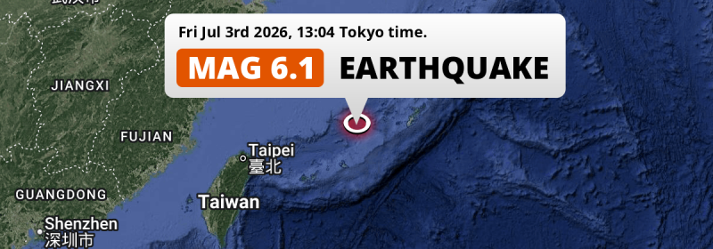
This earthquake hit under water in the East China Sea, 132 kilometers (82 mi) off the coast of Japan, 191 kilometer west of Naha in Okinawa. The center of this earthquake had a very shallow depth of 10 km. Shallow earthquakes usually have a larger impact than earthquakes deep in the earth.
| Date and Time: | Jul 3, 2026 13:04 (Tokyo Time) - Jul 3, 2026 04:04 Universal Time. |
|---|---|
| Location: | 191 km west of Naha, Okinawa, Japan. Coordinates 25°57'0"N 125°47'39"E. |
| Map: | 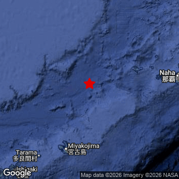 Map of area around epicenter. Click to open in Google Maps. |
| Magnitude: | MAG 6.1 Detected by 46 stations. Maximum Error Range ±0.046 . |
| Depth: | 10 km (6 mi) A very shallow depth. |
| Max. Intensity: | V
Moderate On the Modified Mercalli Scale. |
| Tsunami Risk: | Low tsunami risk Earthquakes under MAG-6.5 do not usually cause tsunami's. Always stay cautious - More info here. |
Minimal impact predicted
Based on scientific estimates by the US Geographic Survey (USGS), the risk of high fatalities for this earthquake is classified at level GREEN (low). They expect an 90% likelyhood of between 0 and 1 fatalities.
The USGS classifies the economic impact of this earthquake at level GREEN (low). They expect an 90% likelyhood of between 0 and 1 million US Dollars in economic damage and impact.
Roughly 1.1 million people exposed to shaking
This earthquake may have been felt by around 1.1 million people. That is the expected population size of the area exposed to a level of shaking of II or higher on the Modified Mercalli scale according to the USGS.
The highest earthquake impact level for this earthquake is IV, which corresponds with light shaking and likely no damage. Roughly 571,900 people are expected to be exposed to this level. All exposure to shaking was within the borders of Japan .
| People | MMI Level | Shaking | Damage |
|---|---|---|---|
| 0 | I |
Not noticable | None |
| 0 | II |
Very weak | None |
| 553,200 | III |
Weak | Probably none |
| 571,900 | IV |
Light | Likely none |
| 0 | V |
Moderate | Very light |
| 0 | VI |
Strong | Light |
| 0 | VII |
Very Strong | Moderate |
| 0 | VIII |
Severe | Moderate to heavy |
| 0 | IX |
Violent | Heavy |
| 0 | X |
Extreme | Very heavy |
Nearby towns and cities
This earthquake may have been felt in Japan . Hirara in Okinawa, Japan is the nearest significant place from the epicenter. The earthquake occurred 137 kilometer (85 mi) north of Hirara. The intensity of shaking and damage in Hirara is estimated to be around level IV on the Modified Mercalli Intensity scale (light shaking, likely no damage).
A complete list of nearby places is included below. Estimated intensity data (MMI) sourced from a shake-map published by the US Geographic Survey is shown where available (cities without data probably experienced little impact).
Overview of nearby places
| Distance | Place | Intensity (MMI) |
|---|---|---|
| 137 km (85 mi) S from epicenter |
Hirara Okinawa, Japan. |
IV
Light |
| 188 km (117 mi) E from epicenter |
Itoman Okinawa, Japan. |
III
Weak |
| 190 km (118 mi) E from epicenter |
Tomigusuku Okinawa, Japan. |
IV
Light |
| 191 km (119 mi) E from epicenter |
Naha Okinawa, Japan. |
IV
Light |
| 198 km (123 mi) E from epicenter |
Yonabaru Okinawa, Japan. |
IV
Light |
| 199 km (124 mi) E from epicenter |
Ginowan Okinawa, Japan. |
IV
Light |
| 201 km (125 mi) E from epicenter |
Yomitan Okinawa, Japan. |
IV
Light |
| 201 km (125 mi) E from epicenter |
Chatan Okinawa, Japan. |
III
Weak |
| 205 km (127 mi) E from epicenter |
Okinawa Okinawa, Japan. |
IV
Light |
| 209 km (130 mi) E from epicenter |
Ishikawa Okinawa, Japan. |
|
| 212 km (132 mi) E from epicenter |
Gushikawa Okinawa, Japan. |
|
| 212 km (132 mi) E from epicenter |
Katsuren-haebaru Okinawa, Japan. |
|
| 231 km (144 mi) E from epicenter |
Nago Okinawa, Japan. |
|
| 243 km (151 mi) SW from epicenter |
Ishigaki Okinawa, Japan. |
III
Weak |
Earthquake Intensity Map
The intensity in shaking and damage by this earthquake is illustrated through the map below. The highest intensity measured for this earthquake is IV.

Shaking reported by 1 person
People that feel an earthquake may report their experience to the US Geographic Survey. Currently, 1 person has reported shaking in one place in Japan.We keep updating this article as more ground reports become available. You may report that you felt this earthquake here.
Places with most reports:
- Ginowan, Okinawa, Japan: 1 person.
Aftershocks detected
This main shock was followed by 1 smaller aftershock. A 4.2 magnitude earthquake hit 7 hrs later 11 km (7 mi) south of this earthquake.
This main shock was prefaced by 2 smaller foreshocks. Nearby this earthquake a foreshock struck 11 mins earlier. It measured a magnitude of 4.9
Overview of foreshocks and aftershocks
| Classification | Magnitude | When | Where |
|---|---|---|---|
| Foreshock | M 4.4 |
3 days earlier Jun 30, 2026 13:59 (Tokyo Time) | 66 km (41 mi) SW from Main Shock. |
| Foreshock | M 4.9 |
11 mins earlier Jul 3, 2026 12:53 (Tokyo Time) | 14 km (8 mi) NE from Main Shock. |
| Main Shock This Earthquake |
M 6.1 |
Jul 3, 2026 13:04 (Tokyo Time) | - |
| Aftershock | M 4.2 |
7 hrs later Jul 3, 2026 20:33 (Tokyo Time) | 11 km (7 mi) S from Main Shock. |
More earthquakes coming?
The risk of aftershocks decreases rapidly over time. Usually, aftershocks are at least one order of magnitude lower than a main shock.
The chance that a significant earthquake like this one is followed by an even larger earthquake is not so large. On average, scientists estimate a 94% chance that a major earthquake will not be followed by an even larger one. It is still adviced to be aware of this risk
Read: How to Stay Safe during an Earthquake (cdc.gov).This is the strongest earthquake in 3 years
Earthquakes of this strength are not so common in the region, but it's not the first time. This is the strongest earthquake to hit since September 18th, 2023, when a 6.3 magnitude earthquake hit 86 km (53 mi) further northwest. An even stronger magnitude 6.6 earthquake struck on November 10th, 2021.
In total, 2 earthquakes with a magnitude of 6.1 or higher have been registered within 300km (186 mi) of this epicenter in the past 10 years. This comes down to an average of once every 5 years.
Low tsunami risk
Based on early data it appears this earthquake was not strong enough (lower than MAG-6.5) to be likely to cause destructive tsunami's. However this earthquake appeared to have hit at a shallow depth under sea, so stay cautious and monitor advice from local authorities.
Tsunami Risk Factors
| Factor | Under Sea? | MAG-6.5 or stronger? | Shallow depth? |
|---|---|---|---|
| Explanation | Almost all tsunami's are caused by earthquakes with their epicenter under sea or very near the sea. However stay cautious in coastal areas as earthquakes on land may cause landslides into sea, potentially still causing a local tsunami. | Under MAG 6.5: Very unlikely to cause a tsunami. MAG 6.5 to 7.5: Destructive tsunami's do occur, but are uncommon. Likely to observe small sea level changes. MAG 7.6+: Earthquakes with these magnitudes might produce destructive tsunami's. |
Most destructive tsunami's are caused by shallow earthquakes with a depth between 0 and 100km under the surface of the earth. Deeper tsunami's are unlikely to displace to ocean floor. |
| This Earthquake | This earthquake appears to have struck under the sea. | Not this earthquake. This earthquake had a magnitude of 6.1. Earthquakes of this strength are unlikely to trigger a tsunami. |
This earthquake occurred at a depth of of 10 km (6 mi). Earthquakes this shallow could trigger a tsunami. |
Sources
Last updated 25/07/26 05:58 (). This article contains currently available information about the earthquake and is automatically composed. We continue to update this article up to a few days after the earthquake occurred.
- US Geographic Society (USGS): Earthquake us6000t9sj
- European-Mediterranean Seismological Centre (EMSC): Earthquake 20260703_0000065
- Geonames.org: World Cities Database
- Google Maps: Static API
- Earthquakelist.org: Historic Earthquakes Database
Share this article:
