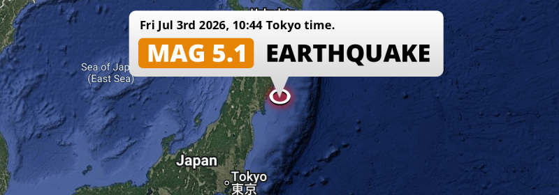
A significant Magnitude 5.1 earthquake struck in the North Pacific Ocean 131 kilometer from Sendai, Japan in the morning of Friday July 3rd, 2026.
Felt the earthquake? Share this article: 


Earthquake Summary
This earthquake hit under water in the North Pacific Ocean, 56 kilometers (35 mi) off the coast of Japan, 131 kilometer north-east of Sendai in Miyagi. The center of this earthquake had a quite shallow depth of 34 km. Shallow earthquakes usually have a larger impact than earthquakes deep in the earth.
| Date and Time: | Jul 3, 2026 10:44 (Tokyo Time) - Jul 3, 2026 01:44 Universal Time. |
|---|---|
| Location: | 131 km NE of Sendai, Miyagi, Japan. Coordinates 38°43'41"N 142°15'24"E. |
| Map: | 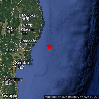 Map of area around epicenter. Click to open in Google Maps. |
| Magnitude: | MAG 5.1 Detected by 14 stations. Maximum Error Range ±0.083 . |
| Depth: | 34 km (21 mi) A quite shallow depth. |
| Tsunami Risk: | Low tsunami risk Earthquakes under MAG-6.5 do not usually cause tsunami's. Always stay cautious - More info here. |
Nearby towns and cities
This earthquake may have been felt in Japan . The closest significant population center near the earthquake is Ōfunato in Iwate, Japan. Ōfunato is located 60 kilometer (37 mi) south-east of the epicenter.
Major cities near this earthquake: Sendai is located 131 km to the southwest. Niigata is located 299 km to the west. Morioka is located 144 km to the northwest.
The table below provides an overview of all places in proximity of today's earthquake.
Overview of nearby places
| Distance | Place |
|---|---|
| 60 km (37 mi) NW from epicenter |
Ōfunato Iwate, Japan. |
| 70 km (43 mi) NW from epicenter |
Kamaishi Iwate, Japan. |
| 86 km (53 mi) N from epicenter |
Yamada Iwate, Japan. |
| 90 km (56 mi) SW from epicenter |
Ishinomaki Miyagi, Japan. |
| 91 km (57 mi) NW from epicenter |
Tōno Iwate, Japan. |
| 97 km (60 mi) W from epicenter |
Yamoto Miyagi, Japan. |
| 100 km (62 mi) W from epicenter |
Wakuya Miyagi, Japan. |
| 100 km (62 mi) W from epicenter |
Ichinoseki Iwate, Japan. |
| 106 km (66 mi) N from epicenter |
Miyako Iwate, Japan. |
| 107 km (66 mi) NW from epicenter |
Mizusawa Iwate, Japan. |
| 107 km (66 mi) W from epicenter |
Kogota Miyagi, Japan. |
| 111 km (69 mi) W from epicenter |
Matsushima Miyagi, Japan. |
| 112 km (70 mi) NW from epicenter |
Kanegasaki Iwate, Japan. |
| 114 km (71 mi) W from epicenter |
Furukawa Miyagi, Japan. |
| 116 km (72 mi) NW from epicenter |
Kitakami Iwate, Japan. |
| 116 km (72 mi) SW from epicenter |
Shiogama Miyagi, Japan. |
| 120 km (75 mi) W from epicenter |
Rifu Miyagi, Japan. |
| 122 km (76 mi) NW from epicenter |
Hanamaki Iwate, Japan. |
| 125 km (78 mi) W from epicenter |
Tomiya Miyagi, Japan. |
| 131 km (81 mi) SW from epicenter |
Sendai Miyagi, Japan. |
| 140 km (87 mi) SW from epicenter |
Iwanuma Miyagi, Japan. |
| 144 km (89 mi) NW from epicenter |
Morioka Iwate, Japan. |
| 145 km (90 mi) SW from epicenter |
Watari Miyagi, Japan. |
| 153 km (95 mi) SW from epicenter |
Ōkawara Miyagi, Japan. |
| 153 km (95 mi) NW from epicenter |
Shizukuishi Iwate, Japan. |
| 154 km (96 mi) SW from epicenter |
Kakuda Miyagi, Japan. |
| 160 km (99 mi) W from epicenter |
Yuzawa Akita, Japan. |
| 161 km (100 mi) NW from epicenter |
Yokote Akita, Japan. |
| 162 km (101 mi) W from epicenter |
Obanazawa Yamagata, Japan. |
| 164 km (102 mi) SW from epicenter |
Shiroishi Miyagi, Japan. |
| 165 km (103 mi) W from epicenter |
Higashine Yamagata, Japan. |
| 169 km (105 mi) W from epicenter |
Tendō Yamagata, Japan. |
| 170 km (106 mi) W from epicenter |
Shinjō Yamagata, Japan. |
| 173 km (107 mi) NW from epicenter |
Ōmagari Akita, Japan. |
| 173 km (107 mi) W from epicenter |
Yamagata Yamagata, Japan. |
| 177 km (110 mi) W from epicenter |
Sagae Yamagata, Japan. |
| 177 km (110 mi) SW from epicenter |
Namie Fukushima, Japan. |
| 180 km (112 mi) SW from epicenter |
Hobaramachi Fukushima, Japan. |
| 184 km (114 mi) W from epicenter |
Kaminoyama Yamagata, Japan. |
| 190 km (118 mi) SW from epicenter |
Fukushima Fukushima, Japan. |
| 207 km (129 mi) N from epicenter |
Hachinohe Aomori, Japan. |
| 208 km (129 mi) SW from epicenter |
Yonezawa Yamagata, Japan. |
| 209 km (130 mi) W from epicenter |
Sakata Yamagata, Japan. |
| 211 km (131 mi) W from epicenter |
Tsuruoka Yamagata, Japan. |
| 215 km (134 mi) NW from epicenter |
Akita Akita, Japan. |
| 221 km (137 mi) SW from epicenter |
Kōriyama Fukushima, Japan. |
| 222 km (138 mi) SW from epicenter |
Iwaki Fukushima, Japan. |
| 258 km (160 mi) NW from epicenter |
Hirosaki Aomori, Japan. |
| 266 km (165 mi) NW from epicenter |
Aomori Aomori, Japan. |
| 274 km (170 mi) SW from epicenter |
Nasushiobara Tochigi, Japan. |
| 276 km (171 mi) SW from epicenter |
Hitachi Ibaraki, Japan. |
| 299 km (186 mi) W from epicenter |
Niigata Niigata, Japan. |
Aftershocks detected
Before this earthquake struck, 1 smaller foreshock occurred. A 4.2 magnitude earthquake hit 5 hrs earlier nearby.
Overview of foreshocks and aftershocks
| Classification | Magnitude | When | Where |
|---|---|---|---|
| Foreshock | M 4.2 |
5 hrs earlier Jul 3, 2026 05:24 (Tokyo Time) | 37 km (23 mi) NW from Main Shock. |
| Main Shock This Earthquake |
M 5.1 |
Jul 3, 2026 10:44 (Tokyo Time) | - |
More earthquakes coming?
Aftershocks are usually at least 1 order of magnitude less strong than main shocks. The more time passes, the smaller the chance and likely strength of any potential aftershocks.
The chance that a significant earthquake like this one is followed by an even larger earthquake is not so large. On average, scientists estimate a 94% chance that a major earthquake will not be followed by an even larger one. It is still adviced to be aware of this risk
Read: How to Stay Safe during an Earthquake (cdc.gov).Earthquakes like this happen often in the region
Earthquakes of this strength are very common in the region. This is the strongest earthquake to hit since July 1st, 2026, when a 6 magnitude earthquake hit 165 km (103 mi) further north. An even stronger magnitude 7.6 earthquake struck on December 8th, 2025.
In total, 178 earthquakes with a magnitude of 5.1 or higher have been registered within 300km (186 mi) of this epicenter in the past 10 years. This comes down to an average of once every 21 days.
Low tsunami risk
Based on early data it appears this earthquake was not strong enough (lower than MAG-6.5) to be likely to cause destructive tsunami's. However this earthquake appeared to have hit at a shallow depth under sea, so stay cautious and monitor advice from local authorities.
Tsunami Risk Factors
| Factor | Under Sea? | MAG-6.5 or stronger? | Shallow depth? |
|---|---|---|---|
| Explanation | Almost all tsunami's are caused by earthquakes with their epicenter under sea or very near the sea. However stay cautious in coastal areas as earthquakes on land may cause landslides into sea, potentially still causing a local tsunami. | Under MAG 6.5: Very unlikely to cause a tsunami. MAG 6.5 to 7.5: Destructive tsunami's do occur, but are uncommon. Likely to observe small sea level changes. MAG 7.6+: Earthquakes with these magnitudes might produce destructive tsunami's. |
Most destructive tsunami's are caused by shallow earthquakes with a depth between 0 and 100km under the surface of the earth. Deeper tsunami's are unlikely to displace to ocean floor. |
| This Earthquake | This earthquake appears to have struck under the sea. | Not this earthquake. This earthquake had a magnitude of 5.1. Earthquakes of this strength are unlikely to trigger a tsunami. |
This earthquake occurred at a depth of of 34 km (21 mi). Earthquakes this shallow could trigger a tsunami. |
Sources
Last updated 26/07/26 03:48 (). This article is automatically generated based on available data. We keep checking multiple sources for additional information. This article gets updated as new details on this earthquake become available.
- US Geographic Society (USGS): Earthquake us6000t9qx
- European-Mediterranean Seismological Centre (EMSC): Earthquake 20260703_0000024
- Geonames.org: World Cities Database
- Google Maps: Static API
- Earthquakelist.org: Historic Earthquakes Database
Share this article:
