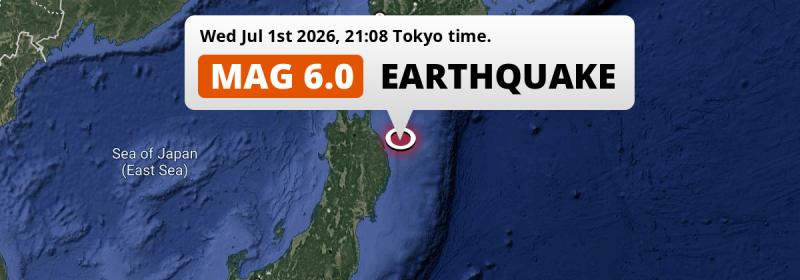
In the evening of Wednesday July 1st, 2026, a strong M6.0 earthquake hit in the North Pacific Ocean 84 kilometer from Hachinohe, Japan. Around 4.4 million people have been exposed to shaking.
Felt the earthquake? Share this article: 


Earthquake Summary
This earthquake hit under water in the North Pacific Ocean, 53 kilometers (33 mi) off the coast of Japan, 84 kilometer south-east of Hachinohe in Aomori. The center of this earthquake had a quite shallow depth of 44 km. Shallow earthquakes usually have a larger impact than earthquakes deep in the earth.
| Date and Time: | Jul 1, 2026 21:08 (Tokyo Time) - Jul 1, 2026 12:08 Universal Time. |
|---|---|
| Location: | 84 km SE of Hachinohe, Aomori, Japan. Coordinates 40°9'49"N 142°23'34"E. |
| Map: | 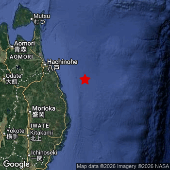 Map of area around epicenter. Click to open in Google Maps. |
| Magnitude: | MAG 6.0 Detected by 29 stations. Maximum Error Range ±0.058 . |
| Depth: | 44 km (27 mi) A quite shallow depth. |
| Max. Intensity: | V
Moderate On the Modified Mercalli Scale. |
| Tsunami Risk: | Low tsunami risk Earthquakes under MAG-6.5 do not usually cause tsunami's. Always stay cautious - More info here. |
Minimal impact predicted
Based on scientific estimates by the US Geographic Survey (USGS), the risk of high fatalities for this earthquake is classified at level GREEN (low). They expect an 90% likelyhood of between 0 and 1 fatalities.
The USGS classifies the economic impact of this earthquake at level GREEN (low). They expect an 90% likelyhood of between 0 and 1 million US Dollars in economic damage and impact.
Roughly 4.4 million people exposed to shaking
An estimated 4.4 million have been exposed to shaking (An MMI or Modified Mercalli Intensity level II or higher) as a result of this earthquake according scientific estimates published by the USGS.
The highest earthquake impact level for this earthquake is IV, which corresponds with light shaking and likely no damage. Roughly 1,514,000 people are expected to be exposed to this level. The majority of people (roughly 2.9 million) live in an area exposed to level III, where weak shaking and probably no damage is expected. All exposure to shaking was within the borders of Japan .
| People | MMI Level | Shaking | Damage |
|---|---|---|---|
| 0 | I |
Not noticable | None |
| 150 | II |
Very weak | None |
| 2,875,000 | III |
Weak | Probably none |
| 1,514,000 | IV |
Light | Likely none |
| 0 | V |
Moderate | Very light |
| 0 | VI |
Strong | Light |
| 0 | VII |
Very Strong | Moderate |
| 0 | VIII |
Severe | Moderate to heavy |
| 0 | IX |
Violent | Heavy |
| 0 | X |
Extreme | Very heavy |
Nearby towns and cities
This earthquake may have been felt in Japan . The closest significant population center near the earthquake is Miyako in Iwate, Japan. Miyako is located 69 kilometer (43 mi) north-east of the epicenter. The intensity of shaking and damage in Miyako is estimated to be around level IV on the Modified Mercalli Intensity scale (light shaking, likely no damage).
Multiple major population centers exist within 300km of the earthquake that struck today. Sapporo is located 334 km to the north (intensity unknown, possibly low). Sendai is located 249 km to the southwest (intensity unknown, possibly low). Hachinohe is located 84 km to the northwest and experienced an intensity of IV (light shaking, likely no damage).
An overview of nearby towns and cities is available in the overview below. If places don't have intensity data available, it likely means the experienced impact in those places was fairly small.
Overview of nearby places
| Distance | Place | Intensity (MMI) |
|---|---|---|
| 69 km (43 mi) SW from epicenter |
Miyako Iwate, Japan. |
IV
Light |
| 84 km (52 mi) NW from epicenter |
Hachinohe Aomori, Japan. |
IV
Light |
| 86 km (53 mi) SW from epicenter |
Yamada Iwate, Japan. |
IV
Light |
| 103 km (64 mi) NW from epicenter |
Misawa Aomori, Japan. |
IV
Light |
| 108 km (67 mi) SW from epicenter |
Kamaishi Iwate, Japan. |
III
Weak |
| 118 km (73 mi) SW from epicenter |
Morioka Iwate, Japan. |
IV
Light |
| 119 km (74 mi) SW from epicenter |
Tōno Iwate, Japan. |
IV
Light |
| 131 km (81 mi) SW from epicenter |
Shizukuishi Iwate, Japan. |
III
Weak |
| 135 km (84 mi) SW from epicenter |
Ōfunato Iwate, Japan. |
IV
Light |
| 136 km (85 mi) W from epicenter |
Hanawa Akita, Japan. |
III
Weak |
| 139 km (86 mi) SW from epicenter |
Hanamaki Iwate, Japan. |
III
Weak |
| 147 km (91 mi) SW from epicenter |
Kitakami Iwate, Japan. |
III
Weak |
| 153 km (95 mi) SW from epicenter |
Kanegasaki Iwate, Japan. |
IV
Light |
| 156 km (97 mi) W from epicenter |
Ōdate Akita, Japan. |
III
Weak |
| 157 km (98 mi) SW from epicenter |
Mizusawa Iwate, Japan. |
III
Weak |
| 158 km (98 mi) NW from epicenter |
Aomori Aomori, Japan. |
IV
Light |
| 160 km (99 mi) NW from epicenter |
Mutsu Aomori, Japan. |
IV
Light |
| 162 km (101 mi) W from epicenter |
Kuroishi Aomori, Japan. |
III
Weak |
| 164 km (102 mi) W from epicenter |
Namioka Aomori, Japan. |
III
Weak |
| 170 km (106 mi) W from epicenter |
Hirosaki Aomori, Japan. |
III
Weak |
| 172 km (107 mi) W from epicenter |
Takanosu Akita, Japan. |
III
Weak |
| 176 km (109 mi) SW from epicenter |
Ichinoseki Iwate, Japan. |
III
Weak |
| 180 km (112 mi) NW from epicenter |
Goshogawara Aomori, Japan. |
IV
Light |
| 181 km (112 mi) SW from epicenter |
Ōmagari Akita, Japan. |
IV
Light |
| 184 km (114 mi) SW from epicenter |
Yokote Akita, Japan. |
III
Weak |
| 185 km (115 mi) NW from epicenter |
Shimokizukuri Aomori, Japan. |
IV
Light |
| 196 km (122 mi) SW from epicenter |
Yuzawa Akita, Japan. |
III
Weak |
| 200 km (124 mi) W from epicenter |
Akita Akita, Japan. |
III
Weak |
| 201 km (125 mi) W from epicenter |
Noshiro Akita, Japan. |
|
| 216 km (134 mi) SW from epicenter |
Furukawa Miyagi, Japan. |
III
Weak |
| 216 km (134 mi) SW from epicenter |
Ishinomaki Miyagi, Japan. |
III
Weak |
| 227 km (141 mi) NW from epicenter |
Hakodate Hokkaido, Japan. |
III
Weak |
| 235 km (146 mi) NW from epicenter |
Kamiiso Hokkaido, Japan. |
III
Weak |
| 236 km (147 mi) SW from epicenter |
Shiogama Miyagi, Japan. |
|
| 236 km (147 mi) SW from epicenter |
Tomiya Miyagi, Japan. |
III
Weak |
| 238 km (148 mi) SW from epicenter |
Shinjō Yamagata, Japan. |
III
Weak |
| 249 km (155 mi) SW from epicenter |
Sendai Miyagi, Japan. |
|
| 257 km (160 mi) SW from epicenter |
Higashine Yamagata, Japan. |
III
Weak |
| 258 km (160 mi) SW from epicenter |
Sakata Yamagata, Japan. |
|
| 266 km (165 mi) SW from epicenter |
Tendō Yamagata, Japan. |
III
Weak |
| 267 km (166 mi) NW from epicenter |
Muroran Hokkaido, Japan. |
|
| 273 km (170 mi) SW from epicenter |
Tsuruoka Yamagata, Japan. |
|
| 277 km (172 mi) SW from epicenter |
Yamagata Yamagata, Japan. |
|
| 283 km (176 mi) N from epicenter |
Tomakomai Hokkaido, Japan. |
|
| 314 km (195 mi) N from epicenter |
Obihiro Hokkaido, Japan. |
|
| 316 km (196 mi) SW from epicenter |
Fukushima Fukushima, Japan. |
|
| 334 km (208 mi) N from epicenter |
Sapporo Hokkaido, Japan. |
|
| 353 km (219 mi) NE from epicenter |
Kushiro Hokkaido, Japan. |
|
| 353 km (219 mi) SW from epicenter |
Kōriyama Fukushima, Japan. |
|
| 370 km (230 mi) S from epicenter |
Iwaki Fukushima, Japan. |
|
| 387 km (240 mi) SW from epicenter |
Niigata Niigata, Japan. |
Earthquake Intensity Map
The graph below overlays a map of the region around the epicenter with earthquake intensity data provided by the US Geographic Survey. The highest intensity level detected for this earthquake is IV.

Shaking reported by 9 people
People that feel an earthquake may report their experience to the US Geographic Survey. Currently, 9 people have reported shaking in 6 places, all within Japan.We keep updating this article as more ground reports become available. You may report that you felt this earthquake here.
Places with most reports:
- Misawa, Aomori, Japan: 2 people.
- Sendai, Miyagi, Japan: 2 people.
- Aomori, Aomori, Japan: 2 people.
- Hachinohe, Aomori, Japan: 1 person.
- Hakodate, Hokkaido, Japan: 1 person.
- Omagari, Akita, Japan: 1 person.
5 Aftershocks detected
This main shock was followed by 5 smaller aftershocks. At a distance of 21 km (13 mi) north of this earthquake, an aftershock struck 4 hrs later. It measured a magnitude of 4.9
In the days before this main shock, 5 smaller foreshocks were detected. Nearby this earthquake a foreshock struck 22 hrs earlier. It measured a magnitude of 4.8
Overview of foreshocks and aftershocks
| Classification | Magnitude | When | Where |
|---|---|---|---|
| Foreshock | M 4.2 |
3 days earlier Jun 28, 2026 23:49 (Tokyo Time) | 22 km (13 mi) NW from Main Shock. |
| Foreshock | M 4.4 |
3 days earlier Jun 29, 2026 08:11 (Tokyo Time) | 70 km (43 mi) NW from Main Shock. |
| Foreshock | M 3.4 |
1 day earlier Jun 30, 2026 09:38 (Tokyo Time) | 29 km (18 mi) S from Main Shock. |
| Foreshock | M 3.6 |
1 day earlier Jun 30, 2026 12:24 (Tokyo Time) | 31 km (19 mi) NW from Main Shock. |
| Foreshock | M 4.8 |
22 hrs earlier Jun 30, 2026 23:02 (Tokyo Time) | 2.7 km (1.7 mi) W from Main Shock. |
| Main Shock This Earthquake |
M 6.0 |
Jul 1, 2026 21:08 (Tokyo Time) | - |
| Aftershock | M 4.2 |
3 hrs later Jul 1, 2026 23:52 (Tokyo Time) | 48 km (30 mi) NW from Main Shock. |
| Aftershock | M 4.9 |
4 hrs later Jul 2, 2026 01:15 (Tokyo Time) | 21 km (13 mi) N from Main Shock. |
| Aftershock | M 4.3 |
1 day later Jul 3, 2026 07:05 (Tokyo Time) | 61 km (38 mi) NW from Main Shock. |
| Aftershock | M 4.1 |
2 days later Jul 3, 2026 23:37 (Tokyo Time) | 38 km (23 mi) NW from Main Shock. |
| Aftershock | M 3.8 |
3 days later Jul 4, 2026 10:17 (Tokyo Time) | 9 km (5 mi) NW from Main Shock. |
More earthquakes coming?
Earthquakes can create aftershocks. These are generally at least 1 magnitude lower than any main shock, and as time passes the chance and strength of aftershocks decreases.
In only six percent of cases, significant earthquakes are followed by a larger main shock, making the current earthquake a foreshock. While the chance of this happening is not so large, it is adviced to maintain cautiousness in the hours and days following a major earthquake.
Read: How to Stay Safe during an Earthquake (cdc.gov).Earthquakes like this happen often in the region
Earthquakes of this strength are very common in the region. This is the strongest earthquake to hit since June 24th, 2026, when a 6.9 magnitude earthquake hit 22 km (14 mi) further northwest. An even stronger magnitude 7.6 earthquake struck on December 8th, 2025.
In total, 32 earthquakes with a magnitude of 6 or higher have been registered within 300km (186 mi) of this epicenter in the past 10 years. This comes down to an average of once every 4 months.
Low tsunami risk
Based on early data it appears this earthquake was not strong enough (lower than MAG-6.5) to be likely to cause destructive tsunami's. However this earthquake appeared to have hit at a shallow depth under sea, so stay cautious and monitor advice from local authorities.
Tsunami Risk Factors
| Factor | Under Sea? | MAG-6.5 or stronger? | Shallow depth? |
|---|---|---|---|
| Explanation | Almost all tsunami's are caused by earthquakes with their epicenter under sea or very near the sea. However stay cautious in coastal areas as earthquakes on land may cause landslides into sea, potentially still causing a local tsunami. | Under MAG 6.5: Very unlikely to cause a tsunami. MAG 6.5 to 7.5: Destructive tsunami's do occur, but are uncommon. Likely to observe small sea level changes. MAG 7.6+: Earthquakes with these magnitudes might produce destructive tsunami's. |
Most destructive tsunami's are caused by shallow earthquakes with a depth between 0 and 100km under the surface of the earth. Deeper tsunami's are unlikely to displace to ocean floor. |
| This Earthquake | This earthquake appears to have struck under the sea. | Not this earthquake. This earthquake had a magnitude of 6. Earthquakes of this strength are unlikely to trigger a tsunami. |
This earthquake occurred at a depth of of 44 km (27 mi). Earthquakes this shallow could trigger a tsunami. |
Sources
Last updated 21/07/26 13:38 (). This article contains currently available information about the earthquake and is automatically composed. We continue to update this article up to a few days after the earthquake occurred.
- US Geographic Society (USGS): Earthquake us6000t9ej
- European-Mediterranean Seismological Centre (EMSC): Earthquake 20260701_0000193
- Geonames.org: World Cities Database
- Google Maps: Static API
- Earthquakelist.org: Historic Earthquakes Database
Share this article:
