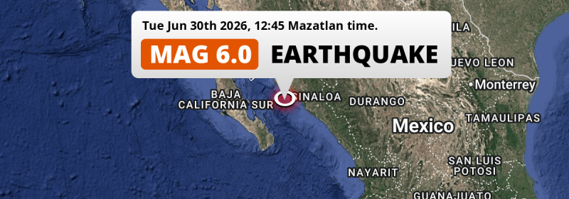
A shallow and strong MAG-6.0 earthquake struck in the Gulf Of California 94 kilometer from Guasave, Mexico in the early afternoon of Tuesday June 30th, 2026. Roughly 3 million people may have felt this earthquake.
Felt the earthquake? Share this article: 


Earthquake Summary
This earthquake hit under water in the Gulf Of California, 66 kilometers (41 mi) off the coast of Mexico, 94 kilometer southwest of Guasave in Sinaloa. The center of this earthquake had a very shallow depth of 10 km. Shallow earthquakes usually have a larger impact than earthquakes deep in the earth.
| Date and Time: | Jun 30, 2026 12:45 (Mazatlan Time) - Jun 30, 2026 19:45 Universal Time. |
|---|---|
| Location: | 94 km SW of Guasave, Sinaloa, Mexico. Coordinates 24°48'32"N 108°53'25"W. |
| Map: | 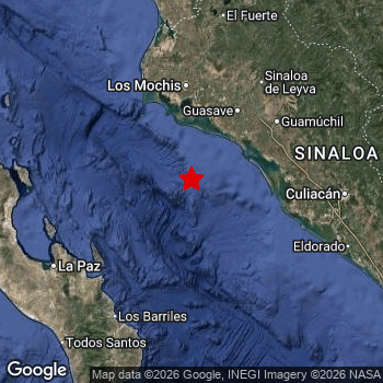 Map of area around epicenter. Click to open in Google Maps. |
| Magnitude: | MAG 6.0 Detected by 68 stations. Maximum Error Range ±0.038 . |
| Depth: | 10 km (6 mi) A very shallow depth. |
| Max. Intensity: | V
Moderate On the Modified Mercalli Scale. |
| Tsunami Risk: | Low tsunami risk Earthquakes under MAG-6.5 do not usually cause tsunami's. Always stay cautious - More info here. |
Minimal impact predicted
Based on scientific estimates by the US Geographic Survey (USGS), the risk of high fatalities for this earthquake is classified at level GREEN (low). They expect an 90% likelyhood of between 0 and 1 fatalities.
The USGS classifies the economic impact of this earthquake at level GREEN (low). They expect an 90% likelyhood of between 0 and 1 million US Dollars in economic damage and impact.
Roughly 3 million people exposed to shaking
The USGS has published a report estimating the number of people exposed to this earthquake. Acoording to their analysis, roughly 3 million have been exposed to shaking at an MMI level of II or higher.
An estimated 9,530 people were exposed to level V. At this level, moderate shaking and very light damage can be expected. The majority of people (roughly 2.7 million) live in an area exposed to level IV, where light shaking and likely no damage is expected. All exposure to shaking was within the borders of Mexico .
| People | MMI Level | Shaking | Damage |
|---|---|---|---|
| 0 | I |
Not noticable | None |
| 0 | II |
Very weak | None |
| 365,100 | III |
Weak | Probably none |
| 2,658,000 | IV |
Light | Likely none |
| 9,530 | V |
Moderate | Very light |
| 0 | VI |
Strong | Light |
| 0 | VII |
Very Strong | Moderate |
| 0 | VIII |
Severe | Moderate to heavy |
| 0 | IX |
Violent | Heavy |
| 0 | X |
Extreme | Very heavy |
Nearby towns and cities
This earthquake may have been felt in Mexico . The closest significant population center near the earthquake is Guasave in Sinaloa, Mexico. Guasave is located 94 kilometer (58 mi) southwest of the epicenter. The intensity of shaking and damage in Guasave is estimated to be around level IV on the Modified Mercalli Intensity scale (light shaking, likely no damage).
Multiple large cities are in proximity of today's earthquake. Culiacán is located 152 km to the east and experienced an intensity of IV (light shaking, likely no damage). Los Mochis is located 110 km to the north and experienced an intensity of IV (light shaking, likely no damage). La Paz is located 161 km to the southwest and experienced an intensity of IV (light shaking, likely no damage).
A complete list of nearby places is included below. Estimated intensity data (MMI) sourced from a shake-map published by the US Geographic Survey is shown where available (cities without data probably experienced little impact).
Overview of nearby places
| Distance | Place | Intensity (MMI) |
|---|---|---|
| 94 km (58 mi) NE from epicenter |
Guasave Sinaloa, Mexico. |
IV
Light |
| 98 km (61 mi) N from epicenter |
Leyva Solano Sinaloa, Mexico. |
IV
Light |
| 106 km (66 mi) N from epicenter |
Juan José Ríos Sinaloa, Mexico. |
IV
Light |
| 109 km (68 mi) NE from epicenter |
Guamúchil Sinaloa, Mexico. |
IV
Light |
| 110 km (68 mi) N from epicenter |
Los Mochis Sinaloa, Mexico. |
IV
Light |
| 120 km (75 mi) E from epicenter |
Navolato Sinaloa, Mexico. |
IV
Light |
| 137 km (85 mi) E from epicenter |
Licenciado Benito Juárez (Campo Gobierno) Sinaloa, Mexico. |
IV
Light |
| 137 km (85 mi) E from epicenter |
Villa Juárez Sinaloa, Mexico. |
IV
Light |
| 152 km (94 mi) E from epicenter |
Culiacán Sinaloa, Mexico. |
IV
Light |
| 154 km (96 mi) E from epicenter |
Villa de Costa Rica Sinaloa, Mexico. |
IV
Light |
| 161 km (100 mi) SW from epicenter |
La Paz Baja California Sur, Mexico. |
IV
Light |
| 211 km (131 mi) S from epicenter |
San José del Cabo Baja California Sur, Mexico. |
III
Weak |
| 225 km (140 mi) SE from epicenter |
La Cruz Sinaloa, Mexico. |
III
Weak |
| 236 km (147 mi) SW from epicenter |
Colonia del Sol Baja California Sur, Mexico. |
|
| 237 km (147 mi) SW from epicenter |
Cabo San Lucas Baja California Sur, Mexico. |
|
| 237 km (147 mi) N from epicenter |
Huatabampo Sonora, Mexico. |
|
| 257 km (160 mi) N from epicenter |
Navojoa Sonora, Mexico. |
|
| 281 km (175 mi) W from epicenter |
Ciudad Constitución Baja California Sur, Mexico. |
|
| 307 km (191 mi) SE from epicenter |
Mazatlán Sinaloa, Mexico. |
|
| 316 km (196 mi) N from epicenter |
Ciudad Obregón Sonora, Mexico. |
|
| 325 km (202 mi) N from epicenter |
Esperanza Sonora, Mexico. |
|
| 351 km (218 mi) E from epicenter |
Santiago Papasquiaro Durango, Mexico. |
|
| 369 km (229 mi) SE from epicenter |
El Rosario Sinaloa, Mexico. |
|
| 375 km (233 mi) E from epicenter |
El Salto Durango, Mexico. |
|
| 385 km (239 mi) SE from epicenter |
Escuinapa Sinaloa, Mexico. |
|
| 390 km (242 mi) SE from epicenter |
Pueblo Nuevo Durango, Mexico. |
|
| 400 km (249 mi) NW from epicenter |
Empalme Sonora, Mexico. |
|
| 400 km (249 mi) NW from epicenter |
Heroica Guaymas Sonora, Mexico. |
|
| 400 km (249 mi) NE from epicenter |
Parral Chihuahua, Mexico. |
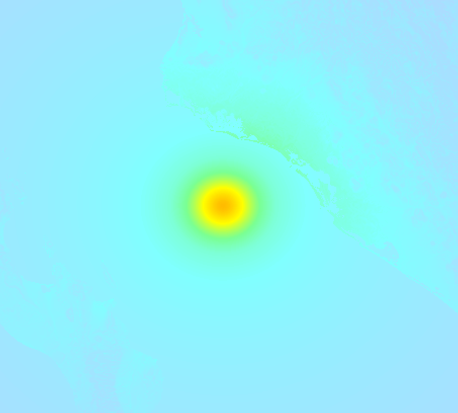
Earthquake Intensity Map
The maximum intensity (MMI Scale) caused by this earthquake is V. The map below shows in which areas this earthquake was the most and least impactful. It is based on data from the US Geographic Survey.
Shaking reported by 13 people
People that feel an earthquake may report their experience to the US Geographic Survey. Currently, 13 people have reported shaking in 5 places, all within Mexico.We keep updating this article as more ground reports become available. You may report that you felt this earthquake here.
Places with most reports:
- Los Mochis, Sinaloa, Mexico: 8 people.
- Guasave, Sinaloa, Mexico: 2 people.
- Culiacán, Sinaloa, Mexico: 1 person.
- La Palma, Sinaloa, Mexico: 1 person.
- Zapopan, Jalisco, Mexico: 1 person.
12 Aftershocks detected
After this earthquake struck, 12 smaller aftershocks occurred. Just 1 hr after this main shock, an earthquake measuring MAG-5.3 was detected 23 km (14 mi) southwest of this earthquake.
Overview of foreshocks and aftershocks
| Classification | Magnitude | When | Where |
|---|---|---|---|
| Main Shock This Earthquake |
M 6.0 |
Jun 30, 2026 12:45 (Mazatlan Time) | - |
| Aftershock | M 4.4 |
22 mins later Jun 30, 2026 13:08 (Mazatlan Time) | 54 km (34 mi) SW from Main Shock. |
| Aftershock | M 4.5 |
44 mins later Jun 30, 2026 13:29 (Mazatlan Time) | 20 km (12 mi) SW from Main Shock. |
| Aftershock | M 4.5 |
44 mins later Jun 30, 2026 13:29 (Mazatlan Time) | 53 km (33 mi) NW from Main Shock. |
| Aftershock | M 3.9 |
50 mins later Jun 30, 2026 13:35 (Mazatlan Time) | 38 km (24 mi) SW from Main Shock. |
| Aftershock | M 4.1 |
1 hr later Jun 30, 2026 13:51 (Mazatlan Time) | 38 km (23 mi) SW from Main Shock. |
| Aftershock | M 5.3 |
1 hr later Jun 30, 2026 14:01 (Mazatlan Time) | 23 km (14 mi) SW from Main Shock. |
| Aftershock | M 4.1 |
2 hrs later Jun 30, 2026 14:42 (Mazatlan Time) | 62 km (38 mi) S from Main Shock. |
| Aftershock | M 3.9 |
2 hrs later Jun 30, 2026 15:09 (Mazatlan Time) | 50 km (31 mi) SW from Main Shock. |
| Aftershock | M 4.1 |
3 hrs later Jun 30, 2026 15:36 (Mazatlan Time) | 48 km (30 mi) S from Main Shock. |
| Aftershock | M 4.1 |
14 hrs later Jul 1, 2026 03:14 (Mazatlan Time) | 37 km (23 mi) SW from Main Shock. |
| Aftershock | M 3.9 |
15 hrs later Jul 1, 2026 03:56 (Mazatlan Time) | 58 km (36 mi) SW from Main Shock. |
| Aftershock | M 4.2 |
16 hrs later Jul 1, 2026 04:32 (Mazatlan Time) | 42 km (26 mi) SW from Main Shock. |
More earthquakes coming?
The risk of aftershocks decreases rapidly over time. Usually, aftershocks are at least one order of magnitude lower than a main shock.
In only six percent of cases, significant earthquakes are followed by a larger main shock, making the current earthquake a foreshock. While the chance of this happening is not so large, it is adviced to maintain cautiousness in the hours and days following a major earthquake.
Read: How to Stay Safe during an Earthquake (cdc.gov).This is the strongest earthquake in 3 years
Earthquakes of this strength are not so common in the region, but it's not the first time. This is the strongest earthquake to hit since June 18th, 2023, when a 6.4 magnitude earthquake hit 184 km (114 mi) further south. That was also the heaviest earthquake to hit the region in the past 10 years.
In total, 2 earthquakes with a magnitude of 6 or higher have been registered within 300km (186 mi) of this epicenter in the past 10 years. This comes down to an average of once every 5 years.
Low tsunami risk
Based on early data it appears this earthquake was not strong enough (lower than MAG-6.5) to be likely to cause destructive tsunami's. However this earthquake appeared to have hit at a shallow depth under sea, so stay cautious and monitor advice from local authorities.
Tsunami Risk Factors
| Factor | Under Sea? | MAG-6.5 or stronger? | Shallow depth? |
|---|---|---|---|
| Explanation | Almost all tsunami's are caused by earthquakes with their epicenter under sea or very near the sea. However stay cautious in coastal areas as earthquakes on land may cause landslides into sea, potentially still causing a local tsunami. | Under MAG 6.5: Very unlikely to cause a tsunami. MAG 6.5 to 7.5: Destructive tsunami's do occur, but are uncommon. Likely to observe small sea level changes. MAG 7.6+: Earthquakes with these magnitudes might produce destructive tsunami's. |
Most destructive tsunami's are caused by shallow earthquakes with a depth between 0 and 100km under the surface of the earth. Deeper tsunami's are unlikely to displace to ocean floor. |
| This Earthquake | This earthquake appears to have struck under the sea. | Not this earthquake. This earthquake had a magnitude of 6. Earthquakes of this strength are unlikely to trigger a tsunami. |
This earthquake occurred at a depth of of 10 km (6 mi). Earthquakes this shallow could trigger a tsunami. |
Sources
Last updated 25/07/26 02:38 (). This article is automatically generated based on available data. We keep checking multiple sources for additional information. This article gets updated as new details on this earthquake become available.
- US Geographic Society (USGS): Earthquake us6000t99j
- European-Mediterranean Seismological Centre (EMSC): Earthquake 20260630_0000268
- Geonames.org: World Cities Database
- Google Maps: Static API
- Earthquakelist.org: Historic Earthquakes Database
Share this article:
