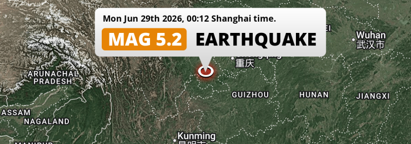
Just after midnight of Monday June 29th, 2026, a shallow and significant Magnitude 5.2 earthquake hit under land 20 kilometer from Yibin in China. The earthquake struck near a very densely populated region.
Felt the earthquake? Share this article: 


Earthquake Summary
The earthquake struck on land in China, 20 kilometer (12 mi) south-east of Yibin in Sichuan. The center of this earthquake had a very shallow depth of 10 km. Shallow earthquakes usually have a larger impact than earthquakes deep in the earth.
| Date and Time: | Jun 29, 2026 00:12 (Shanghai Time) - Jun 28, 2026 16:12 Universal Time. |
|---|---|
| Location: | 20 km SE of Yibin, Sichuan, China. Coordinates 28°38'29"N 104°47'59"E. |
| Map: | 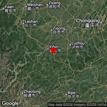 Map of area around epicenter. Click to open in Google Maps. |
| Magnitude: | MAG 5.2 Detected by 35 stations. Maximum Error Range ±0.052 . |
| Depth: | 10 km (6 mi) A very shallow depth. |
| Tsunami Risk: | Tsunami very unlikely While this was a shallow earthquake, it appears to have occurred under land with a magnitude not strong enough to cause tsunami's. Always stay cautious - More info here. |
Nearby towns and cities
This earthquake may have been felt in China . The closest significant population center near the earthquake is Changning in Sichuan, China. Changning is located 14 kilometer (9 mi) northwest of the epicenter.
Major cities near this earthquake: Chengdu is located 236 km to the north. Yibin is located 20 km to the northwest. Chongqing is located 199 km to the north-east.
The table below provides an overview of all places in proximity of today's earthquake.
Overview of nearby places
| Distance | Place |
|---|---|
| 14 km (9 mi) SE from epicenter |
Changning Sichuan, China. |
| 20 km (12 mi) NW from epicenter |
Yibin Sichuan, China. |
| 21 km (13 mi) NE from epicenter |
Luolong Sichuan, China. |
| 22 km (14 mi) S from epicenter |
Xunchang Sichuan, China. |
| 25 km (16 mi) W from epicenter |
Baixi Sichuan, China. |
| 28 km (17 mi) NE from epicenter |
Nanxi Sichuan, China. |
| 28 km (17 mi) E from epicenter |
Jiang’an Sichuan, China. |
| 36 km (22 mi) SW from epicenter |
Wenjiang Sichuan, China. |
| 36 km (22 mi) SW from epicenter |
Qingfu Sichuan, China. |
| 39 km (24 mi) W from epicenter |
Xiangjiaba Yunnan, China. |
| 45 km (28 mi) SE from epicenter |
Bowangshan Sichuan, China. |
| 49 km (30 mi) SW from epicenter |
Shuanglong Sichuan, China. |
| 54 km (34 mi) N from epicenter |
Baihua Sichuan, China. |
| 56 km (35 mi) E from epicenter |
Huguo Sichuan, China. |
| 56 km (35 mi) SE from epicenter |
Gusong Sichuan, China. |
| 57 km (35 mi) N from epicenter |
Kongtan Sichuan, China. |
| 57 km (35 mi) E from epicenter |
Naxi Sichuan, China. |
| 59 km (37 mi) SW from epicenter |
Junlian Sichuan, China. |
| 61 km (38 mi) NW from epicenter |
Juexi Sichuan, China. |
| 64 km (40 mi) S from epicenter |
Xunsi Sichuan, China. |
| 64 km (40 mi) NW from epicenter |
Guanyin Sichuan, China. |
| 67 km (42 mi) NE from epicenter |
Luzhou Sichuan, China. |
| 78 km (48 mi) N from epicenter |
Zigong Sichuan, China. |
| 79 km (49 mi) NE from epicenter |
Fuji Sichuan, China. |
| 81 km (50 mi) SE from epicenter |
Xuyong Sichuan, China. |
| 90 km (56 mi) NE from epicenter |
Taifu Sichuan, China. |
| 96 km (60 mi) NE from epicenter |
Yunjin Sichuan, China. |
| 98 km (61 mi) NE from epicenter |
Xuantan Sichuan, China. |
| 103 km (64 mi) E from epicenter |
Hejiang Sichuan, China. |
| 108 km (67 mi) N from epicenter |
Neijiang Sichuan, China. |
| 112 km (70 mi) NW from epicenter |
Luocheng Sichuan, China. |
| 116 km (72 mi) E from epicenter |
Shima Chongqing, China. |
| 119 km (74 mi) SE from epicenter |
Gulin Sichuan, China. |
| 133 km (83 mi) NE from epicenter |
Yongchuan Chongqing, China. |
| 137 km (85 mi) E from epicenter |
Baisha Chongqing, China. |
| 139 km (86 mi) NE from epicenter |
Longshui Chongqing, China. |
| 144 km (89 mi) NW from epicenter |
Leshan Sichuan, China. |
| 156 km (97 mi) S from epicenter |
Bijie Guizhou, China. |
| 158 km (98 mi) NE from epicenter |
Jijiang Chongqing, China. |
| 165 km (103 mi) N from epicenter |
Ziyang Sichuan, China. |
| 174 km (108 mi) NE from epicenter |
Bishan Chongqing, China. |
| 182 km (113 mi) SW from epicenter |
Zhaotong Yunnan, China. |
| 182 km (113 mi) NW from epicenter |
Meishan Sichuan, China. |
| 188 km (117 mi) NE from epicenter |
Banan Chongqing, China. |
| 199 km (124 mi) NE from epicenter |
Chongqing Chongqing, China. |
| 221 km (137 mi) N from epicenter |
Suining Sichuan, China. |
| 228 km (142 mi) S from epicenter |
Liupanshui Guizhou, China. |
| 232 km (144 mi) SE from epicenter |
Zunyi Guizhou, China. |
| 236 km (147 mi) N from epicenter |
Chengdu Sichuan, China. |
| 270 km (168 mi) NE from epicenter |
Nanchong Sichuan, China. |
| 270 km (168 mi) NE from epicenter |
Guang’an Sichuan, China. |
Shaking reported by 18 people
People that feel an earthquake may report their experience to the US Geographic Survey. Currently, 18 people have reported shaking in 8 places, all within China.We keep updating this article as more ground reports become available. You may report that you felt this earthquake here.
Places with most reports:
- Chengdu, Sichuan, China: 6 people.
- Chongqing, Chongqing, China: 3 people.
- Luzhou, Sichuan, China: 2 people.
- Huayang, Sichuan, China: 2 people.
- Leshan, Sichuan, China: 2 people.
- Xunchang, Sichuan, China: 1 person.
- Zigong, Sichuan, China: 1 person.
- Yibin, Sichuan, China: 1 person.
Risk of aftershocks?
We monitor for foreshocks or aftershocks that have a magnitude of 2.5+ and occur within 100km (62 mi) of the epicenter of this earthquake. So far no such earthquakes have been detected.
The risk of aftershocks decreases rapidly over time. Usually, aftershocks are at least one order of magnitude lower than a main shock.
In only six percent of cases, significant earthquakes are followed by a larger main shock, making the current earthquake a foreshock. While the chance of this happening is not so large, it is adviced to maintain cautiousness in the hours and days following a major earthquake.
Read: How to Stay Safe during an Earthquake (cdc.gov).This is the strongest earthquake in 3 years
Earthquakes of this strength occur quite regularly in the region. This is the strongest earthquake to hit since January 25th, 2023, when a 5.4 magnitude earthquake hit 298 km (185 mi) further northwest. An even stronger magnitude 6.6 earthquake struck on September 5th, 2022.
In total, 10 earthquakes with a magnitude of 5.2 or higher have been registered within 300km (186 mi) of this epicenter in the past 10 years. This comes down to an average of once every year.
Tsunami very unlikely
While MAG-6.5+ earthquakes may cause tsunami's, it appears that the epicenter of this earthquake hit under land. In addition, the reported depth is deeper than 100km, making the risk of a tsunami even less likely. However always stay cautious and monitor advice from local authorities.
Tsunami Risk Factors
| Factor | Under Sea? | MAG-6.5 or stronger? | Shallow depth? |
|---|---|---|---|
| Explanation | Almost all tsunami's are caused by earthquakes with their epicenter under sea or very near the sea. However stay cautious in coastal areas as earthquakes on land may cause landslides into sea, potentially still causing a local tsunami. | Under MAG 6.5: Very unlikely to cause a tsunami. MAG 6.5 to 7.5: Destructive tsunami's do occur, but are uncommon. Likely to observe small sea level changes. MAG 7.6+: Earthquakes with these magnitudes might produce destructive tsunami's. |
Most destructive tsunami's are caused by shallow earthquakes with a depth between 0 and 100km under the surface of the earth. Deeper tsunami's are unlikely to displace to ocean floor. |
| This Earthquake | Not this earthquake. This earthquake appears to have struck on land far from any coast. |
Not this earthquake. This earthquake had a magnitude of 5.2. Earthquakes of this strength are unlikely to trigger a tsunami. |
This earthquake occurred at a depth of of 10 km (6 mi). Earthquakes this shallow could trigger a tsunami. |
Sources
Last updated 21/07/26 01:28 (). This article is automatically generated based on available data. We keep checking multiple sources for additional information. This article gets updated as new details on this earthquake become available.
- US Geographic Society (USGS): Earthquake us6000t8u3
- European-Mediterranean Seismological Centre (EMSC): Earthquake 20260628_0000225
- Geonames.org: World Cities Database
- Google Maps: Static API
- Earthquakelist.org: Historic Earthquakes Database
Share this article:
