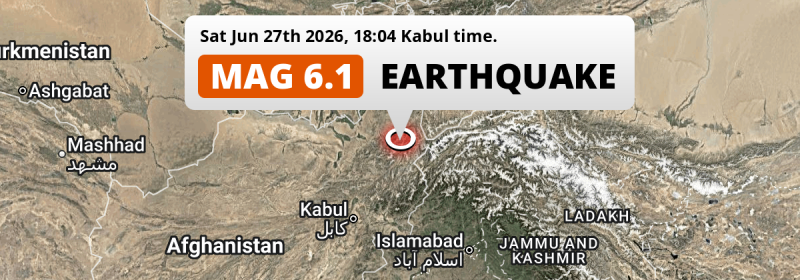
In the evening of Saturday June 27th, 2026, a strong M6.1 earthquake hit under land 72 kilometer from Fayzabad in Afghanistan. Shaking may have been felt by a total of 18 million people. Other nearby countries are Tajikistan and Pakistan.
Felt the earthquake? Share this article: 


Earthquake Summary
The earthquake struck on land in Afghanistan, 72 kilometer (45 mi) south of Fayzabad in Badakhshan. The center of this earthquake had an intermediate depth of 199 km.
| Date and Time: | Jun 27, 2026 06:04PM (Kabul Time) - Jun 27, 2026 13:34 Universal Time. |
|---|---|
| Location: | 72 km south of Fayzabad, Badakhshan, Afghanistan. Coordinates 36°28'50"N 70°43'51"E. |
| Map: | 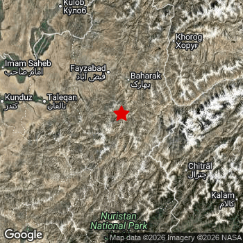 Map of area around epicenter. Click to open in Google Maps. |
| Magnitude: | MAG 6.1 Detected by 65 stations. Maximum Error Range ±0.038 . |
| Depth: | 199 km (124 mi) An intermediate depth. |
| Max. Intensity: | IV
Light On the Modified Mercalli Scale. |
| Tsunami Risk: | Tsunami very unlikely Tsunami's are usually caused by MAG-6.5+ earthquakes, less than 100km shallow, and with an epicenter under sea. Neither of this seems to be the case. Always stay cautious - More info here. |
Minimal impact predicted
Based on scientific estimates by the US Geographic Survey (USGS), the risk of high fatalities for this earthquake is classified at level GREEN (low). They expect an 90% likelyhood of between 0 and 1 fatalities.
The USGS classifies the economic impact of this earthquake at level GREEN (low). They expect an 90% likelyhood of between 0 and 1 million US Dollars in economic damage and impact.
Roughly 18 million people exposed to shaking
This earthquake may have been felt by around 18 million people. That is the expected population size of the area exposed to a level of shaking of II or higher on the Modified Mercalli scale according to the USGS.
Light shaking and likely no damage may have been experienced by an estimated 327,600 people. At IV, it is the highest MMI level this earthquake has caused. The majority of people (roughly 17 million) live in an area exposed to level III, where weak shaking and probably no damage is expected.
People in 3 countries have been exposed to shaking. In Afghanistan , around 8 million people, with impact levels up to IV (light shaking, likely no damage). Roughly 3.3 million people were exposed to shaking in Tajikistan . Roughly 6.7 million people were exposed to shaking in Pakistan .
| People | MMI Level | Shaking | Damage |
|---|---|---|---|
| 0 | I |
Not noticable | None |
| 562,500 | II |
Very weak | None |
| 16,970,000 | III |
Weak | Probably none |
| 327,600 | IV |
Light | Likely none |
| 0 | V |
Moderate | Very light |
| 0 | VI |
Strong | Light |
| 0 | VII |
Very Strong | Moderate |
| 0 | VIII |
Severe | Moderate to heavy |
| 0 | IX |
Violent | Heavy |
| 0 | X |
Extreme | Very heavy |
Nearby towns and cities
5 countries can be found within 300km of the epicenter of this earthquake: Afghanistan , Tajikistan and Pakistan . Futher away, this earthquake may also have been felt in Uzbekistan and Kyrgyzstan.
Fayzabad in Badakhshan, Afghanistan is the nearest significant place from the epicenter. The earthquake occurred 72 kilometer (45 mi) south of Fayzabad. The intensity of shaking and damage in Fayzabad is estimated to be around level III on the Modified Mercalli Intensity scale (weak shaking, probably no damage).
Multiple large cities are in proximity of today's earthquake. Kabul is located 259 km to the southwest (intensity unknown, possibly low). Rawalpindi is located 384 km to the south-east (intensity unknown, possibly low). Peshawar is located 286 km to the south (intensity unknown, possibly low).
An overview of nearby towns and cities is available in the overview below. If places don't have intensity data available, it likely means the experienced impact in those places was fairly small.
Overview of nearby places
| Distance | Place | Intensity (MMI) |
|---|---|---|
| 72 km (45 mi) N from epicenter |
Fayzabad Badakhshan, Afghanistan. |
III
Weak |
| 83 km (52 mi) E from epicenter |
Ishqoshim Gorno-Badakhshan, Tajikistan. |
III
Weak |
| 108 km (67 mi) NW from epicenter |
Rustāq Takhar, Afghanistan. |
III
Weak |
| 111 km (69 mi) W from epicenter |
Taloqan Takhar, Afghanistan. |
IV
Light |
| 130 km (81 mi) NW from epicenter |
Ārt Khwājah Takhar, Afghanistan. |
III
Weak |
| 134 km (83 mi) NE from epicenter |
Khorugh Gorno-Badakhshan, Tajikistan. |
III
Weak |
| 146 km (91 mi) W from epicenter |
Khanabad Kunduz, Afghanistan. |
III
Weak |
| 150 km (93 mi) W from epicenter |
Nahrīn Baghlan, Afghanistan. |
III
Weak |
| 156 km (97 mi) NW from epicenter |
Chubek Khatlon, Tajikistan. |
III
Weak |
| 163 km (101 mi) NW from epicenter |
Farkhor Khatlon, Tajikistan. |
III
Weak |
| 170 km (106 mi) W from epicenter |
Kunduz Kunduz, Afghanistan. |
III
Weak |
| 170 km (106 mi) SW from epicenter |
Bāzārak Panjshir, Afghanistan. |
III
Weak |
| 171 km (106 mi) S from epicenter |
Āsmār Kunar, Afghanistan. |
III
Weak |
| 175 km (109 mi) SE from epicenter |
Upper Dir Khyber Pakhtunkhwa, Pakistan. |
III
Weak |
| 176 km (109 mi) NW from epicenter |
Hulbuk Khatlon, Tajikistan. |
III
Weak |
| 176 km (109 mi) SE from epicenter |
Thal Khyber Pakhtunkhwa, Pakistan. |
III
Weak |
| 180 km (112 mi) NW from epicenter |
Kŭlob Khatlon, Tajikistan. |
III
Weak |
| 183 km (114 mi) S from epicenter |
Asadābād Kunar, Afghanistan. |
III
Weak |
| 185 km (115 mi) W from epicenter |
Baghlān Baghlan, Afghanistan. |
III
Weak |
| 190 km (118 mi) W from epicenter |
Pul-e Khumrī Baghlan, Afghanistan. |
III
Weak |
| 192 km (119 mi) NW from epicenter |
Qarāwul Kunduz, Afghanistan. |
III
Weak |
| 207 km (129 mi) S from epicenter |
Mehtar Lām Laghman, Afghanistan. |
III
Weak |
| 215 km (134 mi) SW from epicenter |
Charikar Parwan, Afghanistan. |
III
Weak |
| 218 km (135 mi) NW from epicenter |
Danghara Khatlon, Tajikistan. |
III
Weak |
| 230 km (143 mi) S from epicenter |
Jalālābād Nangarhar, Afghanistan. |
|
| 230 km (143 mi) NW from epicenter |
Bokhtar Khatlon, Tajikistan. |
III
Weak |
| 236 km (147 mi) SE from epicenter |
Bat Khela Khyber Pakhtunkhwa, Pakistan. |
|
| 240 km (149 mi) SE from epicenter |
Mingora Khyber Pakhtunkhwa, Pakistan. |
III
Weak |
| 244 km (152 mi) W from epicenter |
Aībak Samangan, Afghanistan. |
|
| 259 km (161 mi) SW from epicenter |
Kabul Kabul, Afghanistan. |
|
| 263 km (163 mi) S from epicenter |
Shabqadar Khyber Pakhtunkhwa, Pakistan. |
|
| 265 km (165 mi) SW from epicenter |
Paghmān Kabul, Afghanistan. |
|
| 272 km (169 mi) W from epicenter |
Khulm Balkh, Afghanistan. |
|
| 275 km (171 mi) S from epicenter |
Charsadda Khyber Pakhtunkhwa, Pakistan. |
|
| 276 km (171 mi) NW from epicenter |
Vahdat Republican Subordination, Tajikistan. |
|
| 281 km (175 mi) SE from epicenter |
Mardan Khyber Pakhtunkhwa, Pakistan. |
|
| 286 km (178 mi) S from epicenter |
Peshawar Khyber Pakhtunkhwa, Pakistan. |
|
| 286 km (178 mi) NW from epicenter |
Dushanbe Dushanbe, Tajikistan. |
|
| 288 km (179 mi) SE from epicenter |
Battagram Khyber Pakhtunkhwa, Pakistan. |
|
| 299 km (186 mi) SE from epicenter |
Nowshera Cantonment Khyber Pakhtunkhwa, Pakistan. |
|
| 306 km (190 mi) SE from epicenter |
Swabi Khyber Pakhtunkhwa, Pakistan. |
|
| 311 km (193 mi) SE from epicenter |
Tordher Khyber Pakhtunkhwa, Pakistan. |
|
| 318 km (198 mi) W from epicenter |
Tirmiz Surxondaryo, Uzbekistan. |
|
| 321 km (199 mi) SW from epicenter |
Bāmyān Bamyan, Afghanistan. |
|
| 323 km (201 mi) SW from epicenter |
Baraki Barak Logar, Afghanistan. |
|
| 324 km (201 mi) W from epicenter |
Mazār-e Sharīf Balkh, Afghanistan. |
|
| 329 km (204 mi) S from epicenter |
Kohat Khyber Pakhtunkhwa, Pakistan. |
|
| 342 km (213 mi) SE from epicenter |
Muzaffarābād Azad Kashmir, Pakistan. |
|
| 343 km (213 mi) W from epicenter |
Balkh Balkh, Afghanistan. |
|
| 344 km (214 mi) SE from epicenter |
Abbottabad Khyber Pakhtunkhwa, Pakistan. |
|
| 349 km (217 mi) SW from epicenter |
Gardez Paktia, Afghanistan. |
|
| 357 km (222 mi) S from epicenter |
Khōst Khowst, Afghanistan. |
|
| 372 km (231 mi) SE from epicenter |
Islamabad Islamabad, Pakistan. |
|
| 384 km (239 mi) SE from epicenter |
Rawalpindi Punjab, Pakistan. |
|
| 387 km (240 mi) SW from epicenter |
Ghazni Ghazni, Afghanistan. |
|
| 388 km (241 mi) N from epicenter |
Razzakov Batken, Kyrgyzstan. |
|
| 392 km (244 mi) W from epicenter |
Sang-e Chārak Sar-e Pol, Afghanistan. |
Earthquake Intensity Map
The intensity in shaking and damage by this earthquake is illustrated through the map below. The highest intensity measured for this earthquake is IV.

Shaking reported by 29 people in 5 countries
People that feel an earthquake may report their experience to the US Geographic Survey. Currently, 29 people have reported shaking in 18 places in 5 countries (Afghanistan, Pakistan, Tajikistan, Uzbekistan, India).We keep updating this article as more ground reports become available. You may report that you felt this earthquake here.
Places with most reports:
- Rawalpindi, Punjab, Pakistan: 5 people.
- Tashkent, Taschkent, Uzbekistan: 4 people.
- Kabul, Kabul, Afghanistan: 3 people.
- Dushanbe, Dushanbe, Tajikistan: 3 people.
- Baghrami, Kabul, Afghanistan: 1 person.
- Murgob, Gorno-Badakhshan, Tajikistan: 1 person.
- Dharamshala, Himachal Pradesh, India: 1 person.
- Baxt, Sirdaryo, Uzbekistan: 1 person.
- Taboshar, Sughd, Tajikistan: 1 person.
- Koson, Ķaşķadarya, Uzbekistan: 1 person.
3 Aftershocks detected
Since this main shock, 3 smaller aftershocks were detected. A 4.5 magnitude earthquake hit 2 days later 16 km (10 mi) northwest of this earthquake.
This main shock was prefaced by 2 smaller foreshocks. Nearby this earthquake a foreshock struck 3 days earlier. It measured a magnitude of 4.6
Overview of foreshocks and aftershocks
| Classification | Magnitude | When | Where |
|---|---|---|---|
| Foreshock | M 4.4 |
3 days earlier Jun 24, 2026 10:23PM (Kabul Time) | 28 km (17 mi) W from Main Shock. |
| Foreshock | M 4.6 |
3 days earlier Jun 24, 2026 10:23PM (Kabul Time) | 37 km (23 mi) NE from Main Shock. |
| Main Shock This Earthquake |
M 6.1 |
Jun 27, 2026 06:04PM (Kabul Time) | - |
| Aftershock | M 4.1 |
1 day later Jun 29, 2026 02:01AM (Kabul Time) | 34 km (21 mi) S from Main Shock. |
| Aftershock | M 4.1 |
1 day later Jun 29, 2026 02:01AM (Kabul Time) | 15 km (9 mi) SE from Main Shock. |
| Aftershock | M 4.5 |
2 days later Jun 29, 2026 04:03PM (Kabul Time) | 16 km (10 mi) NW from Main Shock. |
More earthquakes coming?
The risk of aftershocks decreases rapidly over time. Usually, aftershocks are at least one order of magnitude lower than a main shock.
In only six percent of cases, significant earthquakes are followed by a larger main shock, making the current earthquake a foreshock. While the chance of this happening is not so large, it is adviced to maintain cautiousness in the hours and days following a major earthquake.
Read: How to Stay Safe during an Earthquake (cdc.gov).Earthquakes like this are common in the region
Earthquakes of this strength occur quite regularly in the region. This is the strongest earthquake to hit since November 2nd, 2025, when a 6.2 magnitude earthquake hit 299 km (186 mi) further west. An even stronger magnitude 6.9 earthquake struck on February 23rd, 2023.
In total, 6 earthquakes with a magnitude of 6.1 or higher have been registered within 300km (186 mi) of this epicenter in the past 10 years. This comes down to an average of once every 2 years.
Tsunami very unlikely
It is very unlikely that this eartquake will cause any tsunami's. The reported magnitude is lower than the MAG-6.5 strength required to cause any earthquakes. In addition, this earthquake was not very shallow and appears to have occurred under land. However always stay cautious and monitor advice from local authorities.
Tsunami Risk Factors
| Factor | Under Sea? | MAG-6.5 or stronger? | Shallow depth? |
|---|---|---|---|
| Explanation | Almost all tsunami's are caused by earthquakes with their epicenter under sea or very near the sea. However stay cautious in coastal areas as earthquakes on land may cause landslides into sea, potentially still causing a local tsunami. | Under MAG 6.5: Very unlikely to cause a tsunami. MAG 6.5 to 7.5: Destructive tsunami's do occur, but are uncommon. Likely to observe small sea level changes. MAG 7.6+: Earthquakes with these magnitudes might produce destructive tsunami's. |
Most destructive tsunami's are caused by shallow earthquakes with a depth between 0 and 100km under the surface of the earth. Deeper tsunami's are unlikely to displace to ocean floor. |
| This Earthquake | Not this earthquake. This earthquake appears to have struck on land far from any coast. |
Not this earthquake. This earthquake had a magnitude of 6.1. Earthquakes of this strength are unlikely to trigger a tsunami. |
Not this earthquake. This earthquake occurred at a depth of 199 km (124 mi). Earthquakes this deep in the earth are unlikely to trigger a tsunami. |
Sources
Last updated 21/07/26 01:38 (). This article contains currently available information about the earthquake and is automatically composed. We continue to update this article up to a few days after the earthquake occurred.
- US Geographic Society (USGS): Earthquake us6000t8pa
- European-Mediterranean Seismological Centre (EMSC): Earthquake 20260627_0000198
- Geonames.org: World Cities Database
- Google Maps: Static API
- Earthquakelist.org: Historic Earthquakes Database
Share this article:
