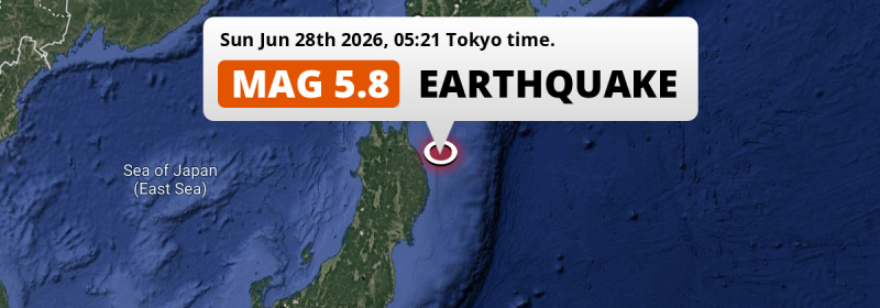
In the early morning of Sunday June 28th, 2026, a significant M5.8 aftershock hit in the North Pacific Ocean 83 kilometer from Hachinohe, Japan. Roughly 3.9 million people may have felt this earthquake.
Felt the earthquake? Share this article: 


Earthquake Summary
This earthquake hit under water in the North Pacific Ocean, 61 kilometers (38 mi) off the coast of Japan, 83 kilometer east of Hachinohe in Aomori. The center of this earthquake had a quite shallow depth of 34 km. Shallow earthquakes usually have a larger impact than earthquakes deep in the earth.
| Date and Time: | Jun 28, 2026 05:21 (Tokyo Time) - Jun 27, 2026 20:21 Universal Time. |
|---|---|
| Location: | 83 km east of Hachinohe, Aomori, Japan. Coordinates 40°15'13"N 142°25'33"E. |
| Map: | 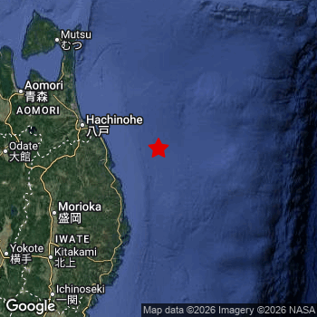 Map of area around epicenter. Click to open in Google Maps. |
| Magnitude: | MAG 5.8 Detected by 30 stations. Maximum Error Range ±0.057 . |
| Depth: | 34 km (21 mi) A quite shallow depth. |
| Max. Intensity: | V
Moderate On the Modified Mercalli Scale. |
| Tsunami Risk: | Low tsunami risk Earthquakes under MAG-6.5 do not usually cause tsunami's. Always stay cautious - More info here. |
Minimal impact predicted
Based on scientific estimates by the US Geographic Survey (USGS), the risk of high fatalities for this earthquake is classified at level GREEN (low). They expect an 90% likelyhood of between 0 and 1 fatalities.
The USGS classifies the economic impact of this earthquake at level GREEN (low). They expect an 90% likelyhood of between 0 and 1 million US Dollars in economic damage and impact.
Roughly 3.9 million people exposed to shaking
An estimated 3.9 million have been exposed to shaking (An MMI or Modified Mercalli Intensity level II or higher) as a result of this earthquake according scientific estimates published by the USGS.
An estimated 167,500 people were exposed to level V. At this level, moderate shaking and very light damage can be expected. The majority of people (roughly 2 million) live in an area exposed to level IV, where light shaking and likely no damage is expected. All exposure to shaking was within the borders of Japan .
| People | MMI Level | Shaking | Damage |
|---|---|---|---|
| 0 | I |
Not noticable | None |
| 140 | II |
Very weak | None |
| 1,728,000 | III |
Weak | Probably none |
| 2,002,000 | IV |
Light | Likely none |
| 167,500 | V |
Moderate | Very light |
| 0 | VI |
Strong | Light |
| 0 | VII |
Very Strong | Moderate |
| 0 | VIII |
Severe | Moderate to heavy |
| 0 | IX |
Violent | Heavy |
| 0 | X |
Extreme | Very heavy |
Nearby towns and cities
This earthquake may have been felt in Japan . Miyako in Iwate, Japan is the nearest significant place from the epicenter. The earthquake occurred 79 kilometer (49 mi) north-east of Miyako. The intensity of shaking and damage in Miyako is estimated to be around level IV on the Modified Mercalli Intensity scale (light shaking, likely no damage).
Multiple major population centers exist within 300km of the earthquake that struck today. Sapporo is located 325 km to the north (intensity unknown, possibly low). Sendai is located 259 km to the southwest (intensity unknown, possibly low). Hachinohe is located 83 km to the west and experienced an intensity of V (moderate shaking, very light damage).
A complete list of nearby places is included below. Estimated intensity data (MMI) sourced from a shake-map published by the US Geographic Survey is shown where available (cities without data probably experienced little impact).
Overview of nearby places
| Distance | Place | Intensity (MMI) |
|---|---|---|
| 79 km (49 mi) SW from epicenter |
Miyako Iwate, Japan. |
IV
Light |
| 83 km (52 mi) W from epicenter |
Hachinohe Aomori, Japan. |
V
Moderate |
| 96 km (60 mi) SW from epicenter |
Yamada Iwate, Japan. |
IV
Light |
| 100 km (62 mi) NW from epicenter |
Misawa Aomori, Japan. |
V
Moderate |
| 119 km (74 mi) SW from epicenter |
Kamaishi Iwate, Japan. |
III
Weak |
| 125 km (78 mi) SW from epicenter |
Morioka Iwate, Japan. |
IV
Light |
| 129 km (80 mi) SW from epicenter |
Tōno Iwate, Japan. |
IV
Light |
| 138 km (86 mi) SW from epicenter |
Shizukuishi Iwate, Japan. |
IV
Light |
| 139 km (86 mi) W from epicenter |
Hanawa Akita, Japan. |
IV
Light |
| 145 km (90 mi) SW from epicenter |
Ōfunato Iwate, Japan. |
IV
Light |
| 148 km (92 mi) SW from epicenter |
Hanamaki Iwate, Japan. |
IV
Light |
| 154 km (96 mi) NW from epicenter |
Mutsu Aomori, Japan. |
IV
Light |
| 155 km (96 mi) SW from epicenter |
Kitakami Iwate, Japan. |
IV
Light |
| 156 km (97 mi) NW from epicenter |
Aomori Aomori, Japan. |
IV
Light |
| 159 km (99 mi) W from epicenter |
Ōdate Akita, Japan. |
IV
Light |
| 162 km (101 mi) SW from epicenter |
Kanegasaki Iwate, Japan. |
IV
Light |
| 162 km (101 mi) W from epicenter |
Kuroishi Aomori, Japan. |
IV
Light |
| 163 km (101 mi) W from epicenter |
Namioka Aomori, Japan. |
IV
Light |
| 167 km (104 mi) SW from epicenter |
Mizusawa Iwate, Japan. |
IV
Light |
| 170 km (106 mi) W from epicenter |
Hirosaki Aomori, Japan. |
III
Weak |
| 175 km (109 mi) W from epicenter |
Takanosu Akita, Japan. |
III
Weak |
| 179 km (111 mi) W from epicenter |
Goshogawara Aomori, Japan. |
IV
Light |
| 184 km (114 mi) W from epicenter |
Shimokizukuri Aomori, Japan. |
IV
Light |
| 185 km (115 mi) SW from epicenter |
Ichinoseki Iwate, Japan. |
III
Weak |
| 188 km (117 mi) SW from epicenter |
Ōmagari Akita, Japan. |
IV
Light |
| 191 km (119 mi) SW from epicenter |
Yokote Akita, Japan. |
III
Weak |
| 204 km (127 mi) SW from epicenter |
Yuzawa Akita, Japan. |
III
Weak |
| 204 km (127 mi) W from epicenter |
Noshiro Akita, Japan. |
|
| 206 km (128 mi) W from epicenter |
Akita Akita, Japan. |
|
| 221 km (137 mi) NW from epicenter |
Hakodate Hokkaido, Japan. |
III
Weak |
| 226 km (140 mi) SW from epicenter |
Ishinomaki Miyagi, Japan. |
|
| 226 km (140 mi) SW from epicenter |
Furukawa Miyagi, Japan. |
IV
Light |
| 229 km (142 mi) NW from epicenter |
Kamiiso Hokkaido, Japan. |
III
Weak |
| 246 km (153 mi) SW from epicenter |
Shiogama Miyagi, Japan. |
|
| 246 km (153 mi) SW from epicenter |
Tomiya Miyagi, Japan. |
|
| 259 km (161 mi) NW from epicenter |
Muroran Hokkaido, Japan. |
|
| 259 km (161 mi) SW from epicenter |
Sendai Miyagi, Japan. |
|
| 266 km (165 mi) SW from epicenter |
Sakata Yamagata, Japan. |
|
| 274 km (170 mi) N from epicenter |
Tomakomai Hokkaido, Japan. |
|
| 276 km (171 mi) SW from epicenter |
Tendō Yamagata, Japan. |
|
| 281 km (175 mi) SW from epicenter |
Tsuruoka Yamagata, Japan. |
|
| 286 km (178 mi) SW from epicenter |
Yamagata Yamagata, Japan. |
|
| 292 km (181 mi) N from epicenter |
Chitose Hokkaido, Japan. |
|
| 303 km (188 mi) N from epicenter |
Obihiro Hokkaido, Japan. |
|
| 325 km (202 mi) N from epicenter |
Sapporo Hokkaido, Japan. |
|
| 326 km (203 mi) SW from epicenter |
Fukushima Fukushima, Japan. |
|
| 343 km (213 mi) NE from epicenter |
Kushiro Hokkaido, Japan. |
|
| 363 km (226 mi) SW from epicenter |
Kōriyama Fukushima, Japan. |
|
| 381 km (237 mi) S from epicenter |
Iwaki Fukushima, Japan. |
|
| 391 km (243 mi) N from epicenter |
Asahikawa Hokkaido, Japan. |
|
| 395 km (245 mi) SW from epicenter |
Niigata Niigata, Japan. |
Earthquake Intensity Map
The graph below overlays a map of the region around the epicenter with earthquake intensity data provided by the US Geographic Survey. The highest intensity level detected for this earthquake is V.

Shaking reported by 11 people
People that feel an earthquake may report their experience to the US Geographic Survey. Currently, 11 people have reported shaking in 7 places, all within Japan.We keep updating this article as more ground reports become available. You may report that you felt this earthquake here.
Places with most reports:
- Sendai, Miyagi, Japan: 3 people.
- Hachinohe, Aomori, Japan: 2 people.
- Misawa, Aomori, Japan: 2 people.
- Morioka, Iwate, Japan: 1 person.
- Obihiro, Hokkaido, Japan: 1 person.
- Hamamatsu, Shizuoka, Japan: 1 person.
- Tanashi, Tokio, Japan: 1 person.
This is likely an aftershock
This earthquake was an aftershock. A larger mag. 6.9 earthquake struck 22 km (14 mi) west in advance of this 5.8 earthquake around 3 days earlier.
Overview of foreshocks and aftershocks
| Classification | Magnitude | When | Where |
|---|---|---|---|
| Main Shock | M 6.9 |
Jun 25, 2026 07:30 (Tokyo Time) | - |
| Aftershock | M 3.6 |
36 mins later Jun 25, 2026 08:06 (Tokyo Time) | 13 km (8 mi) SE from Main Shock. |
| Aftershock | M 3.3 |
42 mins later Jun 25, 2026 08:12 (Tokyo Time) | 6 km (4 mi) NE from Main Shock. |
| Aftershock | M 3.1 |
52 mins later Jun 25, 2026 08:22 (Tokyo Time) | 6 km (4 mi) NE from Main Shock. |
| Aftershock | M 3.9 |
2 hrs later Jun 25, 2026 09:08 (Tokyo Time) | 13 km (8 mi) SE from Main Shock. |
| Aftershock | M 4.3 |
2 hrs later Jun 25, 2026 09:33 (Tokyo Time) | 22 km (13 mi) NE from Main Shock. |
| Aftershock | M 4.1 |
3 hrs later Jun 25, 2026 10:11 (Tokyo Time) | 10 km (6 mi) N from Main Shock. |
| Aftershock | M 3.6 |
3 hrs later Jun 25, 2026 10:48 (Tokyo Time) | 13 km (8 mi) SE from Main Shock. |
| Aftershock | M 3.2 |
12 hrs later Jun 25, 2026 19:21 (Tokyo Time) | 62 km (38 mi) S from Main Shock. |
| Aftershock | M 4.8 |
13 hrs later Jun 25, 2026 20:58 (Tokyo Time) | 28 km (17 mi) NW from Main Shock. |
| Aftershock | M 4.7 |
18 hrs later Jun 26, 2026 01:11 (Tokyo Time) | 31 km (19 mi) NW from Main Shock. |
| Aftershock | M 4.1 |
19 hrs later Jun 26, 2026 02:48 (Tokyo Time) | 73 km (46 mi) N from Main Shock. |
| Aftershock | M 3.7 |
22 hrs later Jun 26, 2026 05:02 (Tokyo Time) | 13 km (8 mi) NE from Main Shock. |
| Aftershock | M 4.4 |
1 day later Jun 26, 2026 16:22 (Tokyo Time) | 84 km (52 mi) E from Main Shock. |
| Aftershock | M 4.2 |
2 days later Jun 27, 2026 09:50 (Tokyo Time) | 12 km (7 mi) E from Main Shock. |
| Aftershock This Earthquake |
M 5.8 |
3 days later Jun 28, 2026 05:21 (Tokyo Time) | 22 km (14 mi) E from Main Shock. |
| Aftershock | M 3.5 |
3 days later Jun 28, 2026 09:12 (Tokyo Time) | 17 km (10 mi) N from Main Shock. |
| Aftershock | M 4.5 |
3 days later Jun 28, 2026 14:39 (Tokyo Time) | 17 km (11 mi) E from Main Shock. |
| Aftershock | M 4.2 |
4 days later Jun 28, 2026 23:49 (Tokyo Time) | 2.2 km (1.4 mi) NE from Main Shock. |
| Aftershock | M 4.4 |
4 days later Jun 29, 2026 08:11 (Tokyo Time) | 52 km (32 mi) NW from Main Shock. |
| Aftershock | M 3.4 |
5 days later Jun 30, 2026 09:38 (Tokyo Time) | 44 km (27 mi) SE from Main Shock. |
| Aftershock | M 3.6 |
5 days later Jun 30, 2026 12:24 (Tokyo Time) | 17 km (10 mi) N from Main Shock. |
| Aftershock | M 4.8 |
6 days later Jun 30, 2026 23:02 (Tokyo Time) | 20 km (12 mi) SE from Main Shock. |
More earthquakes coming?
The risk of aftershocks decreases rapidly over time. Usually, aftershocks are at least one order of magnitude lower than a main shock.
The chance that a significant earthquake like this one is followed by an even larger earthquake is not so large. On average, scientists estimate a 94% chance that a major earthquake will not be followed by an even larger one. It is still adviced to be aware of this risk
Read: How to Stay Safe during an Earthquake (cdc.gov).Earthquakes like this happen often in the region
Earthquakes of this strength are very common in the region. In total, 45 earthquakes with a magnitude of 5.8 or higher have been registered within 300km (186 mi) of this epicenter in the past 10 years. This comes down to an average of once every 3 months.
Low tsunami risk
Based on early data it appears this earthquake was not strong enough (lower than MAG-6.5) to be likely to cause destructive tsunami's. However this earthquake appeared to have hit at a shallow depth under sea, so stay cautious and monitor advice from local authorities.
Tsunami Risk Factors
| Factor | Under Sea? | MAG-6.5 or stronger? | Shallow depth? |
|---|---|---|---|
| Explanation | Almost all tsunami's are caused by earthquakes with their epicenter under sea or very near the sea. However stay cautious in coastal areas as earthquakes on land may cause landslides into sea, potentially still causing a local tsunami. | Under MAG 6.5: Very unlikely to cause a tsunami. MAG 6.5 to 7.5: Destructive tsunami's do occur, but are uncommon. Likely to observe small sea level changes. MAG 7.6+: Earthquakes with these magnitudes might produce destructive tsunami's. |
Most destructive tsunami's are caused by shallow earthquakes with a depth between 0 and 100km under the surface of the earth. Deeper tsunami's are unlikely to displace to ocean floor. |
| This Earthquake | This earthquake appears to have struck under the sea. | Not this earthquake. This earthquake had a magnitude of 5.8. Earthquakes of this strength are unlikely to trigger a tsunami. |
This earthquake occurred at a depth of of 34 km (21 mi). Earthquakes this shallow could trigger a tsunami. |
Sources
Last updated 19/07/26 22:18 (). As more information on this earthquake becomes available this article will be updated. This article is automatically composed based on data originating from multiple sources.
- US Geographic Society (USGS): Earthquake us6000t8qd
- European-Mediterranean Seismological Centre (EMSC): Earthquake 20260627_0000292
- Geonames.org: World Cities Database
- Google Maps: Static API
- Earthquakelist.org: Historic Earthquakes Database
Share this article:
