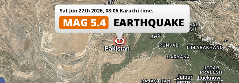
In the morning of Saturday June 27th, 2026, a shallow and significant Magnitude 5.3 earthquake hit under land 96 kilometer from Dera Ghazi Khan in Pakistan. Around 38 million people have been exposed to shaking.
Felt the earthquake? Share this article: 


Earthquake Summary
The earthquake struck on land in Pakistan, 96 kilometer (60 mi) northwest of Dera Ghazi Khan in Punjab. The center of this earthquake had a very shallow depth of 10 km. Shallow earthquakes usually have a larger impact than earthquakes deep in the earth.
| Date and Time: | Jun 27, 2026 08:06 (Karachi Time) - Jun 27, 2026 03:06 Universal Time. |
|---|---|
| Location: | 96 km NW of Dera Ghazi Khan, Punjab, Pakistan. Coordinates 30°28'58"N 69°46'27"E. |
| Map: | 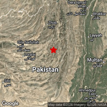 Map of area around epicenter. Click to open in Google Maps. |
| Magnitude: | MAG 5.3 Detected by 68 stations. Maximum Error Range ±0.07 . |
| Depth: | 10 km (6 mi) A very shallow depth. |
| Max. Intensity: | VII
Very Strong On the Modified Mercalli Scale. |
| Tsunami Risk: | Tsunami very unlikely While this was a shallow earthquake, it appears to have occurred under land with a magnitude not strong enough to cause tsunami's. Always stay cautious - More info here. |
Minimal impact predicted
Based on scientific estimates by the US Geographic Survey (USGS), the risk of high fatalities for this earthquake is classified at level GREEN (low). They expect an 90% likelyhood of between 0 and 1 fatalities.
The USGS classifies the economic impact of this earthquake at level GREEN (low). They expect an 90% likelyhood of between 0 and 1 million US Dollars in economic damage and impact.
Roughly 38 million people exposed to shaking
This earthquake may have been felt by around 38 million people. That is the expected population size of the area exposed to a level of shaking of II or higher on the Modified Mercalli scale according to the USGS.
An estimated 300 people were exposed to level VII. At this level, very strong shaking and likely moderate damage can be expected. The majority of people (roughly 32 million) live in an area exposed to level III, where weak shaking and probably no damage is expected.
People in 2 countries have been exposed to shaking. In Pakistan , around 38 million people, with impact levels up to VII (very strong shaking, likely moderate damage). Shaking was experienced by inhabitants of Afghanistan too.
| People | MMI Level | Shaking | Damage |
|---|---|---|---|
| 0 | I |
Not noticable | None |
| 57,740 | II |
Very weak | None |
| 32,350,000 | III |
Weak | Probably none |
| 5,714,000 | IV |
Light | Likely none |
| 28,950 | V |
Moderate | Very light |
| 6,630 | VI |
Strong | Light |
| 300 | VII |
Very Strong | Moderate |
| 0 | VIII |
Severe | Moderate to heavy |
| 0 | IX |
Violent | Heavy |
| 0 | X |
Extreme | Very heavy |
Nearby towns and cities
This earthquake may have been felt in Pakistan . Taunsa in Punjab, Pakistan is the nearest significant place from the epicenter. The earthquake occurred 87 kilometer (54 mi) west of Taunsa. Taunsa experienced an earthquake intensity (MMI Scale) of roughly IV. That level implies light shaking and likely no damage.
Multiple large cities are in proximity of today's earthquake. Multan is located 167 km to the east and experienced an intensity of III (weak shaking, probably no damage). Rahim Yar Khan is located 235 km to the south (intensity unknown, possibly low). Quetta is located 268 km to the west (intensity unknown, possibly low).
An overview of nearby towns and cities is available in the overview below. If places don't have intensity data available, it likely means the experienced impact in those places was fairly small.
Overview of nearby places
| Distance | Place | Intensity (MMI) |
|---|---|---|
| 87 km (54 mi) E from epicenter |
Taunsa Punjab, Pakistan. |
IV
Light |
| 96 km (60 mi) SE from epicenter |
Dera Ghazi Khan Punjab, Pakistan. |
IV
Light |
| 100 km (62 mi) N from epicenter |
Zhob Balochistan, Pakistan. |
III
Weak |
| 113 km (70 mi) W from epicenter |
Loralai Balochistan, Pakistan. |
IV
Light |
| 114 km (71 mi) E from epicenter |
Kot Addu Punjab, Pakistan. |
IV
Light |
| 118 km (73 mi) SE from epicenter |
Dajal Punjab, Pakistan. |
IV
Light |
| 122 km (76 mi) SE from epicenter |
Jampur Punjab, Pakistan. |
IV
Light |
| 123 km (76 mi) NE from epicenter |
Layyah Punjab, Pakistan. |
III
Weak |
| 139 km (86 mi) NE from epicenter |
Karor Punjab, Pakistan. |
III
Weak |
| 144 km (89 mi) E from epicenter |
Muzaffargarh Punjab, Pakistan. |
III
Weak |
| 147 km (91 mi) SE from epicenter |
Khangarh Punjab, Pakistan. |
III
Weak |
| 149 km (93 mi) SE from epicenter |
Jatoi Shimali Punjab, Pakistan. |
III
Weak |
| 157 km (98 mi) SE from epicenter |
Shahr Sultan Punjab, Pakistan. |
III
Weak |
| 157 km (98 mi) NE from epicenter |
Chak Two Hundred Forty-nine Thal Development Authority Punjab, Pakistan. |
III
Weak |
| 161 km (100 mi) SE from epicenter |
Shujaabad Punjab, Pakistan. |
III
Weak |
| 162 km (101 mi) S from epicenter |
Rajanpur Punjab, Pakistan. |
III
Weak |
| 164 km (102 mi) SE from epicenter |
Alipur Punjab, Pakistan. |
III
Weak |
| 167 km (104 mi) E from epicenter |
Multan Punjab, Pakistan. |
III
Weak |
| 171 km (106 mi) S from epicenter |
Dera Bugti Balochistan, Pakistan. |
III
Weak |
| 174 km (108 mi) N from epicenter |
Kulachi Khyber Pakhtunkhwa, Pakistan. |
III
Weak |
| 177 km (110 mi) NE from epicenter |
Bhakkar Punjab, Pakistan. |
III
Weak |
| 177 km (110 mi) SE from epicenter |
Jalalpur Pirwala Punjab, Pakistan. |
III
Weak |
| 183 km (114 mi) E from epicenter |
Qadirpur Ran Punjab, Pakistan. |
III
Weak |
| 184 km (114 mi) NE from epicenter |
Dera Ismail Khan Khyber Pakhtunkhwa, Pakistan. |
III
Weak |
| 190 km (118 mi) E from epicenter |
Ahmadpur Sial Punjab, Pakistan. |
III
Weak |
| 190 km (118 mi) NE from epicenter |
Shorkot Khyber Pakhtunkhwa, Pakistan. |
III
Weak |
| 199 km (124 mi) S from epicenter |
Zahir Pir Punjab, Pakistan. |
III
Weak |
| 200 km (124 mi) E from epicenter |
Kabirwala Punjab, Pakistan. |
|
| 207 km (129 mi) SE from epicenter |
Ahmadpur East Punjab, Pakistan. |
III
Weak |
| 208 km (129 mi) SE from epicenter |
Lodhran Punjab, Pakistan. |
III
Weak |
| 210 km (130 mi) SW from epicenter |
Sibi Balochistan, Pakistan. |
III
Weak |
| 218 km (135 mi) NE from epicenter |
Dullewala Punjab, Pakistan. |
III
Weak |
| 219 km (136 mi) SE from epicenter |
Bahawalpur Punjab, Pakistan. |
III
Weak |
| 221 km (137 mi) SE from epicenter |
Khanpur Punjab, Pakistan. |
III
Weak |
| 227 km (141 mi) SE from epicenter |
Kahror Pakka Punjab, Pakistan. |
|
| 235 km (146 mi) S from epicenter |
Rahim Yar Khan Punjab, Pakistan. |
|
| 243 km (151 mi) E from epicenter |
Mailsi Punjab, Pakistan. |
|
| 244 km (152 mi) S from epicenter |
Saddiqabad Punjab, Pakistan. |
|
| 248 km (154 mi) E from epicenter |
Mian Channun Punjab, Pakistan. |
|
| 253 km (157 mi) E from epicenter |
Vihari Punjab, Pakistan. |
|
| 255 km (158 mi) S from epicenter |
Kandhkot Sindh, Pakistan. |
|
| 258 km (160 mi) E from epicenter |
Jhang Sadr Punjab, Pakistan. |
|
| 265 km (165 mi) E from epicenter |
Toba Tek Singh Punjab, Pakistan. |
|
| 268 km (167 mi) W from epicenter |
Quetta Balochistan, Pakistan. |
|
| 276 km (171 mi) E from epicenter |
Kamalia Punjab, Pakistan. |
|
| 277 km (172 mi) SW from epicenter |
Jacobabad Sindh, Pakistan. |
|
| 278 km (173 mi) E from epicenter |
Burewala Punjab, Pakistan. |
|
| 280 km (174 mi) E from epicenter |
Chichawatni Punjab, Pakistan. |
|
| 281 km (175 mi) E from epicenter |
Hasilpur Punjab, Pakistan. |
|
| 286 km (178 mi) NE from epicenter |
Mianwali Punjab, Pakistan. |
|
| 288 km (179 mi) E from epicenter |
Gojra Punjab, Pakistan. |
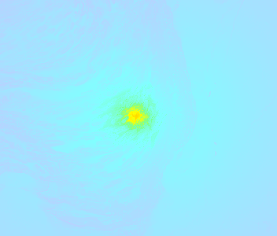
Earthquake Intensity Map
The graph below overlays a map of the region around the epicenter with earthquake intensity data provided by the US Geographic Survey. The highest intensity level detected for this earthquake is VII.
Aftershocks detected
In the days before this main shock, 3 smaller foreshocks were detected. A 5.2 magnitude earthquake hit 15 hrs earlier nearby.
Overview of foreshocks and aftershocks
| Classification | Magnitude | When | Where |
|---|---|---|---|
| Foreshock | M 4.7 |
21 hrs earlier Jun 26, 2026 10:57 (Karachi Time) | 26 km (16 mi) S from Main Shock. |
| Foreshock | M 5.2 |
15 hrs earlier Jun 26, 2026 16:48 (Karachi Time) | 19 km (12 mi) SW from Main Shock. |
| Foreshock | M 4.4 |
2 hrs earlier Jun 27, 2026 05:44 (Karachi Time) | 61 km (38 mi) W from Main Shock. |
| Main Shock This Earthquake |
M 5.3 |
Jun 27, 2026 08:06 (Karachi Time) | - |
More earthquakes coming?
The risk of aftershocks decreases rapidly over time. Usually, aftershocks are at least one order of magnitude lower than a main shock.
The chance that a significant earthquake like this one is followed by an even larger earthquake is not so large. On average, scientists estimate a 94% chance that a major earthquake will not be followed by an even larger one. It is still adviced to be aware of this risk
Read: How to Stay Safe during an Earthquake (cdc.gov).This is the strongest earthquake in 4 years
Earthquakes of this strength occur quite regularly in the region. This is the strongest earthquake to hit since June 21st, 2022, when a 6 magnitude earthquake hit 284 km (176 mi) further north. That was also the heaviest earthquake to hit the region in the past 10 years.
In total, 3 earthquakes with a magnitude of 5.3 or higher have been registered within 300km (186 mi) of this epicenter in the past 10 years. This comes down to an average of once every 3 years.
Tsunami very unlikely
While MAG-6.5+ earthquakes may cause tsunami's, it appears that the epicenter of this earthquake hit under land. In addition, the reported depth is deeper than 100km, making the risk of a tsunami even less likely. However always stay cautious and monitor advice from local authorities.
Tsunami Risk Factors
| Factor | Under Sea? | MAG-6.5 or stronger? | Shallow depth? |
|---|---|---|---|
| Explanation | Almost all tsunami's are caused by earthquakes with their epicenter under sea or very near the sea. However stay cautious in coastal areas as earthquakes on land may cause landslides into sea, potentially still causing a local tsunami. | Under MAG 6.5: Very unlikely to cause a tsunami. MAG 6.5 to 7.5: Destructive tsunami's do occur, but are uncommon. Likely to observe small sea level changes. MAG 7.6+: Earthquakes with these magnitudes might produce destructive tsunami's. |
Most destructive tsunami's are caused by shallow earthquakes with a depth between 0 and 100km under the surface of the earth. Deeper tsunami's are unlikely to displace to ocean floor. |
| This Earthquake | Not this earthquake. This earthquake appears to have struck on land far from any coast. |
Not this earthquake. This earthquake had a magnitude of 5.3. Earthquakes of this strength are unlikely to trigger a tsunami. |
This earthquake occurred at a depth of of 10 km (6 mi). Earthquakes this shallow could trigger a tsunami. |
Sources
Last updated 21/07/26 01:38 (). As more information on this earthquake becomes available this article will be updated. This article is automatically composed based on data originating from multiple sources.
- US Geographic Society (USGS): Earthquake us6000t8le
- European-Mediterranean Seismological Centre (EMSC): Earthquake 20260627_0000043
- Geonames.org: World Cities Database
- Google Maps: Static API
- Earthquakelist.org: Historic Earthquakes Database
Share this article:
