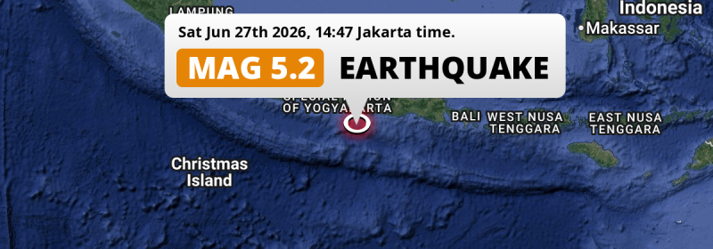
In the Indian Ocean 155 kilometer from Yogyakarta, Indonesia, a significant M5.2 earthquake occurred in the afternoon of Saturday June 27th, 2026.
Felt the earthquake? Share this article: 


Earthquake Summary
This earthquake hit under water in the Indian Ocean, 78 kilometers (49 mi) off the coast of Indonesia, 155 kilometer south-east of Yogyakarta. The center of this earthquake had a quite shallow depth of 66 km. Shallow earthquakes usually have a larger impact than earthquakes deep in the earth.
| Date and Time: | Jun 27, 2026 14:47 (Jakarta Time) - Jun 27, 2026 07:47 Universal Time. |
|---|---|
| Location: | 155 km SE of Yogyakarta, Indonesia. Coordinates 8°57'23"S 111°8'60"E. |
| Map: | 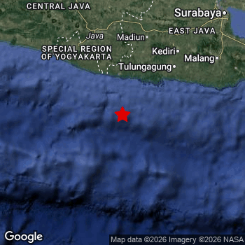 Map of area around epicenter. Click to open in Google Maps. |
| Magnitude: | MAG 5.2 Detected by 13 stations. Maximum Error Range ±0.086 . |
| Depth: | 66 km (41 mi) A quite shallow depth. |
| Tsunami Risk: | Low tsunami risk Earthquakes under MAG-6.5 do not usually cause tsunami's. Always stay cautious - More info here. |
Nearby towns and cities
This earthquake may have been felt in Indonesia . The closest significant population center near the earthquake is Trenggalek in East Java, Indonesia. Trenggalek is located 115 kilometer (71 mi) southwest of the epicenter.
Multiple major population centers exist within 300km of the earthquake that struck today. Surabaya is located 259 km to the north-east. Semarang is located 233 km to the north. Yogyakarta is located 155 km to the northwest.
An overview of nearby towns and cities is available in the overview below.
Overview of nearby places
| Distance | Place |
|---|---|
| 115 km (71 mi) NE from epicenter |
Trenggalek East Java, Indonesia. |
| 119 km (74 mi) N from epicenter |
Jatiroto Central Java, Indonesia. |
| 124 km (77 mi) NE from epicenter |
Boyolangu East Java, Indonesia. |
| 126 km (78 mi) N from epicenter |
Ponorogo East Java, Indonesia. |
| 129 km (80 mi) NE from epicenter |
Tulungagung East Java, Indonesia. |
| 130 km (81 mi) NE from epicenter |
Kedungwaru East Java, Indonesia. |
| 134 km (83 mi) NE from epicenter |
Ngunut East Java, Indonesia. |
| 134 km (83 mi) N from epicenter |
Selogiri Central Java, Indonesia. |
| 147 km (91 mi) NW from epicenter |
Bambanglipuro Yogyakarta, Indonesia. |
| 147 km (91 mi) NE from epicenter |
Blitar East Java, Indonesia. |
| 148 km (92 mi) NW from epicenter |
Sewon Yogyakarta, Indonesia. |
| 149 km (93 mi) NW from epicenter |
Pandak Yogyakarta, Indonesia. |
| 149 km (93 mi) NW from epicenter |
Bantul Yogyakarta, Indonesia. |
| 149 km (93 mi) NW from epicenter |
Wedi Central Java, Indonesia. |
| 151 km (94 mi) NW from epicenter |
Klaten Central Java, Indonesia. |
| 152 km (94 mi) NW from epicenter |
Candi Prambanan Central Java, Indonesia. |
| 153 km (95 mi) N from epicenter |
Madiun East Java, Indonesia. |
| 154 km (96 mi) NW from epicenter |
Depok Yogyakarta, Indonesia. |
| 155 km (96 mi) N from epicenter |
Baki Central Java, Indonesia. |
| 155 km (96 mi) NW from epicenter |
Yogyakarta Yogyakarta, Indonesia. |
| 155 km (96 mi) N from epicenter |
Grogol Central Java, Indonesia. |
| 155 km (96 mi) NW from epicenter |
Kasihan Yogyakarta, Indonesia. |
| 156 km (97 mi) N from epicenter |
Karanganom Central Java, Indonesia. |
| 158 km (98 mi) NW from epicenter |
Gamping Lor Yogyakarta, Indonesia. |
| 159 km (99 mi) NE from epicenter |
Kediri East Java, Indonesia. |
| 160 km (99 mi) N from epicenter |
Gatak Central Java, Indonesia. |
| 160 km (99 mi) N from epicenter |
Surakarta Central Java, Indonesia. |
| 161 km (100 mi) NW from epicenter |
Melati Yogyakarta, Indonesia. |
| 162 km (101 mi) NW from epicenter |
Godean Yogyakarta, Indonesia. |
| 163 km (101 mi) NE from epicenter |
Gampengrejo East Java, Indonesia. |
| 163 km (101 mi) NW from epicenter |
Sleman Yogyakarta, Indonesia. |
| 163 km (101 mi) N from epicenter |
Kartasura Central Java, Indonesia. |
| 170 km (106 mi) N from epicenter |
Boyolali Central Java, Indonesia. |
| 171 km (106 mi) N from epicenter |
Sragen Central Java, Indonesia. |
| 172 km (107 mi) NE from epicenter |
Nganjuk East Java, Indonesia. |
| 175 km (109 mi) NE from epicenter |
Pare East Java, Indonesia. |
| 180 km (112 mi) NW from epicenter |
Muntilan Central Java, Indonesia. |
| 181 km (112 mi) NE from epicenter |
Kepanjen East Java, Indonesia. |
| 185 km (115 mi) NE from epicenter |
Kertosono East Java, Indonesia. |
| 189 km (117 mi) NW from epicenter |
Mertoyudan Central Java, Indonesia. |
| 194 km (121 mi) NW from epicenter |
Magelang Central Java, Indonesia. |
| 194 km (121 mi) NE from epicenter |
Batu East Java, Indonesia. |
| 195 km (121 mi) N from epicenter |
Salatiga Central Java, Indonesia. |
| 196 km (122 mi) NE from epicenter |
Malang East Java, Indonesia. |
| 197 km (122 mi) NE from epicenter |
Jombang East Java, Indonesia. |
| 209 km (130 mi) N from epicenter |
Purwodadi Central Java, Indonesia. |
| 211 km (131 mi) NE from epicenter |
Lawang East Java, Indonesia. |
| 233 km (145 mi) N from epicenter |
Semarang Central Java, Indonesia. |
| 259 km (161 mi) NE from epicenter |
Surabaya East Java, Indonesia. |
| 281 km (175 mi) NW from epicenter |
Pekalongan Central Java, Indonesia. |
| 294 km (183 mi) E from epicenter |
Jember East Java, Indonesia. |
Shaking reported by 10 people
People that feel an earthquake may report their experience to the US Geographic Survey. Currently, 10 people have reported shaking in 8 places, all within Indonesia.We keep updating this article as more ground reports become available. You may report that you felt this earthquake here.
Places with most reports:
- Surakarta, Jawa Tengah, Indonesia: 2 people.
- Kasihan, Yogyakarta, Indonesia: 2 people.
- Jetis, Yogyakarta, Indonesia: 1 person.
- Yogyakarta, Yogyakarta, Indonesia: 1 person.
- Prambanan, Jawa Tengah, Indonesia: 1 person.
- Wonosari, Yogyakarta, Indonesia: 1 person.
- Madiun, Jawa Timur, Indonesia: 1 person.
- Depok, Yogyakarta, Indonesia: 1 person.
17 Aftershocks detected
This main shock was followed by 17 smaller aftershocks. At a distance of 96 km (59 mi) east of this earthquake, an aftershock struck 1 day later. It measured a magnitude of 3.5
Before this earthquake struck, 11 smaller foreshocks occurred. Roughly 1 day before this earthquake, a foreshock measuring MAG-2.9 was detected nearby this earthquake.
Overview of foreshocks and aftershocks
| Classification | Magnitude | When | Where |
|---|---|---|---|
| Foreshock | M 2.5 |
2 days earlier Jun 24, 2026 02:24 (Jakarta Time) | 20 km (12 mi) E from Main Shock. |
| Foreshock | M 2.7 |
2 days earlier Jun 24, 2026 03:25 (Jakarta Time) | 53 km (33 mi) SE from Main Shock. |
| Foreshock | M 2.6 |
2 days earlier Jun 24, 2026 08:09 (Jakarta Time) | 83 km (51 mi) NE from Main Shock. |
| Foreshock | M 2.6 |
2 days earlier Jun 24, 2026 10:33 (Jakarta Time) | 18 km (11 mi) SE from Main Shock. |
| Foreshock | M 2.6 |
2 days earlier Jun 24, 2026 18:12 (Jakarta Time) | 40 km (25 mi) E from Main Shock. |
| Foreshock | M 2.6 |
2 days earlier Jun 24, 2026 21:27 (Jakarta Time) | 51 km (32 mi) SE from Main Shock. |
| Foreshock | M 2.9 |
1 day earlier Jun 25, 2026 05:49 (Jakarta Time) | 17 km (11 mi) NW from Main Shock. |
| Foreshock | M 2.7 |
18 hrs earlier Jun 25, 2026 17:36 (Jakarta Time) | 51 km (32 mi) SW from Main Shock. |
| Foreshock | M 2.6 |
10 hrs earlier Jun 26, 2026 00:55 (Jakarta Time) | 34 km (21 mi) SW from Main Shock. |
| Foreshock | M 2.6 |
7 hrs earlier Jun 26, 2026 04:35 (Jakarta Time) | 47 km (29 mi) E from Main Shock. |
| Foreshock | M 2.5 |
5 hrs earlier Jun 26, 2026 06:02 (Jakarta Time) | 78 km (48 mi) E from Main Shock. |
| Main Shock | M 3.8 |
Jun 26, 2026 11:20 (Jakarta Time) | - |
| Aftershock | M 2.5 |
5 hrs later Jun 26, 2026 16:10 (Jakarta Time) | 43 km (27 mi) N from Main Shock. |
| Aftershock | M 2.6 |
5 hrs later Jun 26, 2026 16:39 (Jakarta Time) | 42 km (26 mi) SE from Main Shock. |
| Aftershock | M 2.5 |
7 hrs later Jun 26, 2026 18:48 (Jakarta Time) | 78 km (49 mi) N from Main Shock. |
| Aftershock | M 2.5 |
12 hrs later Jun 26, 2026 22:54 (Jakarta Time) | 27 km (17 mi) NE from Main Shock. |
| Aftershock | M 2.5 |
14 hrs later Jun 27, 2026 01:29 (Jakarta Time) | 44 km (27 mi) NW from Main Shock. |
| Aftershock | M 3.5 |
1 day later Jun 27, 2026 14:51 (Jakarta Time) | 96 km (59 mi) E from Main Shock. |
| Aftershock | M 2.6 |
1 day later Jun 27, 2026 15:02 (Jakarta Time) | 96 km (60 mi) E from Main Shock. |
| Aftershock | M 2.5 |
1 day later Jun 27, 2026 15:05 (Jakarta Time) | 97 km (60 mi) E from Main Shock. |
| Aftershock | M 2.5 |
1 day later Jun 27, 2026 15:53 (Jakarta Time) | 96 km (60 mi) E from Main Shock. |
| Aftershock | M 2.5 |
1 day later Jun 27, 2026 16:33 (Jakarta Time) | 99 km (62 mi) E from Main Shock. |
| Aftershock | M 3.1 |
1 day later Jun 27, 2026 16:53 (Jakarta Time) | 98 km (61 mi) E from Main Shock. |
| Aftershock | M 2.6 |
1 day later Jun 27, 2026 17:03 (Jakarta Time) | 98 km (61 mi) E from Main Shock. |
| Aftershock | M 2.6 |
1 day later Jun 27, 2026 17:35 (Jakarta Time) | 98 km (61 mi) E from Main Shock. |
| Aftershock | M 2.5 |
1 day later Jun 27, 2026 21:16 (Jakarta Time) | 91 km (57 mi) E from Main Shock. |
| Aftershock | M 2.6 |
1 day later Jun 27, 2026 22:01 (Jakarta Time) | 75 km (47 mi) E from Main Shock. |
| Aftershock | M 2.5 |
1 day later Jun 27, 2026 22:30 (Jakarta Time) | 19 km (12 mi) NW from Main Shock. |
| Aftershock | M 2.6 |
2 days later Jun 28, 2026 00:17 (Jakarta Time) | 98 km (61 mi) E from Main Shock. |
More earthquakes coming?
Earthquakes can create aftershocks. These are generally at least 1 magnitude lower than any main shock, and as time passes the chance and strength of aftershocks decreases.
In only six percent of cases, significant earthquakes are followed by a larger main shock, making the current earthquake a foreshock. While the chance of this happening is not so large, it is adviced to maintain cautiousness in the hours and days following a major earthquake.
Read: How to Stay Safe during an Earthquake (cdc.gov).Earthquakes like this happen often in the region
Earthquakes of this strength are very common in the region. This is the strongest earthquake to hit since February 5th, 2026, when a 5.8 magnitude earthquake hit 13 km (8 mi) further north-east. An even stronger magnitude 6 earthquake struck on April 10th, 2021.
In total, 19 earthquakes with a magnitude of 5.2 or higher have been registered within 300km (186 mi) of this epicenter in the past 10 years. This comes down to an average of once every 6 months.
Low tsunami risk
Based on early data it appears this earthquake was not strong enough (lower than MAG-6.5) to be likely to cause destructive tsunami's. However this earthquake appeared to have hit at a shallow depth under sea, so stay cautious and monitor advice from local authorities.
Tsunami Risk Factors
| Factor | Under Sea? | MAG-6.5 or stronger? | Shallow depth? |
|---|---|---|---|
| Explanation | Almost all tsunami's are caused by earthquakes with their epicenter under sea or very near the sea. However stay cautious in coastal areas as earthquakes on land may cause landslides into sea, potentially still causing a local tsunami. | Under MAG 6.5: Very unlikely to cause a tsunami. MAG 6.5 to 7.5: Destructive tsunami's do occur, but are uncommon. Likely to observe small sea level changes. MAG 7.6+: Earthquakes with these magnitudes might produce destructive tsunami's. |
Most destructive tsunami's are caused by shallow earthquakes with a depth between 0 and 100km under the surface of the earth. Deeper tsunami's are unlikely to displace to ocean floor. |
| This Earthquake | This earthquake appears to have struck under the sea. | Not this earthquake. This earthquake had a magnitude of 5.2. Earthquakes of this strength are unlikely to trigger a tsunami. |
This earthquake occurred at a depth of of 66 km (41 mi). Earthquakes this shallow could trigger a tsunami. |
Sources
Last updated 27/06/26 18:58 (). This article is automatically generated based on available data. We keep checking multiple sources for additional information. This article gets updated as new details on this earthquake become available.
- US Geographic Society (USGS): Earthquake us6000t8me
- Geonames.org: World Cities Database
- Google Maps: Static API
- Earthquakelist.org: Historic Earthquakes Database
Share this article:
