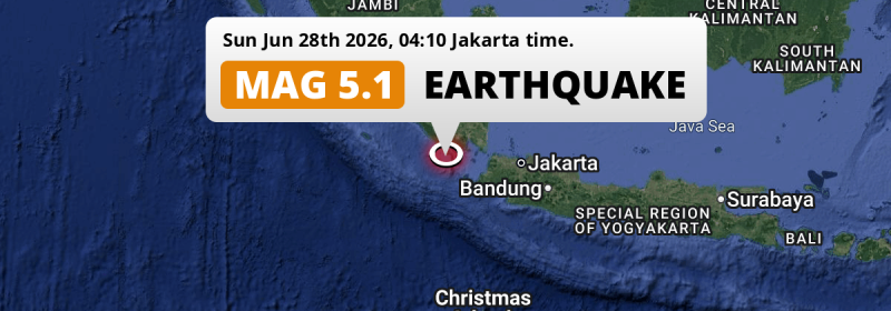
In the night of Sunday June 28th, 2026, a significant M5.0 aftershock hit in the Indian Ocean 87 kilometer from Bandar Lampung, Indonesia.
Felt the earthquake? Share this article: 


Earthquake Summary
This earthquake hit under water in the Indian Ocean, right off the coast of Indonesia (10 mi offshore), 87 kilometer southwest of Bandar Lampung in Lampung. The center of this earthquake had a quite shallow depth of 62 km. Shallow earthquakes usually have a larger impact than earthquakes deep in the earth.
| Date and Time: | Jun 28, 2026 04:10 (Jakarta Time) - Jun 27, 2026 21:10 Universal Time. |
|---|---|
| Location: | 87 km SW of Bandar Lampung, Lampung, Indonesia. Coordinates 6°3'16"S 104°47'28"E. |
| Map: | 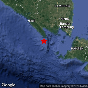 Map of area around epicenter. Click to open in Google Maps. |
| Magnitude: | MAG 5.0 Detected by 67 stations. Maximum Error Range ±0.069 . |
| Depth: | 62 km (38 mi) A quite shallow depth. |
| Tsunami Risk: | Low tsunami risk Earthquakes under MAG-6.5 do not usually cause tsunami's. Always stay cautious - More info here. |
Nearby towns and cities
This earthquake may have been felt in Indonesia . Bandar Lampung in Lampung, Indonesia is the nearest significant place from the epicenter. The earthquake occurred 87 kilometer (54 mi) southwest of Bandar Lampung.
Multiple large cities are in proximity of today's earthquake. Jakarta is located 228 km to the east. Bandar Lampung is located 87 km to the north-east. Tangerang is located 204 km to the east.
A complete list of nearby places is included below.
Overview of nearby places
| Distance | Place |
|---|---|
| 87 km (54 mi) NE from epicenter |
Bandar Lampung Lampung, Indonesia. |
| 119 km (74 mi) NE from epicenter |
Metro Lampung, Indonesia. |
| 120 km (75 mi) E from epicenter |
Labuan Banten, Indonesia. |
| 137 km (85 mi) N from epicenter |
Kotabumi Lampung, Indonesia. |
| 139 km (86 mi) N from epicenter |
Terbanggi Besar Lampung, Indonesia. |
| 148 km (92 mi) E from epicenter |
Pandeglang Banten, Indonesia. |
| 151 km (94 mi) E from epicenter |
Serang Banten, Indonesia. |
| 165 km (103 mi) E from epicenter |
Rangkasbitung Banten, Indonesia. |
| 176 km (109 mi) E from epicenter |
Kresek West Java, Indonesia. |
| 191 km (119 mi) E from epicenter |
Cikupa West Java, Indonesia. |
| 193 km (120 mi) E from epicenter |
Pasarkemis West Java, Indonesia. |
| 197 km (122 mi) E from epicenter |
Curug Banten, Indonesia. |
| 197 km (122 mi) E from epicenter |
Sepatan West Java, Indonesia. |
| 204 km (127 mi) E from epicenter |
Tangerang Banten, Indonesia. |
| 204 km (127 mi) E from epicenter |
Teluknaga West Java, Indonesia. |
| 209 km (130 mi) E from epicenter |
Serpong West Java, Indonesia. |
| 212 km (132 mi) E from epicenter |
Ciputat West Java, Indonesia. |
| 215 km (134 mi) E from epicenter |
South Tangerang Banten, Indonesia. |
| 218 km (135 mi) E from epicenter |
Ciampea West Java, Indonesia. |
| 218 km (135 mi) E from epicenter |
Parung West Java, Indonesia. |
| 218 km (135 mi) E from epicenter |
Pamulang West Java, Indonesia. |
| 220 km (137 mi) SE from epicenter |
Pelabuhanratu West Java, Indonesia. |
| 223 km (139 mi) E from epicenter |
Sawangan West Java, Indonesia. |
| 225 km (140 mi) N from epicenter |
Baturaja South Sumatra, Indonesia. |
| 227 km (141 mi) E from epicenter |
Depok West Java, Indonesia. |
| 228 km (142 mi) E from epicenter |
Jakarta Jakarta, Indonesia. |
| 229 km (142 mi) E from epicenter |
Bogor West Java, Indonesia. |
| 233 km (145 mi) E from epicenter |
Cibinong West Java, Indonesia. |
| 234 km (145 mi) E from epicenter |
Cicurug West Java, Indonesia. |
| 236 km (147 mi) E from epicenter |
Caringin West Java, Indonesia. |
| 236 km (147 mi) E from epicenter |
Citeureup West Java, Indonesia. |
| 243 km (151 mi) E from epicenter |
Cileungsir West Java, Indonesia. |
| 244 km (152 mi) E from epicenter |
Bekasi West Java, Indonesia. |
| 255 km (158 mi) E from epicenter |
Sukabumi West Java, Indonesia. |
| 260 km (162 mi) NW from epicenter |
Tanjungagung South Sumatra, Indonesia. |
| 262 km (163 mi) E from epicenter |
Cikarang West Java, Indonesia. |
| 277 km (172 mi) E from epicenter |
Rengasdengklok West Java, Indonesia. |
| 283 km (176 mi) NW from epicenter |
Pagar Alam South Sumatra, Indonesia. |
| 285 km (177 mi) E from epicenter |
Ciranjang-hilir West Java, Indonesia. |
| 288 km (179 mi) NW from epicenter |
Lahat South Sumatra, Indonesia. |
| 297 km (185 mi) E from epicenter |
Cikampek West Java, Indonesia. |
| 298 km (185 mi) E from epicenter |
Purwakarta West Java, Indonesia. |
| 298 km (185 mi) N from epicenter |
Prabumulih South Sumatra, Indonesia. |
Shaking reported by 1 person
People that feel an earthquake may report their experience to the US Geographic Survey. Currently, 1 person has reported shaking in one place in Indonesia.We keep updating this article as more ground reports become available. You may report that you felt this earthquake here.
Places with most reports:
- Karawang, Jawa Barat, Indonesia: 1 person.
This is likely an aftershock
This earthquake is likely an aftershock of the MAG-5.1 earthquake that struck 8 sec earlier. That main earthquake hit 32 km (20 mi) southwest of the epicenter of this MAG-5.0 aftershock.
Overview of foreshocks and aftershocks
| Classification | Magnitude | When | Where |
|---|---|---|---|
| Foreshock | M 3.2 |
3 days earlier Jun 25, 2026 13:30 (Jakarta Time) | 52 km (32 mi) W from Main Shock. |
| Main Shock | M 5.1 |
Jun 28, 2026 04:10 (Jakarta Time) | - |
| Aftershock This Earthquake |
M 5.0 |
8 sec later Jun 28, 2026 04:10 (Jakarta Time) | 32 km (20 mi) NE from Main Shock. |
| Aftershock | M 2.8 |
13 hrs later Jun 28, 2026 16:42 (Jakarta Time) | 92 km (57 mi) N from Main Shock. |
| Aftershock | M 2.8 |
2 days later Jun 30, 2026 01:24 (Jakarta Time) | 9 km (6 mi) W from Main Shock. |
More earthquakes coming?
Aftershocks are usually at least 1 order of magnitude less strong than main shocks. The more time passes, the smaller the chance and likely strength of any potential aftershocks.
The chance that a significant earthquake like this one is followed by an even larger earthquake is not so large. On average, scientists estimate a 94% chance that a major earthquake will not be followed by an even larger one. It is still adviced to be aware of this risk
Read: How to Stay Safe during an Earthquake (cdc.gov).Earthquakes like this happen often in the region
Earthquakes of this strength are very common in the region. In total, 130 earthquakes with a magnitude of 5 or higher have been registered within 300km (186 mi) of this epicenter in the past 10 years. This comes down to an average of once every 28 days.
Low tsunami risk
Based on early data it appears this earthquake was not strong enough (lower than MAG-6.5) to be likely to cause destructive tsunami's. However this earthquake appeared to have hit at a shallow depth under sea, so stay cautious and monitor advice from local authorities.
Tsunami Risk Factors
| Factor | Under Sea? | MAG-6.5 or stronger? | Shallow depth? |
|---|---|---|---|
| Explanation | Almost all tsunami's are caused by earthquakes with their epicenter under sea or very near the sea. However stay cautious in coastal areas as earthquakes on land may cause landslides into sea, potentially still causing a local tsunami. | Under MAG 6.5: Very unlikely to cause a tsunami. MAG 6.5 to 7.5: Destructive tsunami's do occur, but are uncommon. Likely to observe small sea level changes. MAG 7.6+: Earthquakes with these magnitudes might produce destructive tsunami's. |
Most destructive tsunami's are caused by shallow earthquakes with a depth between 0 and 100km under the surface of the earth. Deeper tsunami's are unlikely to displace to ocean floor. |
| This Earthquake | This earthquake appears to have struck under the sea. | Not this earthquake. This earthquake had a magnitude of 5. Earthquakes of this strength are unlikely to trigger a tsunami. |
This earthquake occurred at a depth of of 62 km (38 mi). Earthquakes this shallow could trigger a tsunami. |
Sources
Last updated 22/07/26 00:18 (). This article contains currently available information about the earthquake and is automatically composed. We continue to update this article up to a few days after the earthquake occurred.
- US Geographic Society (USGS): Earthquake us6000t8qv
- Geonames.org: World Cities Database
- Google Maps: Static API
- Earthquakelist.org: Historic Earthquakes Database
Share this article:
