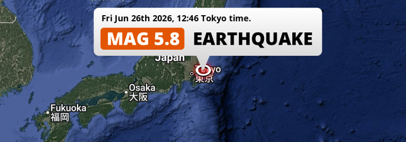
A significant Magnitude 5.8 earthquake struck under land 36 kilometer from Chiba in Japan in the early afternoon of Friday June 26th, 2026. The earthquake struck near a very densely populated region. Shaking may have been felt by a total of 47 million people.
Felt the earthquake? Share this article: 


Earthquake Summary
The earthquake struck on land in Japan, 36 kilometer (22 mi) east of Chiba. The center of this earthquake had a quite shallow depth of 43 km. Shallow earthquakes usually have a larger impact than earthquakes deep in the earth.
| Date and Time: | Jun 26, 2026 12:46 (Tokyo Time) - Jun 26, 2026 03:46 Universal Time. |
|---|---|
| Location: | 36 km east of Chiba, Japan. Coordinates 35°37'53"N 140°30'36"E. |
| Map: | 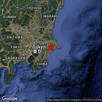 Map of area around epicenter. Click to open in Google Maps. |
| Magnitude: | MAG 5.8 Detected by 37 stations. Maximum Error Range ±0.051 . |
| Depth: | 43 km (27 mi) A quite shallow depth. |
| Max. Intensity: | V
Moderate On the Modified Mercalli Scale. |
| Tsunami Risk: | Tsunami very unlikely While this was a shallow earthquake in a coastal area, it appears to have occurred under land (4 km from the sea) with a magnitude that is usually not strong enough to cause tsunami's. Always stay cautious - More info here. |
Minimal impact predicted
Based on scientific estimates by the US Geographic Survey (USGS), the risk of high fatalities for this earthquake is classified at level GREEN (low). They expect an 90% likelyhood of between 0 and 1 fatalities.
The USGS classifies the economic impact of this earthquake at level GREEN (low). They expect an 90% likelyhood of between 0 and 1 million US Dollars in economic damage and impact.
Roughly 47 million people exposed to shaking
An estimated 47 million have been exposed to shaking (An MMI or Modified Mercalli Intensity level II or higher) as a result of this earthquake according scientific estimates published by the USGS.
Light shaking and likely no damage may have been experienced by an estimated 28,650,000 people. At IV, it is the highest MMI level this earthquake has caused. All exposure to shaking was within the borders of Japan .
| People | MMI Level | Shaking | Damage |
|---|---|---|---|
| 0 | I |
Not noticable | None |
| 109,500 | II |
Very weak | None |
| 17,830,000 | III |
Weak | Probably none |
| 28,650,000 | IV |
Light | Likely none |
| 0 | V |
Moderate | Very light |
| 0 | VI |
Strong | Light |
| 0 | VII |
Very Strong | Moderate |
| 0 | VIII |
Severe | Moderate to heavy |
| 0 | IX |
Violent | Heavy |
| 0 | X |
Extreme | Very heavy |
Nearby towns and cities
This earthquake may have been felt in Japan . The closest significant population center near the earthquake is Yōkaichiba in Chiba, Japan. Yōkaichiba is located 8 kilometer (5 mi) southwest of the epicenter. Yōkaichiba experienced an earthquake intensity (MMI Scale) of roughly IV. That level implies light shaking and likely no damage.
Major cities near this earthquake: Tokyo is located 74 km to the west and experienced an intensity of IV (light shaking, likely no damage). Yokohama is located 81 km to the west and experienced an intensity of III (weak shaking, probably no damage). Chiba is located 36 km to the west and experienced an intensity of IV (light shaking, likely no damage).
The table below provides an overview of all places in proximity of today's earthquake. Where available, the estimated intensity on the Modified Mercalli Intensity Scale in each place is included. Places where this information is omitted likely experienced little impact.
Overview of nearby places
| Distance | Place | Intensity (MMI) |
|---|---|---|
| 8 km (5 mi) NE from epicenter |
Yōkaichiba Chiba, Japan. |
IV
Light |
| 9 km (6 mi) SW from epicenter |
Narutō Chiba, Japan. |
IV
Light |
| 16 km (10 mi) SW from epicenter |
Tōgane Chiba, Japan. |
IV
Light |
| 16 km (10 mi) NE from epicenter |
Asahi Chiba, Japan. |
IV
Light |
| 18 km (11 mi) W from epicenter |
Yachimata Chiba, Japan. |
IV
Light |
| 22 km (14 mi) SW from epicenter |
Ōami Chiba, Japan. |
IV
Light |
| 24 km (15 mi) NW from epicenter |
Shisui Chiba, Japan. |
IV
Light |
| 24 km (15 mi) NW from epicenter |
Narita Chiba, Japan. |
IV
Light |
| 26 km (16 mi) N from epicenter |
Omigawa Chiba, Japan. |
IV
Light |
| 27 km (17 mi) W from epicenter |
Sakura Chiba, Japan. |
IV
Light |
| 28 km (17 mi) N from epicenter |
Sawara Chiba, Japan. |
IV
Light |
| 30 km (19 mi) N from epicenter |
Katori-shi Chiba, Japan. |
IV
Light |
| 30 km (19 mi) SW from epicenter |
Mobara Chiba, Japan. |
IV
Light |
| 31 km (19 mi) E from epicenter |
Hasaki Chiba, Japan. |
IV
Light |
| 31 km (19 mi) W from epicenter |
Yotsukaidō Chiba, Japan. |
IV
Light |
| 36 km (22 mi) W from epicenter |
Chiba Chiba, Japan. |
IV
Light |
| 39 km (24 mi) N from epicenter |
Kashima-shi Ibaraki, Japan. |
IV
Light |
| 40 km (25 mi) NW from epicenter |
Inashiki Ibaraki, Japan. |
IV
Light |
| 41 km (25 mi) W from epicenter |
Ichihara Chiba, Japan. |
IV
Light |
| 42 km (26 mi) NW from epicenter |
Ryūgasaki Ibaraki, Japan. |
IV
Light |
| 44 km (27 mi) NW from epicenter |
Shiroi Chiba, Japan. |
IV
Light |
| 48 km (30 mi) W from epicenter |
Honchō Chiba, Japan. |
IV
Light |
| 49 km (30 mi) NW from epicenter |
Toride Ibaraki, Japan. |
IV
Light |
| 50 km (31 mi) NW from epicenter |
Ushiku Ibaraki, Japan. |
IV
Light |
| 52 km (32 mi) NW from epicenter |
Abiko Chiba, Japan. |
IV
Light |
| 54 km (34 mi) NW from epicenter |
Kashiwa Chiba, Japan. |
IV
Light |
| 56 km (35 mi) W from epicenter |
Urayasu Tokyo, Japan. |
IV
Light |
| 57 km (35 mi) W from epicenter |
Matsudo Chiba, Japan. |
IV
Light |
| 59 km (37 mi) SW from epicenter |
Kisarazu Chiba, Japan. |
IV
Light |
| 60 km (37 mi) NW from epicenter |
Nagareyama Chiba, Japan. |
IV
Light |
| 68 km (42 mi) W from epicenter |
Sōka Saitama, Japan. |
IV
Light |
| 68 km (42 mi) NW from epicenter |
Noda Chiba, Japan. |
IV
Light |
| 71 km (44 mi) NW from epicenter |
Koshigaya Saitama, Japan. |
IV
Light |
| 73 km (45 mi) NW from epicenter |
Tsukuba Ibaraki, Japan. |
IV
Light |
| 73 km (45 mi) W from epicenter |
Kawasaki Kanagawa, Japan. |
IV
Light |
| 74 km (46 mi) W from epicenter |
Tokyo Tokyo, Japan. |
IV
Light |
| 75 km (47 mi) W from epicenter |
Kawaguchi Saitama, Japan. |
IV
Light |
| 79 km (49 mi) NW from epicenter |
Kasukabe Saitama, Japan. |
IV
Light |
| 80 km (50 mi) N from epicenter |
Mito Ibaraki, Japan. |
IV
Light |
| 81 km (50 mi) W from epicenter |
Yokohama Kanagawa, Japan. |
III
Weak |
| 83 km (52 mi) W from epicenter |
Saitama Saitama, Japan. |
IV
Light |
| 86 km (53 mi) SW from epicenter |
Yokosuka Kanagawa, Japan. |
III
Weak |
| 87 km (54 mi) W from epicenter |
Chōfu Tokyo, Japan. |
IV
Light |
| 87 km (54 mi) W from epicenter |
Kamirenjaku Tokyo, Japan. |
IV
Light |
| 88 km (55 mi) W from epicenter |
Nishi-Tokyo-shi Tokyo, Japan. |
IV
Light |
| 89 km (55 mi) NW from epicenter |
Ageoshimo Saitama, Japan. |
IV
Light |
| 96 km (60 mi) W from epicenter |
Tokorozawa Saitama, Japan. |
IV
Light |
| 96 km (60 mi) W from epicenter |
Machida Tokyo, Japan. |
III
Weak |
| 97 km (60 mi) W from epicenter |
Kawagoe Saitama, Japan. |
IV
Light |
| 98 km (61 mi) NW from epicenter |
Oyama Tochigi, Japan. |
IV
Light |
| 98 km (61 mi) W from epicenter |
Minamirinkan Kanagawa, Japan. |
III
Weak |
| 99 km (62 mi) W from epicenter |
Fujisawa Kanagawa, Japan. |
III
Weak |
| 154 km (96 mi) NW from epicenter |
Maebashi Gunma, Japan. |
III
Weak |
| 161 km (100 mi) N from epicenter |
Iwaki Fukushima, Japan. |
III
Weak |
| 173 km (107 mi) W from epicenter |
Fuji Shizuoka, Japan. |
III
Weak |
| 176 km (109 mi) W from epicenter |
Kōfu Yamanashi, Japan. |
III
Weak |
| 238 km (148 mi) NW from epicenter |
Nagano Nagano, Japan. |
|
| 284 km (176 mi) NW from epicenter |
Niigata Niigata, Japan. |
|
| 290 km (180 mi) N from epicenter |
Yamagata Yamagata, Japan. |
|
| 295 km (183 mi) N from epicenter |
Sendai Miyagi, Japan. |
|
| 319 km (198 mi) W from epicenter |
Toyama Toyama, Japan. |
|
| 330 km (205 mi) W from epicenter |
Nagoya Aichi, Japan. |
|
| 340 km (211 mi) W from epicenter |
Gifu-shi Gifu, Japan. |
|
| 361 km (224 mi) W from epicenter |
Yokkaichi Mie, Japan. |
|
| 366 km (227 mi) W from epicenter |
Kanazawa Ishikawa, Japan. |
|
| 369 km (229 mi) N from epicenter |
Ichinoseki Iwate, Japan. |
|
| 388 km (241 mi) W from epicenter |
Hikone Shiga, Japan. |
|
| 389 km (242 mi) W from epicenter |
Fukui-shi Fukui, Japan. |
|
| 393 km (244 mi) N from epicenter |
Yuzawa Akita, Japan. |
Earthquake Intensity Map
The intensity in shaking and damage by this earthquake is illustrated through the map below. The highest intensity measured for this earthquake is IV.

Shaking reported by 65 people
People that feel an earthquake may report their experience to the US Geographic Survey. Currently, 65 people have reported shaking in 27 places, all within Japan.We keep updating this article as more ground reports become available. You may report that you felt this earthquake here.
Places with most reports:
- Tokyo, Tokio, Japan: 25 people.
- Yokohama, Kanagawa, Japan: 6 people.
- Kawasaki, Kanagawa, Japan: 5 people.
- Yokosuka, Kanagawa, Japan: 3 people.
- Utsunomiya, Tochigi, Japan: 2 people.
- Naka, Ibaraki, Japan: 2 people.
- Urayasu, Chiba, Japan: 2 people.
- Yachimata, Chiba, Japan: 1 person.
- Inagi, Tokio, Japan: 1 person.
- Kokubunji, Tokio, Japan: 1 person.
7 Aftershocks detected
After this earthquake struck, 7 smaller aftershocks occurred. A 4.2 magnitude earthquake hit 15 hrs later 42 km (26 mi) west of this earthquake.
In the days before this main shock, 1 smaller foreshock was detected. Nearby this earthquake a foreshock struck 58 mins earlier. It measured a magnitude of 4.5
Overview of foreshocks and aftershocks
| Classification | Magnitude | When | Where |
|---|---|---|---|
| Foreshock | M 4.5 |
58 mins earlier Jun 26, 2026 11:48 (Tokyo Time) | 66 km (41 mi) NW from Main Shock. |
| Main Shock This Earthquake |
M 5.8 |
Jun 26, 2026 12:46 (Tokyo Time) | - |
| Aftershock | M 3.1 |
6 mins later Jun 26, 2026 12:52 (Tokyo Time) | 11 km (7 mi) NE from Main Shock. |
| Aftershock | M 3.9 |
14 mins later Jun 26, 2026 13:00 (Tokyo Time) | 11 km (7 mi) NE from Main Shock. |
| Aftershock | M 3.5 |
36 mins later Jun 26, 2026 13:22 (Tokyo Time) | 11 km (7 mi) NE from Main Shock. |
| Aftershock | M 4.1 |
45 mins later Jun 26, 2026 13:31 (Tokyo Time) | 24 km (15 mi) E from Main Shock. |
| Aftershock | M 4.2 |
15 hrs later Jun 27, 2026 03:59 (Tokyo Time) | 42 km (26 mi) W from Main Shock. |
| Aftershock | M 3.2 |
16 hrs later Jun 27, 2026 04:30 (Tokyo Time) | 78 km (49 mi) NW from Main Shock. |
| Aftershock | M 3.2 |
2 days later Jun 29, 2026 00:19 (Tokyo Time) | 70 km (43 mi) NW from Main Shock. |
More earthquakes coming?
Aftershocks are usually at least 1 order of magnitude less strong than main shocks. The more time passes, the smaller the chance and likely strength of any potential aftershocks.
It's always adviced to be cautious of the risk of a larger shock following any significant earthquake, however this risk is fairly small. There is a roughly 94 percent change that no larger main shock will follow in the days following this earthquake.
Read: How to Stay Safe during an Earthquake (cdc.gov).Earthquakes like this happen often in the region
Earthquakes of this strength are very common in the region. This is the strongest earthquake to hit since October 4th, 2025, when a 5.9 magnitude earthquake hit 220 km (137 mi) further north-east. An even stronger magnitude 7.3 earthquake struck on March 16th, 2022.
In total, 21 earthquakes with a magnitude of 5.8 or higher have been registered within 300km (186 mi) of this epicenter in the past 10 years. This comes down to an average of once every 6 months.
Tsunami very unlikely
While MAG-6.5+ earthquakes may cause tsunami's, it appears that the epicenter of this earthquake hit under land. In addition, the reported depth is deeper than 100km, making the risk of a tsunami even less likely. However always stay cautious and monitor advice from local authorities.
Tsunami Risk Factors
| Factor | Under Sea? | MAG-6.5 or stronger? | Shallow depth? |
|---|---|---|---|
| Explanation | Almost all tsunami's are caused by earthquakes with their epicenter under sea or very near the sea. However stay cautious in coastal areas as earthquakes on land may cause landslides into sea, potentially still causing a local tsunami. | Under MAG 6.5: Very unlikely to cause a tsunami. MAG 6.5 to 7.5: Destructive tsunami's do occur, but are uncommon. Likely to observe small sea level changes. MAG 7.6+: Earthquakes with these magnitudes might produce destructive tsunami's. |
Most destructive tsunami's are caused by shallow earthquakes with a depth between 0 and 100km under the surface of the earth. Deeper tsunami's are unlikely to displace to ocean floor. |
| This Earthquake | This earthquake appears to have struck on land near a coastal area (4 km from the sea). | Not this earthquake. This earthquake had a magnitude of 5.8. Earthquakes of this strength are unlikely to trigger a tsunami. |
This earthquake occurred at a depth of of 43 km (27 mi). Earthquakes this shallow could trigger a tsunami. |
Sources
Last updated 21/07/26 06:38 (). This article is automatically generated based on available data. We keep checking multiple sources for additional information. This article gets updated as new details on this earthquake become available.
- US Geographic Society (USGS): Earthquake us6000t8cy
- European-Mediterranean Seismological Centre (EMSC): Earthquake 20260626_0000042
- Geonames.org: World Cities Database
- Google Maps: Static API
- Earthquakelist.org: Historic Earthquakes Database
Share this article:
