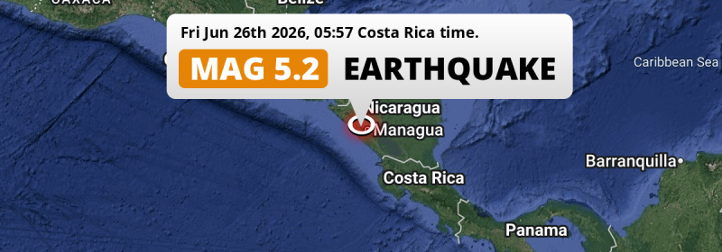
A significant M5.2 earthquake struck under land 25 kilometer from Managua in Nicaragua in the early morning of Friday June 26th, 2026. Other countries near the epicenter include Honduras, Costa Rica and El Salvador.
Felt the earthquake? Share this article: 


Earthquake Summary
The earthquake struck on land in Nicaragua, 25 kilometer (16 mi) southwest of Managua. The center of this earthquake had an intermediate depth of 121 km.
| Date and Time: | Jun 26, 2026 05:57AM (Managua Time) - Jun 26, 2026 11:57 Universal Time. |
|---|---|
| Location: | 25 km SW of Managua, Nicaragua. Coordinates 12°1'52"N 86°27'23"W. |
| Map: | 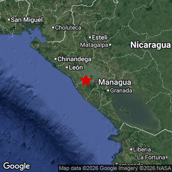 Map of area around epicenter. Click to open in Google Maps. |
| Magnitude: | MAG 5.2 Detected by 23 stations. Maximum Error Range ±0.065 . |
| Depth: | 121 km (75 mi) An intermediate depth. |
| Tsunami Risk: | Tsunami very unlikely Tsunami's are usually caused by MAG-6.5+ earthquakes, less than 100km shallow, and with an epicenter under sea. Neither of this seems to be the case. Always stay cautious - More info here. |
Nearby towns and cities
Nicaragua , Honduras , Costa Rica and El Salvador are all located within 300km distance of the epicenter of the earthquake.
The closest significant population center near the earthquake is El Crucero in Managua, Nicaragua. El Crucero is located 17 kilometer (11 mi) west of the epicenter.
Multiple large cities are in proximity of today's earthquake. Managua is located 25 km to the north-east. Tegucigalpa is located 242 km to the north. Masaya is located 40 km to the east.
The table below provides an overview of all places in proximity of today's earthquake.
Overview of nearby places
| Distance | Place |
|---|---|
| 17 km (11 mi) E from epicenter |
El Crucero Managua, Nicaragua. |
| 19 km (12 mi) NE from epicenter |
Ciudad Sandino Managua, Nicaragua. |
| 20 km (12 mi) S from epicenter |
San Rafael del Sur Managua, Nicaragua. |
| 25 km (16 mi) NE from epicenter |
Managua Managua, Nicaragua. |
| 29 km (18 mi) NW from epicenter |
Nagarote León, Nicaragua. |
| 30 km (19 mi) SE from epicenter |
Diriamba Carazo, Nicaragua. |
| 31 km (19 mi) SE from epicenter |
San Marcos Carazo, Nicaragua. |
| 35 km (22 mi) SE from epicenter |
Jinotepe Carazo, Nicaragua. |
| 36 km (22 mi) E from epicenter |
Masatepe Masaya, Nicaragua. |
| 40 km (25 mi) E from epicenter |
Masaya Masaya, Nicaragua. |
| 42 km (26 mi) NW from epicenter |
La Paz Centro León, Nicaragua. |
| 43 km (27 mi) NE from epicenter |
Tipitapa Managua, Nicaragua. |
| 53 km (33 mi) SE from epicenter |
Nandaime Granada, Nicaragua. |
| 56 km (35 mi) E from epicenter |
Granada Granada, Nicaragua. |
| 64 km (40 mi) NW from epicenter |
León León, Nicaragua. |
| 87 km (54 mi) NW from epicenter |
Chichigalpa Chinandega, Nicaragua. |
| 93 km (58 mi) NW from epicenter |
Corinto Chinandega, Nicaragua. |
| 95 km (59 mi) SE from epicenter |
Rivas Rivas, Nicaragua. |
| 99 km (62 mi) NW from epicenter |
Chinandega Chinandega, Nicaragua. |
| 100 km (62 mi) NE from epicenter |
Boaco Boaco, Nicaragua. |
| 104 km (65 mi) NW from epicenter |
El Viejo Chinandega, Nicaragua. |
| 110 km (68 mi) E from epicenter |
Camoapa Boaco, Nicaragua. |
| 115 km (71 mi) NE from epicenter |
Matagalpa Matagalpa, Nicaragua. |
| 118 km (73 mi) N from epicenter |
Estelí Estelí, Nicaragua. |
| 119 km (74 mi) E from epicenter |
Juigalpa Chontales, Nicaragua. |
| 123 km (76 mi) NW from epicenter |
Somotillo Chinandega, Nicaragua. |
| 128 km (80 mi) N from epicenter |
Jinotega Jinotega, Nicaragua. |
| 162 km (101 mi) N from epicenter |
Somoto Madriz, Nicaragua. |
| 162 km (101 mi) NW from epicenter |
Ciudad Choluteca Choluteca, Honduras. |
| 167 km (104 mi) NE from epicenter |
Río Blanco Matagalpa, Nicaragua. |
| 178 km (111 mi) N from epicenter |
Ocotal Nueva Segovia, Nicaragua. |
| 187 km (116 mi) SE from epicenter |
San José Alajuela, Costa Rica. |
| 189 km (117 mi) NW from epicenter |
San Lorenzo Valle, Honduras. |
| 191 km (119 mi) SE from epicenter |
Liberia Guanacaste, Costa Rica. |
| 204 km (127 mi) N from epicenter |
El Paraíso El Paraíso, Honduras. |
| 209 km (130 mi) NW from epicenter |
La Unión La Unión, El Salvador. |
| 213 km (132 mi) N from epicenter |
Jalapa Nueva Segovia, Nicaragua. |
| 221 km (137 mi) E from epicenter |
Nueva Guinea South Caribbean Coast, Nicaragua. |
| 223 km (139 mi) N from epicenter |
Danlí El Paraíso, Honduras. |
| 232 km (144 mi) SE from epicenter |
Cañas Guanacaste, Costa Rica. |
| 242 km (150 mi) N from epicenter |
Tegucigalpa Francisco Morazán, Honduras. |
| 244 km (152 mi) E from epicenter |
Rama South Caribbean Coast, Nicaragua. |
| 247 km (153 mi) NW from epicenter |
San Miguel San Miguel, El Salvador. |
| 255 km (158 mi) NW from epicenter |
San Rafael Oriente San Miguel, El Salvador. |
| 257 km (160 mi) NW from epicenter |
San Francisco Morazán, El Salvador. |
| 261 km (162 mi) NW from epicenter |
Usulután Usulután, El Salvador. |
| 263 km (163 mi) NE from epicenter |
Siuna North Caribbean Coast, Nicaragua. |
| 287 km (178 mi) NW from epicenter |
La Paz La Paz, Honduras. |
| 289 km (180 mi) SE from epicenter |
Puntarenas Puntarenas, Costa Rica. |
| 291 km (181 mi) SE from epicenter |
Quesada Alajuela, Costa Rica. |
| 292 km (181 mi) SE from epicenter |
Chacarita Puntarenas, Costa Rica. |
| 293 km (182 mi) E from epicenter |
Bluefields South Caribbean Coast, Nicaragua. |
| 294 km (183 mi) N from epicenter |
Juticalpa Olancho, Honduras. |
| 298 km (185 mi) NW from epicenter |
Comayagua Comayagua, Honduras. |
Shaking reported by 11 people in 3 countries
People that feel an earthquake may report their experience to the US Geographic Survey. Currently, 11 people have reported shaking in 6 places in 3 countries (Nicaragua, Costa Rica, El Salvador).We keep updating this article as more ground reports become available. You may report that you felt this earthquake here.
Places with most reports:
- Managua, Managua, Nicaragua: 4 people.
- Santa Cruz, Guanacaste, Costa Rica: 2 people.
- Tola, Rivas, Nicaragua: 2 people.
- Masatepe, Carazo, Nicaragua: 1 person.
- Diriamba, Carazo, Nicaragua: 1 person.
- Ayutuxtepeque, San Salvador, El Salvador: 1 person.
Aftershocks detected
This main shock was followed by 1 smaller aftershock. At a distance of 94 km (58 mi) south of this earthquake, an aftershock struck 7 hrs later. It measured a magnitude of 2.9
This main shock was prefaced by 3 smaller foreshocks. Roughly 2 days before this earthquake, a foreshock measuring MAG-3.4 was detected nearby this earthquake.
Overview of foreshocks and aftershocks
| Classification | Magnitude | When | Where |
|---|---|---|---|
| Foreshock | M 2.7 |
3 days earlier Jun 23, 2026 01:45PM (Managua Time) | 99 km (62 mi) W from Main Shock. |
| Foreshock | M 3.4 |
2 days earlier Jun 24, 2026 04:25PM (Managua Time) | 87 km (54 mi) W from Main Shock. |
| Foreshock | M 2.9 |
1 day earlier Jun 24, 2026 09:40PM (Managua Time) | 98 km (61 mi) SW from Main Shock. |
| Main Shock This Earthquake |
M 5.2 |
Jun 26, 2026 05:57AM (Managua Time) | - |
| Aftershock | M 2.9 |
7 hrs later Jun 26, 2026 12:48PM (Managua Time) | 94 km (58 mi) S from Main Shock. |
More earthquakes coming?
Aftershocks are usually at least 1 order of magnitude less strong than main shocks. The more time passes, the smaller the chance and likely strength of any potential aftershocks.
The chance that a significant earthquake like this one is followed by an even larger earthquake is not so large. On average, scientists estimate a 94% chance that a major earthquake will not be followed by an even larger one. It is still adviced to be aware of this risk
Read: How to Stay Safe during an Earthquake (cdc.gov).Earthquakes like this happen often in the region
Earthquakes of this strength are very common in the region. This is the strongest earthquake to hit since April 15th, 2026, when a 5.7 magnitude earthquake hit 238 km (148 mi) further south. An even stronger magnitude 6.9 earthquake struck on November 24th, 2016.
In total, 47 earthquakes with a magnitude of 5.2 or higher have been registered within 300km (186 mi) of this epicenter in the past 10 years. This comes down to an average of once every 3 months.
Tsunami very unlikely
It is very unlikely that this eartquake will cause any tsunami's. The reported magnitude is lower than the MAG-6.5 strength required to cause any earthquakes. In addition, this earthquake was not very shallow and appears to have occurred under land. However always stay cautious and monitor advice from local authorities.
Tsunami Risk Factors
| Factor | Under Sea? | MAG-6.5 or stronger? | Shallow depth? |
|---|---|---|---|
| Explanation | Almost all tsunami's are caused by earthquakes with their epicenter under sea or very near the sea. However stay cautious in coastal areas as earthquakes on land may cause landslides into sea, potentially still causing a local tsunami. | Under MAG 6.5: Very unlikely to cause a tsunami. MAG 6.5 to 7.5: Destructive tsunami's do occur, but are uncommon. Likely to observe small sea level changes. MAG 7.6+: Earthquakes with these magnitudes might produce destructive tsunami's. |
Most destructive tsunami's are caused by shallow earthquakes with a depth between 0 and 100km under the surface of the earth. Deeper tsunami's are unlikely to displace to ocean floor. |
| This Earthquake | This earthquake appears to have struck on land near a coastal area (21 km from the sea). | Not this earthquake. This earthquake had a magnitude of 5.2. Earthquakes of this strength are unlikely to trigger a tsunami. |
Not this earthquake. This earthquake occurred at a depth of 121 km (75 mi). Earthquakes this deep in the earth are unlikely to trigger a tsunami. |
Sources
Last updated 20/07/26 14:28 (). As more information on this earthquake becomes available this article will be updated. This article is automatically composed based on data originating from multiple sources.
- US Geographic Society (USGS): Earthquake us6000t8ey
- European-Mediterranean Seismological Centre (EMSC): Earthquake 20260626_0000158
- Geonames.org: World Cities Database
- Google Maps: Static API
- Earthquakelist.org: Historic Earthquakes Database
Share this article:
