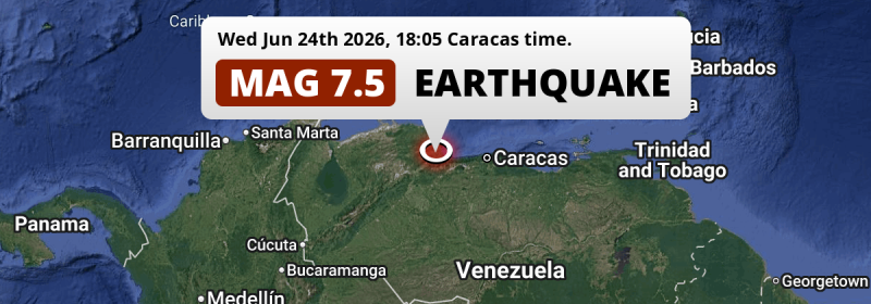
A DESTRUCTIVE and very strong Magnitude 7.5 earthquake struck under land 51 kilometer from Valencia in Venezuela in the evening of Wednesday June 24th, 2026. The earthquake struck near a very densely populated region. Mag 6.5+ earthquakes at such shallow depth can cause tsunami's, but this earthquake hit under land. As it's epicenter is close to a coastal area, we still advice cautiousness. Another nearby country is Aruba.
Felt the earthquake? Share this article: 


Earthquake Summary
The earthquake struck on land in Venezuela, 51 kilometer (32 mi) northwest of Valencia in Carabobo. The center of this earthquake had a very shallow depth of 10 km. Shallow earthquakes usually have a larger impact than earthquakes deep in the earth.
| Date and Time: | Jun 24, 2026 06:05PM (Caracas Time) - Jun 24, 2026 22:05 Universal Time. |
|---|---|
| Location: | 51 km NW of Valencia, Carabobo, Venezuela. Coordinates 10°26'41"N 68°22'40"W. |
| Map: | 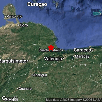 Map of area around epicenter. Click to open in Google Maps. |
| Magnitude: | MAG 7.5 Detected by 75 stations. Maximum Error Range ±0.036 . |
| Depth: | 10 km (6 mi) A very shallow depth. |
| Tsunami Risk: | Small Tsunami Risk Mag 6.5+ earthquakes at such shallow depth can cause tsunami's, but this earthquake hit under land. As it's epicenter is close to a coastal area, we still advice cautiousness. Always stay cautious - More info here. |
Small Tsunami Risk
There is a small tsunami risk following this earthquake, as it appears the epicenter was under land, 21 km from the coast. However this was a very strong earthquake at a shallow depth that would have a very high risk at causing tsunami's if it would have occurred under sea. Stay cautious and monitor advice from local authorities.
Tsunami Risk Factors
| Factor | Under Sea? | MAG-6.5 or stronger? | Shallow depth? |
|---|---|---|---|
| Explanation | Almost all tsunami's are caused by earthquakes with their epicenter under sea or very near the sea. However stay cautious in coastal areas as earthquakes on land may cause landslides into sea, potentially still causing a local tsunami. | Under MAG 6.5: Very unlikely to cause a tsunami. MAG 6.5 to 7.5: Destructive tsunami's do occur, but are uncommon. Likely to observe small sea level changes. MAG 7.6+: Earthquakes with these magnitudes might produce destructive tsunami's. |
Most destructive tsunami's are caused by shallow earthquakes with a depth between 0 and 100km under the surface of the earth. Deeper tsunami's are unlikely to displace to ocean floor. |
| This Earthquake | This earthquake appears to have struck on land near a coastal area (21 km from the sea). | This earthquake had a magnitude of 7.5. Earthquakes of this strength could trigger a tsunami. | This earthquake occurred at a depth of of 10 km (6 mi). Earthquakes this shallow could trigger a tsunami. |
High fatalities and economic impact
Based on scientific estimates by the US Geographic Survey (USGS), the risk of high fatalities for this earthquake is classified at level RED (high). They expect an 44% likelyhood of between 10,000 and 100,000 fatalities, and a 96% chance that the number of fatalities falls between 1,000 and 10,000,000.
The USGS classifies the economic impact of this earthquake at level RED (high). They expect an 54% likelyhood of between 10,000 and 100,000 million US Dollars in economic damage and impact, and a 100% chance that the economic impact of this earthquake falls between 1,000 and 10,000,000 million USD.
Roughly 33 million people exposed to shaking
This earthquake may have been felt by around 33 million people. That is the expected population size of the area exposed to a level of shaking of II or higher on the Modified Mercalli scale according to the USGS.
An estimated 16,220 people were exposed to level IX. At this level, violent shaking and likely heavy damage can be expected. The majority of people (roughly 12 million) live in an area exposed to level IV, where light shaking and likely no damage is expected.
People in 4 countries have been exposed to shaking. In Venezuela , around 31 million people, with impact levels up to IX (violent shaking, likely heavy damage). A smaller number of people were exposed in the following countries: Caribbean Netherlands, Colombia and Aruba.
| People | MMI Level | Shaking | Damage |
|---|---|---|---|
| 0 | I |
Not noticable | None |
| 0 | II |
Very weak | None |
| 4,883,000 | III |
Weak | Probably none |
| 11,650,000 | IV |
Light | Likely none |
| 4,820,000 | V |
Moderate | Very light |
| 3,764,000 | VI |
Strong | Light |
| 6,114,000 | VII |
Very Strong | Moderate |
| 1,329,000 | VIII |
Severe | Moderate to heavy |
| 16,220 | IX |
Violent | Heavy |
| 0 | X |
Extreme | Very heavy |
Nearby towns and cities
6 countries can be found within 300km of the epicenter of this earthquake: Venezuela and Aruba . Futher away, this earthquake may also have been felt in Colombia, Trinidad and Tobago and Grenada.
Located 20 kilometer (12 mi) west of the epicenter of this earthquake, Morón (Carabobo, Venezuela) is the nearest significant population center. Morón experienced an earthquake intensity (MMI Scale) of roughly VIII. That level implies severe shaking and likely moderate to heavy damage.
Multiple large cities are in proximity of today's earthquake. Valencia is located 51 km to the south-east and experienced an intensity of VII (very strong shaking, likely moderate damage). Maracay is located 89 km to the east and experienced an intensity of VII (very strong shaking, likely moderate damage). Caracas is located 164 km to the east and experienced an intensity of VII (very strong shaking, likely moderate damage).
A complete list of nearby places is included below. Estimated intensity data (MMI) sourced from a shake-map published by the US Geographic Survey is shown where available (cities without data probably experienced little impact).
Overview of nearby places
| Distance | Place | Intensity (MMI) |
|---|---|---|
| 20 km (12 mi) E from epicenter |
Morón Carabobo, Venezuela. |
VIII
Severe |
| 26 km (16 mi) S from epicenter |
Montalbán Carabobo, Venezuela. |
VI
Strong |
| 33 km (21 mi) SE from epicenter |
Bejuma Carabobo, Venezuela. |
VII
Very Strong |
| 33 km (21 mi) S from epicenter |
Miranda Carabobo, Venezuela. |
VII
Very Strong |
| 36 km (22 mi) NW from epicenter |
Yumare Yaracuy, Venezuela. |
VIII
Severe |
| 39 km (24 mi) SW from epicenter |
Nirgua Yaracuy, Venezuela. |
VII
Very Strong |
| 39 km (24 mi) N from epicenter |
Tucacas Falcón, Venezuela. |
VII
Very Strong |
| 40 km (25 mi) E from epicenter |
Puerto Cabello Carabobo, Venezuela. |
VIII
Severe |
| 42 km (26 mi) W from epicenter |
San Felipe Yaracuy, Venezuela. |
VIII
Severe |
| 46 km (29 mi) W from epicenter |
Cocorote Yaracuy, Venezuela. |
VII
Very Strong |
| 48 km (30 mi) SW from epicenter |
Boraure Yaracuy, Venezuela. |
VII
Very Strong |
| 51 km (32 mi) SE from epicenter |
Valencia Carabobo, Venezuela. |
VII
Very Strong |
| 52 km (32 mi) SW from epicenter |
Guama Yaracuy, Venezuela. |
VII
Very Strong |
| 57 km (35 mi) W from epicenter |
Aroa Yaracuy, Venezuela. |
VII
Very Strong |
| 59 km (37 mi) S from epicenter |
Tinaquillo Cojedes, Venezuela. |
VI
Strong |
| 60 km (37 mi) SE from epicenter |
Guacara Carabobo, Venezuela. |
VII
Very Strong |
| 64 km (40 mi) SE from epicenter |
Tacarigua Carabobo, Venezuela. |
VI
Strong |
| 65 km (40 mi) SW from epicenter |
Chivacoa Yaracuy, Venezuela. |
VI
Strong |
| 67 km (42 mi) E from epicenter |
San Joaquín Carabobo, Venezuela. |
VII
Very Strong |
| 74 km (46 mi) E from epicenter |
Mariara Carabobo, Venezuela. |
VI
Strong |
| 76 km (47 mi) SW from epicenter |
Urachiche Yaracuy, Venezuela. |
VI
Strong |
| 77 km (48 mi) SE from epicenter |
Güigüe Carabobo, Venezuela. |
VI
Strong |
| 81 km (50 mi) SW from epicenter |
Sabana de Parra Yaracuy, Venezuela. |
VI
Strong |
| 83 km (52 mi) E from epicenter |
El Limón Aragua, Venezuela. |
VII
Very Strong |
| 83 km (52 mi) S from epicenter |
Tinaco Cojedes, Venezuela. |
VI
Strong |
| 88 km (55 mi) W from epicenter |
Duaca Lara, Venezuela. |
VI
Strong |
| 89 km (55 mi) E from epicenter |
Maracay Aragua, Venezuela. |
VII
Very Strong |
| 90 km (56 mi) S from epicenter |
San Carlos Cojedes, Venezuela. |
VI
Strong |
| 91 km (57 mi) SW from epicenter |
Yaritagua Yaracuy, Venezuela. |
VI
Strong |
| 94 km (58 mi) S from epicenter |
El Pao Cojedes, Venezuela. |
VI
Strong |
| 96 km (60 mi) E from epicenter |
Palo Negro Aragua, Venezuela. |
VII
Very Strong |
| 102 km (63 mi) E from epicenter |
Turmero Aragua, Venezuela. |
VII
Very Strong |
| 104 km (65 mi) E from epicenter |
Cagua Aragua, Venezuela. |
VII
Very Strong |
| 105 km (65 mi) SW from epicenter |
Los Rastrojos Lara, Venezuela. |
V
Moderate |
| 107 km (66 mi) SE from epicenter |
Villa de Cura Aragua, Venezuela. |
VI
Strong |
| 107 km (66 mi) SW from epicenter |
Cabudare Lara, Venezuela. |
V
Moderate |
| 115 km (71 mi) W from epicenter |
Barquisimeto Lara, Venezuela. |
V
Moderate |
| 117 km (73 mi) E from epicenter |
La Victoria Aragua, Venezuela. |
VI
Strong |
| 127 km (79 mi) SE from epicenter |
San Juan de los Morros Guárico, Venezuela. |
VI
Strong |
| 133 km (83 mi) SW from epicenter |
Acarigua Portuguesa, Venezuela. |
V
Moderate |
| 135 km (84 mi) SW from epicenter |
Araure Portuguesa, Venezuela. |
V
Moderate |
| 146 km (91 mi) E from epicenter |
Los Teques Miranda, Venezuela. |
VI
Strong |
| 148 km (92 mi) E from epicenter |
Catia La Mar Estado La Guaira, Venezuela. |
VIII
Severe |
| 164 km (102 mi) E from epicenter |
Baruta Miranda, Venezuela. |
VII
Very Strong |
| 164 km (102 mi) E from epicenter |
Caracas Distrito Federal, Venezuela. |
VII
Very Strong |
| 167 km (104 mi) E from epicenter |
Cúa Miranda, Venezuela. |
VI
Strong |
| 172 km (107 mi) E from epicenter |
Petare Miranda, Venezuela. |
VII
Very Strong |
| 177 km (110 mi) NW from epicenter |
Coro Falcón, Venezuela. |
V
Moderate |
| 179 km (111 mi) E from epicenter |
Ocumare del Tuy Miranda, Venezuela. |
VI
Strong |
| 189 km (117 mi) E from epicenter |
Santa Teresa del Tuy Miranda, Venezuela. |
VI
Strong |
| 190 km (118 mi) N from epicenter |
Kralendijk Bonaire, Caribbean Netherlands. |
IV
Light |
| 192 km (119 mi) E from epicenter |
Guarenas Miranda, Venezuela. |
VII
Very Strong |
| 274 km (170 mi) SW from epicenter |
Valera Trujillo, Venezuela. |
IV
Light |
| 285 km (177 mi) SW from epicenter |
Barinas Barinas, Venezuela. |
IV
Light |
| 293 km (182 mi) NW from epicenter |
Oranjestad All regions, Aruba. |
IV
Light |
| 301 km (187 mi) S from epicenter |
San Fernando de Apure Apure, Venezuela. |
|
| 354 km (220 mi) W from epicenter |
Maracaibo Zulia, Venezuela. |
|
| 368 km (229 mi) SW from epicenter |
Mérida Mérida, Venezuela. |
|
| 405 km (252 mi) E from epicenter |
Barcelona Anzoátegui, Venezuela. |
|
| 434 km (270 mi) W from epicenter |
Maicao La Guajira, Colombia. |
|
| 456 km (283 mi) SW from epicenter |
Arauca Departamento de Arauca, Colombia. |
|
| 459 km (285 mi) E from epicenter |
Cumaná Sucre, Venezuela. |
|
| 496 km (308 mi) E from epicenter |
Porlamar Nueva Esparta, Venezuela. |
|
| 517 km (321 mi) SW from epicenter |
San Cristóbal Táchira, Venezuela. |
|
| 533 km (331 mi) W from epicenter |
Valledupar Cesar, Colombia. |
|
| 535 km (332 mi) SW from epicenter |
Cúcuta Norte de Santander, Colombia. |
|
| 539 km (335 mi) S from epicenter |
Puerto Ayacucho Amazonas, Venezuela. |
|
| 574 km (357 mi) E from epicenter |
Maturín Monagas, Venezuela. |
|
| 639 km (397 mi) SW from epicenter |
Bucaramanga Santander, Colombia. |
|
| 642 km (399 mi) W from epicenter |
Santa Marta Magdalena, Colombia. |
|
| 671 km (417 mi) E from epicenter |
Ciudad Guayana Bolivar, Venezuela. |
|
| 685 km (426 mi) S from epicenter |
Cumaribo Vichada, Colombia. |
|
| 702 km (436 mi) W from epicenter |
Barranquilla Atlántico, Colombia. |
|
| 710 km (441 mi) E from epicenter |
Tucupita Delta Amacuro, Venezuela. |
|
| 711 km (442 mi) W from epicenter |
Magangué Bolívar, Colombia. |
|
| 719 km (447 mi) W from epicenter |
Sucre Sucre, Colombia. |
|
| 720 km (447 mi) SW from epicenter |
Yopal Casanare, Colombia. |
|
| 727 km (452 mi) SW from epicenter |
Sogamoso Boyacá, Colombia. |
|
| 733 km (455 mi) E from epicenter |
Point Fortin Point Fortin, Trinidad and Tobago. |
|
| 744 km (462 mi) E from epicenter |
Saint George's Saint George, Grenada. |
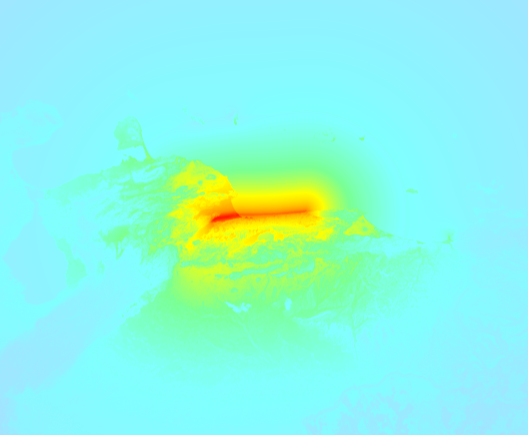
Earthquake Intensity Map
The maximum intensity (MMI Scale) caused by this earthquake is 0. The map below shows in which areas this earthquake was the most and least impactful. It is based on data from the US Geographic Survey.
Shaking reported by 649 people in 13 countries
People that feel an earthquake may report their experience to the US Geographic Survey. Currently, 649 people have reported shaking in 118 places in 13 countries (Venezuela, Colombia, Brazil, Netherlands Antilles, Bolivia, Dominican Republic, Guyana, Ecuador, Cuba, Aruba, Saint Lucia, Turks and Caicos Islands, Martinique).We keep updating this article as more ground reports become available. You may report that you felt this earthquake here.
Places with most reports:
- Chacao, Miranda, Venezuela: 97 people.
- Valencia, Carabobo, Venezuela: 37 people.
- Caracas, Distrito Capital, Venezuela: 36 people.
- Baruta, Miranda, Venezuela: 31 people.
- Barquisimeto, Lara, Venezuela: 24 people.
- Palo Negro, Aragua, Venezuela: 22 people.
- La Dolorita, Miranda, Venezuela: 22 people.
- Puerto la Cruz, Anzoátegui, Venezuela: 21 people.
- El Hatillo, Miranda, Venezuela: 20 people.
- El Cafetal, Miranda, Venezuela: 20 people.
4 Aftershocks detected
Since this main shock, 4 smaller aftershocks were detected. At a distance of 16 km (10 mi) northwest of this earthquake, an aftershock struck 1 sec later. It measured a magnitude of 7.5
This main shock was prefaced by 1 smaller foreshock. Roughly 37 sec before this earthquake, a foreshock measuring MAG-7.2 was detected nearby this earthquake.
Overview of foreshocks and aftershocks
| Classification | Magnitude | When | Where |
|---|---|---|---|
| Foreshock | M 7.2 |
37 sec earlier Jun 24, 2026 06:04PM (Caracas Time) | 20 km (12 mi) W from Main Shock. |
| Main Shock This Earthquake |
M 7.5 |
Jun 24, 2026 06:05PM (Caracas Time) | - |
| Aftershock | M 7.5 |
1 sec later Jun 24, 2026 06:05PM (Caracas Time) | 16 km (10 mi) NW from Main Shock. |
| Aftershock | M 4.4 |
1 day later Jun 26, 2026 12:19AM (Caracas Time) | 2.1 km (1.3 mi) NE from Main Shock. |
| Aftershock | M 4.7 |
2 days later Jun 26, 2026 06:16PM (Caracas Time) | 94 km (58 mi) NE from Main Shock. |
| Aftershock | M 4.8 |
3 days later Jun 27, 2026 03:20PM (Caracas Time) | 87 km (54 mi) E from Main Shock. |
More earthquakes coming?
Earthquakes can create aftershocks. These are generally at least 1 magnitude lower than any main shock, and as time passes the chance and strength of aftershocks decreases.
It's always adviced to be cautious of the risk of a larger shock following any significant earthquake, however this risk is fairly small. There is a roughly 94 percent change that no larger main shock will follow in the days following this earthquake.
Read: How to Stay Safe during an Earthquake (cdc.gov).This is an unusually powerful earthquake
No earthquake of this strength has struck this region for a long time. Our data goes back 10 years, and no earthquakes measuring a magnitude of 7.5 or higher have been detected within 300 km (186 mi) of this epicenter.
Sources
Last updated 21/07/26 02:38 (). This article is automatically generated based on available data. We keep checking multiple sources for additional information. This article gets updated as new details on this earthquake become available.
- European-Mediterranean Seismological Centre (EMSC): Earthquake 20260624_0000396
- Geonames.org: World Cities Database
- Google Maps: Static API
- Earthquakelist.org: Historic Earthquakes Database
Share this article:
