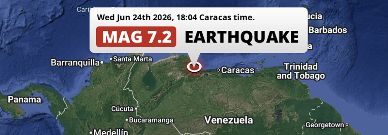
A DESTRUCTIVE and very strong Magnitude 7.2 foreshock struck under land 22 kilometer from San Felipe in Venezuela in the evening of Wednesday June 24th, 2026. The earthquake struck near a very densely populated region. Earthquakes this strong in locations like this are likely to cause a high number of fatalities and likely to have a large economic impact. Another country near the epicenter is Aruba.
Felt the earthquake? Share this article: 


Earthquake Summary
The earthquake struck on land in Venezuela, 22 kilometer (14 mi) east of San Felipe in Yaracuy. The center of this earthquake had a quite shallow depth of 28 km. Shallow earthquakes usually have a larger impact than earthquakes deep in the earth.
| Date and Time: | Jun 24, 2026 06:04PM (Caracas Time) - Jun 24, 2026 22:04 Universal Time. |
|---|---|
| Location: | 22 km east of San Felipe, Yaracuy, Venezuela. Coordinates 10°24'31"N 68°33'26"W. |
| Map: | 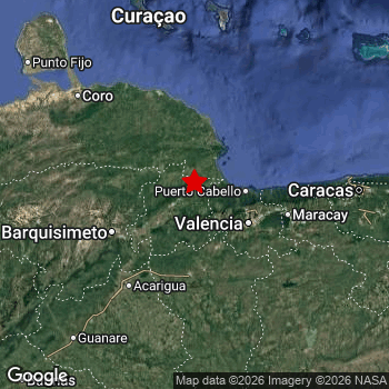 Map of area around epicenter. Click to open in Google Maps. |
| Magnitude: | MAG 7.2 Detected by 202 stations. Maximum Error Range ±0.058 . |
| Depth: | 28 km (17 mi) A quite shallow depth. |
| Max. Intensity: | IX
Violent On the Modified Mercalli Scale. |
| Tsunami Risk: | Low Tsunami Risk Mag 6.5+ earthquakes at shallow depth can cause tsunami's, but this epicenter appears to have hit under land, making this less likely. Always stay cautious - More info here. |
High fatalities and economic impact
Based on scientific estimates by the US Geographic Survey (USGS), the risk of high fatalities for this earthquake is classified at level RED (high). They expect an 41% likelyhood of between 10,000 and 100,000 fatalities, and a 91% chance that the number of fatalities falls between 1,000 and 10,000,000.
The USGS classifies the economic impact of this earthquake at level RED (high). They expect an 36% likelyhood of between 10,000 and 100,000 million US Dollars in economic damage and impact, and a 98% chance that the economic impact of this earthquake falls between 100 and 10,000,000 million USD.
Roughly 24 million people exposed to shaking
This earthquake may have been felt by around 24 million people. That is the expected population size of the area exposed to a level of shaking of II or higher on the Modified Mercalli scale according to the USGS.
Violent shaking and likely heavy damage may have been experienced by an estimated 36,300 people. At IX, it is the highest MMI level this earthquake has caused. Intensity level IV was experienced by the majority of people (around 12 million). In their region, light shaking and likely no damage can be expected.
People in 4 countries have been exposed to shaking. In Venezuela , around 24 million people, with impact levels up to IX (violent shaking, likely heavy damage). Other countries where people were exposed to shaking include Caribbean Netherlands, Aruba and Colombia.
| People | MMI Level | Shaking | Damage |
|---|---|---|---|
| 0 | I |
Not noticable | None |
| 0 | II |
Very weak | None |
| 655,000 | III |
Weak | Probably none |
| 12,300,000 | IV |
Light | Likely none |
| 4,708,000 | V |
Moderate | Very light |
| 5,251,000 | VI |
Strong | Light |
| 627,100 | VII |
Very Strong | Moderate |
| 332,400 | VIII |
Severe | Moderate to heavy |
| 36,300 | IX |
Violent | Heavy |
| 0 | X |
Extreme | Very heavy |
Nearby towns and cities
4 countries can be found within 300km of the epicenter of this earthquake: Venezuela and Aruba . Futher away, this earthquake may also have been felt in Colombia.
Located 22 kilometer (14 mi) east of the epicenter of this earthquake, San Felipe (Yaracuy, Venezuela) is the nearest significant population center. The intensity of shaking and damage in San Felipe is estimated to be around level VIII on the Modified Mercalli Intensity scale (severe shaking, likely moderate to heavy damage).
Multiple major population centers exist within 300km of the earthquake that struck today. Valencia is located 66 km to the south-east and experienced an intensity of VII (very strong shaking, likely moderate damage). Maracay is located 107 km to the east and experienced an intensity of VI (strong shaking, probably light damage). Caracas is located 184 km to the east and experienced an intensity of V (moderate shaking, very light damage).
A complete list of nearby places is included below. Estimated intensity data (MMI) sourced from a shake-map published by the US Geographic Survey is shown where available (cities without data probably experienced little impact).
Overview of nearby places
| Distance | Place | Intensity (MMI) |
|---|---|---|
| 22 km (14 mi) W from epicenter |
San Felipe Yaracuy, Venezuela. |
VIII
Severe |
| 25 km (16 mi) NW from epicenter |
Yumare Yaracuy, Venezuela. |
VII
Very Strong |
| 27 km (17 mi) W from epicenter |
Cocorote Yaracuy, Venezuela. |
VIII
Severe |
| 29 km (18 mi) S from epicenter |
Nirgua Yaracuy, Venezuela. |
VII
Very Strong |
| 29 km (18 mi) SW from epicenter |
Boraure Yaracuy, Venezuela. |
VIII
Severe |
| 33 km (21 mi) SW from epicenter |
Guama Yaracuy, Venezuela. |
VIII
Severe |
| 33 km (21 mi) SE from epicenter |
Montalbán Carabobo, Venezuela. |
VI
Strong |
| 34 km (21 mi) SE from epicenter |
Miranda Carabobo, Venezuela. |
VII
Very Strong |
| 37 km (23 mi) W from epicenter |
Aroa Yaracuy, Venezuela. |
VII
Very Strong |
| 40 km (25 mi) E from epicenter |
Morón Carabobo, Venezuela. |
VIII
Severe |
| 42 km (26 mi) SE from epicenter |
Bejuma Carabobo, Venezuela. |
VII
Very Strong |
| 46 km (29 mi) SW from epicenter |
Chivacoa Yaracuy, Venezuela. |
VII
Very Strong |
| 49 km (30 mi) NE from epicenter |
Tucacas Falcón, Venezuela. |
VII
Very Strong |
| 57 km (35 mi) SW from epicenter |
Urachiche Yaracuy, Venezuela. |
VII
Very Strong |
| 60 km (37 mi) E from epicenter |
Puerto Cabello Carabobo, Venezuela. |
VII
Very Strong |
| 61 km (38 mi) SW from epicenter |
Sabana de Parra Yaracuy, Venezuela. |
VII
Very Strong |
| 61 km (38 mi) SE from epicenter |
Tinaquillo Cojedes, Venezuela. |
VI
Strong |
| 66 km (41 mi) SE from epicenter |
Valencia Carabobo, Venezuela. |
VII
Very Strong |
| 68 km (42 mi) W from epicenter |
Duaca Lara, Venezuela. |
VII
Very Strong |
| 72 km (45 mi) SW from epicenter |
Yaritagua Yaracuy, Venezuela. |
VII
Very Strong |
| 77 km (48 mi) E from epicenter |
Guacara Carabobo, Venezuela. |
VI
Strong |
| 78 km (48 mi) SE from epicenter |
Tacarigua Carabobo, Venezuela. |
VI
Strong |
| 80 km (50 mi) S from epicenter |
Tinaco Cojedes, Venezuela. |
VI
Strong |
| 83 km (52 mi) S from epicenter |
San Carlos Cojedes, Venezuela. |
VI
Strong |
| 85 km (53 mi) E from epicenter |
San Joaquín Carabobo, Venezuela. |
VI
Strong |
| 86 km (53 mi) SW from epicenter |
Los Rastrojos Lara, Venezuela. |
VI
Strong |
| 88 km (55 mi) SW from epicenter |
Cabudare Lara, Venezuela. |
VI
Strong |
| 93 km (58 mi) SW from epicenter |
San Rafael de Onoto Portuguesa, Venezuela. |
VI
Strong |
| 93 km (58 mi) E from epicenter |
Güigüe Carabobo, Venezuela. |
VI
Strong |
| 93 km (58 mi) E from epicenter |
Mariara Carabobo, Venezuela. |
V
Moderate |
| 96 km (60 mi) SW from epicenter |
Barquisimeto Lara, Venezuela. |
VI
Strong |
| 97 km (60 mi) S from epicenter |
Las Vegas Cojedes, Venezuela. |
VI
Strong |
| 98 km (61 mi) SE from epicenter |
El Pao Cojedes, Venezuela. |
VI
Strong |
| 102 km (63 mi) E from epicenter |
El Limón Aragua, Venezuela. |
VI
Strong |
| 107 km (66 mi) E from epicenter |
Maracay Aragua, Venezuela. |
VI
Strong |
| 114 km (71 mi) E from epicenter |
Palo Negro Aragua, Venezuela. |
VI
Strong |
| 118 km (73 mi) SW from epicenter |
Acarigua Portuguesa, Venezuela. |
VI
Strong |
| 118 km (73 mi) SW from epicenter |
Araure Portuguesa, Venezuela. |
VI
Strong |
| 120 km (75 mi) E from epicenter |
Turmero Aragua, Venezuela. |
V
Moderate |
| 123 km (76 mi) E from epicenter |
Cagua Aragua, Venezuela. |
VI
Strong |
| 124 km (77 mi) E from epicenter |
Villa de Cura Aragua, Venezuela. |
V
Moderate |
| 136 km (85 mi) E from epicenter |
La Victoria Aragua, Venezuela. |
V
Moderate |
| 143 km (89 mi) E from epicenter |
San Juan de los Morros Guárico, Venezuela. |
V
Moderate |
| 165 km (103 mi) NW from epicenter |
Coro Falcón, Venezuela. |
V
Moderate |
| 166 km (103 mi) E from epicenter |
Los Teques Miranda, Venezuela. |
V
Moderate |
| 168 km (104 mi) E from epicenter |
Catia La Mar Estado La Guaira, Venezuela. |
V
Moderate |
| 169 km (105 mi) W from epicenter |
Carora Lara, Venezuela. |
V
Moderate |
| 184 km (114 mi) E from epicenter |
Caracas Distrito Federal, Venezuela. |
V
Moderate |
| 184 km (114 mi) E from epicenter |
Baruta Miranda, Venezuela. |
IV
Light |
| 185 km (115 mi) E from epicenter |
Cúa Miranda, Venezuela. |
V
Moderate |
| 191 km (119 mi) E from epicenter |
Petare Miranda, Venezuela. |
IV
Light |
| 196 km (122 mi) N from epicenter |
Kralendijk Bonaire, Caribbean Netherlands. |
V
Moderate |
| 200 km (124 mi) SW from epicenter |
Guanare Portuguesa, Venezuela. |
IV
Light |
| 255 km (158 mi) SW from epicenter |
Valera Trujillo, Venezuela. |
IV
Light |
| 269 km (167 mi) SW from epicenter |
Barinas Barinas, Venezuela. |
IV
Light |
| 285 km (177 mi) NW from epicenter |
Oranjestad All regions, Aruba. |
III
Weak |
| 305 km (190 mi) SE from epicenter |
San Fernando de Apure Apure, Venezuela. |
|
| 335 km (208 mi) W from epicenter |
Maracaibo Zulia, Venezuela. |
|
| 349 km (217 mi) SW from epicenter |
Mérida Mérida, Venezuela. |
|
| 416 km (258 mi) W from epicenter |
Maicao La Guajira, Colombia. |
|
| 425 km (264 mi) E from epicenter |
Barcelona Anzoátegui, Venezuela. |
|
| 442 km (275 mi) SW from epicenter |
Arauca Departamento de Arauca, Colombia. |
|
| 478 km (297 mi) E from epicenter |
Cumaná Sucre, Venezuela. |
|
| 498 km (309 mi) SW from epicenter |
San Cristóbal Táchira, Venezuela. |
|
| 514 km (319 mi) W from epicenter |
Valledupar Cesar, Colombia. |
|
| 516 km (321 mi) SW from epicenter |
Cúcuta Norte de Santander, Colombia. |
|
| 516 km (321 mi) E from epicenter |
Porlamar Nueva Esparta, Venezuela. |
|
| 539 km (335 mi) S from epicenter |
Puerto Ayacucho Amazonas, Venezuela. |
|
| 593 km (368 mi) E from epicenter |
Maturín Monagas, Venezuela. |
|
| 620 km (385 mi) SW from epicenter |
Bucaramanga Santander, Colombia. |
|
| 623 km (387 mi) W from epicenter |
Santa Marta Magdalena, Colombia. |
|
| 677 km (421 mi) S from epicenter |
Cumaribo Vichada, Colombia. |
|
| 683 km (424 mi) W from epicenter |
Barranquilla Atlántico, Colombia. |
|
| 688 km (428 mi) E from epicenter |
Ciudad Guayana Bolivar, Venezuela. |
|
| 691 km (429 mi) W from epicenter |
Magangué Bolívar, Colombia. |
|
| 705 km (438 mi) SW from epicenter |
Yopal Casanare, Colombia. |
|
| 710 km (441 mi) SW from epicenter |
Sogamoso Boyacá, Colombia. |
|
| 729 km (453 mi) E from epicenter |
Tucupita Delta Amacuro, Venezuela. |
|
| 742 km (461 mi) SW from epicenter |
San Carlos Antioquia, Colombia. |
|
| 748 km (465 mi) W from epicenter |
Corozal Sucre, Colombia. |
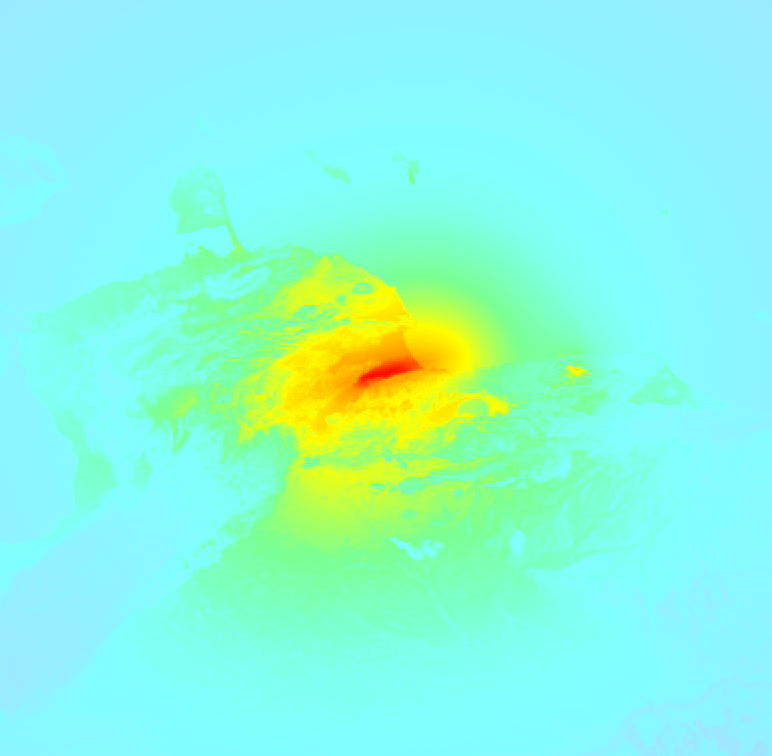
Earthquake Intensity Map
The maximum intensity (MMI Scale) caused by this earthquake is IX. The map below shows in which areas this earthquake was the most and least impactful. It is based on data from the US Geographic Survey.
Shaking reported by 14 people in 3 countries
People that feel an earthquake may report their experience to the US Geographic Survey. Currently, 14 people have reported shaking in 12 places in 3 countries (Venezuela, Martinique, Dominican Republic).We keep updating this article as more ground reports become available. You may report that you felt this earthquake here.
Places with most reports:
- Chacao, Miranda, Venezuela: 2 people.
- Caracas, Distrito Capital, Venezuela: 2 people.
- Valencia, Carabobo, Venezuela: 1 person.
- Cagua, Aragua, Venezuela: 1 person.
- Baruta, Miranda, Venezuela: 1 person.
- Ocumare del Tuy, Miranda, Venezuela: 1 person.
- El Hatillo, Miranda, Venezuela: 1 person.
- El Cafetal, Miranda, Venezuela: 1 person.
- San Antonio de los Altos, Miranda, Venezuela: 1 person.
- Saint-Joseph, Fort-de-France, Martinique: 1 person.
This is likely a foreshock
This earthquake was followed by a stronger MAG-7.5 earthquake, classifying this earthquake as a foreshock.
Overview of foreshocks and aftershocks
| Classification | Magnitude | When | Where |
|---|---|---|---|
| Foreshock This Earthquake |
M 7.2 |
37 sec earlier Jun 24, 2026 06:04PM (Caracas Time) | 20 km (12 mi) W from Main Shock. |
| Main Shock | M 7.5 |
Jun 24, 2026 06:05PM (Caracas Time) | - |
| Aftershock | M 7.5 |
1 sec later Jun 24, 2026 06:05PM (Caracas Time) | 16 km (10 mi) NW from Main Shock. |
| Aftershock | M 4.4 |
1 day later Jun 26, 2026 12:19AM (Caracas Time) | 2.1 km (1.3 mi) NE from Main Shock. |
| Aftershock | M 4.7 |
2 days later Jun 26, 2026 06:16PM (Caracas Time) | 94 km (58 mi) NE from Main Shock. |
| Aftershock | M 4.8 |
3 days later Jun 27, 2026 03:20PM (Caracas Time) | 87 km (54 mi) E from Main Shock. |
More earthquakes coming?
Earthquakes can create aftershocks. These are generally at least 1 magnitude lower than any main shock, and as time passes the chance and strength of aftershocks decreases.
The chance that a significant earthquake like this one is followed by an even larger earthquake is not so large. On average, scientists estimate a 94% chance that a major earthquake will not be followed by an even larger one. It is still adviced to be aware of this risk
Read: How to Stay Safe during an Earthquake (cdc.gov).This is an unusually powerful earthquake
No earthquake of this strength has struck this region for a long time. Our data goes back 10 years, and no earthquakes measuring a magnitude of 7.2 or higher have been detected within 300 km (186 mi) of this epicenter.
Low Tsunami Risk
There is a low tsunami risk following this earthquake, as it appears the epicenter was under land far away from the coast. However this was a very strong earthquake at a shallow depth that would have a very high risk at causing tsunami's if it would have occurred under sea. Stay cautious and monitor advice from local authorities.
Tsunami Risk Factors
| Factor | Under Sea? | MAG-6.5 or stronger? | Shallow depth? |
|---|---|---|---|
| Explanation | Almost all tsunami's are caused by earthquakes with their epicenter under sea or very near the sea. However stay cautious in coastal areas as earthquakes on land may cause landslides into sea, potentially still causing a local tsunami. | Under MAG 6.5: Very unlikely to cause a tsunami. MAG 6.5 to 7.5: Destructive tsunami's do occur, but are uncommon. Likely to observe small sea level changes. MAG 7.6+: Earthquakes with these magnitudes might produce destructive tsunami's. |
Most destructive tsunami's are caused by shallow earthquakes with a depth between 0 and 100km under the surface of the earth. Deeper tsunami's are unlikely to displace to ocean floor. |
| This Earthquake | Not this earthquake. This earthquake appears to have struck on land far from any coast. |
This earthquake had a magnitude of 7.2. Earthquakes of this strength could trigger a tsunami. | This earthquake occurred at a depth of of 28 km (17 mi). Earthquakes this shallow could trigger a tsunami. |
Sources
Last updated 21/07/26 02:18 (). As more information on this earthquake becomes available this article will be updated. This article is automatically composed based on data originating from multiple sources.
- US Geographic Society (USGS): Earthquake us6000t7zc
- Geonames.org: World Cities Database
- Google Maps: Static API
- Earthquakelist.org: Historic Earthquakes Database
Share this article:
