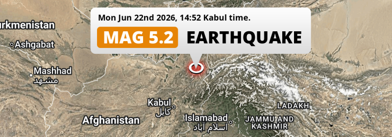
Under land 67 kilometer from Fayzabad in Afghanistan, a significant MAG-5.1 earthquake occurred in the afternoon of Monday June 22nd, 2026. Other nearby countries are Tajikistan and Pakistan.
Felt the earthquake? Share this article: 


Earthquake Summary
The earthquake struck on land in Afghanistan, 67 kilometer (42 mi) south of Fayzabad in Badakhshan. The center of this earthquake had an intermediate depth of 219 km.
| Date and Time: | Jun 22, 2026 02:52PM (Kabul Time) - Jun 22, 2026 10:22 Universal Time. |
|---|---|
| Location: | 67 km south of Fayzabad, Badakhshan, Afghanistan. Coordinates 36°31'37"N 70°43'42"E. |
| Map: | 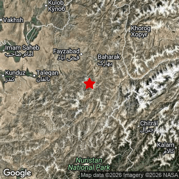 Map of area around epicenter. Click to open in Google Maps. |
| Magnitude: | MAG 5.1 Detected by 22 stations. Maximum Error Range ±0.066 . |
| Depth: | 219 km (136 mi) An intermediate depth. |
| Tsunami Risk: | Tsunami very unlikely Tsunami's are usually caused by MAG-6.5+ earthquakes, less than 100km shallow, and with an epicenter under sea. Neither of this seems to be the case. Always stay cautious - More info here. |
Nearby towns and cities
Afghanistan , Tajikistan and Pakistan are all located within 300km distance of the epicenter of the earthquake.
Located 67 kilometer (42 mi) south of the epicenter of this earthquake, Fayzabad (Badakhshan, Afghanistan) is the nearest significant population center.
Major cities near this earthquake: Kabul is located 263 km to the southwest. Peshawar is located 291 km to the south. Dushanbe is located 282 km to the northwest.
A complete list of nearby places is included below.
Overview of nearby places
| Distance | Place |
|---|---|
| 67 km (42 mi) N from epicenter |
Fayzabad Badakhshan, Afghanistan. |
| 82 km (51 mi) E from epicenter |
Ishqoshim Gorno-Badakhshan, Tajikistan. |
| 104 km (65 mi) NW from epicenter |
Rustāq Takhar, Afghanistan. |
| 109 km (68 mi) W from epicenter |
Taloqan Takhar, Afghanistan. |
| 127 km (79 mi) NW from epicenter |
Ārt Khwājah Takhar, Afghanistan. |
| 130 km (81 mi) NE from epicenter |
Khorugh Gorno-Badakhshan, Tajikistan. |
| 145 km (90 mi) W from epicenter |
Khanabad Kunduz, Afghanistan. |
| 151 km (94 mi) NW from epicenter |
Chubek Khatlon, Tajikistan. |
| 152 km (94 mi) W from epicenter |
Nahrīn Baghlan, Afghanistan. |
| 159 km (99 mi) NW from epicenter |
Farkhor Khatlon, Tajikistan. |
| 168 km (104 mi) W from epicenter |
Kunduz Kunduz, Afghanistan. |
| 172 km (107 mi) NW from epicenter |
Hulbuk Khatlon, Tajikistan. |
| 174 km (108 mi) SW from epicenter |
Bāzārak Panjshir, Afghanistan. |
| 175 km (109 mi) NW from epicenter |
Kŭlob Khatlon, Tajikistan. |
| 176 km (109 mi) S from epicenter |
Āsmār Kunar, Afghanistan. |
| 179 km (111 mi) SE from epicenter |
Thal Khyber Pakhtunkhwa, Pakistan. |
| 180 km (112 mi) SE from epicenter |
Upper Dir Khyber Pakhtunkhwa, Pakistan. |
| 186 km (116 mi) W from epicenter |
Baghlān Baghlan, Afghanistan. |
| 188 km (117 mi) S from epicenter |
Asadābād Kunar, Afghanistan. |
| 190 km (118 mi) NW from epicenter |
Qarāwul Kunduz, Afghanistan. |
| 192 km (119 mi) W from epicenter |
Pul-e Khumrī Baghlan, Afghanistan. |
| 206 km (128 mi) SW from epicenter |
Jabal os Saraj Parwan, Afghanistan. |
| 212 km (132 mi) S from epicenter |
Mehtar Lām Laghman, Afghanistan. |
| 213 km (132 mi) NW from epicenter |
Danghara Khatlon, Tajikistan. |
| 214 km (133 mi) NW from epicenter |
Vakhsh Khatlon, Tajikistan. |
| 218 km (135 mi) NW from epicenter |
Kolkhozobod Khatlon, Tajikistan. |
| 219 km (136 mi) SW from epicenter |
Charikar Parwan, Afghanistan. |
| 225 km (140 mi) NW from epicenter |
Moskovskiy Khatlon, Tajikistan. |
| 226 km (140 mi) NW from epicenter |
Bokhtar Khatlon, Tajikistan. |
| 235 km (146 mi) S from epicenter |
Jalālābād Nangarhar, Afghanistan. |
| 240 km (149 mi) SE from epicenter |
Bat Khela Khyber Pakhtunkhwa, Pakistan. |
| 241 km (150 mi) NW from epicenter |
Norak Khatlon, Tajikistan. |
| 244 km (152 mi) SE from epicenter |
Mingora Khyber Pakhtunkhwa, Pakistan. |
| 245 km (152 mi) W from epicenter |
Aībak Samangan, Afghanistan. |
| 249 km (155 mi) NW from epicenter |
Yovon Khatlon, Tajikistan. |
| 261 km (162 mi) S from epicenter |
Tangi Khyber Pakhtunkhwa, Pakistan. |
| 263 km (163 mi) SW from epicenter |
Kabul Kabul, Afghanistan. |
| 268 km (167 mi) S from epicenter |
Shabqadar Khyber Pakhtunkhwa, Pakistan. |
| 269 km (167 mi) SW from epicenter |
Paghmān Kabul, Afghanistan. |
| 271 km (168 mi) W from epicenter |
Khulm Balkh, Afghanistan. |
| 272 km (169 mi) NW from epicenter |
Vahdat Republican Subordination, Tajikistan. |
| 274 km (170 mi) NW from epicenter |
Boshkengash Dushanbe, Tajikistan. |
| 276 km (171 mi) S from epicenter |
Utmanzai Khyber Pakhtunkhwa, Pakistan. |
| 280 km (174 mi) S from epicenter |
Charsadda Khyber Pakhtunkhwa, Pakistan. |
| 282 km (175 mi) NW from epicenter |
Dushanbe Dushanbe, Tajikistan. |
| 285 km (177 mi) SE from epicenter |
Mardan Khyber Pakhtunkhwa, Pakistan. |
| 291 km (181 mi) S from epicenter |
Peshawar Khyber Pakhtunkhwa, Pakistan. |
| 292 km (181 mi) SE from epicenter |
Battagram Khyber Pakhtunkhwa, Pakistan. |
| 294 km (183 mi) NW from epicenter |
Hisor Republican Subordination, Tajikistan. |
| 296 km (184 mi) S from epicenter |
Pabbi Khyber Pakhtunkhwa, Pakistan. |
| 297 km (185 mi) SE from epicenter |
Risalpur Cantonment Khyber Pakhtunkhwa, Pakistan. |
Shaking reported by 1 person
People that feel an earthquake may report their experience to the US Geographic Survey. Currently, 1 person has reported shaking in one place in Pakistan.We keep updating this article as more ground reports become available. You may report that you felt this earthquake here.
Places with most reports:
- Abottabad, North-West Frontier, Pakistan: 1 person.
2 Aftershocks detected
Since this main shock, 2 smaller aftershocks were detected. At a distance of 35 km (21 mi) north-east of this earthquake, an aftershock struck 2 days later. It measured a magnitude of 4.6
In the days before this main shock, 1 smaller foreshock was detected. A 4.4 magnitude earthquake hit 1 day earlier nearby.
Overview of foreshocks and aftershocks
| Classification | Magnitude | When | Where |
|---|---|---|---|
| Foreshock | M 4.4 |
1 day earlier Jun 21, 2026 12:58PM (Kabul Time) | 28 km (17 mi) S from Main Shock. |
| Main Shock This Earthquake |
M 5.1 |
Jun 22, 2026 02:52PM (Kabul Time) | - |
| Aftershock | M 4.4 |
2 days later Jun 24, 2026 10:23PM (Kabul Time) | 30 km (18 mi) SW from Main Shock. |
| Aftershock | M 4.6 |
2 days later Jun 24, 2026 10:23PM (Kabul Time) | 35 km (21 mi) NE from Main Shock. |
More earthquakes coming?
Earthquakes can create aftershocks. These are generally at least 1 magnitude lower than any main shock, and as time passes the chance and strength of aftershocks decreases.
It's always adviced to be cautious of the risk of a larger shock following any significant earthquake, however this risk is fairly small. There is a roughly 94 percent change that no larger main shock will follow in the days following this earthquake.
Read: How to Stay Safe during an Earthquake (cdc.gov).Earthquakes like this happen often in the region
Earthquakes of this strength are very common in the region. This is the strongest earthquake to hit since April 18th, 2026, when a 5.4 magnitude earthquake hit 12 km (8 mi) further east. An even stronger magnitude 6.9 earthquake struck on February 23rd, 2023.
In total, 55 earthquakes with a magnitude of 5.1 or higher have been registered within 300km (186 mi) of this epicenter in the past 10 years. This comes down to an average of once every 2 months.
Tsunami very unlikely
It is very unlikely that this eartquake will cause any tsunami's. The reported magnitude is lower than the MAG-6.5 strength required to cause any earthquakes. In addition, this earthquake was not very shallow and appears to have occurred under land. However always stay cautious and monitor advice from local authorities.
Tsunami Risk Factors
| Factor | Under Sea? | MAG-6.5 or stronger? | Shallow depth? |
|---|---|---|---|
| Explanation | Almost all tsunami's are caused by earthquakes with their epicenter under sea or very near the sea. However stay cautious in coastal areas as earthquakes on land may cause landslides into sea, potentially still causing a local tsunami. | Under MAG 6.5: Very unlikely to cause a tsunami. MAG 6.5 to 7.5: Destructive tsunami's do occur, but are uncommon. Likely to observe small sea level changes. MAG 7.6+: Earthquakes with these magnitudes might produce destructive tsunami's. |
Most destructive tsunami's are caused by shallow earthquakes with a depth between 0 and 100km under the surface of the earth. Deeper tsunami's are unlikely to displace to ocean floor. |
| This Earthquake | Not this earthquake. This earthquake appears to have struck on land far from any coast. |
Not this earthquake. This earthquake had a magnitude of 5.1. Earthquakes of this strength are unlikely to trigger a tsunami. |
Not this earthquake. This earthquake occurred at a depth of 219 km (136 mi). Earthquakes this deep in the earth are unlikely to trigger a tsunami. |
Sources
Last updated 21/07/26 02:38 (). This article is automatically generated based on available data. We keep checking multiple sources for additional information. This article gets updated as new details on this earthquake become available.
- US Geographic Society (USGS): Earthquake us7000sv6e
- European-Mediterranean Seismological Centre (EMSC): Earthquake 20260622_0000150
- Geonames.org: World Cities Database
- Google Maps: Static API
- Earthquakelist.org: Historic Earthquakes Database
Share this article:
