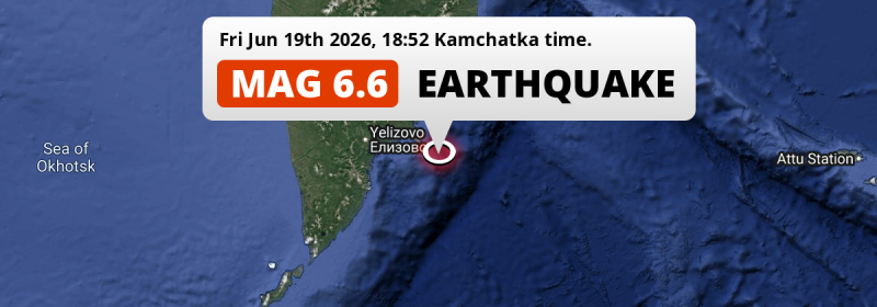
In the evening of Friday June 19th, 2026, a shallow and strong Magnitude 6.6 earthquake hit in the North Pacific Ocean 148 kilometer from Petropavlovsk-Kamchatsky, Russia. Mag 6.5+ earthquakes at shallow depth under sea have the potential to cause tsunami's.
Felt the earthquake? Share this article: 


Earthquake Summary
This earthquake hit under water in the North Pacific Ocean, 88 kilometers (55 mi) off the coast of Russia, 148 kilometer east of Petropavlovsk-Kamchatsky in Kamchatka. The center of this earthquake had a very shallow depth of 10 km. Shallow earthquakes usually have a larger impact than earthquakes deep in the earth.
| Date and Time: | Jun 19, 2026 18:52 (Kamchatka Time) - Jun 19, 2026 06:52 Universal Time. |
|---|---|
| Location: | 148 km east of Petropavlovsk-Kamchatsky, Kamchatka, Russia. Coordinates 52°47'28"N 160°46'57"E. |
| Map: | 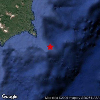 Map of area around epicenter. Click to open in Google Maps. |
| Magnitude: | MAG 6.6 Detected by 50 stations. Maximum Error Range ±0.044 . |
| Depth: | 10 km (6 mi) A very shallow depth. |
| Max. Intensity: | VI
Strong On the Modified Mercalli Scale. |
| Tsunami Risk: | Potential Tsunami Risk Mag 6.5+ earthquakes at shallow depth under sea have the potential to cause tsunami's. Always stay cautious - More info here. |
Potential Tsunami Risk
There is a potential tsunami risk in the aftermath of this earthquake, immediately evacuate to higher grounds away from coastal areas and monitor advice from local authorities. This earthquake checks all the likely tsunami risk factors: under sea, at a magnitude of MAG-6.5+ and at a shallow depth.
Tsunami Risk Factors
| Factor | Under Sea? | MAG-6.5 or stronger? | Shallow depth? |
|---|---|---|---|
| Explanation | Almost all tsunami's are caused by earthquakes with their epicenter under sea or very near the sea. However stay cautious in coastal areas as earthquakes on land may cause landslides into sea, potentially still causing a local tsunami. | Under MAG 6.5: Very unlikely to cause a tsunami. MAG 6.5 to 7.5: Destructive tsunami's do occur, but are uncommon. Likely to observe small sea level changes. MAG 7.6+: Earthquakes with these magnitudes might produce destructive tsunami's. |
Most destructive tsunami's are caused by shallow earthquakes with a depth between 0 and 100km under the surface of the earth. Deeper tsunami's are unlikely to displace to ocean floor. |
| This Earthquake | This earthquake appears to have struck under the sea. | This earthquake had a magnitude of 6.6. Earthquakes of this strength could trigger a tsunami. | This earthquake occurred at a depth of of 10 km (6 mi). Earthquakes this shallow could trigger a tsunami. |
Minimal impact predicted
Based on scientific estimates by the US Geographic Survey (USGS), the risk of high fatalities for this earthquake is classified at level GREEN (low). They expect an 90% likelyhood of between 0 and 1 fatalities.
The USGS classifies the economic impact of this earthquake at level GREEN (low). They expect an 90% likelyhood of between 0 and 1 million US Dollars in economic damage and impact.
Roughly 260 thousand people exposed to shaking
This earthquake may have been felt by around 260 thousand people. That is the expected population size of the area exposed to a level of shaking of II or higher on the Modified Mercalli scale according to the USGS.
An estimated 130 people were exposed to level V. At this level, moderate shaking and very light damage can be expected. The majority of people (roughly 260 thousand) live in an area exposed to level IV, where light shaking and likely no damage is expected. All exposure to shaking was within the borders of Russia .
| People | MMI Level | Shaking | Damage |
|---|---|---|---|
| 0 | I |
Not noticable | None |
| 0 | II |
Very weak | None |
| 730 | III |
Weak | Probably none |
| 255,600 | IV |
Light | Likely none |
| 130 | V |
Moderate | Very light |
| 0 | VI |
Strong | Light |
| 0 | VII |
Very Strong | Moderate |
| 0 | VIII |
Severe | Moderate to heavy |
| 0 | IX |
Violent | Heavy |
| 0 | X |
Extreme | Very heavy |
Nearby towns and cities
This earthquake may have been felt in Russia . The closest significant population center near the earthquake is Petropavlovsk-Kamchatsky in Kamchatka, Russia. Petropavlovsk-Kamchatsky is located 148 kilometer (92 mi) east of the epicenter. The intensity of shaking and damage in Petropavlovsk-Kamchatsky is estimated to be around level IV on the Modified Mercalli Intensity scale (light shaking, likely no damage).
Overview of nearby places
| Distance | Place | Intensity (MMI) |
|---|---|---|
| 148 km (92 mi) W from epicenter |
Petropavlovsk-Kamchatsky Kamchatka, Russia. |
IV
Light |
| 160 km (99 mi) W from epicenter |
Vilyuchinsk Kamchatka, Russia. |
IV
Light |
| 167 km (104 mi) W from epicenter |
Yelizovo Kamchatka, Russia. |
IV
Light |
Earthquake Intensity Map
The intensity in shaking and damage by this earthquake is illustrated through the map below. The highest intensity measured for this earthquake is V.

Shaking reported by 1 person
People that feel an earthquake may report their experience to the US Geographic Survey. Currently, 1 person has reported shaking in one place in Russia.We keep updating this article as more ground reports become available. You may report that you felt this earthquake here.
Places with most reports:
- Jelizovo, Kamčatka, Russia: 1 person.
24 Aftershocks detected
After this earthquake struck, 24 smaller aftershocks occurred. At a distance of 16 km (10 mi) south of this earthquake, an aftershock struck 21 hrs later. It measured a magnitude of 5.8
This main shock was prefaced by 2 smaller foreshocks. Roughly 1 min before this earthquake, a foreshock measuring MAG-6 was detected nearby this earthquake.
Overview of foreshocks and aftershocks
| Classification | Magnitude | When | Where |
|---|---|---|---|
| Foreshock | M 4.3 |
2 days earlier Jun 18, 2026 04:45 (Kamchatka Time) | 11 km (7 mi) S from Main Shock. |
| Foreshock | M 6.0 |
1 min earlier Jun 19, 2026 18:51 (Kamchatka Time) | 9 km (6 mi) SE from Main Shock. |
| Main Shock This Earthquake |
M 6.6 |
Jun 19, 2026 18:52 (Kamchatka Time) | - |
| Aftershock | M 5.0 |
4 mins later Jun 19, 2026 18:56 (Kamchatka Time) | 13 km (8 mi) SE from Main Shock. |
| Aftershock | M 4.9 |
13 mins later Jun 19, 2026 19:05 (Kamchatka Time) | 24 km (15 mi) E from Main Shock. |
| Aftershock | M 4.5 |
17 mins later Jun 19, 2026 19:09 (Kamchatka Time) | 10 km (6 mi) NE from Main Shock. |
| Aftershock | M 4.4 |
26 mins later Jun 19, 2026 19:18 (Kamchatka Time) | 10 km (6 mi) SE from Main Shock. |
| Aftershock | M 4.9 |
26 mins later Jun 19, 2026 19:18 (Kamchatka Time) | 34 km (21 mi) W from Main Shock. |
| Aftershock | M 4.3 |
30 mins later Jun 19, 2026 19:22 (Kamchatka Time) | 58 km (36 mi) S from Main Shock. |
| Aftershock | M 4.5 |
56 mins later Jun 19, 2026 19:48 (Kamchatka Time) | 20 km (12 mi) SE from Main Shock. |
| Aftershock | M 5.8 |
1 hr later Jun 19, 2026 19:52 (Kamchatka Time) | 17 km (11 mi) E from Main Shock. |
| Aftershock | M 5.2 |
1 hr later Jun 19, 2026 20:03 (Kamchatka Time) | 19 km (12 mi) SE from Main Shock. |
| Aftershock | M 4.1 |
1 hr later Jun 19, 2026 20:19 (Kamchatka Time) | 81 km (50 mi) S from Main Shock. |
| Aftershock | M 4.4 |
2 hrs later Jun 19, 2026 21:02 (Kamchatka Time) | 18 km (11 mi) SE from Main Shock. |
| Aftershock | M 4.4 |
4 hrs later Jun 19, 2026 22:40 (Kamchatka Time) | 6 km (4 mi) NE from Main Shock. |
| Aftershock | M 4.2 |
13 hrs later Jun 20, 2026 07:55 (Kamchatka Time) | 50 km (31 mi) NE from Main Shock. |
| Aftershock | M 4.3 |
20 hrs later Jun 20, 2026 14:46 (Kamchatka Time) | 55 km (34 mi) S from Main Shock. |
| Aftershock | M 4.3 |
20 hrs later Jun 20, 2026 14:46 (Kamchatka Time) | 8 km (5 mi) NW from Main Shock. |
| Aftershock | M 5.8 |
21 hrs later Jun 20, 2026 15:49 (Kamchatka Time) | 16 km (10 mi) S from Main Shock. |
| Aftershock | M 4.6 |
22 hrs later Jun 20, 2026 16:38 (Kamchatka Time) | 38 km (23 mi) NE from Main Shock. |
| Aftershock | M 4.1 |
22 hrs later Jun 20, 2026 16:41 (Kamchatka Time) | 39 km (24 mi) E from Main Shock. |
| Aftershock | M 4.1 |
23 hrs later Jun 20, 2026 17:32 (Kamchatka Time) | 25 km (15 mi) SE from Main Shock. |
| Aftershock | M 4.3 |
1 day later Jun 20, 2026 18:52 (Kamchatka Time) | 13 km (8 mi) NE from Main Shock. |
| Aftershock | M 4.2 |
2 days later Jun 21, 2026 11:43 (Kamchatka Time) | 12 km (7 mi) NE from Main Shock. |
| Aftershock | M 4.2 |
2 days later Jun 21, 2026 22:54 (Kamchatka Time) | 33 km (20 mi) E from Main Shock. |
| Aftershock | M 4.5 |
2 days later Jun 22, 2026 00:12 (Kamchatka Time) | 14 km (9 mi) SE from Main Shock. |
| Aftershock | M 4.3 |
3 days later Jun 22, 2026 18:24 (Kamchatka Time) | 73 km (45 mi) SW from Main Shock. |
More earthquakes coming?
Earthquakes can create aftershocks. These are generally at least 1 magnitude lower than any main shock, and as time passes the chance and strength of aftershocks decreases.
It's always adviced to be cautious of the risk of a larger shock following any significant earthquake, however this risk is fairly small. There is a roughly 94 percent change that no larger main shock will follow in the days following this earthquake.
Read: How to Stay Safe during an Earthquake (cdc.gov).Earthquakes like this are common in the region
Earthquakes of this strength occur quite regularly in the region. This is the strongest earthquake to hit since September 18th, 2025, when a 7.8 magnitude earthquake hit 39 km (24 mi) further north. An even stronger magnitude 8.8 earthquake struck on July 29th, 2025.
In total, 6 earthquakes with a magnitude of 6.6 or higher have been registered within 300km (186 mi) of this epicenter in the past 10 years. This comes down to an average of once every 2 years.
Sources
Last updated 30/07/26 12:28 (). This article contains currently available information about the earthquake and is automatically composed. We continue to update this article up to a few days after the earthquake occurred.
- US Geographic Society (USGS): Earthquake us7000sui3
- European-Mediterranean Seismological Centre (EMSC): Earthquake 20260619_0000087
- Geonames.org: World Cities Database
- Google Maps: Static API
- Earthquakelist.org: Historic Earthquakes Database
Share this article:
