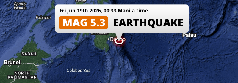
In the night of Friday June 19th, 2026, a shallow and significant MAG-5.2 earthquake hit in the Philippine Sea 84 kilometer from Mati, The Philippines.
Felt the earthquake? Share this article: 


Earthquake Summary
This earthquake hit under water in the Philippine Sea, 62 kilometers (39 mi) off the coast of The Philippines, 84 kilometer south-east of Mati in Davao. The center of this earthquake had a very shallow depth of 10 km. Shallow earthquakes usually have a larger impact than earthquakes deep in the earth.
| Date and Time: | Jun 19, 2026 12:33AM (Manila Time) - Jun 18, 2026 16:33 Universal Time. |
|---|---|
| Location: | 84 km SE of Mati, Davao, The Philippines. Coordinates 6°29'3"N 126°48'26"E. |
| Map: | 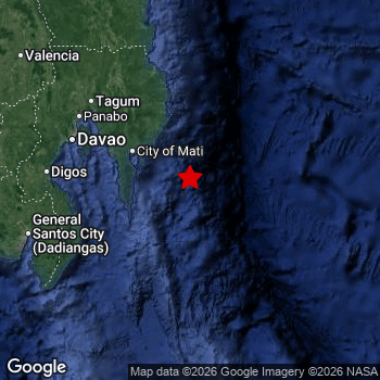 Map of area around epicenter. Click to open in Google Maps. |
| Magnitude: | MAG 5.2 Detected by 126 stations. Maximum Error Range ±0.054 . |
| Depth: | 10 km (6 mi) A very shallow depth. |
| Tsunami Risk: | Low tsunami risk Earthquakes under MAG-6.5 do not usually cause tsunami's. Always stay cautious - More info here. |
Nearby towns and cities
This earthquake may have been felt in The Philippines . The closest significant population center near the earthquake is Mati in Davao, The Philippines. Mati is located 84 kilometer (52 mi) south-east of the epicenter.
Major cities near this earthquake: Davao is located 147 km to the northwest. Budta is located 273 km to the west. Malingao is located 268 km to the west.
The table below provides an overview of all places in proximity of today's earthquake.
Overview of nearby places
| Distance | Place |
|---|---|
| 84 km (52 mi) NW from epicenter |
Mati Davao, The Philippines. |
| 86 km (53 mi) N from epicenter |
Manay Davao, The Philippines. |
| 99 km (62 mi) NW from epicenter |
Lupon Davao, The Philippines. |
| 132 km (82 mi) W from epicenter |
Malita Davao, The Philippines. |
| 138 km (86 mi) NW from epicenter |
Samal Davao, The Philippines. |
| 144 km (89 mi) NW from epicenter |
San Mariano Davao, The Philippines. |
| 147 km (91 mi) NW from epicenter |
Davao Davao, The Philippines. |
| 148 km (92 mi) W from epicenter |
Santa Maria Davao, The Philippines. |
| 154 km (96 mi) NW from epicenter |
Compostela Davao, The Philippines. |
| 154 km (96 mi) NW from epicenter |
Magugpo Poblacion Davao, The Philippines. |
| 154 km (96 mi) NW from epicenter |
Panabo Davao, The Philippines. |
| 156 km (97 mi) NW from epicenter |
Nabunturan Davao, The Philippines. |
| 157 km (98 mi) NW from epicenter |
Cabayangan Davao, The Philippines. |
| 163 km (101 mi) W from epicenter |
Digos Davao, The Philippines. |
| 164 km (102 mi) NW from epicenter |
New Corella Davao, The Philippines. |
| 170 km (106 mi) W from epicenter |
Maluñgun Soccsksargen, The Philippines. |
| 170 km (106 mi) NW from epicenter |
Monkayo Davao, The Philippines. |
| 173 km (107 mi) W from epicenter |
Alabel Soccsksargen, The Philippines. |
| 177 km (110 mi) W from epicenter |
Malapatan Soccsksargen, The Philippines. |
| 179 km (111 mi) W from epicenter |
Bansalan Davao, The Philippines. |
| 182 km (113 mi) W from epicenter |
Magsaysay Davao, The Philippines. |
| 185 km (115 mi) W from epicenter |
General Santos Soccsksargen, The Philippines. |
| 192 km (119 mi) NW from epicenter |
Trento Caraga, The Philippines. |
| 192 km (119 mi) SW from epicenter |
Glan Soccsksargen, The Philippines. |
| 195 km (121 mi) W from epicenter |
Polomolok Soccsksargen, The Philippines. |
| 198 km (123 mi) W from epicenter |
Kidapawan Soccsksargen, The Philippines. |
| 200 km (124 mi) NW from epicenter |
Veruela Caraga, The Philippines. |
| 200 km (124 mi) N from epicenter |
Bislig Caraga, The Philippines. |
| 206 km (128 mi) W from epicenter |
Tupi Soccsksargen, The Philippines. |
| 208 km (129 mi) NW from epicenter |
Bunawan Caraga, The Philippines. |
| 217 km (135 mi) W from epicenter |
Koronadal Soccsksargen, The Philippines. |
| 223 km (139 mi) W from epicenter |
Buluan Rehiyong Autonomo sa Muslim na Mindanao, The Philippines. |
| 224 km (139 mi) W from epicenter |
Bañga Soccsksargen, The Philippines. |
| 228 km (142 mi) W from epicenter |
Surallah Soccsksargen, The Philippines. |
| 229 km (142 mi) W from epicenter |
Kabacan Soccsksargen, The Philippines. |
| 234 km (145 mi) NW from epicenter |
Quezon Northern Mindanao, The Philippines. |
| 234 km (145 mi) W from epicenter |
Lake Sebu Soccsksargen, The Philippines. |
| 237 km (147 mi) W from epicenter |
Tacurong Soccsksargen, The Philippines. |
| 239 km (149 mi) NW from epicenter |
Don Carlos Northern Mindanao, The Philippines. |
| 244 km (152 mi) W from epicenter |
Isulan Soccsksargen, The Philippines. |
| 244 km (152 mi) NW from epicenter |
Maramag Northern Mindanao, The Philippines. |
| 246 km (153 mi) NW from epicenter |
NIA Valencia Northern Mindanao, The Philippines. |
| 256 km (159 mi) NW from epicenter |
Bah-Bah Caraga, The Philippines. |
| 263 km (163 mi) W from epicenter |
Midsayap Soccsksargen, The Philippines. |
| 263 km (163 mi) NW from epicenter |
Malaybalay Northern Mindanao, The Philippines. |
| 268 km (167 mi) W from epicenter |
Malingao Soccsksargen, The Philippines. |
| 273 km (170 mi) W from epicenter |
Budta Rehiyong Autonomo sa Muslim na Mindanao, The Philippines. |
| 277 km (172 mi) NW from epicenter |
Bayugan Caraga, The Philippines. |
| 278 km (173 mi) W from epicenter |
Pagaluñgan Rehiyong Autonomo sa Muslim na Mindanao, The Philippines. |
| 294 km (183 mi) W from epicenter |
Cotabato Rehiyong Autonomo sa Muslim na Mindanao, The Philippines. |
| 297 km (185 mi) W from epicenter |
Parang Rehiyong Autonomo sa Muslim na Mindanao, The Philippines. |
Shaking reported by 1 person
People that feel an earthquake may report their experience to the US Geographic Survey. Currently, 1 person has reported shaking in one place in Philippines.We keep updating this article as more ground reports become available. You may report that you felt this earthquake here.
Places with most reports:
- Canocotan, Southern Mindanao, Philippines: 1 person.
5 Aftershocks detected
Since this main shock, 5 smaller aftershocks were detected. Just 2 days after this main shock, an earthquake measuring MAG-3.9 was detected 30 km (18 mi) north of this earthquake.
In the days before this main shock, 5 smaller foreshocks were detected. Roughly 19 hrs before this earthquake, a foreshock measuring MAG-4.7 was detected nearby this earthquake.
Overview of foreshocks and aftershocks
| Classification | Magnitude | When | Where |
|---|---|---|---|
| Foreshock | M 3.1 |
1 day earlier Jun 17, 2026 01:25PM (Manila Time) | 42 km (26 mi) W from Main Shock. |
| Foreshock | M 3.1 |
1 day earlier Jun 17, 2026 10:21PM (Manila Time) | 6 km (4 mi) S from Main Shock. |
| Foreshock | M 4.7 |
19 hrs earlier Jun 18, 2026 05:49AM (Manila Time) | 14 km (9 mi) N from Main Shock. |
| Foreshock | M 3.1 |
18 hrs earlier Jun 18, 2026 06:31AM (Manila Time) | 65 km (41 mi) N from Main Shock. |
| Foreshock | M 3.2 |
17 hrs earlier Jun 18, 2026 07:05AM (Manila Time) | 28 km (18 mi) NW from Main Shock. |
| Main Shock This Earthquake |
M 5.2 |
Jun 19, 2026 12:33AM (Manila Time) | - |
| Aftershock | M 3.0 |
8 hrs later Jun 19, 2026 08:15AM (Manila Time) | 22 km (14 mi) W from Main Shock. |
| Aftershock | M 3.4 |
23 hrs later Jun 19, 2026 11:53PM (Manila Time) | 92 km (57 mi) SW from Main Shock. |
| Aftershock | M 3.1 |
1 day later Jun 20, 2026 01:58AM (Manila Time) | 64 km (40 mi) SW from Main Shock. |
| Aftershock | M 3.9 |
2 days later Jun 20, 2026 12:35PM (Manila Time) | 30 km (18 mi) N from Main Shock. |
| Aftershock | M 3.1 |
2 days later Jun 20, 2026 05:23PM (Manila Time) | 69 km (43 mi) W from Main Shock. |
More earthquakes coming?
Earthquakes can create aftershocks. These are generally at least 1 magnitude lower than any main shock, and as time passes the chance and strength of aftershocks decreases.
It's always adviced to be cautious of the risk of a larger shock following any significant earthquake, however this risk is fairly small. There is a roughly 94 percent change that no larger main shock will follow in the days following this earthquake.
Read: How to Stay Safe during an Earthquake (cdc.gov).Earthquakes like this happen often in the region
Earthquakes of this strength are very common in the region. This is the strongest earthquake to hit since June 15th, 2026, when a 5.5 magnitude earthquake hit 196 km (122 mi) further southwest. An even stronger magnitude 7.8 earthquake struck on June 7th, 2026.
In total, 222 earthquakes with a magnitude of 5.2 or higher have been registered within 300km (186 mi) of this epicenter in the past 10 years. This comes down to an average of once every 16 days.
Low tsunami risk
Based on early data it appears this earthquake was not strong enough (lower than MAG-6.5) to be likely to cause destructive tsunami's. However this earthquake appeared to have hit at a shallow depth under sea, so stay cautious and monitor advice from local authorities.
Tsunami Risk Factors
| Factor | Under Sea? | MAG-6.5 or stronger? | Shallow depth? |
|---|---|---|---|
| Explanation | Almost all tsunami's are caused by earthquakes with their epicenter under sea or very near the sea. However stay cautious in coastal areas as earthquakes on land may cause landslides into sea, potentially still causing a local tsunami. | Under MAG 6.5: Very unlikely to cause a tsunami. MAG 6.5 to 7.5: Destructive tsunami's do occur, but are uncommon. Likely to observe small sea level changes. MAG 7.6+: Earthquakes with these magnitudes might produce destructive tsunami's. |
Most destructive tsunami's are caused by shallow earthquakes with a depth between 0 and 100km under the surface of the earth. Deeper tsunami's are unlikely to displace to ocean floor. |
| This Earthquake | This earthquake appears to have struck under the sea. | Not this earthquake. This earthquake had a magnitude of 5.2. Earthquakes of this strength are unlikely to trigger a tsunami. |
This earthquake occurred at a depth of of 10 km (6 mi). Earthquakes this shallow could trigger a tsunami. |
Sources
Last updated 08/07/26 01:28 (). As more information on this earthquake becomes available this article will be updated. This article is automatically composed based on data originating from multiple sources.
- US Geographic Society (USGS): Earthquake us7000sucj
- European-Mediterranean Seismological Centre (EMSC): Earthquake 20260618_0000248
- Geonames.org: World Cities Database
- Google Maps: Static API
- Earthquakelist.org: Historic Earthquakes Database
Share this article:
